* A Distributed Proofreaders Canada eBook *
This ebook is made available at no cost and with very few restrictions. These restrictions apply only if (1) you make a change in the ebook (other than alteration for different display devices), or (2) you are making commercial use of the ebook. If either of these conditions applies, please contact a FP administrator before proceeding.
This work is in the Canadian public domain, but may be under copyright in some countries. If you live outside Canada, check your country's copyright laws. IF THE BOOK IS UNDER COPYRIGHT IN YOUR COUNTRY, DO NOT DOWNLOAD OR REDISTRIBUTE THIS FILE.
Title: Canada and its Provinces Vol 1 of 23
Date of first publication: 1914
Author: Adam Shortt (1859-1931) and Arthur G. Doughty (1860-1936)
Date first posted: July 19, 2016
Date last updated: July 19, 2016
Faded Page eBook #20160715
This ebook was produced by: Marcia Brooks, Alex White & the online Distributed Proofreaders Canada team at http://www.pgdpcanada.net
Archives Edition
CANADA AND ITS PROVINCES
IN TWENTY-TWO VOLUMES AND INDEX
| (Vols. 1 and 2) | (Vols. 13 and 14) |
| SECTION I | SECTION VII |
| NEW FRANCE, 1534-1760 | THE ATLANTIC PROVINCES |
| (Vols. 3 and 4) | (Vols. 15 and 16) |
| SECTION II | SECTION VIII |
| BRITISH DOMINION, 1760-1840 | THE PROVINCE OF QUEBEC |
| (Vol. 5) | (Vols. 17 and 18) |
| SECTION III | SECTION IX |
| UNITED CANADA, 1840-1867 | THE PROVINCE OF ONTARIO |
| (Vols. 6, 7, and 8) | (Vols. 19 and 20) |
| SECTION IV | SECTION X |
| THE DOMINION: POLITICAL EVOLUTION | THE PRAIRIE PROVINCES |
| (Vols. 9 and 10) | (Vols. 21 and 22) |
| SECTION V | SECTION XI |
| THE DOMINION: INDUSTRIAL EXPANSION | THE PACIFIC PROVINCE |
| (Vols. 11 and 12) | (Vol. 23) |
| SECTION VI | SECTION XII |
| THE DOMINION: MISSIONS; ARTS AND LETTERS | DOCUMENTARY NOTES GENERAL INDEX |
GENERAL EDITORS
ADAM SHORTT
ARTHUR G. DOUGHTY
ASSOCIATE EDITORS
Thomas Chapais
F. P. Walton
William L. Grant
James Bonar
D. M. Duncan
Alfred D. DeCelles
George M. Wrong
Andrew Macphail
A. H. U. Colquhoun
Robert Kilpatrick
Thomas Guthrie Marquis
VOL. 1
SECTION I
NEW FRANCE
PART I
Photogravure. Annan. Glasgow.
JACQUES CARTIER
From the painting at St Malo
Copyright in all countries subscribing to
the Berne Convention
Seldom in the history of a nation has there been such rapid economic development as Canada has enjoyed during the last two decades. Within that time the Dominion has felt the throb of a new industrial life from ocean to ocean. Railroads have opened up to the settler vast stretches of fertile soil. Immigration has proceeded vigorously, and the country has received a large influx of population from both Europe and the United States. Wide tracts of prairie land, which twenty years ago were uninhabited and which appalled the traveller by their unbroken solitude, are now dotted with the buildings of the settler. Cities and towns have sprung up, as in a night, equipped with the conveniences of modern civilization. The increase in the production of gold and silver has been no less phenomenal—the fame of the Yukon and of the Cobalt region has gone all over the world. From Sydney on the Atlantic to Prince Rupert on the Pacific the signs of rapid advancement are everywhere visible. Vacant lands are being settled, mineral resources exploited, great rivers bridged and mountains scaled or tunnelled. The shifting of population from the older and historic settlements to the new sections and from rural districts to urban centres is also a feature of the present situation. While European nations have been devoting much of their energy to navies and armies, Canada has been concentrating all her forces on the conquest of nature for the use of man.
But, in the enthusiasm of commercial and industrial activity, of increasing wealth and population, it is not to be forgotten that the national character is not moulded exclusively by economic causes. Flung over an enormous geographic range, the Canadian communities are not yet bound together by continuity of settlement. There remain differences of environment, of local interest, of language and race. Under such conditions the danger of sectionalism, in spite of material success, is greatly to be feared, unless this destructive tendency is met by the positive and constructive idea of the Nation.
To the end that a broad national spirit should prevail in all parts of the Dominion, it is desirable that a sound knowledge of Canada as a whole, of its history, traditions and standards of life, should be diffused among its citizens, and especially among the immigrants who are peopling the new lands. Commercial and industrial ambition, so strong a motive in every new country, will naturally lead men to inform themselves concerning its business advantages, but mere wealth-making is not the chief essential of citizenship. Good citizenship grows out of a patriotic interest in the institutions of one’s country and a sympathy with the people who dwell there. Such interest and sympathy are possible in large measure only to those who are familiar with their country’s past. Now, Canada’s past, though brief compared with that of the Motherland or other European countries, is full of interest, instruction, and even romance. The story of the early centuries is fascinating and dramatic. It has its conspicuous examples of high endeavour and brave accomplishment—such as the heart of youth always delights in—in defence, in business enterprise, in education, in religion and in statecraft. Without exaggerating its favourable features or minimizing or ignoring those that are less attractive, the record of the stages through which Canada’s various provinces have passed, from the state of nature in which they were found by the first European explorers and settlers to their present condition of civilization, may be so presented as to awaken not only the interest but the patriotic pride of every intelligent citizen. With this story every Canadian should be acquainted, both for his own enlightenment and for the good of the state.
The work which is here presented to the public has been planned and undertaken on a comprehensive scale, both in the sense that it covers the entire history of Canada and its provinces, and in the sense that those who write represent all parts of the Dominion and their more or less diverse points of view. The range of facts is so wide and the topics so various and complex that no one author could possibly compass them. The work, therefore, has been apportioned among many writers, each of whom has some special sympathy and aptitude for the topic with which he deals. In adopting this co-operative plan the Editors have followed not merely the logic of their theme, but the practice of modern historians in other and older countries.
The co-operative method, while involving the Editors in some difficulties, has obvious advantages to the reader. Although two or more writers may deal with the same event or personality, they do so from different angles, and what sometimes appears to be duplication serves to clarify a complex situation by presenting it from more than one point of view. A financial measure, for instance, having as a direct object the raising of revenue, is dealt with in that aspect by the writer on public finance. But the same measure in its course through parliament may have proved the occasion of a political crisis; in that phase it is treated by one of the writers dealing with political history. The measure may also have affected domestic trade or foreign trade relations, raising questions for the consideration of a third writer whose subject is economic history. From each of the three standpoints new light is given, and a comprehensive view of the whole matter is thus afforded.
The plan of the work embraces twelve main divisions or sections as follows:
| I. | New France, 1534-1760. |
| II. | British Dominion, 1760-1840. |
| III. | United Canada, 1840-1867. |
| IV. | The Dominion: Political Evolution. |
| V. | The Dominion: Industrial Expansion. |
| VI. | The Dominion: Missions, Arts and Letters. |
| VII. | The Atlantic Provinces. |
| VIII. | The Province of Quebec. |
| IX. | The Province of Ontario. |
| X. | The Prairie Provinces. |
| XI. | The Pacific Province. |
| XII. | Documentary Notes. |
| General Index. |
It will be observed that these titles indicate two distinct classes of history—one general or national, and the other local or provincial. A recital here of all the considerations which led the Editors to adopt this system would be of little service to the reader. It is enough to say that the Editors arrived at this method after much study and experiment, and that in their judgment it appears to be the only way in which a complete historical survey can be made of the Canadian people and their institutions. Broadly, the first six sections cover New France, the two Canadas, United Canada, and the Dominion. The topics treated in the five provincial sections may be generalized as (1) Pioneer Settlement, (2) Provincial Political History since Confederation, (3) Provincial and Municipal Government, (4) Education, and (5) Resources. In general it may be said that all matters of Canadian history not covered by one of these heads are to be looked for in the first six sections, although there are necessarily deviations from this rule. The pre-Confederation history of the Atlantic Provinces, for instance, has little connection with that of the Canadas, and it is therefore given in the provincial section. The same is true of British Columbia.
Although the normal historical order is followed as closely as possible, the work is arranged on topical rather than on chronological lines. This makes it possible and convenient to institute comparisons, if desired, between one province and another in the same matter. Thus it will be seen that the work may serve the reader in a variety of ways: (1) as a general history of Canada, (2) as a special history of any one of the provinces, (3) as a comparative history of similar institutions in the different provinces, or (4) as an independent study of any leading historical topic relating to Canada. For specific events or facts the General Index will supply a full and ready guide. The Documentary Notes in the final volume will traverse the text of the narratives and cite authorities.
The average citizen cannot be expected to know the story of his country in every detail, but he should know its outstanding events, personalities and tendencies, while those who are creating and guiding public opinion should have at their command at all times the fullest possible information for use as each new occasion may demand. With knowledge, the prejudice and narrowness of sectionalism give way to an enlightened patriotism which vibrates to the sentiment of nationality and holds high above all else the welfare of the whole commonwealth. For these and other reasons the preparation of a comprehensive history of Canada at the present time may be regarded as a contribution to the development of the Dominion.
Ottawa, December 1, 1912.
| PAGE | |||
| NEW FRANCE: A GENERAL SURVEY. By Thomas Chapais | 3 | ||
| THE BEGINNINGS OF CANADA. By Arthur G. Doughty | |||
| I. | THE FORERUNNERS OF JACQUES CARTIER | 17 | |
| Introduction—The Voyages of John Cabot—Other Early Voyages | |||
| II. | THE VOYAGES OF JACQUES CARTIER | 27 | |
| Cartier’s First Voyage—Cartier’s Second Voyage—Cartier and Roberval | |||
| THE PATHFINDERS OF THE GREAT LAKES. By James H. Coyne | |||
| I. | FIRST VOYAGES WESTWARD | 45 | |
| II. | CHAMPLAIN ON THE OTTAWA, 1613 | 48 | |
| III. | CHAMPLAIN IN THE LAKE REGION, 1615 | 52 | |
| IV. | BRÛLÉ AND THE RÉCOLLETS | 56 | |
| V. | NICOLET AT GREEN BAY | 60 | |
| VI. | LA ROCHE D’AILLON AMONG THE NEUTRALS, 1626-27 | 62 | |
| VII. | A DISHEARTENING MISSION | 64 | |
| VIII. | THE NORTH-WEST TRADE ROUTE | 68 | |
| IX. | RADISSON AND GROSEILLIERS | 71 | |
| X. | NORTH OF LAKE SUPERIOR | 77 | |
| XI. | THE JESUITS ON THE UPPER LAKES | 80 | |
| XII. | TALON AND THE LAKE REGION | 81 | |
| XIII. | THE SULPICIANS ON LAKE ONTARIO | 85 | |
| XIV. | DOLLIER DE CASSON, GALINÉE AND LA SALLE | 87 | |
| XV. | LA SALLE AND THE SENECAS | 89 | |
| XVI. | LA SALLE AND JOLLIET | 92 | |
| XVII. | A WINTER ON THE SHORES OF LAKE ERIE | 95 | |
| XVIII. | THE SULPICIANS AT SAULT STE MARIE | 96 | |
| XIX. | THE RETURN TO MONTREAL | 99 | |
| XX. | THE MISSISSIPPI | 101 | |
| XXI. | THE GREYSOLONS | 104 | |
| XXII. | THE MAP OF THE LAKES | 106 | |
| THE PATHFINDERS OF THE GREAT WEST. By Lawrence J. Burpee | |||
| I. | THE ROUTE TO THE WESTERN SEA | 111 | |
| Early Glimpses of the West—The Gateway to the North-West—Exploration North of Lake Superior | |||
| II. | LA VÉRENDRYE AND HIS SONS | 117 | |
| Pierre Gaultier de la Vérendrye—Winnipeg River and Lake—The Assiniboine Indians—In the Mandan Country—In Sight of the Rocky Mountains—Route of La Vérendrye Brothers—Discovery of the Saskatchewan—Last Years of La Vérendrye | |||
| III. | SAINT-PIERRE AND DE NIVERVILLE | 137 | |
| La Vérendrye’s Successor—Ascent of the Saskatchewan—Saint-Pierre’s Defects as an Explorer | |||
| IV. | LAST GLIMPSES OF THE FRENCH POSTS | 144 | |
| THE ‘ADVENTURERS’ OF HUDSON’S BAY. By T. G. Marquis | |||
| I. | PIONEER VOYAGES TO HUDSON BAY | 149 | |
| II. | THE COMING OF THE FUR LORDS | 159 | |
| III. | FOUNDING OF THE HUDSON’S BAY COMPANY | 165 | |
| IV. | NEW FRANCE AROUSED | 170 | |
| V. | ARMED CONFLICT ON HUDSON BAY | 176 | |
| VI. | DARK DAYS FOR THE HUDSON’S BAY COMPANY | 188 | |
| VII. | AN ERA OF EXPLORATION | 193 | |
| LOUISBOURG: AN OUTPOST OF EMPIRE. By J. S. McLennan | |||
| I. | THE FOUNDING OF LOUISBOURG | 201 | |
| Motives for the Establishment—Fortification, Garrison and Administration—Growth of the Settlement | |||
| II. | THE FIRST SIEGE | 210 | |
| The War of the Austrian Succession—Plans of New England against Louisbourg—The New England Forces—Unparalleled Features of the Siege | |||
| III. | THE SIEGE OF 1758 | 219 | |
| Louisbourg’s Increased Importance—Amherst’s Attack—The Capture of the Fortress | |||
| THE FIGHT FOR OVERSEA EMPIRE. By William Wood | |||
| I. | THE SEVEN YEARS’ WAR | 231 | |
| A Great Imperial War—The French in America—Indians and Rival Whites—British and French in the Ohio Valley | |||
| II. | HOSTILITIES BEFORE THE WAR | 238 | |
| Braddock’s Plans and Difficulties—British Defeat at Fort Duquesne—Johnson’s Success at Lake George—Deportation of the Acadians | |||
| III. | DECLARATION OF WAR, 1756 | 246 | |
| The Combatants—The French Position—Montcalm and Vaudreuil—British Preparations—The Capture of Oswego—A Year of British Disaster | |||
| IV. | FORT WILLIAM HENRY | 254 | |
| The Campaign in Europe—Loudoun’s Tactics—Montcalm and the Indians—Surrender of the Fort—Massacre by the Indians | |||
| V. | PITT’S GREAT ADMINISTRATION | 260 | |
| A New Imperial Force—Corruption in Official Life—British Disaster at Ticonderoga—The Turning Point of the War | |||
| VI. | THE DECISIVE YEAR | 269 | |
| French Designs on England—Pitt as a World-Strategist—British and French Plans—The War in the West | |||
| VII. | THE SIEGE OF QUEBEC | 275 | |
| Desperate State of the Colony—Wolfe and his Forces—The Fortress and its Defenders—Incidents of the Siege—The Crisis at Hand | |||
| VIII. | THE BATTLE OF THE PLAINS | 288 | |
| Preliminary Plans and Manœuvres—Ascent of the Heights—Awaiting the French Attack—Rout of the French—Death of Wolfe and Montcalm | |||
| IX. | THE FALL OF NEW FRANCE | 308 | |
| The Battle of Ste Foy—Vaudreuil’s Surrender of Canada | |||
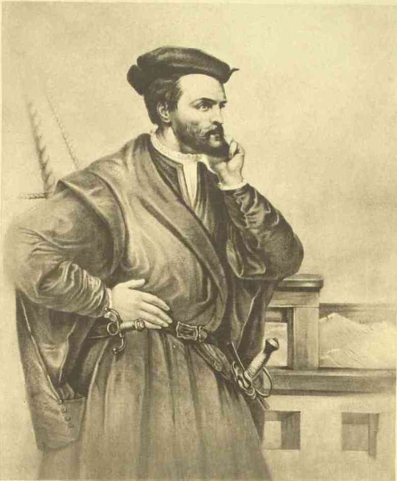
| JACQUES CARTIER | Frontispiece | ||
| From the painting at St Malo | |||
| JOHN CABOT AND HIS SON SEBASTIAN | Facing page | 18 | |
| From the model by John Cassidy | |||
| ROUTES OF EXPLORERS | ″ | 46 | |
| Map by Bartholomew | |||
| PRINCE RUPERT | ″ | 166 | |
| From the painting by Sir Peter Lely in the National Portrait Gallery | |||
| EDWARD BOSCAWEN | ″ | 222 | |
| From the painting by Sir Joshua Reynolds in the National Portrait Gallery | |||
| MARQUIS DE MONTCALM | ″ | 256 | |
| After the original painting owned by the Marquis de Montcalm | |||
| FACSIMILE OF A LETTER CONCERNING A PLAN OF QUEBEC BY PAT. MACKELLAR, ENGINEER-IN-CHIEF AT THE SIEGE OF QUEBEC | ″ | 260 | |
| WILLIAM PITT, EARL OF CHATHAM | ″ | 262 | |
| From a painting in the National Portrait Gallery | |||
| JAMES WOLFE | ″ | 278 | |
| From a painting in the National Portrait Gallery | |||
| FACSIMILE OF WOLFE’S WILL | ″ | 280 | |
| GEORGE, MARQUIS TOWNSHEND | ″ | 290 | |
| From the painting by Sir Joshua Reynolds | |||
| THE DEATH OF WOLFE | ″ | 304 | |
| After the painting by Benjamin West | |||
| FACSIMILE OF MONTCALM’S LETTER TO THE BRITISH COMMANDER AFTER THE BATTLE OF THE PLAINS | ″ | 306 | |
New France! We never write these words without being vividly impressed with their deep meaning. That name, so sweet and so dear to thousands of good and loyal Canadians, is the adequate expression of a social and ethnical reality.
It was truly another France that the old France set herself to establish on the Laurentian shores at the beginning of the seventeenth century. Giovanni da Verrazano, a Florentine navigator in her service, was the first, it is thought, to give that name to some parts of the American coast, including Nova Scotia and Cape Breton, in 1524. Later on, Jacques Cartier, in the relation of his second journey to America, speaks of ‘the countries and kingdoms of Hochelaga and Canada, named by us New France.’ After a lapse of over half a century the Sieur de Monts, Poutrincourt and Champlain attempted to make an establishment in Acadia, and their companion, Marc Lescarbot, wrote the narrative of this ill-fated enterprise in his interesting book, the History of New France. But to the lot of Samuel Champlain fell the glory of being the father of a new French nation in America. The founding of Quebec, on July 3, 1608, is really the first chapter of the history of New France.
The beginnings of this colony were hard and humble. For years Quebec was the only post occupied by the French, and its population was at most about sixty persons. The companies which were granted the monopoly of the fur trade did not trouble themselves with the cares of colonization, but were mainly anxious to secure good returns for their outlay. Their aim was trade, while Champlain’s was colonization. He struggled during his whole life with his principals in France, in order to make them acquiesce in his broad and far-reaching views. The taking of Quebec by the Kirkes in 1629 interrupted his efforts for a few years. When the English resigned Canada to France in 1632, he came back to this land of his adoption, and in 1635 he saw the end of his arduous, noble and worthy career.
Under his successors, Montmagny (1636-48), d’Ailleboust (1648-51), de Lauzon (1651-57), d’Argenson (1658-61), d’Avaugour (1661-63), the poor and weak colony had to undergo all sorts of difficulties, hardships and disasters. The Company of One Hundred Associates, to which Louis XIII and Richelieu had granted the landlordship of New France in 1627, never fulfilled the conditions of that grant. Only a few hundred settlers came to the colony from 1632 to 1660. The agricultural establishments were few. The fur trade was hampered by the war waged against the French by the fierce Iroquois. The governors were almost powerless to check the bloody incursions of these daring foes. Missionaries and preachers of the Gospel paid the penalty of torture and death as a reward for their heroic zeal and Christian devotion.
During this whole period the mother country was involved in internal troubles and European conflicts that diverted the attention of her government from the wretched colony which seemed doomed to destruction. The strong mind and arm of Cardinal de Richelieu had to grapple with so many problems at home and abroad that the great minister could not follow the plans of colonial policy he had outlined at an earlier date. After his death, and during the minority of Louis XIV, the situation did not improve. The queen-mother, Anne of Austria, and the prime minister, Cardinal Mazarin, had to face the aristocratic and parliamentary movement known in history under the name of the Fronde, which ended in a civil war. So deeply entangled were they that they could not come to the rescue of New France’s dying establishments.
At last the great reign of Louis XIV began to make its beneficent influence felt even on our shores. The young king and his sagacious minister, Colbert, listened to the entreaties of our governors, of Monseigneur de Laval, Bishop of Quebec, and of the delegates sent from Canada to the court. It was decided to cancel the charter of the Hundred Associates, and to establish in the colony a new form of government. With some alterations this constitution remained in existence during the whole French régime. In the month of April 1663 a royal edict created the Sovereign or Supreme Council of Quebec, composed of the governor, the bishop, the intendant, an attorney-general, and five councillors. Later on the name of the council was changed to that of Superior Council, and the number of councillors was raised to seven and ultimately to twelve. This body was invested with a general jurisdiction for the administration of justice in civil and criminal matters. It had also to deal with questions of police, roads, finance and trade.
At the head of the colony were three high officials, the governor, the bishop, the intendant. The governor was the direct representative of the king’s authority. He was commander of the troops, and possessed great power in the general management of the colony’s affairs. The relations with the foreign colonies and the Indians were in his exclusive province. The bishop, as head of the church and second member of the council, exercised an important influence. In the time of Monseigneur de Laval that influence was felt in political matters, and, we may add, for the good of the colony. But in later years it was rather of a moral and social character. The intendant had the control of all the administrative business. His jurisdiction was wide, and extended over judicatory, financial, police, seigneurial and trade matters.
Parkman has reminded us in The Old Régime in Canada that the government of the colony was formed in its chief features after the government of a French province. And that remark is true. Take, for instance, Brittany under Louis XIV. There we find the governor, a noble of high rank; we find, of course, a bishop, or rather an archbishop, wielding great social influence; an intendant selected from the legal clan and trained to administration; and a local parliament, to which corresponded in many respects our Superior Council of Quebec.
Not satisfied to find here, as far as local government was concerned, the mere reproduction of a French province, one of the governors of New France displayed a higher ambition, and attempted an imitation of those great assemblies of the three orders of the nation, the clergy, the nobility and the ‘third estate,’ called the States-General of the kingdom. Count Frontenac, at the opening of his administration, summoned a number of ecclesiastics, of officers and seigneurs, and of tradesmen, to meet on an appointed day. On that occasion he delivered a speech in which he extolled the power and glory of Louis XIV, and exhorted his hearers to be always loyal and devoted to that great and mighty sovereign. The speech was followed by the ceremony of the oath taken by the three orders of the Canadian community. This new departure does not seem to have been appreciated by the court in France. Commenting on the incident, Colbert wrote to Frontenac:
The assembling of the inhabitants for their swearing in and your division of them into three orders may have been productive of some good for the moment, but you should bear in mind that you are always to follow, in the government of Canada, the forms that obtain here; and, since our kings for a long time have thought it advisable not to summon the States-General of the kingdom, you should seldom, or to be more precise, never, give that form to the population of Canada. It would even be well, after some time, when the colony shall be stronger, if you could suppress the syndic who presents petitions in the name of the inhabitants, as it is well that each one should speak for himself and no one in the name of others.
In studying the constitution of New France we can see at once that one of its weak points was the dualism of powers. By the scope of their respective jurisdictions the governor and the intendant were likely to trespass on each other’s authority and to cross swords on many occasions. Friction was bound to occur, and it did. The celebrated governor-general, Count Frontenac, and the intendant Duchesneau quarrelled mightily during the whole length of their joint administration (1675-82). So did the governor La Barre and the intendant de Meulles (1682-85). When Frontenac came back as ruler of Canada for a second time (1689-98), he had more than one sharp encounter with the intendant de Champigny, who later on complained bitterly of de Callières’ (1699-1703) haughty behaviour towards him. Vaudreuil (1704-25) often disagreed on important questions of administration with Raudot and Bégon. But the most serious clash between governor and intendant was, perhaps, that which occurred between Beauharnois and Dupuy, after the death of Monseigneur de Saint-Vallier in 1728. The peace and harmony which lasted during the whole term of office of Beauharnois and Hocquart (1728-48) was indeed a happy exception.
Let us say a word about the administration of justice in New France. The system was well balanced and satisfactory as a whole. First there were the local, parochial or seigneurial judges—les juges baillis—who could sit and hear cases in matters of minor importance. Their judgments could be confirmed or reversed by the tribunal of the lieutenant-general of La Prévôté at Quebec, and of the lieutenant civil and criminal at Three Rivers and Montreal. Besides cases within their appellate jurisdiction, these last-mentioned tribunals heard all cases that could not be initiated before the seigneurial judges. An appeal from their judgments could be taken to the Superior Council of Quebec. In some important cases a last right of appeal was granted to the Council of State of the king in France. Such, summarily outlined, was the system for the administration of justice in New France.
We have just mentioned the seigneurial judges. They were part of the feudal régime established in Canada. That establishment was another instance of the transplantation in the colony of the institutions of Old France. The main object that kings, governors, and intendants had in view in granting concessions of land under feudal tenure was the development and settlement of the country. The seigneur could not sell the land granted to him. He was bound to clear it within a limited period if he did not want to see his grant forfeited. And as he could not do that unassisted, he felt obliged to make grants to would-be farmers under special conditions. These conditions were principally the payment of dues called cens et rentes and lods et ventes. The cens et rentes amounted generally to a few sous for each arpent. The lods et ventes were a kind of mutation fine; whenever the land of the censitaire changed hands by sale, one-twelfth of the price was to be paid to the seigneur. The Canadian seigneur held his fief by a tenure of faith and homage to the king, represented here by the governor or the intendant. The censitaire held his land en censive: hence his name.
The Canadian seigneurial system has not always been fairly judged. If we study it in the light of history, we can see that in its first period and for over a century it was really a beneficent institution for New France. A French writer of acute perception and wide information, Rameau, in his book La France aux Colonies, has written the following lines:
The seigneur was really nothing else than the undertaker of the settlement of a territory, and his profits were surely not exacting. In order to make his grant fruitful, he had to secure the co-operation of settlers, and he was attached to his settlement not by the mere transitory interest of a man who is paid once for all, like the land speculator, but by the ties of perpetual rent and dues. He had, therefore, the most powerful reasons for selecting carefully his ‘personnel’ and sustaining his incipient establishments by his manifold good will, his advice, direction and even material help. The Canadian seigneurs consequently played a useful part. . . . Later on, like all worn-out machinery, that feudal régime became unfruitful and prejudicial to social transactions. But the same thing may be said of every institution.
We shall now turn to the economic régime of New France. It was founded on the principle of protection and of state intervention. Talon, the celebrated intendant selected by Colbert, endeavoured to follow in Canada the policy inaugurated in France by the great minister of Louis XIV. He worked hard to develop the trade and industries of the colony. He opened commercial relations with the West Indies. He encouraged the construction of vessels. By his intelligent activity and his progressive efforts he deserves to be looked upon as one of the most prominent and efficient makers of Canada. It has been maintained that, like Colbert in France, he was too much inclined to substitute the activity of the state for that of the individual citizen. The word paternalism has been used to describe his system. As far as Talon is concerned such criticism appears somewhat lacking in accuracy. It should be borne in mind that when he came to Canada in 1665 the colony was dying, and that a policy of intense protection, of bountiful and persistent help, of strenuous state initiative, was a necessity of the moment. The government had to break the ground everywhere. And Talon’s system of granting bounties, of subsidizing industries and enterprise, of sometimes substituting governmental action for private inefficiency, was the only means of giving an impetus to Canadian progress. In after-years that system might perhaps have been gradually discarded, and a new policy devised which might have given more scope to private energies.
The increase of population in New France was slow, because immigration was not very active. The first official census, taken in 1665-66, had shown a white population of 3215. Seven years later it had nearly doubled, the figures being 6282. During that period, under the strong impulsion of Colbert and Talon, many hundred settlers and workmen had come to Canada every year. But after 1672 the wars of Louis XIV stopped the shipment of men and women. There was afterwards no movement of organized and state-aided immigration. The progress of our population was due almost entirely to its natural increase. That increase was such that the Canadian people seemed to double their number every twenty-five years, and at the end of the French dominion it could be reckoned to be about 67,000 souls.
In studying the history of New France the relations of church and state cannot be ignored. Under the Old Régime the union of these two powers was a part of the public law. But union does not always mean harmony, and there were sometimes very serious conflicts between the ecclesiastical and civil authorities. The most notable was the long and fierce controversy over the vexed question of the liquor trade. The Indians had a passion for brandy, which was undoubtedly the best medium of traffic with them. But ‘in the eyes of the missionaries, brandy was a fiend with all crimes and miseries in his train; and, in fact, nothing earthly could better deserve the epithet infernal than an Indian in the height of a drunken debauch. The orgies never ceased till the bottom of the barrel was reached. Then came repentance, despair, wailing and bitter invective against the white men, the cause of all their woe. In the name of the public good, of humanity, and above all of religion, the bishop and the Jesuits denounced the fatal traffic.’ And they were absolutely right. But the civil rulers of the colony spoke another language. They argued that the brandy traffic was necessary to keep the Indians in our alliance, to induce them to trade with the French, and to prevent them from bearing their furs to the Dutch and English of New York. To that line of argument Laval had a strong answer. First, a question of principle was involved in the matter. To attain a material advantage it was not right to transgress Christian and natural morality. Secondly, the political and commercial advantages at stake were not so great as represented. It was possible to trade with the Indians without brandy. The New England authorities had themselves prohibited the sale of intoxicating liquors. Furthermore, a set-back in the fur trade would not, after all, have been so disastrous. A less number of colonists would have been diverted from agricultural and industrial pursuits. The settlement of the country would have been more rapid, and the growth of population more notable. This question of vital importance was for nearly half a century a bone of contention between the religious and the political authorities.
The representatives of the state were always prone to claim some kind of jurisdiction in ecclesiastical matters. The maxims of Gallicanism were flourishing in France, and the governors, intendants and civil magistrates in Canada, following the examples set down by kings and parliaments in the mother country, felt inclined to assert, whenever there was a favourable occasion, the supremacy of the civil power, even in purely church matters. Hence many cases of appel comme d’abus were recorded in the proceedings of the Superior Council of Quebec. The doctrine and practice of Gallicanism was surely one of the weakest points of the Old Régime.
The strongest, on the other hand, was undoubtedly the planning and establishment of the French-Canadian parish. When the first trying period of struggle for life, of bereavement, insecurity and despondency was over for the French colony, the work of colonization began with some activity. The seigneurs devoted themselves to the task of opening their ‘fiefs’ to agriculture. Settlers were brought from France and concessions of lands were made to them. As soon as a seigneur had a sufficient number of censitaires he had to build a flour-mill on a convenient stream. The next step would be the erection of a church. For some time a missionary, a member of the Quebec Seminary, or a good Jesuit or Franciscan monk, would be entrusted with the spiritual care of the little community, to be succeeded by a priest with the power of a regular curé. The official registration of births, marriages and burials began; and the French-Canadian parish was founded. Its organization was complete in itself. Usually the seigniory and the parish covered exactly the same district. The curé and the seigneur were the two heads of the settlement. We have seen that in many places there was a seigneurial judge—called le juge bailli—having; jurisdiction in small cases. When the Canadian militia was organized, each parish had also its captain, who had a local importance. The habitants elected their churchwardens to act with the curé in the administration of their temporalities. And the parish went on, living its peaceful and uneventful life, extending slowly but surely the limits of its cultivated area, increasing its families, multiplying its population, opening new roads and highways, improving its general conditions, and maintaining a tradition of honesty, morality and loyalty to faith and country, which was to become the unbreakable strength of the nation in her future struggles and trials. The French-Canadian parish has been the backbone of French-Canadian nationality. In 1721 a joint ordinance or regulation was passed by Monseigneur de Saint-Vallier and the intendant Bégon, for the fixation and delimitation of eighty-two parishes, according to the conclusions arrived at by the attorney-general, Collet, after a series of inquiries de commodo et incommodo. By their constitution, their language, their faith, their ways and customs, they well deserved the name of New France which had been given to their aggregation.
Here this cursory review must close. The sole aim of this introduction has been to give a general idea of the characteristics of New France. The reader will find in the following monographs ample and accurate information. Enough has been said to show that the history of the Old Régime is full of lively interest. With all the weak points of her organization, and the faults and neglect of her European rulers, New France was a most brilliant and engaging entity. Her annals brim with valorous deeds and heroic achievements. The boldness of her explorers—Champlain, Nicolet, Dequen, Jolliet, Marquette, La Vérendrye—was unsurpassed. The enthusiasm and fortitude of her missionaries and martyrs—Le Caron, Brébeuf, Lalemant, Jogues, Garnier, Goupil and many others—exact admiration from all candid minds. The splendid self-denial of those noble women, Marie de l’Incarnation, Marguerite Bourgeoys, Marie de Saint-Ignace, Madame d’Youville, Jeanne Mance, who devoted their lives to the arduous tasks of educating the young and nursing the sick in the most distressing conditions, is above all encomium. And if one looks for civic virtue and faithfulness to duty, for military courage and prowess, what eulogy could equal the merits and glory of Montmagny and Maisonneuve, of Dollard des Ormeaux, Frontenac, d’Iberville and Montcalm? In a hundred and fifty years the exertions and devotion, the intelligence and fearlessness of these men and women had accomplished wonders. This handful of French and Canadians had explored and conquered half a continent; had asserted their dominion over the region of the Great Lakes, and the unlimited territories bordering on the giant Meschacébé; had brought the Cross and the fleur-de-lis from the Atlantic to the mighty Rockies, and from the Laurentian to the Mexican Gulf; had subdued or won over the innumerable Indian tribes, once sole masters of the land; had repulsed every attack, and had inflicted terrible blows on their more numerous and more wealthy neighbours and rivals; in a word, had built up an empire whose foundations were doubtless insecure, but whose lofty proportions were, none the less, stupendous and amazing.
The fate of the French colony was to be sealed on the battlefields of Europe and on the surgy waves of ocean. New France was doomed to fall as a political fabric. But as a social and national factor she had set her roots deep and far in the North American soil, and within this wide Dominion she has remained a great moral power in the work of civilization and Christian progress.
The fifteenth century was a brilliant epoch; the dawn of glorious enterprise and experiment; the birthday of great thoughts. Throughout the civilized countries of Europe intellectual life was awakened and individual enterprise was quickened. Art, science and literature flourished and great inventions and discoveries gave an impulse to human intelligence. It was an age favourable to men of genius in every walk of life. It was an age, too, of dreams and romance. It seems fitting, therefore, that the close of the century should have witnessed a remarkable achievement in the field of exploration—the triumph of Christopher Columbus—which placed within the grasp of the Old World the untold treasures of the New. With the early career of Columbus, his struggles against ignorance and prejudice, the perils of his voyages or his tragic end, we need not deal; but it may serve as an introduction to our subject to turn to the brighter side of the picture, when for the moment all hardships are forgotten, and behold him as he returns in 1493 to recount the thrilling story of successful adventure.
The court had already been apprised of the satisfactory termination of his voyage, and the renown of the discoverer had spread rapidly through the provinces of Spain. Soon after his arrival at Seville he received a letter from the sovereigns addressed to him by the title of Don Cristoforo Colombo, commanding him to repair with due diligence to the court. His progress through the provinces was that of a monarch. His entry into the city of Barcelona was attended with pomp and pageantry, and the six natives who accompanied him from the New World, painted in gorgeous colours and decked with curious ornaments of gold, lent a peculiar touch to the scene that appealed to the imagination of the people. The streets were thronged with an eager and expectant multitude, and from window, balcony and roof all eyes were centred on the picturesque figure of the man who, from comparative obscurity, had suddenly reached the pinnacle of fame.
The king and queen, attended by the nobles and ladies of the court, received Columbus at the foot of the throne, and, commanding him to be seated in their presence, requested him to give them an account of the striking events of his voyage. Columbus, who was still under the impression that the country he had visited was the end of the Asiatic continent, told them of the islands he had found, presented to them the natives of the country, and displayed specimens of birds, plants and minerals. At the conclusion of the narrative, which created a profound impression, the sovereigns sank upon their knees and gave thanks to God for so great a providence. From that moment Columbus was enthroned upon the praises of the people.
The tidings of the discoveries of Columbus and of the marvellous reception accorded to him by the Spaniards were soon conveyed to England and caused much excitement at the court of Henry VII, where the achievement was spoken of as ‘a thing more divine than human.’ The merchants of London and Bristol, always eager to seize opportunities for enterprise and profit, became keenly interested, and speculation ran high. Several unsuccessful attempts to find the mythical Island of Brazil and the Islands of the Seven Seas had been made from Bristol, and as early as 1480 Captain Thylde had spent nine weeks in buffeting the Atlantic in a vain effort to find land to the west, but was driven back to the coast of Ireland by stress of weather.
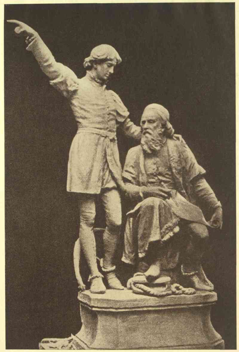
JOHN CABOT AND HIS SON SEBASTIAN
From the model by John Cassidy
Residing at Bristol in 1493 was a fellow-countryman of Columbus, John Cabot, a skilful navigator who, like Columbus, believed in the ‘roundness of the earth.’ He had theories of a road to the East by sailing westward, and considered the moment opportune to urge the king and the Bristol merchants to fit out an expedition.
John Cabot, Giovanni Caboto, Zoanne or Zuan Caboto, was a native of Genoa; the date of his birth is unknown. In the year 1476, after fifteen years’ residence in Venice, he became a naturalized citizen. From Venice he wandered to England, and appears to have taken up his residence in London about the year 1484. In a dispatch of Raimondo di Soncino[1] to the Duke of Milan, dated December 18, 1497, ‘Zoanne Calbot’ is referred to as a Venetian of the lower order, ‘of fine mind, very expert in navigation.’ He had made several voyages to the East, and upon one occasion claims to have been in Mecca, ‘whither the spices are brought by caravan from distant countries, and those who brought them on being asked where the said spices grow, answered that they did not know, but that other caravans come with this merchandize to their homes from distant countries, who again say that they are brought to them from other remote regions.’[2] From this information Cabot argued that he could reach that fertile land by sailing towards the setting sun.
During the winter of 1495-96 Henry VII and his court paid a visit to Bristol and apparently became interested in the project of Cabot, for on March 5, 1496, letters patent were issued in favour of John Cabot and his three sons, Lewis, Sebastian and Sancio. By this instrument they were given ‘authority faculty and power to sail to all parts regions and coasts of the Eastern Western and Northern Sea under our banners flags and ensigns with five ships or vessels of whatsoever burthen and quality they may be and with so many and such mariners and men as they wish to take with them.’ They were also given licence to ‘set up our aforesaid banners and ensigns in any town city castle island or mainland whatsoever newly found by them.’ But the cautious monarch took no financial risk, and the whole enterprise was to be carried out at ‘their own proper costs and charges.’ Moreover they were bound to pay to the king, either in goods or in money, one-fifth of the whole of the capital gained during each voyage.
Although Cabot was endowed with ample authority and had the patronage of Henry VII, there does not appear to have been any eagerness either on the part of the merchants to risk their money, or on the part of the mariners to risk their lives, in the enterprise, for in May 1497 Cabot found himself with one small vessel, the Matthew of Bristol, manned by a crew of eighteen men. The Matthew set sail from Bristol on May 2 under the command of John Cabot. Among the crew was Sebastian Cabot, who also accompanied his father on his second voyage, and who later became the most distinguished navigator of his time in Europe. The objective point of the voyage was Cathay, where was the city of Cambaluc, the residence of the Grand Khan. ‘And having passed Ireland, which is still further to the west and then shaped a northerly course, he began to navigate to the eastern parts, leaving (during several days) the North star to the right; and having wandered about considerably, at length he fell in with terra firma’ on June 24. The exact place where Cabot landed is not known, and the natural desire to locate it has given rise to much controversy. From the La Cosa map and the map of Sebastian Cabot it appears to have been a point on the coast of Cape Breton.
After he had set up the royal standard and the flag of St Mark, for which he had no warrant, he took possession of the land in the name of King Henry VII. The climate pleased Cabot greatly, and he believed he had reached the north-eastern extremity of Asia, whence came the silks and spices which he had seen at Mecca. No people were visible, although, from the fact that snares were set for game and some trees notched, he knew the country to be inhabited. It is interesting to note in connection with this voyage that the English took formal possession of a part of North America thirteen months before Columbus beheld the mainland of the continent at Venezuela. Cabot was ill equipped for a lengthy sojourn in the ‘New Land’ even if he had been inclined to tarry, and having taken wood and water on board he prepared for the return voyage. To Cape Ray he appears to have given the name of St George’s Cape, and St Pierre and Miquelon and Langlade he named the Trinity group. The homeward passage was made without difficulty, and on August 6, 1497, the Matthew dropped anchor in Bristol harbour. Cabot repaired at once to court, where he received an enthusiastic welcome and a gift of ten pounds for having ‘found the new isle.’ Although this reward seems to be trivial, the purchasing power of ten pounds at that time was far greater than it is to-day.
The sovereign was evidently pleased with the result of the voyage, and promised a large fleet for the expedition to Cipangu in the spring. Meanwhile, on December 13, 1497, the king, by letters patent, ‘For certaine considerations us specially moevying have yeven and graunted unto our welbiloved John Calbot of the parties of Venice an annuitie or annuel rent of twenty poundes sterling.’
With money at his command Cabot seems to have bestowed some care on his personal appearance, and a part of the king’s bounty was expended in the purchase of a silk doublet and hose. Arrayed in these he was made much of by the merchants of London during the winter of 1497, ‘nor does my Lord the Admiral esteem himself less than a prince.’[3]
In the meantime he was active and diplomatic in securing a crew for a second voyage. To a Genoese barber he promised an island, while several poor Italian monks were promised bishoprics.[4] The king also appears to have assisted in this work by gifts of money to some of those who agreed to accompany Cabot.
On February 3, 1498, letters patent were issued in favour of John Cabot for his second voyage. In this document Cabot was given authority to take six English ships; but when the expedition sailed early in May it consisted of two ships with a crew of three hundred men. Several vessels accustomed to trade with Iceland appear to have accompanied the ships, but not as a part of the expedition. The voyage was a stormy one, and one of the small vessels which sailed with the fleet was forced to return. At length, early in June, Cabot sighted the east coast of Greenland, which he named ‘Labrador’s Land.’[5] To a man in search of a passage to that elusive land whence came the silks and spices to the mart of Mecca the appearance of this barren coast must have been a keen disappointment, and it is not surprising to learn that on June 11 the crews mutinied and refused to proceed farther north. Cabot was therefore obliged to alter his course and seek for an opening farther south.[6] On reaching the east coast of Newfoundland ‘great plentie of beares was found which use to eat fysshe: for plungeinge theym selves into the water where they perceve a multitude of these fysshes to lye, they fasten theyr clawes in theyr scales and so drawe them to lande and eate them.’[7]
The details of the voyage are fragmentary, but we learn that after proceeding along the coast of Nova Scotia and New England and reaching the parallel of 38° near Chesapeake Bay, the vessels shaped their course for England, where some of them probably arrived in the autumn.
The fate of Cabot is unknown. His grave remains unmarked. The pension of £20 from September 29, 1497, to September 29, 1498, and from 1498 to 1499 was drawn from the Treasury, but whether by himself or by his heirs there is no evidence. It was not a pleasing story that he could relate, only a record of failure and disappointment; for honest endeavour uncrowned by success appeals not to the soul of commerce. Nevertheless the discovery of a narrative of this voyage from his pen would be regarded as a national treasure. Cabot’s work was not in vain. By his discovery of the mainland of North America he brought glory to the English name, and posterity has not been unmindful of his memory.
|
Cited in Biggar’s Precursors of Cartier, p. 17. |
|
Ibid., p. 19. |
|
Biggar, Precursors of Cartier, p. 21. |
|
‘I have also talked with a Burgundian, a companion of Master Zoanne’s who confirms everything and wishes to return there because the Admiral (for thus Master Zoanne now styles himself) has given him an island; and he has given another to a barber of his from Genoese Castiglione, and both of them consider themselves counts, nor does my Lord the Admiral esteem himself less than a prince. I think that on this voyage will also go some poor Italian monks who all have promises of bishoprics. And having become a friend of the Admiral’s, if I wish to go I should have an archbishopric.’—Ibid. |
|
João Fernandez, called llavrador, who made his way from Iceland to Greenland about 1492, was the first to tell Cabot of this country. Biggar, Precursors of Cartier, p. 12. |
|
Biggar, Precursors of Cartier, p. 14. |
|
Ibid. |
In the year 1497 Vasco da Gama rounded the Cape of Good Hope and reached the East Indies. Three years later Pedro Alvarez Cabral discovered the coast of what he believed to be a vast continent and named it Terrae Sanctae Crucis; this afterwards proved to be Brazil. But these achievements did not satisfy the ambition of the Portuguese. King Emmanuel, like all other men in Europe at that time interested in maritime enterprise, believed that a passage to Cathay would be found in the northern part of the New Land across the Atlantic. Moreover, he was jealous of the prestige gained by Spain and England through the discoveries of Columbus and Cabot. At this time there lived on the Island of Terceira a nobleman named João Corte Real, and his three sons, Vaasqueanes, Miguel and Gaspar, each of whom was an experienced mariner, ambitious and daring. Gaspar Corte Real, who at his own expense had made efforts to discover new lands, was now willing to continue his exploration, and the king, anxious to recognize his services, granted to him ‘by right heredity for ever, the governorship of any island or mainland’ he might discover. Accordingly he set sail with two ships from Terceira in the spring of 1500 under a commission from the king dated May 2 in the same year. Proceeding in a north-westerly direction he sighted the west coast of Greenland in June. By the end of the month the vessels were stopped by the ice-fields and he was obliged to head to the south. After leaving Cape Farewell he made for the south-west coast of Greenland, and a little later sailed for Lisbon. Corte Real made a report to the king of his explorations in Greenland. He made observations on the customs of the people and noted the peculiarity of their dwellings, although unable to land in many places on account of the ice. He was by no means discouraged, and made preparation to continue his quest in the following spring. On May 15, 1501, Gaspar Corte Real sailed from Lisbon on his last voyage. The expedition consisted of three ships, two of which reached Lisbon in safety in the month of October; but the ship of Gaspar Corte Real never returned to port. It appears that after cruising about Labrador and sailing up one of the inlets, where they captured a number of Indians, they rounded Cape Race and followed the southern shore of Newfoundland to Placentia Bay. In one of the harbours near that place the ships parted company, and Gaspar Corte Real remained to continue his explorations.
The failure of Cabot to find a pathway to the enchanted land had checked the enthusiasm of the Bristol merchants for adventure. However, on March 19, 1501, Henry VII granted letters patent to Richard Warde, Thomas Ashehurst and John Thomas of Bristol, merchants, and João Fernandez and Francis Fernandez and João Gonzales of the Azores, to undertake exploration in the West. The result of the expedition is unknown; but on December 9, 1502, the king granted to ‘our well beloved subjects Hugh Elyot,[1] and Thomas Asshehurste of our town of Bristol, merchants, and to our well beloved John Gonzales and Francis Fernandez, Esquires, full and free authority faculty and power to transport themselves to all parts, regions and territories of the eastern, western, southern, arctic and northern seas.’ In an extract from the privy purse expenses[2] of Henry VII between 1502 and 1506, various sums are credited to men who have been to the new land, for example:
| To the men of Bristoll who founde Thisle | £0 | 100 | 0 |
| To Clays goying to Richemount with wylde catts and Popyngays of the Newfound Island for his costs | 0 | 13 | 4 |
| To a preste that goith to the newe Llande | 0 | 40 | 0 |
| To the merchants of Bristoll who have bene in the newe founde Launde | 20 | 0 | 0 |
Some of these items were probably paid to men connected with voyages under the letters patent alluded to, but no other reference to them has been found.
In the meantime Miguel Corte Real, believing his brother to have been lost, organized a search expedition consisting of three ships and sailed from Lisbon on May 10, 1502. A certain district of the coast was allotted to each for its search and all were to assemble in the harbour of St John’s, Newfoundland, on August 20. Two of the vessels met at the appointed place, but the ship of Miguel was never heard of again. After waiting for a considerable time the two ships sailed for Portugal with the melancholy tidings. King Emmanuel was much attached to the house of Corte Real, and when the third brother Vaasqueanes sought permission to organize a search for his two brothers, Gaspar and Miguel, the king withheld his consent, fearing that Vaasqueanes might share a similar fate.
In the year 1520 João Alvarez Fagundez petitioned the king of Portugal for a grant of the islands he might discover ‘within the Portuguese sphere of influence.’ He appears to have explored the coast of Nova Scotia and to have given the name of Freshwater Bay to Chedabucto Bay. He also proceeded as far as Placentia Bay in Newfoundland, claiming the islands between Chedabucto and Placentia Bays. These islands were made over to him by letters patent dated March 13, 1521.
Under the patronage of Francis I four ships sailed from France in 1523 in search of Cathay, under the command of Giovanni da Verrazano, a native of Florence. Heavy weather was encountered and the vessels returned to port. On January 17, 1524, Verrazano sailed in La Dauphine from the Desertas Rocks near Madeira, on his second attempt. After a tempestuous passage of fifty days he reached the coast of what is now North Carolina, skirted the eastern shores of the continent and then directed his course northward. He visited Nova Scotia, Cape Breton and the eastern part of Newfoundland in his efforts to find a passage to Cathay. His search proved fruitless and he reached Dieppe on July 8, 1524.
Under an agreement signed by Charles V on March 27, 1523, Stephen Gomez, a native of Portugal, was appointed commander of a caravel fitted out at the expense of the emperor to discover ‘Eastern Cathay, whereof you have notice and information.’ Gomez sailed from Corunna on August 3, 1524. He was forbidden by the terms of his instructions to enter ‘the limits of the sphere of influence’ of Portugal, and appears to have ‘sailed westward to Cape Breton Island and coasted towards the south.’ He touched at Canso and Halifax Harbour, rounded Cape Sable and entered the Bay of Fundy. Continuing his voyage southward he examined Penobscot Bay, Canso Bay, Boston Bay, Cape Cod and finally reached Santiago in Cuba. Sailing from thence he arrived at Corunna in June 1525.
For a few years exploration in England did not receive much encouragement, and it was not until the year 1527 that the Samson and the Mary of Guildford were fitted out in London to seek for a passage to the region of the Grand Khan. The ships sailed from Plymouth on June 10 under the command of John Rut. On July 1 the vessels separated during a storm near the Strait of Belle Isle and the Samson was never heard of again. The Mary of Guildford steered southward to the harbour of St John’s. From there she sailed southward, meeting in the fishing region about fifty ‘Spanish French and Portuguese vessels.’ The fate of the vessel is unknown. On November 21 a vessel answering her description arrived at St Domingo and requested permission to enter the harbour, which was granted, but a shot was fired from the fort and she put out to sea. Thus another expedition was added to the list of failures.
These are the principal early voyages to North America, but there was another factor at work which must not be passed over. Just as the beaver at a later period in North American history lured the fur-trading explorers to the Rockies, to the Pacific and to the Arctic, so the codfish brought hundreds of mariners annually to the fishing-grounds of the Atlantic coast. These fishermen had been visiting the Banks continuously from 1504, if not earlier, and every important harbour close to the fishing regions was as familiar to them as were the harbours of Europe. Many of these fishermen met savages, and like Cartier, as we shall see later, found them willing to part with their furs, even their clothing of skins, for articles of little value. Thus the fur trade began as an auxiliary of the fishing trade. Walrus hunters, whalers and codfishers plied this trade. The profits to be made from it excited the cupidity of the merchants of St Malo, Rouen, La Rochelle and elsewhere, and after the days of Jacques Cartier several individuals, such as the Marquis de la Roche and Pont-Gravé, and finally the great chartered companies, were granted a monopoly of the trade.
The French, Spanish and Portuguese navigators and the fishermen had prepared the way for Cartier’s explorations. When he sailed for North America to find the South Sea, he could shape his course to well-known harbours over frequented waters. From Greenland to Florida the coast had been thoroughly explored. It was left for him to penetrate the continent, and by his foresight and courage to give France the right to lay claim to the vast territory drained by the St Lawrence and its tributaries.
|
Canadian Archives, Biggar, Bulletin No. 5, p. 81. |
|
Ibid., p. 12. |
In 1533, when Jacques Cartier received his commission to lead an exploring expedition westward, the merchants of St Malo, fearing that the manning of his vessels would rob them of sailors necessary for success in the fishing trade, tried to thwart him in every possible way. He was determined to go into the vague, unknown regions beyond the Strait of Chateau Bay (passer le destroict de la baye de Chasteaulx) and he was not to be thwarted. By the spring of 1534 his ships were ready and his crews collected. He was now in his prime, forty-three years old, bronzed by winds and suns on many seas, hardened by years of buffeting tempests, clear-eyed, clear-visioned, a man to inspire affection and command obedience. Judging from the names that he gave localities visited and sighted, he was, too, a man of imagination and deep religious feeling. When his ships, each of sixty tons burden, were fitted out for the voyage, the crews of sixty-one men, all told, took the oath of obedience before Charles de Moüy, the vice-admiral of France. On April 20 everything was ready, and Cartier set sail and swept out of the ancient harbour of St Malo on what was to be the most important exploring expedition to North America yet taken by a French navigator.
Cartier, who was familiar with the course to the New World, sailed with a favouring breeze direct to Newfoundland, arriving at Cape Bonavista on May 10. Here impenetrable ice retarded the onward journey, and the vessels were forced to sail southward for five leagues to a sheltered harbour which they named St Catherine (now Catalina). Ten days were spent in St Catherine Harbour, busy days occupied in laying in a supply of wood and fresh water and fitting out the longboats. On May 21 the voyageurs set sail and started northward towards Isle des Oiseaux (Funk Island), where they once more encountered vast fields of broken ice. On the island, on the ice about it, in the water, and screaming around them in the air they saw an incredible number of sea-birds. So thick were they on the land, that to the mariners they seemed ‘to have been brought and sown expressly on the island which was about a league in circuit.’ They filled a boat with these birds as quickly as if ‘they were loading stones,’ and ‘salted down ten casks full besides what they ate fresh.’ Cartier speaks of them as ‘apponatz, godez and margeaulx,’ which, from his description, were evidently great auks, long since extinct, guillemots and gannets. He makes no mention of gulls, but possibly thought it unnecessary to call attention to birds so familiar to Europeans. He describes another bird which was undoubtedly the razor-billed auk. Here, too, were seen polar bears, which had evidently swum from the mainland leagues away to prey on the birds. One was as big as a cow and white as a swan. As Cartier sailed from Isle des Oiseaux a bear followed his ship. Boats gave chase and captured it, and its flesh proved ‘as delicate as a two-year-old heifer.’
On May 27 the entrance to the Strait of Belle Isle, known to Cartier as Chateau Bay, was reached, but once more the vessels met ice and experienced stormy weather. They were forced to seek shelter in Rapont Harbour (the present Quirpon). Here they remained till June 9, when they once more set sail westward for la grande baye. They passed Blanc Sablon, named from its white sand, situated at the present boundary between the Province of Quebec and the Labrador coast, and on June 10 reached Port Brest (now Old Fort), a well-known harbour, the name proving that French sailors had already visited these waters and that the strait had been discovered before Cartier ventured through it. Boats were sent out to explore the coast westward. These entered a number of harbours: St Servan, named after a suburb of St Malo, the river St Jacques and St Antoine, and Jacques Cartier Harbour, evidently named by the crew in honour of their leader. This latter place is now known as Cumberland Bay and was Cartier’s farthest on the Labrador coast on his westward voyage.
At St Jacques River the explorers met a large fishing vessel from La Rochelle, which had been seeking Port Brest but had missed it through the ignorance of its pilot. This seems to be evidence that mariners had passed through the Strait of Chateau Bay before Cartier. At St Servan (now Lobster Bay) a cross was set up, and the bleak region, ‘dry and half dead,’ nourishing only moss and stunted thorns, which Cartier thought must have been the land allotted to Cain, was claimed in the name of the king of France.
While on the Labrador coast Cartier met natives. They probably belonged to some wandering tribe from the region south of Hudson Bay, possibly Montagnais of Algonquin stock.[1] They were ‘men of fine stature,’ but ‘indomitable and savage.’ They wore ‘their hair on the top of their heads like a bunch of hay, passing through it a small piece of wood or something similar . . . and they also attached there some feathers.’ They wore skins and ‘painted themselves with certain red colours.’
The desolate appearance of the country so far explored made Cartier despair of success by continuing along its shores, and his boats returned to the ships at Port Brest; sail was set, and on June 15 a southern course was taken to explore the land seen on the south side of the strait. Cape Riche, the first point reached, from its appearance was named Cap Double. For ten days a southern course was kept within sight of land, save when for several days they were driven to sea by a tempest. Names were given to bays and capes and mountains in honour of some saint, or from striking characteristics in their appearance. Granche (Grange) Mountains were so called because of the resemblance of one of them to a farm-building. Islands in the bay, called by the explorer St Julien, were named Les Coulombiers from their resemblance to pigeon-houses. Cap Royal (Bear Head), Cape de Latte (Cape Cormorant), Cap St Jean were all sighted and named as the vessels sailed southward. Off Cape Anguille the course was changed westward, and three islands ‘as full of birds as a meadow is of grass’ were reached. These were the Bird Rocks; there are now only two, but a shallow shows where the third, noted by Cartier, was situated. So plentiful were the wild fowl—auks, guillemots and gannets—that Cartier declares that his crew could have filled thirty boats with them in an hour. The islands were named Isles aux Margaulx. Five leagues farther west the explorers came upon an island two leagues long and three wide, and so fertile that it seemed to them a paradise after the bleak regions they had so lately left. Cartier named it Brion Island in honour of Philippe de Chabot, Sieur de Brion, Admiral of France. Here were large trees, ‘peas as fine as any in Brittany, currants, strawberries, roses, grapes and sweet flowers and grasses.’ A strange animal frequented this island ‘as large as an ox, having tusks like an elephant, and which lives in the sea.’ Cartier enthusiastically declares that ‘one arpent of Brion Island is worth the whole of the New Land.’ While at this spot Cartier conjectured that there might be some passage between the Terre Neuve (Newfoundland) and la Terre des Bretons (Cape Breton). On his return to France from his second voyage he was to sail through Cabot Strait, and thus prove definitely the existence of this passage. When the vessels left Brion Island their course was shaped to the west-south-west. By June 26 North Cape, Great Magdalen Island, was sighted. The western shore of this famous group, the key of the gulf, was examined and the southern coast skirted, and then a south-west course was taken into the unknown; but the crews were soon gladdened by the sight of thickly wooded land with shores and banks of red earth. The island now known as Prince Edward had been reached somewhere near Richmond or Malpeque Bay. A boat attempted to go ashore at the Rivière de Barcques (river of Boats), where several canoes were seen, but a storm forced it to return to the ships. Point North was skirted and the Straits of Northumberland entered. Cartier penetrated the strait until he came within sight of Cape Tormentine, which jutted so far towards the curving island as to give the land the appearance of being continuous. An unbroken wall of forest-clad land seemed to prevent further progress in the course he was taking. He believed he was in a deep bay and named the supposed bay St Lunaire, after a Breton saint whose festival fell on July 1. Cartier now crossed to the western shore, visited the mouth of the Miramichi River, skirted northward past Shippegan Island and Miscou, and then turned into a broad bay, called by the Indians Mowepaktabāāk (the Biggest Bay).
Cartier’s hopes soared high, and the southern headland at the entrance to this bay he called Cape d’Esperance—Hope Cape. The vessels crossed to the northern shore of the bay and came to anchor in la couche St Martin (now Port Daniel), while boats were sent out to examine the bay westward in the hope of discovering a passage leading indefinitely inland. The explorers, somewhat to their consternation, came upon a band of savages—Micmacs—in forty or fifty canoes. Some of these approached one of the boats in seven canoes, but the cautious Frenchmen feared them and fired several shots to warn them away. The Indians were anxious to trade, and on the following day showed by their friendly demonstrations that they had no evil designs. For a few knives and tools, gaudy apparel and trinkets, they parted with all their furs, even their clothing, so that ‘they were obliged to go back again naked.’ Cartier was greatly attracted by the climate and vegetation of the bay, and called it la Baye de Chaleur. To him the country seemed ‘warmer than Spain’ and ‘as fine a country as one would wish to see, level and smooth, . . . no part too small for trees, even if sandy; and where there is a wild weed, which has an ear like that of rye and the grains like oats; there are peas as if sown and cultivated, red and white barberries, strawberries, red and white roses and other flowers of sweet and delightful perfume. There are also fine prairies, fine grasses and lakes filled with salmon.’ The low lands with high mountains in the rear checking the westward exploration of the boats told them there was no navigable river penetrating the land, and the mariners, greatly disappointed, shaped their course eastward around the Peninsula of Gaspe. On July 14 Cartier reached Gaspe Bay, and remained there until the 16th, when a fierce storm caused one of the vessels the loss of an anchor, and compelled both to go up into Gaspe Basin for shelter, where they remained until the 25th of the month. At Gaspe they met a band of Indians differing from those of the Labrador country or of Chaleur Bay. They were of Huron-Iroquois stock, and had come down to the gulf from the region about Quebec to catch mackerel. Their men, women and children were greatly attracted by the strange, bearded white men who had come in huge canoes with wide-spreading white wings.
These natives, writes Cartier, ‘can with truth be called savages, as there are no people poorer in the world. . . . Their whole clothing consists of a small skin with which they cover their loins; they also put old skins above and across their bodies. . . . They have their heads completely shaven except a lock on the top of the head, which they allow to grow as long as a horse’s tail; they tie it to their heads with small leather cords. Their dwellings are their canoes, which they turn upside down, and lie down under them on the bare ground. They eat their meat almost raw, merely warming it over coals, the same with fish.’
The Frenchmen visited their encampment, and the savages welcomed them with dancing and singing and great signs of joy. Small gifts of knives, beads and combs greatly delighted them, and ‘they lifted their hands to Heaven as they sang and danced.’ The squaws, to whom Cartier gave combs and ‘tin bells of little value,’ threw themselves ‘in a heap’ at his feet and stroked his arms and breast, their method of caressing.
At Gaspe Bay Cartier erected a cross thirty feet high, on which he fixed a shield with three fleur-de-lis in relief, above which he cut in large letters the words: VIVE LE ROY DE FRANCE. The chief or captain of the band objected to this cross, fearing that this totem was a means of laying claim to the country round about, but Cartier assured him that he intended to return to the bay, and that the cross was to serve as a guide and mark for his vessels. He distributed more presents and the chief’s fears were laid to rest.
Preparations for sailing were made on July 25. Before leaving Gaspe Bay the French induced some of the Indians to come on board, among them two sons of the chief. These youths, Taignoagny and Domagaya, were induced to sail away with the Frenchmen. Some historians have accused Cartier of kidnapping them; but they were willing captives. ‘We dressed each,’ says Cartier, ‘in a shift, a coloured sack [waist] and a red capo, and we placed a brass chain around the neck of each, which pleased them immensely.’ The skins they had cast off they gave to their comrades, who were no doubt envious of the honour done Taignoagny and Domagaya.
On rounding Gaspe Peninsula Cartier made the same mistake that he had previously made with regard to the Straits of Northumberland. He thought the water between the mainland and Anticosti Island (named by him l’Assumption) a bay, and so he crossed to the island and skirted its shores eastward until he reached the extreme eastern end, then turned westward, and on August 1 caught sight of the Quebec shore. He proceeded along Anticosti as far as North Point. Contrary winds and the swift current retarded the progress of his vessels, and he decided not to pass the strait he had named St Peter’s. He knew the Atlantic well. The autumn gales would soon be raging, and after consulting with his men he decided to return to France. On August 9 the vessels were back at Blanc Sablon. On the 15th they sailed through the Strait of Chateau Bay, and after a stormy voyage reached St Malo on September 5.
Cartier was no doubt disappointed, but he had done a great work. He had explored the Gulf of St Lawrence most thoroughly, and had looked into the mouth of the River St Lawrence. He had no gold or spices or silks to bring back with him, but he had tales of fertile lands, of seas teeming with fish, and of forests rich with timber. From the chief’s sons he had no doubt learned of the mighty Hochelaga—the Indian name for the St Lawrence—of the Great Lakes in which it had its source, and of the mythical province of Saguenay which was for many years to be an ignis fatuus for French explorers.
|
S. E. Dawson, The St Lawrence Basin, p. 131. |
The discoveries in the New World made a favourable impression on the court of France. On October 30, 1534, Cartier was granted a new commission by the king, giving him more extensive powers. He was authorized to equip and provision three ships for fifteen months. From this it may be inferred that he was expected to winter with his crews in the newly discovered regions. The enterprise was strongly opposed by the merchants of St Malo, and not unnaturally, for Cartier was left free to select and equip his own vessels before any ship was permitted to sail to the fisheries of the West.
Early in May everything was in readiness for the voyage. Cartier’s fleet consisted of the Grande Hermine, 126 tons burden, commanded by Cartier; the Petite Hermine, 60 tons burden, commanded by Mace or Marc Jalobert; and the Emerillon, 40 tons, under Guillaume le Breton. A number of French gentlemen accompanied Cartier. The entire company numbered one hundred and twelve persons, among them Taignoagny and Domagaya, who were to act as guides and interpreters.
On May 16 all went to the cathedral of St Malo, where they heard mass and were blessed by the venerable bishop, Denis Briconnet. On May 19 the little fleet sailed under a favouring wind, but a few days later it encountered storm and fog and the ships lost sight of each other. The Grande Hermine reached Isle des Oiseaux on July 7 and Blanc Sablon on July 15. Here she waited for her companions. On the 26th the Petite Hermine and the Emerillon arrived. Water and wood were taken on board, and on July 29 the exploration of the north shore of the Gulf of St Lawrence began. Cartier was a careful navigator, and it is not difficult to trace his course. He examined and accurately described headlands, bays and islands, and, with the help of his soundings, with few exceptions, every place he mentioned can readily be identified. By the end of July the Island of Anticosti was reached, and on August 1, on the north shore, Cartier entered a fine harbour fronted by four islands. On one of these islands he placed a cross to serve as a guide to mariners. In the shelter of these islands, now known as the Mingan Group, he stayed until August 7. When about to pass through St Peter’s Strait he was driven back by contrary winds, and for shelter entered a bay which he called Baye Sainct Laurens (now Pillage Bay). This name was later extended to the Gulf and River St Lawrence. After passing Anticosti the vessel crossed to the Gaspe shore. Here Taignoagny and Domagaya were on familiar ground. According to them the vessels were entering the district of Saguenay,[1] out of which flowed a deep, dark river. Leagues beyond was Canada, where their village nestled in the shadow of a mighty rock, and further still the populous country of Hochelaga. In the narrative of Cartier’s voyage Canada is spoken of sometimes as a district, but more often as a town or village, and this is how Cartier understood the word. For a time Cartier sailed along the south shore, then recrossed to the north side, passed the mouth of the Saguenay with its precipitous cliffs blackening the waters with their shadows, and on to the Isle aux Coudres, which was so named from the hazel-nuts found there. He continued his ascent of the ever-narrowing river till he reached an island, which he named Isle Bacchus, from the wild grapes found there. Before he returned from the second voyage Cartier changed the name of the island to Orleans. In his ascent he was greatly impressed by the numerous whales he had encountered about Anticosti, and by the walrus and beluga catadon or white whales.
On September 8, while the three ships lay at anchor, Donnacona, the Agouhanna or chief of Stadacona, approached with twelve canoes and gave Cartier an enthusiastic welcome. Cartier accompanied him back to his village on the bank of the river that skirted the western side of the rock of Quebec. This river, now known as the St Charles, was by Cartier named the St Croix. Here the visitors were received with dancing and singing and wild gesticulation, which was renewed when their leader distributed among the savages presents of knives and trifling ornaments. Cartier returned to his vessels, which on the following day were brought to the St Croix. A site on the north bank, where the little stream Lairet enters the river, was at once selected for a fort. On the 14th the Grande Hermine and the Petite Hermine were brought into winter quarters in the St Croix, but the Emerillon was left in the Hochelaga (St Lawrence), as Cartier intended to visit the town of Hochelaga at the head of the river.
The Indians of Stadacona tried every means in their power to prevent this visit. They even resorted to a most absurd theatrical display, in which mimic devils figured, to terrify the French into abandoning their plan. But the warning of the Indian god Cudragny, that death menaced the French if they should visit Hochelaga, had no effect. Taignoagny and Domagaya now, instead of a help, became a hindrance. For some unexplained reason they had turned against the French, held aloof from them, and during the entire winter tried to rouse the enmity of their tribe against the men with whom they had spent a year. They refused to act as pilots to Hochelaga, but on September 19 Cartier, with the gentlemen of his company, in the Emerillon and two longboats manned by fifty sailors, began the ascent of the river. When the head of Lake St Peter was reached the Emerillon, on account of the shallow water and uncertainty with regard to the river above, was left at anchor, and Cartier and a part of his company proceeded in the boats to the island (Montreal) on which the town of Hochelaga was situated. They reached the swift waters of St Mary’s current on October 2. The Indians had heard of their approach, and fully one thousand of them—men, women and children, in separate bands—crowded to the shore, dancing, singing, and shouting a welcome. Hochelaga was about five miles away, situated between what is now the main business part of Montreal and the foot of the mountain; and on the following day Cartier and his men journeyed over a well-beaten road to one of the most remarkable Indian settlements of North America.
Hochelaga was a strongly fortified place, surrounded by three rows of palisades. Platforms for stones were ranged along the top of the palisades, and ladders leading to the platforms were placed at intervals. The dwellings within the enclosure were substantial structures, ‘finely and cunningly built.’ They were ‘about fifty paces long and twelve paces broad.’ There were about fifty of them, but each one could accommodate as many people as an average modern apartment block. Round the town was much cultivated land, where golden corn glistened in the autumn sunlight. The inhabitants looked upon the Frenchmen with awe and reverence, and brought their lame and sick, among them their Agouhanna suffering from paralysis, to be touched by Cartier, in the hope that they would be restored to health. The situation puzzled the honest mariner. He was no worker of miracles, but he seized the occasion to read to the natives a portion of the first part of the first chapter of St John and the story of the Crucifixion. After this strange and impressive scene Cartier climbed the mountain, which he named le Mont Royal, and viewed from its summit the distant hills, the flashing waters of the Lachine Rapids, and the Ottawa River, which he was told led to the province of Saguenay, rich in copper, gold and silver, and where men of appearance, manner and customs like the French lived. As the season was getting late he did not attempt to go beyond Hochelaga, but returned to the Emerillon, and was back in the St Croix on October 11. A strong fort had meantime been constructed. It was needed. The Indians were already unfriendly, due no doubt to the plotting of Taignoagny and Domagaya. Careful guard was kept night and day, and attack was thus prevented. From the end of November until April 15 the ships were shut in by ice. The cold was intense, and the Frenchmen, unaccustomed to it, suffered greatly. During the winter scurvy broke out among the Indians and many of them died. It spread to the garrison of the little fort, and soon nearly every man was down with this strange and loathsome disease. At length Cartier heard of a tree, called by him the ameda, a decoction of whose leaves and bark was a sure cure for the disease. This was the balsam fir. Under the influence of a liquor prepared from this tree all the sick were soon restored to health, but not until twenty-five of Cartier’s men had perished. With the return of spring strange Indians of warlike mien were seen mingling with the natives of Stadacona. Cartier feared hostilities and decided to avert danger by returning to France. On May 3 he erected on the bank of the St Charles a cross thirty-five feet high, on which were the words: FRANCISCUS PRIMUS DEI GRATIA FRANCORUM REX REGNAT. He thus claimed the country for France.
The Indian chief Donnacona professed to have visited the rich province of Saguenay, and Cartier decided to kidnap him and a number of other chiefs, who, when they had become familiar with the French language, might give information that would lead to a discovery of this wealthy region. He lured Donnacona, Taignoagny, Domagaya and seven other chiefs on board his vessel, and held them prisoners. He treated them well, and Donnacona does not seem to have been an unwilling captive.
On May 6 the Grande Hermine and the Emerillon set sail—the Petite Hermine having been left behind, not being required owing to the reduced number of the band. On his homeward voyage Cartier sailed direct for Brion Island, skirted the Magdalen Islands and the southern shore of Newfoundland. At St Pierre he met fishing vessels. He rested for a brief space in Renowes Harbour, where he left one of his longboats. He then bade farewell to the New World and reached St Malo on July 6, 1536.
|
The Indians apparently divided the St Lawrence region into four districts. Gaspe Peninsula was known as Honguedo; Saguenay extended from the gulf to Isle aux Coudres; Canada from this island to a point some leagues beyond Quebec; the district thence to the Lachine Rapids was called Hochelaga. The mythical province of Saguenay was at the head waters of the Ottawa and beyond. |
About the time of Cartier’s return to St Malo in 1536, Francis I declared war on the Emperor Charles V. This prevented the French king from devoting his attention to western exploration, and it was not until the Agreement of Nice was come to, making provision for a ten years’ peace, that he could listen to the explorer’s prayers for assistance in extending his discoveries. At length Cartier’s petitions were successful, and he was granted a new commission on October 17, 1540. But court influence was at work, and a court favourite was to take the leading place in the next voyage to Canada; for, on January 15, 1541, a commission was issued giving Jean François de la Roque, Sieur de Roberval, absolute command of the projected expedition.
Roberval was created Lord of Norumbega, Viceroy and Lieutenant-General of Canada, Hochelaga, Saguenay, Newfoundland, Belle Isle, Rapont, Labrador, the Great Bay and Baccalaos. This included part of what is now the United States, Nova Scotia, and New Brunswick, the known islands of the Gulf of St Lawrence, the territory drained by the St Lawrence River, and the Labrador coast. The king granted Roberval money wherewith to equip his fleet, and authorized him to take from the prisons all malefactors condemned to death, save those guilty of treason or counterfeiting. Roberval undertook to settle families in Canada and to build forts. Cartier made ready five ships at St Malo and collected his crews and colonists, many of whom came in chains to the vessels. On account of difficulty in collecting his artillery, powder, etc., Roberval was likely to be delayed indefinitely, and Cartier was instructed to sail to Canada in advance. His ships left St Malo on May 23, 1541. Owing to stormy weather he was a full month in reaching Newfoundland. Cartier waited for a lengthy period in Rapont expecting Roberval, but finally sailed without him for the St Croix, where he arrived on August 23, three months after leaving St Malo.
The inhabitants of Stadacona anxiously inquired for Donnacona and his fellow-chiefs. Cartier told them that Donnacona was dead, but that the other chiefs had married great ladies and were happily settled in France. The Agouhanna who ruled in Donnacona’s place seemed pleased, but the Indians generally doubted the news, and with good reason. Donnacona had indeed died, but all the other Indians taken to France were likewise dead, save one little girl of ten, who had been presented to Cartier by the chief of Hochelay, an Indian village on the St Lawrence where Three Rivers now stands.
Remembering his unpleasant experience on the St Croix in 1535, Cartier sailed past Stadacona and decided to erect a fort about nine miles from the present city of Quebec. There, at the mouth of the Cap Rouge River, he landed his provisions, his furniture and artillery, together with ‘cattle, hogs, and other beasts which we carried for breed in the country.’ A fort was erected on the shore and another and stronger one on the summit of the high cliff. It was late to begin cultivating the soil, but Cartier set his men to work, and soon had an acre and a half ready for seed. He sowed this with cabbage, turnips and lettuce, ‘which grew and sprung up out of the ground in eight days.’ This marks the beginning of agriculture by men of European extraction in Canada. To his settlement Cartier gave the name Charlesbourg Royal. Near Charlesbourg traces of minerals, supposed to be gold and silver, were discovered, and crystals of quartz, which, from their brilliancy in the sunlight, the French thought to be diamonds. After Cartier had everything comfortably arranged at his fort, he sent two ships, under the command of his brother-in-law, Mace Jalobert, and his nephew, Stephen Noel, to France to report his arrival to the king.
On September 7 Cartier ascended the St Lawrence, hoping to discover the province of Saguenay. He reached the rapids above Montreal on September 11 and toiled past two of them. There was another to pass before the river (the Ottawa) leading to Saguenay could be entered, but, as he was told that the river was not navigable, he decided to return to Charlesbourg Royal. Mention is made of an Indian village named Tutonagay at the rapids, but the story of this expedition is silent with regard to Hochelaga. Could the prosperous Indian town which had so aroused the explorer’s enthusiasm only six years before have been swept out of existence by the Iroquois and their allies?
When Cartier reached Charlesbourg Royal he found the situation critical. The Indians were most threatening, and the French during the entire winter were kept on the alert to prevent attack. But there is no reliable information regarding this sojourn in Canada. The colonists evidently escaped the scurvy, but, surrounded as they were by unfriendly Indians, the winter could not have been a pleasant one. In the spring there were still no signs of Roberval, and Cartier made ready to return to France.
During the whole of 1541 Roberval remained in France, and was for a time engaged in making predatory raids on English commerce. He sailed from La Rochelle for Canada on April 16, 1542, with three vessels, but was driven back by stress of weather, and reached St John’s, Newfoundland, only on June 18. Here he found seventeen French and Portuguese fishing vessels. On July 9 Cartier entered the harbour on his return from Charlesbourg Royal. He showed Roberval specimens of the diamonds and gold he had found, and the latter was ‘tried in a furnace and found to be good.’ Roberval ordered Cartier to return, but, according to the narrative of this expedition, ‘he stole privily away,’ in order to have ‘all the glory of the discovery of these parts.’ This seems doubtful. Cartier had waited for over a month for Roberval in Rapont; he had sent back vessels from Charlesbourg Royal, with regrets at Roberval’s non-arrival, and it was not like him to refuse obedience to a superior officer. Moreover, he had made no new discoveries save the questionable diamonds and gold, and he had nothing glorious to report to the king.
Roberval spent a week in St John’s Harbour, then sailed round the north of the island, where he is said to have marooned his niece, her lover and nurse on an island—a story of doubtful authenticity. He arrived at Charlesbourg Royal about the end of July, and at once landed his stores and colonists. He named his settlement France Roy or Françoys Roy, and called the St Lawrence France Prime; and sent back his lieutenant, Paul d’Auxillon, Seigneur de Saineterre, to report to the king, and to bring back supplies in the following year. He was in charge of an unruly colony of men and women and governed them with a severe hand. Michael Gaillon he hanged for theft. John Nantez was ‘laid in irons and kept prisoner.’ During the winter hanging and whipping of both men and women were common, and several men and women were shot for insubordination. Scurvy visited the settlement and some fifty died from this disease.
On June 5, 1543, Roberval ascended the St Lawrence in search of the province of Saguenay. He returned from his fruitless quest towards the end of July. During the summer Saineterre was dispatched by Francis I to bring back Roberval, and must have arrived at the settlement not later than the beginning of August, for both Saineterre and Roberval were back in France before September 11. Cartier could not have accompanied Saineterre on this voyage, as the records show that he was in France in March, April and July 1543.
The fishermen and fur traders continued to visit the St Lawrence, and gradually the possibilities of the region impressed themselves on French mariners and merchants. At length a man was found who had confidence in the country. Champlain was to be the true founder of New France. By his dogged determination, daring and diplomacy he was to succeed where Cartier and Roberval had failed.

Cartier’s voyages to the St Lawrence had become, in the beginning of the seventeenth century, little more than a memory, so that when Samuel Champlain began his explorations in North America he was entering what were practically new fields. When Champlain made his appearance on the St Lawrence in 1603 as a member of Pont-Gravé’s expedition, the Huron-Iroquois race, which inhabited the region in Cartier’s time, had disappeared from the river, and with it the villages of Stadacona and Hochelaga. Basque and Breton fishermen had visited the mouth of the St Lawrence, and Tadoussac was the chief place of trade. Here, on May 28, a thousand natives, Algonquins, Etchemins and Montagnais, all belonging to the great linguistic family now designated Algonquin, greeted Pont-Gravé’s party with friendly demonstrations. Among them were Indians from Allumette Island on the Ottawa, under their one-eyed chief Tessoüat. Some months later, around the camp-fire, smoking the calumet, the French and savages entered into a formal alliance against the latter’s inveterate foes, the Iroquois, now so named for the first time in history. This alliance had momentous effects upon the course of discovery and exploration in Canada.
Cartier’s Hochelagans could only speak from hearsay of the upper reaches of the St Lawrence, but Champlain’s Algonquins had penetrated to remote regions north and west, and their information was at first hand. They told of Lakes Ontario, Erie and Huron, of canoe routes by the rivers Trent, Oswego and Genesee, of a high cataract at the west end of the lower great lake, and of the portage round it; but Champlain gathered from the savages that little water came over the falls. Clearly then the upper lakes must have another outlet to the west into a northern or southern sea. In his eagerness to believe that he was on a direct water route to Cathay, he understood the savages to say that the waters of the uppermost lake became salty towards the west, but that it was so vast and stormy that no one had reached its western limits. Champlain came to the conclusion that by the river and lake route he would find the outlet to the Western Sea, the goal of all western explorers. Seven years were to pass before he was to have an opportunity to follow up the information he had received from the Algonquins.
In 1608 Champlain founded Quebec. During the first winter the colony was almost destroyed by disease. Of the original twenty-eight settlers but eight survived. The arrival of Pont-Gravé in June 1609, with men and provisions, gave Champlain new courage. Shortly afterwards he set out in a sloop to invade the country of the Iroquois. Joining forces with the Hurons and Algonquins, he led his motley host up the Richelieu River to the lake since called by his name. Near Ticonderoga a war-party of Iroquois was encountered. A short, sharp fight took place on the shore of the lake. Champlain and two French followers, armed with arquebuses, carried death and terror into the ranks of the foe, who were filled with superstitious dread at the noise and execution of weapons hitherto unknown to them. It was an easy victory, but in the end dearly purchased. In this same year the Half-Moon, carrying Henry Hudson and his Dutch sailors, ascended the river which now bears his name to the country of the Mohawks. Following up Hudson’s discovery, Dutch traders settled at Fort Orange (now Albany) and entered into friendly relations with the natives. The Iroquois, exchanging peltry for guns and ammunition, were soon in a position to contend on more equal terms with the French. For nearly a century and a half they exacted fearful retribution for Champlain’s offence. Soldier and missionary, settler and trader, adult and infant, alike fell before the murderous Mohawks, and French scalps adorned many an Iroquois cabin.
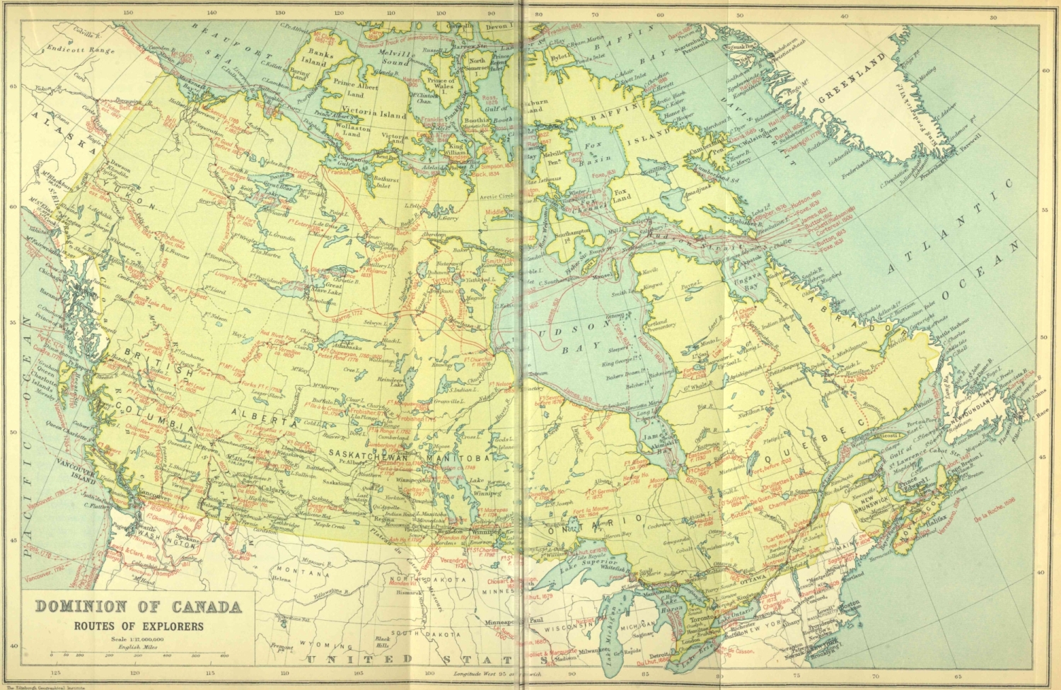
The Edinburgh Geographical Institute
Prepared expressly for “Canada and Its Provinces.”
John Bartholomew & Co.
Near the mouth of the Richelieu River, Champlain again found his allies in 1610, and joined them in an attack upon a hastily constructed Iroquois fort. So complete was his victory that not an enemy escaped. A second time he had cemented with blood the treaty made with the Algonquin fur traders at Tadoussac.
Before returning to Quebec, Champlain effected an exchange of hostages with his allies. A young Huron, whom the French named Savignon, accompanied Champlain to France, while Iroquet, an Algonquin chief, carried back with him up the Ottawa a French youth, Étienne Brûlé, a survivor of the terrible winter at Quebec, who was destined to be the discoverer of a vast territory extending from Lake Superior to Chesapeake Bay. Brûlé was instructed to keep eyes and ears open, and to report to Champlain as to the Great Lakes, the whole upper country, the inhabitants, minerals and everything worthy of note. Brûlé was kindly treated, and when the natives met Champlain and Savignon again below the Grand Sault (Sault St Louis or Lachine Rapids) in the following summer, he appeared arrayed in Huron fashion, and speaking the native dialect fluently. The Indians had given him interesting information. Four of them were present to assure the explorer that they had been to a sea far beyond their country, but the route lay through a region difficult to traverse, and dangerous by reason of warring tribes. The Hurons confirmed the alliance by the usual feast. Three young Frenchmen on this occasion accompanied the savages on their return up the Ottawa, for the purpose of learning their languages and acquiring further information. One of these was Nicolas Vignau, of whom we shall hear again. Champlain promised to return in 1612 and to aid his allies in a long-meditated invasion of Iroquois territory. But his main interest was in the discovery of the Western Sea.
Exploration was costly, and its financial basis was the fur trade. Rival traders were quite willing that Champlain and his associates should take all the risk and bear all the expense of discoveries. When, through his diplomacy and enterprise, the savages descended to the trading-post, they found, in addition to Champlain’s boats, a fleet of vessels awaiting them, sent by adventurers unconnected with the explorer. Champlain saw that success in opening the upper country depended upon monopoly of trade. Returning to France to secure a new charter, he succeeded in interesting members of the royal family. The Comte de Soissons was appointed lieutenant-general in New France, and on his death was succeeded by Henri de Bourbon, Prince de Condé. Champlain was commissioned as the prince’s lieutenant and representative, with full powers for peace or war, to settle with all his people ‘in the place called Quebec, on the Saint Lawrence River, otherwise called the Great River of Canada, in the country of New France,’ and in such other places as he should choose. He was to promote the establishment of religion, to make treaties and encourage trade relations with the natives, to discover and explore regions and rivers tributary to the St Lawrence; and to endeavour to find a feasible route through Canada to China and the East Indies ‘or elsewhere, as far as possible.’ Mines were to be searched out and explored—gold, silver and copper being specifically mentioned. Trading by unauthorized persons was prohibited, under penalty of arrest and transportation to France for trial.
To overcome the traders’ strenuous opposition, permission was extended to all to join the new company. Impatient at delays already experienced, and without waiting to complete the organization, Champlain sailed from Honfleur on March 6, 1613, on his fourth voyage. Arriving at the Grand Sault on May 21, he was disappointed to find only three canoes of Algonquins. He had failed to meet the allies in the previous year according to promise, and they now despaired of his return and had gone off to renew the war with the Iroquois. Meanwhile the traders were waiting at the Sault with large supplies of goods for barter. Champlain resolved to ascend the Ottawa to urge the tribes to come to trade, and to reassure them of his desire to aid them in their wars.
With two canoes, a native guide and four Frenchmen, Champlain set out to explore the great tributary of the St Lawrence. One of the Frenchmen was the youth, Nicolas Vignau, who had gone in 1611 to winter with the Algonquins, and had returned to Paris with a circumstantial story of a visit to the Sea of the North. He reported that in seventeen days it was possible to journey to this sea and return to the Sault. Midway was a lake with an outflow in both directions, on the south into the River of the Algonquins, as the Ottawa was then called, and on the north into the Sea of the North. He had himself seen the wreck of an English ship. Eighty of its crew had been killed by the savages for attempting to take corn and provisions by force; their scalps he had seen. The natives wished to show them to Champlain, and at the same time to present him with an English lad, whom they had preserved alive. ‘This news,’ says Champlain, ‘delighted me very much, for I thought I had almost found what I had long been seeking.’ Hudson’s discovery of the bay called by his name was reported by the mutineers that same year, and fitted in admirably with Vignau’s story. Champlain resolved to visit the Sea of the North for himself.
Setting out from the Grand Sault on May 27, the explorers ascended the Ottawa for twelve days, Champlain making copious notes of rapids, tributaries, islands, portages, flora and human inhabitants. The Falls of the Rideau and the Chaudière Falls in the vicinity of what is now the capital of the Dominion are described at length. At Muskrat Lake, in the present county of Renfrew, reached by a difficult portage after leaving the Ottawa, was a settlement where corn was cultivated. Amazed at Champlain’s success in forcing his way over almost impassable trails, Nibachis, an Indian chief, declared that the Frenchmen must have fallen from the clouds. Tessoüat, the Algonquin chief, dwelt on the south shore of the Ottawa below the present town of Pembroke, and levied toll upon other tribes descending with furs for barter. His village was on Allumette Island. With two canoes furnished by Nibachis, Champlain ascended Muskrat Lake, and by making another portage reached Tessoüat’s abode. His request for canoes and guides to go to the Nipissings to invite them to join in a war against the Iroquois was coldly received. Tessoüat used every argument to dissuade him. The Nipissings were sorcerers, a spiritless people, useless in war; the trails were bad; Champlain would die and Tessoüat’s men as well. Champlain replied by citing Vignau’s experience to the contrary. The now amazed and infuriated savages denounced Vignau as a liar and impostor who had never left the village. The lad’s confession completed the explorer’s disillusionment.
Champlain now had but one desire—to get back to the Sault. First, however, he took formal possession of the country for the king, by setting up on the shore in a conspicuous place a cross of white cedar bearing the arms of France. Other similar cedar crosses were set up at points lower down the river. Scores of Algonquin canoes loaded with furs attended him to the Grand Sault, where traders were waiting with merchandise for barter. Vignau was left at the Grand Sault at his own request. None of the natives would have anything to do with him; and so, says the explorer, ‘We left him in God’s keeping.’ At Champlain’s instance the Algonquins, however, took back with them two young Frenchmen. In this way he was training a band of interpreters, whose services were to be utilized both for purposes of exploration and trading with the various tribes of the upper country. On August 26 Champlain was back in St Malo.
Champlain’s large map of 1612 was the first attempt to delineate the lake region. It sums up Brûlé’s report of his travels on the upper Ottawa, and gives information gathered from the natives. The Ottawa is shown almost to its source, with Lakes Timiskaming and Kipawa, and the rivers Mattawa, Antoine and Jocko. The three upper lakes are combined into one of three hundred leagues in length, only the eastern portion being shown. Various canoe and portage routes appear as rivers. The Trent River is given, rising apparently in Lake Simcoe. The Bay of Quinte and Prince Edward Peninsula are approximately correct. Lake Nipissing has no western outlet, and discharges into the Mattawa, with which also the Trent is connected. Lake Ontario is represented with a length of twenty-five days of canoe travel. Niagara Falls with the Queenston escarpment are shown at the end of a short river connecting the great lake with Lake Ontario. Seven Indian villages are roughly depicted: four on the north shore of Lake Ontario, one probably in Bruce Peninsula, and two between the Trent and Mattawa. To three other regions native names are attached. Manitoulin Island is absent. North of the great lake is a tributary rising in a lake towards the west. The Ottawa and St Lawrence run parallel, at no great distance from each other. South of Lake Ontario, in the country of the Iroquois, are shown the ‘lake of the Irocois’ and several streams. Brûlé had probably been among the Hurons of Georgian Bay, seen Lake Simcoe, and followed the Trent to Lake Ontario, and perhaps gone westward to Niagara Falls. But we can only conjecture as to details.
Champlain’s smaller map of 1613 adds Hudson Bay, gives the name St Louis to Lake Ontario, assigns to the Ochateguins (Hurons) the country between this lake and the Ottawa, and locates the cross planted by Champlain opposite Pembroke to mark his ‘farthest north.’
A small expansion of the Great River in the map of 1612, containing two islands, may have been intended to represent either Erie or St Clair. This shows the vagueness of Champlain’s information respecting the region west of Lake Ontario.
Passing over the portage road from the Ottawa to Mud Lake on his way to Muskrat Lake on June 7, 1613, Champlain lost his astrolabe, an instrument used for taking observations. There it lay undiscovered until August 1867, when it was found in an excellent state of preservation. It bears date 1603, and had probably been carried by the explorer on all his expeditions up the St Lawrence.
Champlain, on his return to France, again encountered much opposition from court intrigues and conflicting interests. Rival ports, St Malo, Rouen and La Rochelle, wrangled over questions of free trade in furs and their shares in prospective profits. These had to be reconciled before he could set out again. It was in the good ship St Étienne that he sailed from Honfleur on April 24, 1615, Pont-Gravé being in command. On the St Étienne were four Récollet fathers on their way to establish the first regular mission in Canada. On his arrival in New France Champlain once more turned his feet westward. At the Grand Sault he found Hurons and Algonquins, who had come down to trade. They were perturbed over Iroquois war-parties, who beset canoe routes and forest trails, and almost paralysed the traffic in furs. His allies reminded him of the aid he had promised them in his last visit. They offered to furnish two thousand five hundred men, and Champlain agreed to assist with as many Frenchmen as possible. The contingent he actually supplied numbered fourteen, including Brûlé, his interpreter.
This alliance determined for a century and a half the history of Northern America. It involved the French in almost continuous warfare with the Iroquois, with hideous accompaniments of torture, massacre, terror and desolation; but it facilitated French exploration and domination of the St Lawrence and Mississippi basins. Its immediate interest to us, however, is in Champlain’s graphic and trustworthy record of his discoveries and adventures in what is now Central Ontario and Northern New York.
Father le Caron and twelve Frenchmen led the way westward, accompanying the Hurons back to their country. Champlain followed on July 9, 1615, with Brûlé, a servant, and ten Indians, in two canoes loaded to their capacity. Setting out by way of Rivière des Prairies below Montreal, they paddled up the Ottawa to its junction with the Mattawa, ascended the Mattawa to Lake Nipissing, and descended French River to the Lake of the Attignaouantans (a Huron tribe), now Georgian Bay.
At the mouth of French River, Champlain was able to add maize and squashes, as well as berries, to his scanty supply of food. Here also he met three hundred men of the tribe called Cheveux Relevés, or Staring Hairs, better known afterwards as Ottawas, who had come, as the natives do to this day, to dry blueberries for winter use
After threading the countless islands of Georgian Bay, Champlain crossed the mouth of Matchedash Bay, and on August 1 arrived at the Huron village of Otoüacha, somewhere near the present town of Penetanguishene—a beautiful region, cleared and settled, diversified with hills and rivers, in pleasant contrast to the barrenness of the country he had passed through. The Hurons were a sedentary race, cultivating the soil and depending largely upon its products for their subsistence. Their dress was of deer and beaver skins, procured from Algonquins and Nipissings in barter for maize and cornmeal. Indian corn was already far advanced. Squashes and sunflowers were abundant. Villages were numerous, there being more than thirty. All the natives gave him a friendly welcome. At Carhagouha he found Le Caron and the Frenchmen who had accompanied him. The principal town, Cahiagué, probably near the present village of Hawkestone on Lake Simcoe, contained two hundred capacious cabins. Here the army which was to invade the Iroquois country was to gather.
Leaving Cahiagué on September 1, the expedition proceeded three leagues to the Narrows, between Lakes Simcoe and Couchiching. Here it was decided to send Brûlé with twelve stalwart savages to the Carantouanais, otherwise known as Andastes or Eries, dwelling on the upper waters of the Susquehanna, to arrange for a junction of their promised force of five hundred men with Champlain’s army. It was a difficult and dangerous journey through hostile tribes. Brûlé and his men, if they took the shortest route, would, after leaving Lake Simcoe, follow the Holland River as far as it was navigable, and then portage across to the Humber. After reaching Lake Ontario, and following its shore line to Niagara, they would avoid the Seneca villages by taking a southerly course to their destination.
Champlain’s route lay along the east shore of Lake Simcoe to Talbot Creek, whence a portage of ten leagues led to Sturgeon Lake. Here the army embarked and paddled down the Trent River with its chain of lakes and streams to the Bay of Quinte, varying the journey by portages round five rapids. The beauty and fertility of the region, and the parklike appearance of the forests, attracted Champlain’s notice.
The expedition crossed Lake Ontario southward at the eastern end, entered the territory of the Iroquois in what is now Northern New York State, and attacked a stronghold of the enemy near Oneida Lake. The attack was unsuccessful; Champlain was wounded, his undisciplined forces showed much valour and little discretion, the Carantouanais failed to appear, and it was necessary to abandon the undertaking. The retreat was effected in excellent order. Champlain’s request for a canoe and men to conduct him down the St Lawrence to Quebec was evaded by his wily allies, who desired to have him present at their council meetings to determine their future action. Near the present city of Kingston they spent some time hunting. With the aid of large enclosures prepared for the purpose, they captured one hundred and twenty deer in five or six weeks. During this time Champlain had a perilous adventure while hunting. Following a strange bird of curious plumage, he was lost in the woods for three days before he discovered the smoke of his hunters’ fires. The Hurons had been greatly alarmed for his safety, and thereafter Darontal, his host, refused to allow him to hunt without an experienced guide.
The homeward journey to the country of the Hurons was full of discomfort and difficulty. Owing to a thaw, the ice was unsafe; yet they were obliged to journey across lakes and streams, and to plunge through great swamps encumbered with fallen trees. By December 23 they were back in Cahiagué.
In January Champlain visited the Tobacco Nation or Petuns, west of the Nottawasaga River. These were a settled race, who cultivated maize as well as tobacco. He was well received and feasted, and won a promise from them and from seven other villages of their neighbours and allies to come in large numbers to trade with the French. Farther west, in the Bruce Peninsula, he found his former acquaintances, the Cheveux Relevés, who also agreed to come to trade.
Two or three days’ journey southward lay the country of the Neutrals, great warriors and tobacco-growers. Champlain desired greatly to visit the Neutrals, but was dissuaded by his hosts. Returning to the Hurons, he went on to the Nipissings, who had promised him aid in his further plans and explorations. He was recalled, however, by a bitter quarrel between the Hurons and Algonquins. An Iroquois prisoner in the hands of the former had been killed by an Algonquin. The Hurons had taken prompt vengeance on the slayer, and in the conflict which followed Iroquet, the Algonquin chief, had been wounded, and Algonquin wigwams plundered. Iroquet had gone so far as to give wampum to the Nipissings to induce them to refuse to accompany Champlain on his proposed journey. Once more the explorer was doomed to disappointment; for the Nipissings traded as far west as the country of the buffalo, forty days distant, and he had hoped with their assistance to make important discoveries.
After a brief sojourn among the Hurons, Champlain, accompanied by Le Caron and Darontal, set out for his little settlement at the foot of the Grand Sault, which he reached in June 1616, bringing with him a mass of valuable information. His recorded observations with regard to the tribes visited have a wide range, including manners and customs, industries, religion and government, hunting, fishing and agriculture.
He had explored the Ottawa-Nipissing canoe route to the Huron country; Lake Simcoe and the Trent River, the eastern portions of Georgian Bay and Lake Ontario; and the counties of Simcoe, Grey and Bruce. He had kept his promise to the Hurons and Algonquins, and confirmed them in their alliance with the French. He had established friendly relations with the Nipissings, Petuns and Ottawas, and secured their trade. He had learned something respecting the Neutrals, the Mascoutens, and remote western and southern tribes. Earlier reports of the immensity of the western territory had been verified by his inquiries. He had failed, it is true, to find the Western Sea, but he had laid the foundations for future discoveries, by making the Hurons’ country the base of operations for missionaries and traders. Here in the school of experience adventurous young Frenchmen were to be trained as guides, interpreters and coureurs de bois, and were to extend his discoveries, and to carry French influence and commerce to remote regions. But his own exploring days were over.
At Sault St Louis, as the Grand Sault was now called, Champlain had a joyful meeting with Pont-Gravé, recently arrived at Quebec from France, and with the Récollet fathers who had remained at the settlement. Proceeding to Quebec, he observed with satisfaction the results of his agricultural experiments. His wheat had prospered, as well as Indian corn and a variety of vegetables; grafts and trees brought from France were thriving.
Meanwhile, what had become of Brûlé? As far as it lay within his power, he had succeeded in his mission. In the Seneca country his band had surprised a small company of the enemy, killed four and carried two as prisoners to Carantouan, chief town of the Carantouanais on the upper Susquehanna. Welcomed with feasting and dances, Brûlé waited impatiently for the termination of the festivities. At length he set out with five hundred warriors to join Champlain. When, however, the hostile town was reached he found the siege raised and the besiegers gone. The promised aid had arrived two days too late.
After wintering at Carantouan, Brûlé descended the Susquehanna as far as Chesapeake Bay, the first of Europeans to do so, although the bay itself had been discovered by Captain John Smith some years before. His hosts supplied him with guides to return to the Huron country. Captured and tortured by the Senecas, he was released through what he believed a miraculous interposition of Providence. An Agnus Dei, which he wore next his skin, had been taken from him, notwithstanding his warning that it was a great medicine and would surely destroy them. Just then a terrific thunderstorm burst suddenly over the terrified savages. Believing him endowed with supernatural powers, they unbound him and made amends by entertaining him with feasting and dancing. They became his fast friends, and actually escorted him four days on his way to the Hurons. We next hear of Brûlé at the St Louis Rapids in 1618, when Champlain took down from his own lips the story of his adventures, and urged him to return to the Hurons and continue his discoveries.
His achievements, important as they were, may be summarized in a few words. He was the pioneer explorer of the Province of Ontario, including Georgian Bay, the countries of the Hurons and Neutrals, and Lake Ontario, as well as the first to explore Northern New York and the Susquehanna River. He was the first white man to gaze on the rapids at Sault Ste Marie and to visit the coppermines of Lake Superior. Among the discoverers and explorers of the upper St Lawrence basin he ranks first in time and one of the first in performance, as he was also the first of those Frenchmen who settled among the native tribes as resident interpreters and fur traders. Parkman had good warrant for describing him as ‘that pioneer of pioneers, Étienne Brûlé, the interpreter.’ His end was tragical enough. After piloting the English to Quebec in 1629, and serving them during their occupation of Canada, he returned to the Huron country, and was clubbed to death and eaten by the Hurons at Toanché in 1632.
The Récollet mission to the Hurons had been a spasmodic affair, but full of historical interest. Champlain’s party, as has been already stated, overtook Father Joseph le Caron’s at Carhagouha somewhere south of Thunder Bay, on August 12, 1615. It was a typical Huron village, with a triple palisade thirty-five feet in height. Here was celebrated the first mass held in what is now the Province of Ontario. All united in singing the Te Deum Laudamus, and this was followed by a salute from their guns. The scene was one calculated to impress the imagination: the palisaded village in the midst of cornfields, framed in by hills and primeval forest; the devout Récollet elevating the Host; the kneeling worshippers; the bronzed face and stalwart figure of Champlain; the lithe, youthful form of Brûlé the interpreter; the little force of soldiers which represented the might and majesty of imperial France. Round these, in picturesque garb of deer-skin and beaver, with plumed head-dresses hanging low on their backs, squatted hundreds of painted Hurons, gazing through the smoke of their long pipes in silence and stolid wonderment.
It was on this occasion that Champlain erected a cross, with the royal arms attached, in token that the country of the Hurons was now added to the dominions of King Louis XIII.
Father Joseph le Caron accompanied Champlain to Quebec, and the mission existed only in name for the next six years. Father Poullain wintered among the Nipissings in 1622. The Huron mission was revived in 1623; Le Caron was accompanied by Father Nicolas Viel, a lay brother named Gabriel Sagard, and two donnés, or lay members, to serve as acolytes and domestics. With them Champlain had sent eleven other Frenchmen, ostensibly as an escort and ‘to support and defend the Hurons,’ but doubtless to act as fur traders as well. On arrival, they found five or six of their fellow-countrymen still living with the savages, and occupying Le Caron’s old cabin. This, the first dwelling erected by Europeans in Ontario, was a hut built in Indian fashion, twenty-five feet by twelve or fifteen, and partitioned into three rooms. Into the outer apartment, which was at once kitchen, dormitory and reception-room, the savages were admitted when they came to visit. This opened into a central room, which served as pantry, storehouse and refectory. The innermost room of all served as a chapel, which none but Frenchmen were allowed to enter. Le Caron and Sagard merely wintered in the mission. Father Nicolas Viel, while returning to Montreal in 1625, met his fate in the Rivière des Prairies. The Hurons in his canoe threw him overboard, and he was drowned in a part of the river which to this day is called Sault-au-Récollet, in memory of his tragic end. Father de la Roche d’Aillon, who arrived in 1625 and remained until 1628, visited South-Western Ontario. He was the first to describe from personal observation the Neutrals and their country. Two Jesuits, Brébeuf and de Nouë, arrived in 1626 among the Hurons. Both returned to Quebec in 1629 before the surrender of the colony to English invaders.
Canada was held by the English until 1632, when it was restored to the French. This year was signalized also by the publication of two important works: The Great Journey to the Country of the Hurons by Brother Gabriel Sagard, and the complete edition of Champlain’s Travels in Western New France called Canada, including discoveries from 1603 until 1629, with his large map summing up these discoveries.
Georgian Bay is shown on Champlain’s map as emptying into Lake Ontario by a short river with two slight expansions. The Falls of Niagara are at the entrance into the lake. The rapids of St Mary’s River are shown. Manitoulin Island was apparently unknown. Although the east end of Lake Superior is outlined, the island with the copper-mine is shown in a smaller lake to the north, which discharges below the Sault into the main stream of the St Lawrence. Flowing northerly into Lake Superior is a ‘Great River coming from the South.’ The Neutrals are shown south of the lakes—a manifest mistake. Dotted lines indicate trails; one leads from Lake Ontario to Oneida Lake, another to the Andastes by a long route starting midway on the river connecting Georgian Bay with Lake Ontario. The map shows clearly Champlain’s own explorations, and indicates his understanding of Brûlé’s discoveries.
Jean Nicolet was about twenty years of age when he came to Canada in 1618. He spent two years on the upper Ottawa and Lake Nipissing among the Algonquins, learning their language and ways, and sharing in their expeditions and privations. For two years he saw not a single Frenchman. Once he went with four hundred Algonquins on an embassy to the Iroquois country, and succeeded in effecting a temporary peace. During the English occupation he remained among the savages. On the return of Champlain, Nicolet reappeared at Quebec, only to receive the governor’s orders to continue the work of exploration. He set out with Brébeuf in 1634 for Georgian Bay. Parting at Allumette, they met once more in the Huron country. When he again turned his face westward he was accompanied by seven Hurons. His instructions were to establish friendly relations between their nation and the Gens de la Mer, otherwise known as the Puants or Winnebagoes, who then inhabited Green Bay. Plying their paddles along the north shore of Georgian Bay, the explorers at length reached the Falls of St Mary, where they rested for a short time at an Indian village. Then they proceeded westward to Michilimackinac and Green Bay. Nicolet was, as far as is definitely known, the first European to enter Lake Michigan, although it is possible Brûlé may have been there before him. The Gens de la Mer occupied the territory between Green Bay and Lake Winnebago. They welcomed their strange visitors, especially after they learned that one was a European. They spoke of Nicolet as ‘the Great-Spirit Man.’
Champlain still entertained hopes that China might be reached by journeying towards the west, and Nicolet carried with him a costume calculated to produce the most favourable impression upon an Eastern potentate. According to Father Vimont, he appeared before the admiring savages in a great robe of Chinese damask, embroidered all over with flowers and birds. As he approached the first village he carried in each hand a pistol, which he discharged as he advanced. The women and children fled in terror; never before had they seen a man who carried thunder in his hands. Four or five thousand natives assembled to see and hear the stranger. Every chief furnished a feast. At one banquet not less than a hundred and twenty beavers were served to the guests. At Nicolet’s request the Winnebagoes readily concluded a treaty of peace.
Crossing Lake Winnebago and entering Fox River, Nicolet went on to villages of the Mascoutens, or Fire Nation, and looked out upon boundless prairies. Three days more on the river would have taken him to the sea. So at least he reported. He was in fact within easy reach of the upper waters of the Wisconsin, an important tributary of the Mississippi, but, for some reason unknown to us, he turned back. Had he gone on he might have anticipated by a quarter of a century the discovery of the Mississippi.
He evidently wintered in the region, for he made the acquaintance of many famous tribes, including the Sioux, Assiniboines, Illinois and Pottawatamies.
Nicolet’s exploration, there is little reason to doubt, took place in 1634. We find him back in Quebec in 1635. Shortly afterwards he took up his residence at Three Rivers, then the chief trading post in the colony, where he acted as general agent and interpreter for the trading company. He was drowned in 1642 in an attempt to reach Three Rivers to save the life of an Iroquois who was being tortured to death by Algonquins. A man of exceptional ability and high character, he was held in esteem by Frenchmen and natives alike.
Nicolet’s claim to immortality does not rest upon the discovery of Lake Michigan alone. By establishing friendly relations with the Winnebagoes and Mascoutens, he contributed to the permanent direction of the north-western fur trade to the Nipissing route, and its practical monopoly by the French for a long period.
On Christmas Day 1635 the heroic figure of Champlain quits the stage of action. Soldier, statesman, navigator, explorer, writer, he was not only a great, but, in the light of his age and surroundings, a good man.
That part of the Province of Ontario which lies south of the Maitland and Credit Rivers was occupied during the first half of the seventeenth century by numerous scattered villages of the Neutrals, so called from their taking no part in the continuous warfare between their kindred, the Hurons and Iroquois. Their territory also extended eastward of the Niagara River to the borders of the Seneca country. Its once almost interminable forests, pronounced by Charlevoix the finest in the world, have almost disappeared before the lumberman’s axe. Flourishing cities, comfortable homesteads and rich fields of waving grain or verdant pasture have taken the place of the stately growths of maple, beech, oak, ash, hickory, chestnut, walnut and butternut, interspersed with noble pineries, with which the land was once covered. In most places the change has been effected within the last hundred years. The pioneers of the early part of the nineteenth century found the country in its essential features unchanged from its aspect when Étienne Brûlé first gazed upon it in 1615. The streams with which the territory was plentifully watered teemed with excellent fish. Wild game abounded. Flocks of turkeys were everywhere to be seen in the woods and swamps. At certain seasons wood-pigeons literally darkened the sky in countless millions, while the inland waters were covered with ducks and wild geese. Deer in herds of hundreds were frequently to be seen. Bears, wolves, racoons, squirrels, foxes and lynxes were numerous.
The rich soil of the Neutrals’ country was liberal with its gifts. Nut-trees contributed their products for the sustenance of human life. Vines laden with grapes lined the river banks. Apple, plum and cherry trees showered their fruits in their season. In swamps and burnt woods a variety of luscious berries tempted the palate. With a little cultivation the natives added to their store of provisions tobacco, maize, beans and squashes. They manufactured flint arrow-heads and axes. But beyond all other resources the country of the Neutrals was the land of the beaver. It was the chief hunting ground, and rival nations regarded it long with hungry eyes.
When Father la Roche d’Aillon sought the mission to the Hurons, it was with the purpose of going on to the remotest tribes beyond. Brébeuf and de Nouë accompanied him to Georgian Bay to learn the language and customs of the Hurons. Brûlé’s enthusiasm over the Neutrals’ country proved contagious, and Le Caron urged the already eager d’Aillon to proceed thither. He took with him two Frenchmen, Grenolle and La Vallée. As interpreters and traders they were necessary to facilitate his passage. Leaving the Hurons on October 18, 1626, he took a trail which led through the country of the Petuns. A friendly Petun chief supplied porters for provisions and packs. After sleeping five nights in the woods, d’Aillon arrived on the sixth day at the first village of the Neutrals. Five villages in succession gave him a kindly reception. At the sixth a council was held. At d’Aillon’s instance the natives agreed to make an alliance with the French and to enter into direct trade relations with them. They also assented to his remaining to instruct them in his religion, and adopted him as a member of the tribe. His adopted ‘father’ was Souharissen, head chief of twenty-eight towns besides smaller hamlets. The chief’s reputation and authority were unprecedented. This proud eminence had been won by sheer valour in wars against seventeen hostile nations, from all of which he had brought back scalps or prisoners.
Grenolle and La Vallée returned to the Hurons, leaving d’Aillon alone among the Neutrals. Meanwhile the Hurons had become alarmed. Their profits from the traffic between French and Neutrals would be at an end if the latter traded directly with the French. To prevent such a calamity they circulated among the Neutrals extraordinary calumnies against the missionary. D’Aillon was attacked and, after being robbed of his possessions, barely escaped with his life. In recent years, a silver chalice, whose form and pattern date back to the period of d’Aillon’s visit, was found in a cache near Burlington Bay among numerous Indian relics. It may have been part of the booty carried off by d’Aillon’s assailants.
In his description of the country of the Neutrals d’Aillon waxes eloquent. It was ‘incomparably larger, more beautiful and better than any other of all these regions.’ Why did not the company send Frenchmen there to winter? he asks. They might easily replace the long, difficult, and perilous Nipissing route by a canoe route which would be short and easy. The chief difficulty was the indolence of the Neutrals and their ignorance of canoes. They were hunters and warriors, not navigators. The difference in language was slight; Hurons and Neutrals understood each other’s speech.
Gabriel Sagard sought to bring about peace between the Hurons and Iroquois, as a means of furthering trade and promoting missions. Members of the company, however, frustrated his desire, pointing out that the Iroquois would divert the trade of the Hurons to the Dutch. The logic was invincible. Through the jealousy and fears of rival fur traders, both native and European, the inter-tribal wars went on with slight intermission for a century and a half.
The Récollets descended to Quebec in 1628, hoping to return at an early date. The Jesuits, left in charge of the mission, followed in 1629. Further exploration of the West, delayed by the surrender of New France to the English, was not to be resumed until 1634, and the Récollets were to be excluded from any share in the missions they had established.
This is not the place to describe the work of the Jesuits on Georgian Bay except in so far as it bears on discovery and exploration. Their centre of operations was near the mouth of the little River Wye, where it is crossed by the main highway from Midland, a little north of the expansion called Mud Lake. From this central station of Sainte Marie the devoted ‘Black-robes,’ as they were called by the natives, went forth two by two to open new missions.
Brébeuf and Chaumonot were selected for the mission to the Neutrals—Brébeuf, the elder of the two, on account of his mastery of native tongues; Chaumonot, a young man of twenty-seven, because he was an apt student of languages. As the Neutrals were reckoned at twelve thousand souls, scattered among forty villages, it was proposed to organize the new ‘Mission of the Angels’ with a fixed and permanent central residence, such as Sainte Marie constituted for the Huron missions. Two successive winters, 1639 and 1640, were spent in futile attempts to carry out the plan. The priests passed through eighteen villages, to all of which Christian names were assigned. In ten they sojourned for a time, and preached to the inhabitants, the total number of hearers being estimated at three thousand. The result, however, was disheartening from the missionaries’ standpoint.
The priests adopted d’Aillon’s plan to secure a safe passage, and his experiences were repeated. French traders had travelled freely among the Neutrals. Brébeuf took with him two French domestics, who pretended to be traders. This ensured a hospitable reception for a time, but the friendly attitude ceased the moment the pseudo-traders returned to Sainte Marie. Thenceforth the missionaries were regarded with suspicion and hatred, tempered only by the native dread of Brébeuf’s skill in sorcery. Wherever they went the cry arose, ‘Here come the Agwa; bar your doors!’ Agwa was a name given to their greatest enemies.
Lalemant’s Relation of 1641 gives a detailed account of the mission, and Sanson and du Creux published maps intended to show the extent of the discoveries made. Leaving the last Huron village, the priests slept four nights in the woods. On the fifth day they reached the nearest Neutral village, Kandoucho, to which they gave the name of All Saints. It was probably in the township of Nelson, where, on the shore of little Lake Medad, main trails from all directions met.
The names Niagara, in its original form Onguiaahra, and Lakes Erie and Ontario appear for the first time in the Relations. Three or four Neutral villages lay east of the Niagara, the nearest, Onguiaahra, being situated at the Falls. The five principal Neutral villages were scattered from Burlington Bay to the St Clair and Detroit Rivers. Talbot Road, running nearly parallel with Lake Erie at a distance of a few miles, follows an earlier forest trail. The priests appear to have followed this trail to the chief western villages. The most central village was not far from the Southwold Earthwork in the county of Elgin, a few miles west of St Thomas.
The name given by the Hurons to the Neutrals, Attiwandaronk, or ‘people speaking a slightly different language,’ was also applied by the latter to the former. The people, although neutral in wars, were more inclined to the Iroquois, the stronger party. The three nations were of one stock. The Neutrals were more brutal than other tribes, for they alone burned women prisoners. They differed in manner and customs but little from surrounding tribes. They wore skins, but in a slovenly and indecent manner. Women were more licentious and shameless than among the Hurons. Lunatics were a specially privileged class, indulged to an extreme degree. In their treatment of the dead, the Neutrals were singular. Bodies were kept in the cabins for a long time, until the periodical Feast of the Dead, when, stripped of flesh, the bones were buried in huge pits.
The principal chief was called Tsohahissen (possibly d’Aillon’s Souharissen), a title rather than a personal name. His village was ‘in the middle of the country,’ and the fathers were obliged to pass through many other villages to reach it. As he was away on a warlike expedition when the Jesuits arrived, the attempt to make a treaty failed. The natives would do nothing in his absence, but allowed Brébeuf to preach. Once more, however, as in d’Aillon’s case, Huron intrigues and calumnies blocked the way to direct trade between the French and the Neutrals. The Neutrals were excited to frenzy by continuous rumours of Brébeuf’s malicious sorceries. Colour was lent to these tales by the missionaries’ unusual garb, their gait, their postures and prayers. Breviary, inkstand and writing filled the savage with terror. They threatened to kill and eat their guests.
The mission was a failure. Midway between Tsohahissen’s village and Kandoucho, the disheartened fathers, toiling painfully along the winter trail homeward, were snow-bound at Teotongniaton, in the cabin of a friendly and hospitable native woman. This was Chaumonot’s opportunity. With the aid of his hostess and her children he prepared, during his sojourn of twenty-five days, a comparative dictionary and grammar of the Neutral language in its relation to the Huron. This achievement alone, in Lalemant’s view, was well worth a sojourn of several years in the country. To complete the story of failure, the dictionary itself has since disappeared.
Ten years later the Neutrals were exterminated or dispersed by the Senecas. Numbers escaped to the upper lakes, where we shall hear of them again under the name of Hurons or Wyandots.
The cartographical results of this expedition appear in Sanson’s maps of 1650, 1656 and 1657, and in du Creux’s of 1660. In Jean Boisseau’s map of 1643 the name Lake Erie makes its first appearance, but the lake is wrongly shown as the upper of Champlain’s two slight expansions of the river between Lakes Huron and Ontario. The map of 1650 shows a distinct advance on all predecessors. Lake Erie appears as a great lake, but is unnamed. The Neutrals’ country is indicated. Lake Ontario and the river St Lawrence are named for the first time. Several streams are shown, including the Humber, Grand River, Kettle Creek and the Maitland. Lake Superior is named, and Lake Michigan and Manitoulin Island are charted, the latter unnamed, the former under the designation Lac des Puants (Lake of the Winnebagoes). Only the lower ends of the upper lakes, however, are shown. The Ottawa, unnamed by Champlain, and called in Boisseau’s map of 1643 the River of the Algonquins, is now Rivière des Prairies. A Frenchman named des Prairies had discovered the branch which lies north of Montreal Island, and the name was now extended to the main stream, which for many years was known indifferently by any of the designations, Grand River, River of the Algonquins, or Rivière des Prairies.
In Sanson’s map of 1656 the river now known as the Thames is first indicated. Two Petun and five Neutral missions are shown. All bear saints’ names, and represent important villages.
The enormous profits of the fur trade naturally excited the keenest rivalry between the French of the St Lawrence and the Dutch of the Hudson. The former were favoured by their alliance with the Hurons and Algonquins; the Dutch enlisted the co-operation of the Iroquois, cementing the partnership by the distribution of brandy and fire-arms. The chief hunting-ground for beaver lay north and west of the Great Lakes.
The Nipissing and Ottawa route, the main thoroughfare of native commerce, was controlled by the Algonquins. Other tribes making use of the trade route paid toll to the Algonquin chief at Allumette. The Hurons carried their furs to the French alone. The Neutrals traded with Huron and Iroquois alike, and by Huron and Iroquois alike the attempts of French traders and missionaries to divert the furs of the Neutral country directly to Montreal or Three Rivers were regarded with undisguised hostility. The Iroquois barred the gateway of the St Lawrence, but in any case the Neutrals, not like their northern neighbours expert canoe-men, and perhaps apprehensive of the fate which was soon to overtake them, were unwilling to risk the proposed transference of trade. Determined to secure control of so profitable a traffic, the Iroquois terrorised their rivals by repeated raids, with horrible accompaniments of torture and massacre. The policy developed later into one of ‘thorough.’ The tribes which stood in the way of the desired monopoly were to be annihilated. The Ottawa trade route was to be closed. The French were to be harassed by constant attacks. Scalping parties were to lie in ambush at portages and landing-places.
The programme was carried out with ruthless persistence to its tragic conclusion. Hurons, Petuns, Neutrals and Algonquins shared an equal fate. Those who resisted were slain. Thousands escaped to distant regions, or died of starvation and exposure in their flight. Large numbers were incorporated with the Senecas, making this tribe by far the most numerous of the Five Nations. The torture and massacre of missionaries, which form so stirring a chapter in Canadian history, were mere incidents in the execution of a trade policy which, bloody and cruel as it was, proved effective for a time. The rich beaver grounds of Ontario became the possession of the Iroquois, who resorted thither in large numbers every winter. The territory between the lakes and to the west was depopulated. The trade of the upper country could pass readily to Albany but not to Montreal or Three Rivers. The Iroquois, like the Romans of old in Caledonia, had made a desolation and called it peace.
In 1650 the exiled Petun or Tobacco Indians, and a tribe of Ottawas from Manitoulin Island, reached Green Bay in Wisconsin. Five years later they were on the Mississippi. Then in 1657, still urged by fear of the Iroquois, they moved towards Lake Superior. The Ottawas established themselves at Chequamegon Point, not far from the present town of Ashland; the Petuns sought a home at the head-waters of the Black River south of the Great Lake. Shortly after the expulsion we hear of eight hundred Neutrals at Sault Ste Marie. They joined the Hurons who had taken refuge in that region. The dispersion of the Hurons, Petuns, Neutrals and Algonquins in the territory lying between Lake Michigan, Lake Superior and the Mississippi River was to be an important factor in extending French influence in the Far West.
In 1653 three canoes of Hurons and Ottawas arrived at Three Rivers. To avoid the dreaded Iroquois they had followed the canoe and portage route from the upper waters of the Ottawa to the sources of the St Maurice. Their embassy was for the purpose of renewing trade relations. The French were only too willing, for Montreal had not bought a beaver-skin for a year. In the following year, accordingly, a flotilla of Petun and Ottawa canoes, loaded with furs, descended the Ottawa. Quebec was all excitement over the news they brought of a great river beyond Green Bay, flowing directly into the sea. Two young Frenchmen accompanied them on the return trip to their western home.
A fleet of fifty canoes, loaded with furs, descended the Ottawa in 1656. Each was manned by five canoe-men, most of whom made the trip for the first time. The two Frenchmen were with them, and had brought from Green Bay or picked up on the voyage eastward a body of savages representing many tribes, including Sacs, Pottawatamies, Menomonees of Green Bay, Saulteurs (Ojibways of the Sault), besides Mississagas, Beaver Indians and others from Georgian Bay. Ottawas from Sault Ste Marie were probably leaders of the party. Among the three hundred dusky canoe-men there must have been representatives also of the exiled Hurons and Nipissings. The cargo consisted of furs worth a hundred thousand crowns, not including those belonging to the two Frenchmen, valued at about thirty thousand francs. The names of the Frenchmen are not stated. They may have been, and probably were, Groseilliers and Radisson. Whoever they were, they had accomplished an important work. The canoe route by French River, Lake Nipissing and the Ottawa had been reopened. Most important of all, information of a definite character was now available as to the ‘great river’ of the West, the Mississippi. The Hurons and Ottawas had seen it, the Frenchmen who had spent two years among the savages of Green Bay had perhaps in their wanderings also gazed upon the mighty stream. But seventeen years passed by before the administration of New France chose to follow up this information by sending out official explorers.
The peace effected by the Iroquois with the French did not extend to the native tribes. The trails were still infested by the treacherous foe, and the safety of those descending to trade depended upon their number. The Ottawas controlled the traffic at Sault Ste Marie and the fleets which visited the marts of Montreal and Three Rivers. The great tributary of the St Lawrence, because it was their highway to the trading-posts, was henceforth to be known as the River of the Ottawas, although the alternative and still older name of Grand River was never wholly abandoned.
For missionary zeal fresh fields were opening. The first attempt to send priests was doomed to failure. Two set out in 1656; one was obliged to abandon the enterprise, the other was murdered above Montreal by a Frenchman. The Hurons, with whom the priests travelled, were attacked on the Ottawa by a band of Iroquois under the command of a war chief known as the Flemish Bastard. Meanwhile a small French military colony was established among the Onondagas south of Lake Ontario. In the following year, 1657, it was necessary to reinforce this detachment. The expedition included eighty Iroquois, more than a hundred men and women of the Huron nation, twenty Frenchmen and two Jesuit missionaries. Among the party was Pierre Esprit Radisson, commonly known to history as Radisson. This expedition proceeded by way of the St Lawrence, and made the first recorded ascent of the river from Montreal to Lake Ontario.
The colony was in constant danger of destruction from the Onondagas. However, Major Zacharie Dupuys, the commandant, succeeded in saving his followers by flight, after their treacherous hosts were incapacitated through Radisson’s clever device of an ‘Eat-all feast’ and copious supplies of liquor. The refugees reached Montreal in April 1658.
There are few narratives of more absorbing interest than the Voyages of Pierre Esprit Radisson. Written more than two centuries ago, the manuscripts remained unknown to historical students until the year 1885, when they were published by the Prince Society. Those with which we are immediately concerned are in English of Radisson’s composition, an English so grotesque that it has perhaps no parallel in literature. Imperfect knowledge of the language is manifest in every line; some passages are so obscure as to be almost unintelligible; references to places are at times vague and uncertain; the narrator is careless about dates and sequences; but the story is in its main lines easy to follow.
Nowhere do we get a better insight into savage modes of living; the squalor and misery; the precarious subsistence upon hunting and fishing; the rude agriculture and barter; the alternations of abundance and famine; the tribal rivalries and warfare, with their attendant horrors; the ceremonial of councils, embassies and treaties; the incongruous blending in native character of gentleness and ferocity, of hospitality and treachery. It is, moreover, of unique importance in establishing the claim of Radisson and his brother-in-law, Médard Chouart, Sieur des Groseilliers, to rank among the greatest discoverers and explorers. To them belongs the honour of being the discoverers of the regions bordering on the upper Mississippi. They were the first explorers of the greater part, if not the whole, of Lake Superior and the territory surrounding it. They were the first Europeans to visit a number of north-western tribes, including the Sioux, the Assiniboines and the Crees, and possibly to penetrate to James Bay from the Great Lakes. At a later period, passing over to the service of King Charles II of England, they became important factors in the establishment of the Hudson’s Bay Company, and in the acquisition by Great Britain of the enormous territory draining into Hudson Bay.
Pierre Esprit Radisson arrived from France in 1651 as a lad of fifteen. Two sisters had preceded him to Three Rivers, where he joined them. In the following year, while hunting on the outskirts of the settlement, he was surprised by prowling Mohawks. His comrades were killed and scalped, but Radisson’s life was spared and he was taken to the Mohawk country. Adapting himself to the ways of his captors, he won their affection and confidence, and was adopted into a family of the tribe in place of a son who had been slain. Associated with three savages in a hunting party, he killed his companions and escaped, but was recaptured on Lake St Peter and brought back. After some experience of the tortures to which captives were often subjected, he was saved from death through the efforts of his foster-parents. At last he succeeded in effecting his escape to the Dutch at Albany, and thence to New Amsterdam (now New York) and France. When in May 1654 he returned to Quebec after two years’ absence, he found that he had long since been given up as dead. He learned also that his widowed sister had been married to one Médard Chouart, Sieur des Groseilliers, an experienced and successful coureur de bois.
Groseilliers had come to Quebec in 1641 at the age of sixteen, and entered the service of the Jesuits in the Huron mission. When he left their employment in 1646 he became a fur trader, having qualified himself by a practical knowledge of native languages and tribes, trails and canoe routes. In the following year he married, at Quebec, the daughter of Abraham Martin, the pioneer who gave his name to the celebrated Plains of Abraham. After his wife’s death he married one of Radisson’s sisters. Fur traders by vocation, explorers by choice, the brothers-in-law became partners in exploration as well as business, and at first met with extraordinary success in their enterprises.
It is not an improbable surmise, as already stated, that Groseilliers and Radisson were the two young Frenchmen who spent the years 1654 to 1656 in the North-West. It is certain that the former was among the French traders who returned to Three Rivers from the pays en haut, or upper country, in 1657, with the information that several bands of natives would come with furs for barter in the following spring. When the natives arrived it was determined that they should be accompanied on their return voyage by a large party of Frenchmen, including two missionaries, to influence the tribes to come down the next year in still larger numbers to the trading-post. Groseilliers and Radisson, who had just returned from Onondaga, decided to profit by the opportunity to undertake an independent voyage of discovery. ‘I longed,’ says Radisson, ‘to see myselfe in a boat.’ It was a perilous venture, for the Iroquois were everywhere.
Thirty-one Frenchmen and fourteen natives constituted the expedition. On the Ottawa they overtook more than a hundred natives, whose canoes were laden with merchandise and guns. The combined parties now numbered more than seven score, but the show of strength was delusive. Proceeding in scattered bands without any order or precautions, they exposed themselves to attack with disastrous results. The Iroquois lay in wait for them, and after suffering the loss of four canoes, thirteen men and all their supplies, the French and their allies fled upstream with all possible speed, half-starved, and in their terror paddling both day and night. The missionaries were left to find their way as best they could to Montreal. Disheartened and unable to keep up with the natives, the French canoe-men abandoned the attempt. However, Groseilliers and Radisson, with their swarthy guides, pressed on and reached Georgian Bay in safety. The Sault Ste Marie and north-shore Indians went westward to their destination, while the two adventurers followed the Hurons along the south shore. Passing the devastated Huron country on Matchedash Bay, they observed from a distance large open fields now abandoned. After many days’ travel they reached Manitoulin Island and the villages of their Indian companions.
Paddling on to Sault Ste Marie, the explorers persuaded the Ottawas to make peace with their enemies, the Pottawatamies. The latter came from their homes in Green Bay, and the event was celebrated with the usual feasting. The explorers, accepting the invitation of the Pottawatamies, went to Green Bay to winter with their new allies. In the spring they ascended Fox River and were welcomed by the Mascoutens, who had been recently expelled from the lower Michigan peninsula by the Iroquois. ‘A faire proper nation,’ says Radisson. ‘They are tall and big and very strong.’
Four months were spent by the adventurers in travelling ‘without doeing anything but goe from river to river.’ They became acquainted with numerous tribes. ‘By the persuasions of some of them we went into the great river that divides itself in 2, where the hurrons with some Ottanake [Ottawas] and the wild men that had wars with them had retired.’ In these words, without flourish of trumpets, Radisson announces what was perhaps a momentous discovery. ‘The great river that divides itself in 2,’ was it not the Mississippi River, and Radisson and Groseilliers, were they not probably the first white men, after de Soto, who saw it?
In their desire to ‘travell and see countries’ and ‘to be known with the remotest people,’ the explorers questioned every tribe respecting the regions beyond. Among the most considerable nations, they learned, were the Crees and Sioux, the former being allies and the latter enemies of the Mascoutens. Some Winnebagoes spoke of the Bay of the North (Hudson Bay), and ships with white sails, and men on board. Sault Ste Marie was the central mart for the whole North-West, regarded by the Ottawas as their preserve, but poached on by the Iroquois with varying success. Ottawas and Mascoutens combined to prevent the Crees from trading directly with the French. In barter with their remoter neighbours the Ottawas exhibited a shrewd discrimination. The Crees might purchase hatchets and knives, but not guns. These the Ottawas reserved for their own exclusive use. The Sioux wanted hatchets and knives, and envied their enemies the Crees, who were able to procure these necessaries. There was but one way to remedy the inequality, and that was to make peace with the Crees.
Radisson further ascertained the important fact that the best beaver country was not on the Mississippi, but far northward. His attention therefore was no longer directed to the Great River, and after some exploration toward the south, including part of Lake Michigan, the beauty of whose shores and climate excited his enthusiastic admiration, he and Groseilliers proceeded to Sault Ste Marie in company with Mascoutens going thither to trade.
It was in the autumn of 1659. A war between the Sioux on one side and the Crees and Ojibways on the other had terminated in a great victory for the allies. The explorers decided not to visit the victors, but to winter among the Sioux, with a view to persuading them to make overtures of peace. In this decision they were influenced in part by apprehensions of an attack upon the Sioux by the ubiquitous Iroquois. Why should not the north-western tribes combine against the invaders? By such an alliance the whole stream of traffic would be diverted to the St Lawrence. Other French traders were already at the Sault, and accompanied the explorers on the westward journey. Bands of Ojibways were found along the south shore of Lake Superior. The Ottawas were now settled at Chequamegon Bay near the west end. Six days’ journey southward the Petuns had established themselves, on the head-waters of the Black River, and thither the explorers made their way. Ottawa guides conducted the adventurers to the Sioux of the upper Mississippi, among whom they passed the winter, establishing friendly relations between that nation and the French, and endeavouring to reconcile them with the Crees.
During the spring the two Frenchmen were once more on the shores of Lake Superior. They proceeded by land eastward to Ontonagon River, and then, partly by water and partly overland, southerly to Green Bay. With the Pottawatamies arguments and gifts were in vain. They refused to go to trade, through fear of the Iroquois. The explorers had better success with the Ottawas, Hurons, and lesser tribes, and on July 24, 1660, they set out from Green Bay for the trading-posts on the St Lawrence. The glorious and tragic defence of the Long Sault by Dollard and his handful of heroic young Frenchmen had taken place in May. Dearly as the Iroquois had paid for their victory, the tidings spread terror among the north-western tribes. Of a hundred canoes in all which joined the expedition, each manned by five dusky warriors, no less than forty turned back through fear. Sixty canoes with three hundred warriors, carrying furs valued at 200,000 livres, completed the voyage, which followed the Nipissing-Ottawa route. Skirmishes with the Iroquois both on the Ottawa and St Lawrence added to its perils, but the fleet reached Montreal in safety, and leaving a fourth part of the cargo there proceeded down the St Lawrence to Three Rivers.
Groseilliers and Radisson had been absent for more than two years on this voyage. At Quebec they found three ships at anchor, which but for their coming would have gone back to France without cargoes. The adventurers were received as conquering heroes with thundering of guns from fort and ships. They were entertained by the governor with special marks of favour, and were escorted back to Three Rivers by two brigantines to do them honour. What had they done to deserve such distinguished favour? They had saved the season’s trade. They had discovered the Great North-West. They had defied the Iroquois and established alliances with new and powerful tribes. They had reopened the Nipissing-Ottawa canoe route, and, greatest of all, they had shown the enormous possibilities of this route as the great highway by which the traffic of the vast territory adjoining and beyond the great lakes could be carried to tidal waters.
A new voyage by Groseilliers and Radisson to the upper country was undertaken in opposition to the views of the governor, Baron d’Avaugour, whose demand of half the net profits had been indignantly refused by the explorers. In 1661 they slipped away clandestinely by the favourite Ottawa and Nipissing route. The flotilla numbered fourteen canoes, manned by Ojibways and Nipissings. After the usual experience of bloody encounters, scalping and cannibal feasting, they reached Lake Superior, passed along the south shore, seeing on the way the sand-dunes, the Pictured Rocks, and abundance of native copper. They finally reached Chequamegon Bay. Here the Hurons left the lake for their villages inland, ‘5 great dayes journey,’ and the explorers remained to build a palisaded fort, not far from the present town of Ashland, and to place the bulk of their supplies in safe caches.
Within a fortnight more than four hundred natives had assembled in the neighbourhood. The Frenchmen, reasonably apprehensive of their designs, were probably glad to accept the offer of the Hurons to conduct them southward to their villages. Here there was the usual round of speeches of welcome, feasting and dancing; then all scattered for the winter hunting. Snow fell to a depth of several feet. The woods were impassable. Famine followed, the horrors of which have never been more vividly described than by Radisson. To its miseries was added the terror of war. The Ottawas of Manitoulin Island had quarrelled with the Hurons, and had come to attack the latter in their villages.
During the winter the explorers narrowly escaped death from starvation. With spring came successive embassies from the Sioux, bringing supplies of food. These were followed by a concourse of five hundred natives belonging to eighteen small tribes. The Sioux chiefs went through the grotesque national custom of weeping over the guests. ‘They weeped uppon our heads,’ says Radisson, ‘untill we weare wetted by their tears.’ A new treaty of peace was made with the French, who, however, also insisted upon the cessation of the wars between the Sioux and Crees. A friendly reception was thus assured to the explorers when they visited the Crees at the head of the lake. The Crees, after securing a promise from the Frenchmen to visit them in the spring, returned to their country, which appears to have included all the region north of Lake Superior.
The Frenchmen, however, were under obligation to pay a return visit to the Sioux at Mille Lacs, in the present State of Minnesota. The visit lasted six weeks. They found a town of seven thousand men, who won a miserable subsistence from the soil, the severe cold hindering the success of the crops. Radisson learned that their country contained mines of copper, pewter and lead, besides ‘a kind of Stone that is transparent and tender, and like to that of Venice,’ a manifest reference to red pipe-stone. But the most important information related to the beaver. It confirmed what he had gathered on his previous voyage. While the country of the Crees produced a greater quantity of beaver, the peltry obtained in the northern forests by the Sioux were the finest in the whole world. The adventurers returned to the head of Lake Superior laden with booty, which taxed the energies of their native porters. Spring was approaching, and it was the season for hunting moose. Radisson claims that he and Groseilliers with one Indian guide killed more than six hundred moose besides other game. They built a fort at Chequamegon Point, and found their caches in good condition.
The fur traders crossed the lake, by a traverse of fifteen leagues, and were joyously welcomed by the Crees. They were carried in triumph in their canoes on the shoulders of natives, ‘like a couple of cocks in a Basquett.’ Notwithstanding some difficulties in the narrative, there appears to be little doubt that the two Frenchmen went on to Hudson Bay ‘by the Great River,’ doubtless the Albany. The expedition was a decisive event in the history of the fur trade; for, through the explorers going over to the English at a subsequent period, it led to the establishment of the Hudson’s Bay Company, and the diversion of a great part of the vast northern traffic in peltry from the Lake Superior and Ottawa route to that of Hudson Strait. The monopoly was broken. Henceforth the fur trade and the northern part of the continent were to be divided between the English and the French.
The adventurers returned by another river route (probably Moose River) to Lake Superior and Chequamegon Bay. Crees in four hundred canoes brought them beaver-skins, and a number of them undertook to accompany the traders on their voyage to the St Lawrence. With a fleet of three hundred and sixty canoes, each carrying from two to seven men, the long journey to Three Rivers was begun. About the end of August Three Rivers was reached. The explorers, however, found to their cost that they had not been forgotten by those in authority. Their profit was reduced fully one third by the exactions of the company and the fines imposed by the governor. The treatment they received drove them over to the English, and, as already stated, led in a few years to the establishment of the great English trading organization, the Hudson’s Bay Company.
The Jesuits were the first to publish an account of discoveries in the distant West. Their first mission on Lake Superior was established at Point Keweenaw in 1660-61 by the aged but dauntless Father René Ménard. Endeavouring to reach the Hurons at the upper reaches of the Black River, he lost his way and won the coveted crown of martyrdom by perishing alone in the forests, whether from starvation or by the hand of a murderous savage is unknown.
His place in the missions was soon filled. Allouez followed four years later and founded the new mission of La Pointe at Chequamegon Bay. After another four years he in turn was succeeded by the gentle and saintly Marquette, soon to distinguish himself as an explorer of the Mississippi, and to die like Ménard in the wilderness.
Allouez was able to report to his Superior the existence of the great river, the Mississippi. What had previously been matter of rumour was now a certainty. Neither the Ottawas and Hurons of La Pointe near the west end nor the Ojibways of the east end of Lake Superior offered a promising field to Allouez. He found greater consolation among the Nipissings, a score of whom, after twenty years of exile, still remembered their Christian teaching. The Nipissings he found on Lake Nipigon, a centre of communication and traffic between Lake Superior and the Far West and North.
In 1668 we find Marquette at Chequamegon. In the following year, Dablon and Marquette began a new mission at the foot of St Mary’s Rapids. The spot now forms part of Sault Ste Marie, Michigan. Allouez left La Pointe in charge of Marquette, while he proceeded to found at Green Bay the new mission of St Francis Xavier. Among the dwellers on Green Bay were Sacs and Foxes, Pottawatamies and Winnebagoes. Ascending the Fox River, he visited the Mascoutens, as well as a village of Foxes. All the tribes he had seen were of Algonquin speech, except the Winnebagoes, whose language he found it necessary to master. In 1670 we find him on the Fox River, Lake Winnebago and the Wisconsin, which he reports as leading to the Mississippi, only six days distant. Druillettes and André were sent up to support him in 1670, the former taking charge of Sault Ste Marie and the latter of Manitoulin Island and Lake Nipissing.
The troubles between the Hurons and Ottawas on the one hand and the Sioux on the other culminated in 1670 in the withdrawal of the former from Lake Superior. Marquette accompanied them to the Sault, where they divided, the Hurons with Marquette going to Michilimackinac, while the Ottawas established themselves in their old home on Manitoulin Island. Marquette also had heard of the ‘Mississippi more than a league wide.’ Whither it flowed he knew not, although he had inquired of the Illinois and the Shawnees. He was anxious to sail upon it and solve the great mystery. André’s field included the Mississagas, the Beavers, and certain northern tribes who then wintered on Lake Nipissing, as well as the Ottawas of Manitoulin. The result of the geographical knowledge obtained by these trained observers is seen in the Jesuit map of 1671, which gives an excellent delineation of Lake Superior and the northern parts of Huron and Michigan, including Green Bay and its affluents. It is finished in minute detail, and shows the shores with their numerous indentations and larger islands, and the routes to the Illinois, the Sioux and the Assiniboines.
Towards the end of May 1670, in their mission at Sault Ste Marie, Dablon and Marquette were doubtless surprised, and not altogether agreeably, by receiving a visit from two intruders upon their ecclesiastical domain. Dollier de Casson and René de Bréhant de Galinée, priests of the Sulpician seminary of Montreal, had after a journey of more than ten months, including five months’ sojourn on the north shore of Lake Erie, succeeded in making their way from Montreal by a route hitherto unknown. No white man before them is known to have ascended the lower lakes. Their journey had been full of incident and adventure, with occasional peril from the Iroquois. They had listened to the distant roar of Niagara, penetrated into Burlington Bay, followed the Grand River to its mouth, built at Port Dover the first European habitation ever erected in Southern Ontario, and learned by actual experience the wonderful fertility of the country and its wealth in all kinds of game. Galinée had kept a journal and made a tolerable map of their discoveries. Their expedition begins a new epoch of systematic exploration, directed by the master hand of the intendant of New France, Jean Talon.
In 1663 the charter of the Company of One Hundred Associates was surrendered, and the Crown assumed direct control in New France. Two years before, on the death of Mazarin, Louis XIV had taken the reins of government into his own hands, and Colbert was his principal adviser. In 1665 Jean Talon was sent as intendant to Canada. Talon contemplated nothing less than the establishment of a mighty empire in the western world under the sway of the Grand Monarque. Lawlessness was to be repressed, immigration, trade and commerce to be effectually regulated and encouraged, discovery and exploration to be extended, strategic points to be garrisoned, the English and Spaniards to be shut in to a narrow strip of seaboard, and the rest of the vast continent to be added to the dominions of his sovereign. Factories were to be built, industries established and mines opened. All was to be done under the king’s auspices, and largely at his expense. The Iroquois peril was confronted without delay. Terrified by successive and unexpected invasions, the destruction of Mohawk villages and the erection of French forts at commanding points, the Five Nations were glad to make peace with the French in 1667. The truce lasted twenty years. Lay and clerical elements in the Sovereign Council combined to take advantage of the opportunity.
Heretofore Lake Ontario had been a closed sea, fear of the Iroquois having prevented its use for navigation. No white man is known to have descended the St Lawrence from the lake until 1653, when Father Poncet returned in a canoe by this route, or to have ascended it until 1657, when Father Simon le Moyne’s canoe reached the Iroquois country.
On the north side of the lake Iroquois villages had been established, including one by Senecas and Andastes at the west end, another by Cayugas at the entrance of Weller’s Bay in Prince Edward County. To this Cayuga village, called Kenté, came the Sulpicians in 1668, to open a mission among the ‘Iroquois of the North.’ Talon’s supporting hand is visible in this enterprise. He had arranged with the Sulpicians that their discoveries and explorations should be reported to him. By the end of the following year the north shore of Lake Ontario was fully known, mission stations having been extended by Trouvé westward beyond Burlington Bay. Under the inspiration and example of the governor and intendant, the whole population of New France entered with zest into the great problems of discovery and development of trade routes and the extension of missions.
Laymen and ecclesiastics alike shared in the general enthusiasm. Louis Jolliet, now a young man of twenty-four, was an alumnus of the Jesuit College at Quebec, son of a wagon-maker, with a proclivity for mathematics and surveying. To him and an experienced coureur de bois named Jean Péré was entrusted by Talon and by de Courcelle, governor of New France, the duty of visiting the copper-mine on Lake Superior, ascertaining its value, and finding if possible a cheaper and more practicable way for transportation than the difficult and dangerous Nipissing route. Péré ascended Lake Ontario to Gandatseteiagon, probably near Oshawa, and thence by the portage route to Georgian Bay. With the possible exception of Brûlé, no white man had preceded him on this route. Whether Jolliet followed the same or a different route is uncertain. At Sault Ste Marie they found the Ottawas on the point of burning an Iroquois prisoner. Jolliet persuaded them to forbear, and to send back the captive to his people, as a recognition of the peace. The Iroquois informed him of a canoe route to his country unknown to the French. Grateful for his deliverance, he undertook to guide the Frenchmen over the new course. It was too late for Jolliet to visit the mine, so he resolved to return to Montreal. Péré appears either to have continued his journey or to have been detained at the Sault.
Jolliet and his Indian guide descended the chain of lakes, which no European is recorded to have done before this time. Following the north shore of Lake Erie past the low cliffs to Rondeau, they had still the long reach of high cliffs to pass before reaching the shelter of the Kanagio or Kettle Creek. Danger from prowling Andastes increased as they proceeded eastward, and Jolliet found it necessary to yield to his guide’s apprehensions. Leaving the canoe well hidden at the mouth of Kettle Creek, they followed forest and river trails for a hundred miles, probably along the general course of what are now Talbot Road and the Grand River to a point considerably above Brantford, and thence to Burlington Bay. Reaching Tinawatawa, a Seneca hamlet near the present village of Westover, midway between the river and bay, they met a party of more than a score of Frenchmen carrying seven canoes, and bound for the south-west. This was on September 24, 1669. The party, divided under a double leadership, was united in one common idea, that of reaching the Great River of the south-west. Robert Cavelier de la Salle, in his twenty-sixth year, was the lay chief of the expedition. Dollier de Casson and Galinée, gentlemen of the seminary, led the missionary section. With them were a surgeon and a Dutch and an Algonquin interpreter. It was a remarkable meeting of men destined to write their names in large characters on the pages of North-American history.
In the establishment of missions in New France the Récollets were the pioneers. They were superseded by the Jesuits, who monopolized the burden and the danger, the successes and the failures, for a third of a century. By the year 1669 the Jesuits had two chief missions west of Montreal. At Sault Ste Marie Dablon and Marquette ministered to the Hurons and Ottawas, the Nipissings and the tribes who traded with them, and a mission had been reopened among the Iroquois south of Lake Ontario. The king, however, had decided to give a share in that work to the Seminary of St Sulpice, seigneurs of the Island of Montreal.
In 1668 Abbé de Queylus returned to Montreal as superior of the seminary, and at once entered with enthusiasm into Talon’s plans. A number of priests accompanied him, all eager to devote themselves to the work of their calling. Dollier de Casson was dispatched to Lake Nipissing to winter among the Algonquins and learn their language. Two young priests, Trouvé and Fénelon, the latter a brother of the celebrated Archbishop of Cambrai, were sent to open a mission on the north shore of Lake Ontario. On Weller’s Bay, south of the Isthmus of Prince Edward County now cut by the Murray Canal, some Cayugas had settled during the previous year at Kenté. Other villages had been established along the north shore by the Iroquois. Accompanied by a chief from Kenté and another Indian, the youthful missionaries set out from Montreal, welcoming the hardships of the voyage. To procure food for their subsistence, they stopped at points which offered good hunting or fishing. It was a perilous as well as a difficult journey. There was the ever-present danger from ambushed foemen; it was necessary to be always on the alert for a glimpse of ‘the shaven head and the painted face, and the shot from behind the tree.’ Twenty-six days were occupied in the voyage. The missionaries’ reception at Kenté was hospitable and joyous. It was perhaps the first ‘donation party’ in Ontario. Nothing was too good for the honoured guests. One savage brought half a moose’s carcass. A second regaled them with squashes fried with grease. Another had been fishing with scanty success; he presented his entire catch, a small pickerel. Salt was a rare luxury; but one good old woman in a fervour of hospitality sprinkled a little of the precious article in the priests’ sagamite or corn-meal porridge.
The following year Fénelon descended to Quebec for supplies to recompense the natives for the support of himself and his colleagues. On his return the Senecas of Gandatseteiagon desired a black-robe, and he spent the winter among them. Other villages of the northern Iroquois required missionaries. Ganeraské (near Port Hope), Ganeyous (near Napanee) and Tinawatawa (near Westover) were supplied by Trouvé and d’Urfé in 1669.
To reach Tinawatawa Trouvé necessarily followed the north shore from end to end. No white man before him is definitely known to have done so. To the Sulpicians may fairly be awarded the honour of completing the exploration of Lake Ontario.
A strong effort was made to establish a permanent mission at Kenté. De Courcelle and Talon concurred in a grant of land to Trouvé and Fénelon for building and clearing, with rights of fishing. The seminary in Paris sent labourers to clear the land and artisans to build a mission-house, besides furniture, provisions and implements of agriculture. At great expense oxen, swine and fowls were transported to Kenté. For ten years the gentlemen of the seminary struggled in vain to secure some tangible result. At last they closed the mission in despair, resigning it to the Récollets, Hennepin and Buisset. Fort Frontenac had meanwhile been built in this region, and rapidly became the headquarters of exploration. Here La Salle’s interests were centred, and from this fort were made his successive attempts to carry out his great projects, culminating in the exploration of the Mississippi to its mouth.
But it is necessary to go back to the year 1668, when the eyes of Abbé de Queylus were directed not only to the northern Iroquois, but beyond them to Algonquin tribes in the far distant West to whom the Gospel had never been carried. Why should not Sulpicians as well as Jesuits share in the great harvest to be reaped among the unknown races?
All that was needed was a strong man for the work, and the man was ready.
Francis Dollier de Casson, a native of Lower Brittany, had served in the field as captain of cavalry under the great Turenne. A man of remarkable physical strength, it was said that he could carry two men seated on his hands. Scion of a noble family, possessed of a courtly and conciliatory manner, he might well look forward to high promotion in the career on which he had entered. He abandoned it, however, for the church, and at the age of thirty was a Sulpician priest at Montreal. A few years later he was superior of the seminary. He rose to be vicar-general of the diocese and perpetual curé of the parish of Montreal.
The annual visits of the Ottawas and Nipissings with furs from the upper countries afforded opportunities which were not lost upon ecclesiastics whose eyes were directed to the work of missions. To learn the language it was necessary to live among the savages through the long winter, sharing their wretched cabins and still more wretched fare. Dollier, now about thirty-two years of age, spent part of the winter of 1669 in the woods with a Nipissing chief named Nitarikyk, learning Algonquin. The chief had a Shawnee slave, whom the Ottawas had presented to him. The Chaouanons, or Shawnees, dwelt on the Ohio River. Sent by the chief to Montreal on some errand, the slave excited the interest of Abbé de Queylus, superior of the seminary. Queylus listened with avidity to his tales of tribes on the Great River far to the south-west, numerous as the trees in the forest, gentle in manners, docile to instruction. The Shawnee was familiar with the route, and prepared to act as a guide to the French. Here was the chance Queylus and Dollier had been seeking. The slave carried back a letter from the superior reminding Dollier of his purpose to engage in mission work in the distant West. The eager priest cultivated the friendship of the Shawnee, took lessons in his language, an Algonquin dialect, and secured his promise to act as guide. Returning to Montreal, he received the necessary orders from the superior and proceeded to Quebec to purchase supplies. It is more than probable that the route contemplated up to this point was by the Ottawa and Lake Nipissing to Georgian Bay and Green Bay and thence southward to the Shawnee nation, who occupied a considerable territory on the Ohio near its junction with the main stream of the Mississippi.
At Quebec, however, the plan was materially altered. Robert Cavelier de la Salle now makes his first appearance on the stage. La Salle was twenty-five years of age, had been already two years in the colony and had made good use of his time. Sprung from a wealthy and honourable Norman family, he had been a pupil of the Jesuits, had taken minor orders, and served as professor of mathematics and science in more than one college. An apt pupil, specially interested in the subjects mentioned, he had evinced an eagerness for travel and adventure, a domineering and obstinate temper chafing under discipline and rebellious to authority, and a resolution which yielded to no obstacle. The boy was father to the man, and qualities which rendered him an intractable student and made his further connection with the order impossible, were to place his name high on the roll of fame and to add an empire to the dominions of Louis XIV.
La Salle’s elder brother was a Sulpician, and had already been some years at Montreal. To Montreal La Salle accordingly proceeded in 1667. He received from the seminary the grant of a seigniory on Montreal Island at the head of the rapids, and here he laid out a fortified village. The position was admirably chosen. Ottawas from Lake Superior and Iroquois from Lake Ontario alike drew up their canoes at this spot on their way to Montreal. La Salle gathered information from every source, and prepared for his life-work. The existence of a great river to the south-west was now acknowledged, but it was known only through vague report. Did it discharge its waters into the Vermilion Sea (Gulf of California) or the Gulf of Mexico? No one knew. It could be reached by way of Lake Superior or of Green Bay. The Ohio was still altogether unknown. But in the fall of 1668 two Seneca canoes on their way to Montreal to hunt and trade stopped at the new village. La Salle entertained the natives so hospitably that they remained a long time with him. He acquired a smattering of their language. They told him of a new river, the Ohio, three days’ journey from their country. A month’s journey in a canoe led to the Shawnees and numerous other tribes. La Salle believed the river flowed into the Vermilion Sea. He determined to follow it to the end, and to be the first to trace the long-looked-for passage to the South Sea, and thereby the way to China.
De Courcelle, on ascertaining that the king was to be at no expense, readily gave permission. La Salle was granted the privilege of engaging in the fur trade and of travelling wherever he chose. Letters were given him directed to the English and Spanish governors, asking them to facilitate his passage. Soldiers were to be at liberty to enlist for the expedition, which made a great stir in the little colony and was a general topic of conversation.
La Salle sold his seigniory to raise funds. Merchandise was procured to barter for provisions and furs. The party consisted of La Salle with fourteen men in four canoes, and Dollier de Casson and René de Bréhant de Galinée with three canoes each containing three men. La Salle had acquired a slight knowledge of Iroquois, and Galinée spoke and understood Algonquin. With them went a surgeon, and doubtless the Shawnee slave.
The expedition seemed foredoomed to failure from the start. A Seneca chief had been murdered by soldiers for his furs. La Salle succeeded in having the culprits arrested. A hasty trial was followed by the public execution of the murderers at Montreal. The effect produced on the Senecas present was excellent, but much tact and diplomacy were required to allay the vengeance of relatives of the slain when La Salle reached their country. Galinée tried in vain to secure a competent Iroquois interpreter, and was obliged to content himself with a Dutchman, who, although familiar with Iroquois, knew very little French.
It was July 6, 1669, when the expedition left Montreal. The journey upstream was difficult and toilsome until the explorers reached Otondiata, now Grenadier or Bathurst Island. On August 2 Lake Ontario opened its wide expanse before them like a great sea, with nothing to break the distant horizon. Progress, however, was very slow. The canoes followed the indentations of the south shore, which were carefully observed by Galinée. Islands, streams and elevations on the mainland were noted. The mouths of rivers leading to the Onondagas, Oneidas and Cayugas were traced. On August 8 they came to an island where a Seneca established himself each summer, concealing his hut and its approaches with all the art of a Crusoe. Here he raised a little maize and squash, which his family consumed. He regaled the party with boiled squash for two days. The Seneca who acted as guide now left them to notify his tribe of the approach of the explorers.
While waiting the guide’s return, the expedition was in no small danger not only from prowling Andastes, ancient enemies of the Senecas, three of whom had just been killed by the latter at the very spot where the Frenchmen were obliged to sojourn for a month, but from the Senecas themselves, owing to the recent date of the peace and the murder of their chief near Montreal.
When the guide returned the travellers once more started westward and soon arrived at Irondequoit Bay, about a hundred leagues[1] from Montreal, at a point not far from the Seneca villages. Here, near the site of the town of Charlotte, they were visited by a number of natives, who brought presents of corn, squashes, blackberries and blueberries, which grew in abundance. The French returned the compliment with presents of knives, awls, beads and other articles held in esteem by the Indians. Next day a larger band of Senecas arrived, including not only men of prominence, but women loaded with provisions, who camped close by and made bread of maize and fruits for the Frenchmen. A formal council of the old men was summoned by couriers to learn the reason of their coming. La Salle and Galinée and eight of their followers were escorted to the council with much ceremony. The approach was made with the utmost deliberation. The natives courteously obliged their guests to rest at the end of every league, through fear of tiring them. The escort was augmented by numerous accessions from time to time as they approached the great village, which was on the brow of Boughton Hill, near the present village of Victor.
The council was held on August 13. Fifty or sixty of the principal Senecas attended. All smoked throughout the session. ‘Good thoughts,’ they explained, ‘come when you smoke.’ La Salle’s knowledge of Iroquois proved inadequate; the Dutch interpreter was unable to interpret in French; and the deputation had to fall back upon the man of Father Frémin, the Jesuit missionary at this place. Frémin was absent from his mission, having left a few days before for an Onondaga village, to attend a conference of the missionaries scattered among the Five Nations. Galinée and La Salle evidently distrusted his man, and attributed the failure of the expedition to the lack of an interpreter under their own control.
After distributing the usual presents, the deputation delivered their messages. They sympathized with the Senecas in a war they were waging against the Mohicans and Andastes. They desired on the part of ‘Onontio,’ the governor of Canada, to confirm the peace; and they asked for a Shawnee slave to conduct them to his people far down the Ohio River.
Next day a second council took place. The Senecas responded favourably. They welcomed the French as brothers, and expressed a firm resolve to maintain the peace. Their slaves had all gone with a trading party to the Dutch, but when they returned within another week one should be given without fail.
The Senecas informed La Salle and Galinée that it was about one hundred and seventy-five miles, or six days’ land-travel, from their village to the Ohio. With their provisions, goods for barter and other baggage, this course was out of the question. A better canoe route was pointed out by way of Lake Erie. Three days’ portaging would suffice instead of six, and the travellers would strike the Ohio much lower down. The principal difficulty in carrying out their enterprise, however, was owing to the Dutch interpreter. The Senecas had frightened him with tales of the treacherous hostility and cruelty of the Andastes and Shawnees, which they said made them loath to furnish the promised guide, lest the French should be killed. The blame would be imputed by ‘Onontio’ to the Senecas, and he would avenge their deaths by invading the Seneca country.
The Dutchman’s ardour abated sensibly, and he was charged with inciting the savages to procrastinate until it would be too late to get through. Dissension was coming to a head. To winter in the woods, La Salle intimated, would be certain death for the party, and there was not time to reach any tribe with whom to sojourn.
While the expedition was thus delayed awaiting the promised guide, and its success was being more and more endangered by the fears so carefully instilled by the Senecas, an Indian returning from trading with the Dutch camped near the Frenchmen. He belonged to Tinawatawa, a village westward from Lake Ontario, between Burlington Bay and the Grand River. At his village, he asserted, there were plenty of Shawnee slaves, and a guide could be obtained without difficulty. The explorers resolved to wait no longer, and once more the seven canoes were pointed westward.
|
The French league was about equal to two and a half English miles. |
‘We discovered,’ says Galinée, ‘a river one-eighth of a league wide and extremely rapid, which is the outlet or communication from Lake Erie to Lake Ontario.’ Ten or twelve leagues distant it contained ‘one of the finest cataracts or waterfalls in the world; for all the Indians to whom I have spoken about it said the river fell from a rock higher than the tallest pine trees; that is about two hundred feet.’ In their hurry to get to Tinawatawa they were obliged to forgo a visit to what they already understood to be one of the great wonders of the world. But they heard its roar from their camp, and Trouvé afterwards assured Galinée he had heard it from the other side of the lake opposite the river mouth. Galinée does not mention the name, but La Salle and Dollier were the real discoverers of the Niagara River: for although Brûlé, d’Aillon, Brébeuf and Chaumonot may have crossed it, there is no explicit record of their having so much as seen it.
After five days of canoeing the end of the lake was reached, Burlington Bay entered, and the canoes unloaded a mile from its mouth. Galinée did not fail to note the mountain overlooking the south shore, where is now the flourishing city of Hamilton, and the fertile land at the head of the bay.
At the foot of the high bank on which now stands the village of Waterdown, the party encamped for three days, awaiting the arrival of deputies from Tinawatawa with porters to carry their baggage. Rattlesnakes abounded, ‘as thick as one’s arm, six or seven feet long, entirely black.’ While climbing a rock on a hunting expedition, La Salle came upon three of them. He returned in a high fever, which Galinée suggests was the result of fright. The diarist’s own imagination would seem to have been unduly excited on the subject, for he represents them as darting a distance of three or four paces from their coiled position.
Almost the whole population of Tinawatawa came to meet the explorers. A council was held in La Salle’s cabin, and by means of presents negotiations were concluded. The natives agreed to take them and their baggage to the village, and presented two slaves as guides. One of them, a Shawnee, fell to La Salle, the other, a Nez-Percé, to Dollier. Both proved to be good hunters and well disposed. With the usual courtesy to avoid fatiguing their guests, they obliged the explorers to take two days in making the twelve-mile portage to the village. Camping not far from the village, news was brought to the explorers that a Frenchman had arrived from the West.
On September 24 they reached Tinawatawa. Here they found the Frenchman to be none other than Louis Jolliet, who had left Montreal before La Salle, with four canoes loaded with goods for the Ottawas at Sault Ste Marie.
The meeting decided the fate of the expedition. La Salle and Dollier had been at cross-purposes from the beginning. La Salle aimed at new discoveries, culminating in the Western Sea and China. The country of the Shawnees was but a temporary resting-place in his plans. The Sulpicians, on the other hand, were devoted to their mission project. Once among the Shawnees, Dollier was prepared to spend the rest of his life with them. The missionaries cared little by what route they reached their destination. La Salle had determined to reach the Western Sea with the help of the Senecas by following the Ohio, and would not be diverted from his purpose. The information Jolliet brought changed the plans of both La Salle and the Sulpicians. No missionaries, Jolliet reported, had visited the Pottawatamies, a populous branch of the Ottawa nation on Lake Michigan. These savages were not far from the great river leading to the Shawnees. The Sulpicians knew the Ottawa language. Clearly it would be easier, they concluded, to go by way of Lake Michigan to their destination. Jolliet gave them a description of his route from the Ottawas, and Galinée constructed from it a marine chart, which proved of great service. La Salle now asked to be excused from proceeding farther with the Sulpicians; his health, he maintained, required his return to Montreal, and his men, he feared, would be doomed to die of starvation if they wintered in the woods. The Sulpicians were irritated by his abandonment of the party, and at the same time put on their mettle to prove that his fears were groundless.
After celebrating mass on the last day of September, the party divided. La Salle and Jolliet went eastward. On October 1 the Sulpicians set out overland for the Grand River, nine or ten leagues distant. Three days were occupied in the portage, which would seem to have ended a few miles below the town of Galt.
The Grand River was rapid, and in many places too shallow to float the canoes. The party took eight days descending the river. Excellent hunting delayed them a day or two, and it was October 13 or 14 when they reached the mouth of the river. With a strong south wind blowing, Lake Erie appeared like a great sea. They proceeded westward for three days, covering a distance of twenty-one or twenty-two leagues. The abundance of deer decided them to winter in the neighbourhood. They were at the mouth of Patterson’s Creek, sometimes called the River Lynn. The village of Port Dover now occupies the site. After camping a fortnight on the shore, they constructed a cabin strong enough for defence against savages.
The cabin was in a small ravine near the lake shore. The structure was at once their dwelling-house, chapel, granary and fortress. Galinée grows enthusiastic over the climate and natural resources of the country. He calls it the earthly paradise of Canada. ‘In all Canada,’ he writes, ‘there is surely no more beautiful region.’ He admired the open woods, interspersed with beautiful meadows, watered by streams teeming with fish and beaver, the abundance of fruit trees, wild grapes and cranberries, and above all the wonderful hunting. A hundred bucks in a single troop, and herds of fifty or sixty does were to be seen. Bears were fatter and more succulent than the most savoury pigs of France. Without cultivation, the sandy shores produced red grapes in enormous quantities, as large and sweet as the finest of France. Wine was made, sufficient to enable the Sulpicians to say mass all winter. They could easily have made twenty-five or thirty hogsheads. In their granary they stored away for winter use fifty bushels of walnuts and chestnuts, and an abundance of apples, plums, grapes and hack-berries. For meat they killed a multitude of deer of different varieties. The venison was added to their winter stock. Galinée had La Salle’s prediction in mind when he wrote triumphantly: ‘We awaited the winter with tranquillity: you may imagine, if you like, whether we suffered in the midst of this abundance.’
No sign of other human life appeared for three months. Snow fell in January to the depth of a foot. The winter, severe at Montreal, was excessively mild at Port Dover, a merciful dispensation, inasmuch as all their axes proved worthless. Midwinter brought numerous Iroquois hunters, who visited the cabin and admired its construction. The priests and their companions spent more than five months of physical and spiritual enjoyment in this delightful environment.
On March 23 all went to the lake shore to take formal possession in the name of Louis XIV, in accordance with Talon’s instructions. A cross was made and set up in a conspicuous place. It bore the royal arms and an inscription proclaiming that the two missionaries and seven other Frenchmen, ‘the first of all European people, have wintered on this lake, of which they have taken possession in the name of their king, as of an unoccupied territory, by affixing his arms.’
The names of Dollier and Galinée were appended. Some informality made the legality of the document open to question, but on this act of possession was based the French claim to sovereignty over the Lake Erie basin.
On March 26, after a sojourn of five months at this delightful spot, the Sulpicians set out for the West.
In rounding Turkey Point the Sulpicians encountered a violent wind which detained them two days, and carried off Galinée’s canoe, which had been insufficiently secured on shore. This was a serious loss, for Galinée had a large quantity of baggage, and Dollier’s two canoes were already burdened with the requirements of his mission and his intended permanent residence among the Pottawatamies. The only course open was to withdraw one man from each of Dollier’s canoes and put Galinée’s baggage in their place. The priests and three men took to the forest-paths, leaving four men to manage the frail vessels. The trail lay ten miles inland. Dietrich’s Creek was passed with ease, but Big Creek widened out into the great Walsingham swamp, through which it flowed with violence. The party decided, therefore, to go towards its mouth and cross on a raft.
They spent the next day in a blizzard at the mouth of Big Creek, making a raft of logs tied together with ropes. A foot of snow fell, and the north-east wind blew extremely cold. The stream was bordered on both sides by submerged meadows. The party waded in water and mire to embark and disembark, and before reaching the western bank had to cross a meadow more than two hundred paces wide, in mud, water and snow up to their waists. The greatest suffering during the whole journey was experienced on that day. Pushing on to the main body of Lake Erie, they found it still filled with floating ice. They decided to await the canoes at the ridge of Long Point. It was easy to fast during Holy Week, for they were without provisions. A stag luckily encountered stayed the pangs of hunger. The canoes having arrived, all celebrated Easter together. Then they set out again as before, four in canoes and five by land. Game still kept in the shelter of the thick forest inland, and the party subsisted for nearly a week on Indian corn.
Arriving at the place where Jolliet had hidden a canoe on his downward trip, they were disheartened to find it gone. It was too early by six weeks to strip bark to make one, the wood being not yet in sap. Luckily the canoe was discovered at last, where it had been hidden by Indians. The whole party now embarked. Setting their sails to the easterly wind they arrived in one day at Rondeau, then as now abounding in wild game. They made their next landing at Point Pelee. Exhausted with their voyage of fifty miles, they omitted the precaution of carrying their packs from the water’s edge. All were soon in a sound sleep.
During the night a fierce gale from the north-east piled up the waters on the shore until they swept away some of Dollier’s packs. The whole would have vanished had not one of the party awoke. With torches of bark they searched the shore, but almost in vain. A keg of powder floated and was saved. Even the lead for bullets was lost. Dollier lost the cargo of one of his canoes, including the entire altar service. When the storm went down, a musket and a bag of clothes were found on the beach. The rest was gone beyond recall.
The loss of the altar service made it impossible to administer or receive the sacrament. This decided the Sulpicians to go home to Montreal, and return afterwards to establish a mission. It seemed as short to journey back by way of Sault Ste Marie as by the way they had come; and there would be the further advantage of descending with the flotilla of fur traders by the Nipissing-Ottawa route. ‘Besides,’ adds the young priest, ‘we were better pleased to see a new country than to go back the way we had come.’
Entering the Detroit River, they discovered on the west bank, below the site of the beautiful city of the straits, a stone held in veneration by the natives. It had some resemblance to a man. A face had been painted on it with vermilion. Natives, in passing, propitiated this manitou by presents of furs, food and other articles of value. The Iroquois had advised the missionaries to follow the usual custom. But in the minds of the latter there could be no doubt or hesitation. The manitou’s end is thus recorded by the narrator:
I leave you to imagine whether we avenged upon this idol the loss of our chapel. Even the scarcity of provisions from which we had suffered we attributed to it. In short, there was no one whose hatred it had not incurred. I consecrated one of my axes to break this god of stone. Then, yoking our canoes together we carried the largest pieces out to midstream, and threw the remainder after them into the water, so that it might never be heard of again. For the good deed, God rewarded us at once: we killed a deer and a bear that very day.
Shortly after this the missionaries entered the small lake afterwards called St Clair. They looked for some indication of salt, but found none, notwithstanding the name Sea-Water Lake given it in Sanson’s map. Ten leagues more brought them to the outlet of Lake ‘Michigan,’ for Galinée supposed Michigan and Huron to be the same. After ten or twelve leagues more of paddling up the St Clair River, they found themselves on ‘the largest lake in all America, called the Fresh-water Sea of the Hurons, or, in Algonquin, “Michigan.” ’ Passing along the east coast of Lake Huron, Galinée marked its indentations and islands. The party followed the southerly sides of Manitoulin and the upper islands. During all this time game was scarce, but though several times without food for a whole day the men suffered without a murmur. Galinée estimated the length of the lake to be about four hundred and eighty miles. The expedition turned westerly along the south side of the northern Michigan peninsula to the Mackinac Islands. Returning easterly, they observed four passages from the North Channel, called by Galinée ‘Lake of the Hurons,’ to the main body of water. Falling in with three canoes, they accompanied the occupants to Sault Ste Marie, where the Jesuits had the previous year established their principal mission to the Ottawa and neighbouring tribes. At the suggestion of the Indians they fired salutes while approaching, according to the native custom. They found Fathers Dablon and Marquette in charge of the chapel and residence, which were surrounded by a square palisade of cedar stakes twelve feet high.
A fleet of thirty Ottawa canoes loaded with furs had just set out for Montreal. These were to be followed by a flotilla of Crees. The Sulpicians were too eager to reach Montreal to risk the delays involved in accompanying the natives. With a hired guide they took leave of the Jesuit fathers and set out on May 28. Following in their frail canoes the toilsome route by Lake Nipissing and the Ottawa, the Sulpicians were three weeks on the homeward journey. Their brethren at Montreal were startled at their reappearance. Some of La Salle’s men had brought back word that Dollier’s party had gone to certain destruction, and all hope of their return had long since been abandoned. They were welcomed with demonstrations of joy, as dead men come back to life.
Galinée made a map of their explorations for Talon. He explains that he put down only what he actually saw. It was the first map of the upper lakes at first hand, and marks a notable advance in cartographical knowledge. From actual observation Galinée delineated the St Lawrence from Montreal upwards, the south shore of Lake Ontario, Burlington Bay, the Grand River, and the north shore of Lake Erie from the mouth of the Grand westward to the Detroit River. He traced the River Detroit, Lake St Clair and the St Clair River into Lake Huron, the east and north shores of Lake Huron to the Mackinac Islands, and the St Mary’s River with its islands. The streams discharging along the shores the explorers passed are readily recognized. On Lake Erie, the forks of Patterson’s Creek at Port Dover where the party had wintered are of course a conspicuous feature. Long Point with its bay, the Rondeau, Point Pelee, Pelee Island, and other details appear for the first time. The Thames already indicated in Sanson’s maps is omitted, because the explorers had not seen it.
Especially noteworthy is the detail of the Nipissing and Ottawa portage route. The length of nearly every portage is stated. The information would be invaluable, and especially to Dollier on his way to the Pottawatamies. To connect the chain of Sulpician mission posts north of Lake Ontario with the new mission to be established, a new portage route from Gandatseteiagon to Georgian Bay was added. By this route Péré, and perhaps Jolliet, had reached the Sault in 1669. Fénelon had wintered at the little village, and Trouvé had visited all the missions. Probably one of these brethren completed the map by the addition of the north shore of the lake, the Iroquois villages, and the new route to Georgian Bay.
After parting company with the Sulpicians, La Salle continued his explorations, and during the winter and spring of 1669-70 discovered the Ohio River. Whether he proceeded from its upper streams to the rapids of Louisville, or, as General Clark contends, made his way up the lakes to the head of Lake Michigan, and thence by a well-known portage route reached one of the chief tributaries of the Ohio and followed it down to the junction with the main stream, cannot be determined; but there is no doubt of the fact that he discovered the river.
The expedition under La Salle and Dollier de Casson gave a great stimulus to discovery. Parties were dispatched by Talon to Hudson Bay by way of the Saguenay. Jolliet was sent in search of the Mississippi, Marquette being associated with him for missionary purposes. In 1673 they reached the great river by the Fox and Wisconsin route, and returned by the Illinois to Lake Michigan.
La Salle’s village of Saint Sulpice was renamed by the colonists of Montreal when his men returned from the abortive expedition of 1669. In derision they called it Lachine, and by this name it has been known ever since. Here, they said, the young visionary set out to find China by ascending the St Lawrence.
The valley of the St Lawrence was already claimed by the French. Ostensibly to protect the Cayuga village of Kenté, but really to prevent the fur trade from being diverted to Albany, Fort Frontenac was built in 1673. Six years later a similar post was built at Niagara. In 1679 the Griffon, the first ship that ever sailed the upper lakes, was built on Cayuga Creek, and made its way with La Salle, Hennepin and Henri de Tonty as far as Green Bay in Lake Michigan. Laden with furs intended to defray the cost of the expedition, it set out to return to the Niagara, and was never heard of again. This was but one of many disastrous financial losses, which might have crushed a less resolute spirit; but La Salle’s dauntless soul moved along its destined path in spite of all obstacles. He established a fortified post on the Illinois, which he called Fort Crèvecœur, from which in 1680 he made his wonderful journey, mainly on foot, to Fort Frontenac. On this occasion he followed the north shore of Lake Erie to reach Niagara. Returning, he followed the north shore of Lake Ontario on his way to Michilimackinac, taking the Toronto trail to Georgian Bay. Henceforward the north shores of these lakes were repeatedly used by traders and others.
A few weeks after the return of Dollier de Casson, Talon arrived in Quebec. He at once prepared to perfect his plans for shutting in the English and Spaniards to the narrow strip of coast east of the Alleghanies, and taking formal possession of the entire drainage basins of the Great Lakes, as well as of those of the canoe routes to the South Sea. Dollier had already, although not in satisfactory legal form, claimed the Lake Erie region for Louis XIV. Daumont de St Lusson was now dispatched to Sault Ste Marie as royal plenipotentiary to proclaim the king’s sovereignty over the vast region whose trade now centred at this point.
On June 4, 1671, Nicolas Perrot, who had for several years been on familiar terms with the savages of the upper country, gathered the principal chiefs of fourteen tribes at the Sault. Four Jesuits, Dablon, Allouez, Druillettes and André, were present in their rich vestments to direct the religious ceremonial. French traders and interpreters, including Jolliet and Perrot, represented, with St Lusson himself, the lay element. A cross was set up by Perrot and blessed by the priests with the rites appropriate to so important an occasion, and all the Frenchmen present chanted the Vexilla Regis. A shield bearing the royal arms was set up at the foot of the cross, a psalm was chanted, and the formal record, or procès-verbal, was read in a loud voice. The proclamation of sovereignty was greeted with loud shouts of ‘Vive le Roi!’ and a general musketry salute.
Allouez delivered a flowery address to the natives in their own language, magnifying the power and wealth of the king with an exaggerated rhetoric intended to produce a powerful impression. The king’s armies and fleets, and the enemies he slew, were beyond all numbering. The scalps with which he returned from his wars it was impossible to count; the blood of the slain flowed in rivers. St Lusson, in a brief and soldier-like speech, informed the tribes that they were now under this great king’s protection. The Te Deum was then chanted. The natives smoked their pipes and looked on stolidly while the imposing ceremony was proceeding. In this formal act St Lusson took possession in the king’s name of the territories ‘from Montreal to the South Sea, covering the utmost possible range and extent.’ The French thus claimed the sovereignty of all America north of Mexico, except the strip east of the Alleghanies.
The offer of protection was not altogether meaningless. The Iroquois on the east and the Sioux on the west had been harassing the weaker tribes and driving their remnants to whatever places seemed to present a prospect of temporary security. Already the French had effected a truce with the Iroquois, and the influence of Perrot, Dulhut, La Tourette, La Durantaye, and Cadillac was to be brought to bear upon the fomenters of trouble from the west. The Hurons, Ottawas and the Sioux had been absent from the ceremony. Part of the Ottawas had taken refuge from their enemies the Sioux in their old home on Manitoulin. André was assigned to the mission among them, and almost perished of starvation. He found Mississagas on the north shore of Georgian Bay living on the under bark of the fir trees. Among the Nipissings he subsisted on acorns and lichen. With the melting of the ice, the moose came south, and the missionaries and natives luxuriated on moose-venison again. The Hurons of Chequamegon Bay had fled to the island of St Ignace, apparently Mackinac Island. Marquette, who accompanied them, opened a new mission among them. The previous year Allouez and Dablon had visited Green Bay and Fox River, and learned from the Mascoutens, Miamis and Illinois somewhat about the Mississippi. In February 1671 Allouez founded a mission among the Fox tribe on the Fox and Wolf Rivers. André, who had left Manitoulin, ministered to the savages residing at or near Green Bay.
Jolliet and Marquette set out from Mackinac in 1673 on their memorable canoe voyage to discover and explore the Mississippi.[1] Four days before they turned back from the Arkansas’ village to reascend the great river, Frontenac had founded at Cataraqui the fort called by his name. In the following year La Salle, on whose advice it had been constructed, received the seigniory of Fort Frontenac. A year later the saintly Marquette died among the Indians of Lake Michigan.
In the year 1678 La Salle came to Quebec with authority to build a chain of forts to extend to Mexico. Within a few years the chain of fortified posts from Fort Frontenac westward included forts at Niagara, Toronto, Port Huron, Mackinac and the head of Lake Michigan. La Salle’s exploration of the Mississippi and later journeys do not belong to our subject, except in so far as they show his acquaintance with the littoral and watersheds of the Great Lakes. Franquelin’s maps of 1684 and 1688 summarize the results, and show that the lakes and their tributaries were now tolerably well known. Meanwhile Perrot, La Durantaye and the Greysolons were extending the influence of France in all parts of the Great West.
|
It can be safely asserted that Jolliet and Marquette were the true discoverers of the great Meschacébé. Hernando de Soto had crossed by chance that mighty river in 1541. Radisson and Chouart may have reached its upper course in 1659. La Salle ascended one of its tributaries in 1669. But the men who really discovered it, that is to say who undertook a special journey to find it, to locate it, to follow its course for a long distance and to make it known to the world, and who succeeded in that purpose—these men were Jolliet and Marquette. It is therefore only just that they should be acknowledged as the discoverers of the Mississippi, which they reached on June 17, 1673. (Note of the special editor.) |
Daniel Greysolon Dulhut was a member of the king’s bodyguard, and therefore of noble birth. He had abandoned a promising military career to try his fortune in Canada. Arriving in Canada, he had established himself for some years at Montreal among relatives and friends. In the society of the little colony his position would naturally be one of no little distinction; but like many of humbler rank he found himself unable to resist the call of the West. He disposed of his property, and embarked on north-west ventures. His purpose was to arrange a peace with the Sioux, open up to trade the whole region west of Lake Superior, and divert the traffic in furs from Hudson Bay. With him were his brother Charles, Sieur de la Tourette, and six other Frenchmen. For guides he had three slaves, presented to him by friendly natives.
The Hudson’s Bay Company had been carrying on its operations for ten years, and was attracting the trade of southern and western tribes. To intercept this trade and capture it for the French, La Tourette, at his brother’s instance, built a post in 1678 at the entrance of Lake Nipigon to attract the Crees, and called it Fort Camanistigoyan. Six years later he built Fort la Tourette farther inland at the mouth of the Ombabiha. In 1685 he built a third trading-post, Fort des Français, near the forks of the Kenogami and Albany. These three forts were so successful in capturing the trade of the Crees that more than one thousand five hundred Indians who had previously traded to Hudson Bay now went to La Tourette’s posts.
Dulhut meanwhile was engaged among the tribes to the south. In 1679 he crossed from Lake Superior to the head-waters of the Mississippi, visiting the Sioux at Mille Lacs and elsewhere, and ingratiating himself with all he met. Through his diplomacy he induced the Sioux, Crees and Assiniboines to meet him at Fond du Lac, at the western extremity of Lake Superior, and succeeded in arranging a lasting peace between them. For thirty years he remained in the region, and maintained peace among tribes that had been almost continuously at war with each other. Feared and trusted by the savages, he retained a dominant influence over them to the close of his life.
Dulhut’s main trading-post was at the mouth of the Kaministikwia, where the rapidly growing city of Fort William is now situated. From this base he explored the western country beyond the Lake of the Woods to the Winnipeg basin. In 1686, at Denonville’s request, he built the first trading-post between Lakes Huron and Erie, at the present city of Port Huron, and not far from the site of Fort Gratiot. This place, garrisoned with fifty of his own men, was occupied for but a short time. The renewal of the war with the Iroquois resulted in the recall of the Frenchmen in the north-west. On more than one critical occasion Dulhut brought large native contingents to aid the colony of New France. After the massacre of Lachine, he was the first to strike a return blow at the triumphant Iroquois. Wherever a native tribe was creating disturbance or suspected of an inclination to do so, Dulhut was sure to find his services in requisition, and he never failed in his efforts to restore harmony and peace. This heroic explorer died at Montreal in 1710, ‘with the reputation of being the bravest officer who had ever served the king in New France.’
Dulhut’s post at the mouth of the Kaministikwia had but a brief duration; and although Jacques de Noyon ascended the river in 1688, in an endeavour to find the Western Sea, it was not until 1717 that a trading-post was again built at its mouth. This fort was erected by Robutel de la Nouë. The river was first known as the River of the Assiniboines, and then as Trois-Rivières. Another route to Rainy Lake by way of Pigeon River was known as early as 1722. This was the famous Grand Portage. La Vérendrye’s men used it in 1731, while he was himself, owing to the refusal of his soldiers and voyageurs to cross the portage, obliged to winter at Kaministikwia. The Grand Portage remained the favourite route for traders until after the recognition of the independence of the United States, when the fact of its being in foreign territory led to the substitution of the original route by the Kaministikwia River.
The last of the lakes to be thoroughly explored was Lake Erie. During the seventeenth century the terror inspired by the Iroquois, after the expulsion of the Neutrals, left the north shore a hunting preserve of the Five Nations. It was regarded as the best beaver preserve in America. When Cadillac founded Fort Pontchartrain and established a settlement at Detroit, in 1701, he induced the Indians of Mackinac to remove their village to the neighbourhood of the new post. Following the Ottawa and Nipissing route to Georgian Bay, Cadillac led his colonists down Lake Huron to the straits, and erected his fortified village. Settlers increased. The trade route by the north shore of Lake Erie and the Niagara portage was established.
The Jesuit Charlevoix in 1721 followed the north shore and ascended the lakes on his way to the Mississippi. The results of his exploration appeared in 1744, when his journal containing Bellin’s map was published. Meanwhile the official map-makers were perfecting their knowledge of the lakes. Chaussegros de Léry executed at Quebec, in 1725, a map of Canada in considerable detail. In 1749 the Jesuit Bonnécamps, in repute as a mathematician, prepared a map showing the route of the Céloron expedition sent by the governor of New France to take possession of the interior posts along the Alleghanies. It shows the St Lawrence from Montreal to Detroit only, together with the Ohio as far as seen by Bonnécamps, who accompanied the expedition. In 1752 the younger de Léry made a map of the Niagara River and the north shore of Lake Erie only, which is very full of detail, as is also La Broquerie’s map of 1757, which shows the shores of Lake Ontario.
Pouchot, commandant at Fort Niagara when it surrendered to Johnson in 1759, made an excellent map of Lake Ontario, but in an official report in 1758 stated that the detail of Lake Erie was entirely unknown. Ignorance almost as complete is also admitted in Bellin and d’Anville’s maps in 1755. Bellin’s contains a legend along the north shore to the effect that the country was almost unknown. Its streams are designated ‘unknown rivers.’ These maps show little advance when compared with Sanson’s of 1656 and Galinée’s of 1670.
In 1760 Captain Robert Rogers led his men along the south shore of Lake Erie to take over from the French the fort at Detroit. In the following year Sir William Johnson, with troops to take possession of the upper forts, and blankets and other presents for distribution among the Indians, followed the north shore of Lake Erie to Detroit. In his journal he notes a number of important headlands and streams, and mentions such familiar names as Long Point, Catfish and Kettle Creeks.
Among the numerous lake, river and forest trails intersecting South-Western Ontario, the long trail from Niagara to Detroit was in regular use by the French before, and by the English after, the conquest. It was followed by Lord Edward Fitzgerald on his way to the Mississippi in 1790, and by Lieutenant-Governor Simcoe and his party in the early part of 1793.
Although the indentations of the north shore of Lake Erie were known to voyageurs before the English occupation, it is singular that little, if anything, was known of the great agricultural capabilities of the regions. As late even as the year 1790, when Patrick McNiff, surveyor attached to the ordnance, was directed by the Land Board at Detroit to examine the lake shore as far as Long Point and to ascertain what land was fit for settlement, he reported that there was none, the shores consisting mainly of white sand. The new townships were therefore ordered to be surveyed for settlement along the River Thames.
The exploration of the St Lawrence valley above Montreal was a slow process. It is still going on. Portions of Northern Ontario on both sides of the height of land are still inadequately known. Each new township survey for the purpose of settlement, lumbering, or mining is a forward step in completing our knowledge of mountain, lake and river, but years must elapse before the map of Ontario can be finished. The case is different south of the lakes, where, owing to earlier settlement, the physical features of the St Lawrence basin are now known and charted with considerable accuracy.
The earliest glimpses we get of the country westward of Lake Superior are through the pages of that wonderful storehouse of information, The Jesuit Relations. Scattered through these journals, even in those relating to the first half of the seventeenth century, are occasional references to the western country, its rivers, lakes and plains, and its native inhabitants. But this, after all, was but second-hand information, gleaned from Indians visiting the missions—not always a reliable source of knowledge. As a matter of fact, no white traveller, missionary or trader is known to have penetrated beyond Lake Superior in the first half of the seventeenth century, or for some years afterwards. Indeed, it was not until the year 1659 that any portion of the vast interior of the continent north of Mexico may be said to have been discovered.
In that year Pierre Esprit Radisson and his brother-in-law Médard Chouart, generally known as the Sieur des Groseilliers, after wintering on Green Bay, made their way south-west towards the Mississippi, and possibly reached the Missouri. Two years later they again returned to the West, explored the south shore of Lake Superior, and wintered among the Sioux, in what is now the State of Minnesota. This much seems to be beyond reasonable question. Whether or not their discoveries spread over an even broader area of the Great North-West is a debatable point.
About the years 1678-81 Daniel Greysolon, Sieur Dulhut, also made extensive journeys throughout the country south-west of Lake Superior, and brought back vague stories of a great salt lake, said by the Sioux to lie not more than twenty days’ journey to the west-north-west of their villages. Incidentally Dulhut distinguished himself by rescuing from a band of Sioux that mendacious but entertaining traveller, Louis Hennepin, and conducting him safely back to Michilimackinac. Here again, however, we are on ground that does not lie strictly within the limits of the present inquiry.
It may be convenient to define its field more exactly. It lies north of the present international boundary and west of Lake Superior, or, to be exact, west of the height of land separating the waters flowing into Lake Superior from those flowing into Lake Winnipeg; and the period at present under review is that of the French régime. The object therefore is to trace the course of exploration in what is now Western Canada up to the close of the period of French rule, with only such incidental references to exploration beyond those boundaries as may be necessary to complete the narrative. As an essential part of the story, the development of the western fur trade will be incidentally traced, as well as the relations of fur traders and explorers to the western tribes.
Two distinct routes were explored during the French régime from Lake Superior over the height of land to Rainy Lake and the Lake of the Woods. One lay along what is now the international boundary, and the other up the Kaministikwia River. The latter was first discovered. About the year 1688 Jacques de Noyon—like Radisson, a native of Three Rivers—made his way to the place where the town of Fort William now stands, and where Dulhut is said to have built the first of many trading-posts. Paddling up the Kaministikwia and its connecting waterways, he reached Christinaux Lake, and wintered at the mouth of the Ouchichig River. The former is now known as Rainy Lake and the latter as Rainy River. Of de Noyon’s route a detailed description is given in a memoir of the intendant Bégon, dated November 12, 1716.
His course lay up the Kaministikwia, from Lake Superior. For ten leagues the paddling was fairly good. He then came to the first of many portages, round what is now known as Kakabeka Falls. We are not told what de Noyon thought of this exceptionally beautiful waterfall, but it can be imagined that he spent at least a few minutes enjoying its scenic grandeur, not unmindful of the fact that his were the first white man’s eyes to gaze upon it. Above the falls de Noyon encountered a series of rapids and portages, until he reached the Portage du Chien, which brought him to Dog Lake. He was now some forty odd miles from the mouth of the Kaministikwia. From Dog Lake he followed the river of the same name for fifteen leagues to the Prairie Portage, and thence into a small lake now known as Height of Land Lake. A series of shallow streams and swamps brought him to Canoe Lake, now Lac des Mille Lacs. He was now travelling down stream, though the fall was not yet very noticeable. From Lac des Mille Lacs he portaged into Seine River, where he found quantities of wild rice, or wild oats, as it is called in the memoir. Paddling down Seine River for two days, he came to Sturgeon Falls, and finally to a rocky strait opening into the Lake of the Christinaux (Rainy Lake), lying on the international boundary between Canada and the United States. On the western side of this lake, where the Ouchichig (or Rainy) River flows westward, de Noyon built a temporary trading-post, and spent the winter. The exact site of this post is unknown, but it could not have been far from the present town of Fort Frances.
We are left to conjecture what de Noyon’s life was in his little stockaded fort on the banks of Rainy River. It would be lonely enough to the average man of the present day, but de Noyon belonged to a sturdy, adventurous race that found many compensations in the unrestrained life of the wilderness. Hunting and trading would occupy a large portion of his time, and there was always that staunch friend of the traveller, his pipe, to fall back upon for an idle hour. One incident gives a romantic touch to the otherwise bald narrative of his journey. There came to him, we are told, a party of Assiniboines from the western plains, whom he eagerly questioned as to their knowledge of the vast unexplored region towards the setting sun. Could they tell him anything about the Western Sea? The Assiniboines, with Indian readiness to respond to the white man’s curiosity, and with the native gift of imagination, assured him that if he would accompany them in the spring they would take him to the Western Sea. Warming to their theme, they assured him that in the country to the west he would find a nation of dwarfs, three and a half or four feet tall, and very stout. Beyond these, he would come to fortified towns, occupied by a race of men who were white and bearded, and rode on horseback with their women behind. On the shores of the Western Sea there was a great city with walls of stone, and the Indians led de Noyon to believe that they had seen ships that fired great guns.
How far de Noyon gave credit to this highly-coloured story it is impossible to say, but one can well imagine that with his knowledge of native character he must have taken it with a grain or two of salt. Certainly he did not accompany the Assiniboines to their mythical Western Sea, but he did travel with them down Rainy River, and thereby became the actual discoverer of the Lake of the Woods, or, as it is called in the memoir, Lac des Assiniboiles. In descending the river he speaks—or, rather, the memoir speaks—of a waterfall where a small portage is required, and of two other falls or rapids where it was also necessary to portage the canoes. The first was doubtless what is now known as Chaudière Falls, and the other two were the Manitou and Long Sault Rapids. ‘Then,’ continues the narrative, ‘we come to Lac aux Iles, otherwise called Assiniboiles.’
‘On entering this lake,’ continues the memoir, ‘to the left the country is barren, and on the right-hand side it is provided with all sorts of trees and filled with numerous islands.’ At the end of the lake, according to the Indians, there was a river emptying into the Western Sea. As already stated, this lake was evidently the Lake of the Woods, and consequently the river must have been Winnipeg River, and the ‘Western Sea’ Lake Winnipeg. In discussing Bégon’s memoir in a paper read before the Royal Society of Canada in 1905, Judge Prud’homme takes the view that Lac des Christinaux is the Lake of the Woods and Lac des Assiniboiles Lake Winnipeg, and that consequently de Noyon should be credited with the discovery of the latter lake. While both the names Assiniboiles and Christinaux, in one or other of their innumerable variants, are apparently applied in some narratives and maps to Lake Winnipeg, the earlier maps give the former to the Lake of the Woods and the latter to Rainy Lake. Franquelin’s map of 1688, for instance, clearly so applies them, though in his case the lakes could only have been laid down from Indian report. While, therefore, it does not seem possible to credit de Noyon with the discovery of Lake Winnipeg, he is undoubtedly entitled to the honour of discovering the Kaministikwia route, Rainy Lake and the Lake of the Woods—no mean achievement.
De Noyon’s exploration made a profound impression on the colonial and home authorities, and we find the governor, Vaudreuil, and the intendant, Bégon, joining in a recommendation to the king for the establishment of three posts in the upper country, to be utilized as stepping-stones towards the discovery of the Western Sea. The first post was to be at the mouth of the Kaministikwia, the second on Rainy Lake, and the third on the Lake of the Woods. After the three posts had been built and a line of communication established, the plan was to collect, at the westernmost post, a party of fifty picked men under a competent leader, with western Indians as guides, and make a dash for the long-sought ‘Mer de l’Ouest.’ It was estimated that two years would be required for the discovery, which would indicate that the governor and intendant placed the sea farther to the west than has generally been supposed; and the king was asked to grant the sum of fifty thousand livres to cover the cost. The king, or rather the regent, Philippe, Duke of Orleans—for the long reign of Louis XIV had come to an end in 1715, and the infant Louis XV occupied the throne of France—approved the establishment of the three posts, but when it came to a question of money, that was quite another matter. The duke was at this time infatuated with the plausible financial schemes of John Law, and was loath to waste upon any colonial project of exploration money which might, in the hands of the Scottish wizard, be made to yield a fabulous profit. The governor was ordered to furnish minute details of the cost of discovering the Western Sea before the court would even consider the question.
A Canadian officer, Lieutenant Zacharie Robutel de la Nouë, who had already seen service with de Troyes in the 1686 expedition to James Bay, was sent to build the three western posts. He reached the mouth of the Kaministikwia in the autumn of 1717, built a small stockaded fort, and wintered there. He is also said to have built a post on Rainy Lake in the same year, but there is no evidence that he went farther. In 1718 he wrote to Vaudreuil telling him that the Indians were well satisfied with the Kaministikwia post, and had promised to bring there all those who had been accustomed to trade with the English on Hudson Bay. Here, however, the matter ended for the time being. In a memoir dated 1722, an officer named Pachot wrote that the road then thought the most favourable for penetrating the west was by way of a small river named Nantokouagane, ‘about seven leagues from Kaministigoya.’ This small stream was evidently Pigeon River, and the statement is worth remembering as the first appearance in history of what was afterwards known as the Grand Portage route, so closely associated with the achievements of the fur trade and western exploration.
For some years the project of discovering a route to the Western Sea remained practically in abeyance. Men talked and wrote more than enough about it, but very little effort was made to test the theories by actual exploration. Some time between 1718 and 1720 Father Bobé prepared for the king an elaborate memoir, suggesting several practicable routes; and in 1723 Father Charlevoix submitted a report outlining two routes, one by way of the Missouri and the other through the country of the Sioux. The latter route was adopted, and in 1727 Fort Beauharnois was built on Lake Pepin, an enlargement of the Mississippi. It was maintained for some years as a trading-post and missionary station, but proved quite useless so far as western discovery was concerned. Up to this time no one had got much more than over the threshold of the vast North-West. The men who had made attempts at western discovery were not lacking in personal courage and honesty of purpose, but more than this was needed to secure any measure of success. The crisis called for a man of imagination and large view, one endowed with rare perseverance, courage and resourcefulness. Such a one was even now preparing himself for his gigantic task.
Pierre Gaultier de la Vérendrye was born in Three Rivers—the cradle of explorers—in the year 1685. Of his earlier life nothing need here be said, except that in one way or another it served to equip him for his great work as a western explorer. Upon this he entered definitely in 1731, and to it he devoted the remaining eighteen years of his life. Like La Salle, his path was beset by innumerable difficulties, and he himself constantly harassed by the spiteful calumnies of petty men; but, like La Salle, he rose superior to all such obstacles, and pursued his way unflinchingly to the end. That the task he had set himself—to discover a practicable route to the Western Sea—remained unfinished at his death, detracts not at all from the glory of his achievement. In its incompleteness it remains one of the noblest efforts in the history of exploration, a record of indomitable courage and resourcefulness, of rare and unselfish devotion to an ideal.
In the summer of 1731 La Vérendrye, with his three sons, Jean-Baptiste, Pierre and François, his nephew La Jemeraye, and a party of soldiers and voyageurs, set forth from Montreal for the West. The explorer had vainly appealed to the king, through the Marquis de Beauharnois, governor of New France, for financial assistance in equipping his expedition. Beauharnois recognized the national importance of the project, but Louis XV had other uses for his money nearer home, and would grant nothing but the familiar expedient of a monopoly of the western fur trade. In view of what La Vérendrye and his sons actually accomplished, under the most wearing and discouraging conditions, there can be little doubt that, had the king listened to his prayer, he would have succeeded in forcing a way across the continent to the shores of the Pacific, and perhaps altered the whole subsequent course of history on the American continent. But that was not to be. No one knew better than La Vérendrye the vast difference between leading a strong, well-equipped party, hampered by no ulterior designs, on a difficult exploring expedition, and attempting the same task by means of the slow and cumbersome expedient of a series of trading-posts. Instead of seeking out and following the shortest route to his goal, the explorer must expend time and energy in building up a profitable trade at each post, before he can equip himself for the next step forward. In the one case he moves steadily and rapidly towards his objective; in the other his feet are clogged, and he can advance only by slow and painful steps. Yet La Vérendrye had no thought of abandoning his enterprise; if the direct road was not open he would follow the long, roundabout trail. Putting all his own slender resources into the project, he approached the merchants of Montreal, and, by dint of his trading monopoly, persuaded some of them to go into the venture. They were not at all interested in his plans for western discovery, but they saw golden returns in the profits of the trading-posts.
Towards the end of August La Vérendrye reached Grand Portage, where he had his first experience of the treachery of his enemies in the East. Several of the voyageurs, bribed at Montreal, now played so successfully upon the superstitious fears of their comrades that they refused to follow the explorer into the fiend-infested regions of the West. After much persuasion some of them relented, and were sent forward with La Jemeraye to build a post on Rainy Lake, while La Vérendrye, with the remainder, turned north to winter at the mouth of the Kaministikwia.
In the spring of 1732 La Jemeraye rejoined La Vérendrye at Kaministikwia, bringing with him a cargo of peltry for the Montreal partners. This was sent down the lakes, and the explorers turned their faces towards the west. A month or more of heavy travelling, through a seemingly endless chain of small rivers and lakes, sometimes so shallow that the canoes had to be dragged for miles along the bed of rivulets and swamps, and over innumerable portages, brought them at last to Rainy Lake, and to the little stockaded fort which La Jemeraye had built.
Fort St Pierre, as the post had been named, in honour of the leader of the party, stood, we are told, in a beautiful meadow, surrounded by a grove of oaks, at the foot of a series of rapids, near the spot where Rainy Lake discharges its waters into the river of the same name. It was therefore not far from the spot where de Noyon had wintered nearly half a century before. Leaving some of his men here to look after the post and trade with the Indians, La Vérendrye descended Rainy River to the Lake of the Woods, crossed to the western shore of the lake, and there built Fort St Charles. Father Aulneau, who was stationed here some years later, describes the fort as consisting of several rough cabins built of logs, caulked with clay, and roofed with strips of bark. These cabins were surrounded with a stockade of posts, twelve to fifteen feet high, in the form of an oblong square.
From Fort St Charles La Vérendrye wrote a letter to the governor in May 1733, describing an interview he had had with a large body of Crees, under one of their principal chiefs:
I have the honour to send you two belts [wampum] on behalf of the Cristinaux [Crees], one of which is to assure you that they submit themselves to your authority and will obey you in everything, and they pray that you will keep it as a token of their submission and their loyalty: the belt is a barrier against the Sioux, and a pledge that the route to Kaministigoya shall always be made easy to the French and their allies. The other belt is to represent our fort, and their joy in having us among them; we are now only one family, and they hope that their allies the Assiniboels [Assiniboines] will soon be the same; they pray us to receive them as our children, and to maintain the fort always so that they may obtain there all that they need, and so that their families may be in safety. These are, Monseigneur, the words of the great chief of the Cristinaux, which he sends you in the name of all his people.
Not the least remarkable feature of La Vérendrye’s life in the West was his uniform success in dealing with the Indians. He possessed to a rare degree that power of inspiring both respect and affection which one finds more or less among nearly all the French explorers and fur traders, but which was generally lacking among their English rivals. La Vérendrye and his fellow-countrymen treated the Indians as intelligent human beings, sometimes even as comrades; while to the English they were always savages, and to be dealt with as such.
La Vérendrye spent the remainder of the summer in trading with the Crees and obtaining from them all the information possible as to the character of the country to the west. He already had some general knowledge of the Winnipeg River and Lake Winnipeg, and had determined to send one of his sons, with La Jemeraye, to build a fort at the mouth of the Winnipeg River, during the succeeding winter. From the Crees La Vérendrye heard, for the first time, of a nation known as the Ouachipouenne, or ‘Sioux-who-live-underground,’ whose villages were on the River of the West, about three hundred leagues from the Lake of the Woods. The Ouachipouenne were described as living in eight villages; they cultivated corn, melons, pumpkins, beans, etc.; had horses and cats, and lived in houses built of wood and earth; used earthen pots and other vessels, and possessed metal axes, evidently obtained from the Spaniards. Some of them were said to have light-coloured or red hair—a most unusual circumstance among the Indian tribes. The whole account clearly points to the Mandans, and is the earliest reference to this very remarkable tribe, whose villages, on the Missouri, La Vérendrye was to visit a few years later.
In the winter of 1732-33 La Vérendrye sent his eldest son, with La Jemeraye, to build a fort at the mouth of the Winnipeg River. The journey was made without misadventure; a suitable site was found not far from the mouth of the river, and before spring a rough stockaded fort sheltered Jean-Baptiste and his men. The post was named Fort Maurepas, in honour of the minister in charge of colonial affairs. To the younger La Vérendrye and his cousin La Jemeraye, therefore, belongs the distinction of first descending the Winnipeg River and first coming within sight of Lake Winnipeg. This distinction, so far as the Winnipeg River is concerned, has been claimed for de Noyon, and in respect of Lake Winnipeg for de Noyon, Radisson, and Henry Kellsey, by different writers, but in none of these cases does there appear to be any substantial ground for the claim. Certainly, in the case of La Vérendrye alone have we any authentic narrative upon which to base such a claim. In the cases of the other three, the matter rests on nothing more substantial than conjecture.
The explorer and his young lieutenants had now reached a point of strategic importance in the westward movement as well as in the fur trade. Lake Winnipeg is the great reservoir of the western plains. Waterways, offering practicable routes to explorer and fur trader alike, stretch out from it in every direction. The Winnipeg River and its connecting lakes and streams lead east to Lake Superior; the Red River offers an easy passage south to the Mississippi; the Assiniboine carries the traveller into the heart of the great plains, and its tributary, the Souris, leads him towards the Missouri; the Nelson and the Hayes route take him to the shores of Hudson Bay; while the mighty Saskatchewan points the way to the far-off Rocky Mountains, the still more remote coast of the Pacific, and the vast river systems of the extreme North-West. Over some of these water thoroughfares La Vérendrye and his sons were destined to travel; others were reserved for later explorers. Complete knowledge of their extent and importance was not to be gained for many a long year.
Meanwhile La Vérendrye was struggling heroically against discouragements of every description. Not only were his own resources exhausted, but he was heavily in debt; the Montreal merchants were clamouring for beaver-skins; the king, in spite of the urgent representations of the governor, still refused to give any financial aid to the enterprise. In the midst of all this, word came from Fort Maurepas of the death of his nephew, La Jemeraye; and, almost before he had recovered from this staggering blow, his eldest son was murdered by the Sioux, only a few miles from Fort St Charles. The stamina of the man is revealed by his reception of these calamities. Instead of surrendering to the clamorous prayers of his men and abandoning the enterprise, he set his face resolutely towards the West, determined at all hazards to complete his task.
He or his sons had already carried their explorations from Lake Winnipeg up the Red River to the mouth of the Assiniboine, where Fort Rouge was built, and up the Assiniboine to a point near the present town of Portage la Prairie, where they built Fort la Reine. It is possible also that they may have carried their explorations up the Red River to somewhere near the international boundary, as one of La Vérendrye’s maps, dated 1737, shows a Fort Pointe de Bois about this place. This fort, however, could have been only of a very temporary nature, as it is not elsewhere mentioned. It would have become sufficiently apparent to La Vérendrye, if he had carried his explorations to the upper waters of the Red River, that that particular waterway offered no assistance in his great project; and, from a trading point of view, a fort on the borders of the Sioux country would be in too perilous a situation to be profitable.
In the autumn of 1738 the explorer made an overland journey from Fort la Reine to the Mandan villages on the Missouri. He had heard of this interesting tribe some years before, as we have seen, and was in hopes that they might be able to furnish guides to lead him to the Western Sea, which, he had been led to believe, could not be any great distance beyond their villages. He was anxious, too, to see the Mandans for their own sakes, for the description given by the Crees and Assiniboines convinced him that, if not actually white men, they were at least vastly superior in every way to the western tribes with which he had hitherto come into contact.
On October 16 La Vérendrye had the drum beat to arms, to pass his entire force in review and select those who were to accompany him to the Missouri. He picked twenty men, and took about an equal number of Indians as guides and hunters. Two of his sons accompanied him, with a trader, de la Marque, and his brother, the Sieur Nolant. Equipping his men with powder, balls, tobacco, and such simple supplies as were needed for the journey, and carrying a few trading goods to be used as presents, the explorer set forth from Fort la Reine on the morning of the 18th, directing his course towards the south-west. Three or four days after leaving the fort he reached Turtle Mountain, on what is now the international boundary. From this point, to go direct to the Mandans, the explorer should have led his party south-west; but unluckily La Vérendrye had fallen in with a band of Assiniboines on the road, who importuned him to visit their villages, a request which it did not seem politic to refuse. The result, however, was seriously to delay the expedition.
‘Our guide,’ he says in disgust, ‘lengthened the road by from fifty to sixty leagues and a number of stops to which we were obliged to agree, making us spend the finest weather in autumn staying still, so that we took forty-six days to go a distance we should have done easily in sixteen or twenty days at the most.’ All that he could say to the guide to make him hasten was to no purpose. ‘He made us take for the height of happiness twenty-two leagues of a road which was taking us off our route, to get to a village of a hundred and two huts, which he had gone to look for, and had brought us eight men, whom the chiefs of the village had sent to beg me to join them, [telling me] that they were all inclined to accompany me to the Mandans, that the Sioux often visited in that direction, and that I had need of an escort.’
However much he begrudged the time lost in this side expedition, La Vérendrye found much to interest him, and we may be grateful for this first recorded glimpse into the life of an important western tribe.
We arrived there on November 18, in the afternoon. A number of messengers had gone before us and we were received with great joy. They led us, M. de la Marque, his brother and my children, into the hut of a young chief, where every one was ready to receive us. They made a great feast for us and for all our people, who did not want for a good appetite. On the 19th I assembled the chiefs and headmen of the village in the hut where I was. I gave them a present in your name [the governor’s] of powder, balls, knives and tobacco, telling them that I received them into the number of your children; that if they had sense you promised not to abandon them; that the French were now established on their lands and would provide for all their wants; that they must hunt the beaver and keep to their lands; that you did not wish for war at present. . . . There was great thankfulness, with many tears and ceremonies, by passing their hands over my head, taking me in your room and place as their father, and our Frenchmen as brothers by again passing the hands over our heads, all weeping.
On the 20th the entire party, French, Crees and Assiniboines, left the village, and after a journey of seventeen leagues came to the place where they were to meet the Mandans, Assiniboine messengers having been sent ahead to announce the approach of the explorers. On the way the Assiniboines entertained La Vérendrye with fabulous accounts of the Mandans. ‘The whites we were going to see,’ they said, ‘were Frenchmen like ourselves, who said they were our descendants. All they told us gave us good hopes of making a discovery which would deserve attention.’ But, alas, the explorer had yet to learn how many grains of salt must be taken with Indian tales.
The discipline and order of the Assiniboines while on the march excited the astonishment of La Vérendrye, who comments on them in the following terms:
The march of the Assiniboines, especially when they are numerous, is in three columns, having skirmishers in front, with a good rearguard; the old and lame march in the middle, forming the central column. . . . If the skirmishers discover herds of cattle [buffalo] on the road, as often happens, they raise a cry which is soon returned by the rearguard, and all the most active men in the columns join the vanguard to hem in the cattle, of which they secure a number, and each takes what flesh he wants. Since that stops the march, the vanguard marks out the encampment which is not to be passed; the women and dogs carry all the baggage, the men are burdened only with their arms; they make the dogs even carry wood to make the fires, being often obliged to encamp in the open prairie, from which the clumps of wood may be at a great distance.
On the morning of the 28th they reached the rendezvous, and the same evening the Mandans arrived, a chief with thirty men. They were brought before La Vérendrye, and presented him with a peace-offering of corn in the ear and native tobacco in rolls. After a good deal of speech-making the journey was resumed, and four days later La Vérendrye came within sight of the first Mandan village. The explorer thus describes his entrance to the Mandan settlement:
I made one of my children take the flag painted with the arms of France, and march at the front; and ordered the French to follow in ranks. The Sieur Nolant relieved my son in carrying the flag, each taking it in turn. The Mandans would not let me march, but offered to carry me, to which I had to consent, being requested by the Assiniboines, who told me I would displease them greatly if I refused. At four arpents from the fort, on a small height, the old men of the fort, accompanied by a great number of the youth, were waiting to present me with the calumet, and to show me the two belts I had sent them four or five years ago. They gave a seat to me and to M. de la Marque. I received their compliments, which related only to the joy they felt at our arrival. I ordered my son, the Chevalier, to make all our Frenchmen draw up in line, the flag four paces in front; all the Assiniboines who had muskets placed themselves in line like our Frenchmen. After compliments had been paid, I saluted the fort with three volleys. Many people came to meet us, but nothing in comparison with what appeared on the ramparts and along the trenches. I marched in good order to the fort, into which I entered on December 3, at four in the afternoon, escorted by all the French and Assiniboines.
La Vérendrye was disappointed in the Mandans, having based his expectations upon the imaginary portraits of them given him by the Assiniboines, but he found much to interest him in their village and its fortifications. The streets and squares were very clean; the ramparts level and broad; the palisades supported on cross-pieces morticed into posts fifteen feet high; the fortifications were unlike anything he had seen among the Indian tribes. He found among the Mandans many of fair complexion, with light-coloured hair. The lodges were large and spacious, divided into several apartments by thick planks; the beds resembled tombs surrounded by skins; all the small household articles were kept in large bags hung on posts; everything was neat and orderly. La Vérendrye’s account of the storehouses of the Mandans, of their wickerwork and earthenware, their appearance, food, games, etc., agrees substantially with those of Maximilian, Lewis and Clark, and other later travellers.
What little information the explorer could glean from the Mandans as to the tribes to the south and south-west made him anxious to continue his discoveries, but the loss of his interpreter, who had decamped with the presents, made it necessary to postpone the journey until the following year. La Vérendrye, therefore, left two men with the Mandans to learn the language and pick up all the information they could as to possible routes to the Western Sea, and returned himself to Fort la Reine, formally taking possession of the Mandan country, in the name of the king of France, before his departure.
It was not, however, until the spring of 1742 that the search could be resumed. The Mandans had promised to lead the French to a tribe towards the south-west, whose home was said to be by the borders of the great lake whose waters were unfit to drink. La Vérendrye was at this time too ill to undertake the journey, but sent his two sons, Pierre and François. They spent the months of May, June and July among the Mandans, waiting for a party of western Indians who had undertaken to act as guides. Finally, realizing that further delay would mean the abandonment of the expedition, they set forth with a couple of Mandans, who had promised to accompany them. One abandoned the explorers at the end of a fortnight, fearing for his safety among strange tribes.
The difficulty of following the Chevalier de la Vérendrye and his brother on this ambitious attempt to reach the Western Sea has led to a variety of theories as to the farthest point attained, and the route going and coming. As a matter of fact, it is quite impossible to do more than conjecture the course of their journey, as their narrative affords no data, either as to the character of the country or as to the tribes met by the way, that can be regarded as in any sense conclusive. We gather that after leaving the Missouri they travelled through the ‘bad lands’ of the Little Missouri, and that for twenty days or so their course lay in a general west-south-westerly direction.
Their Mandan guide, after bringing them to an encampment of Beaux Hommes (probably Crow Indians), left them to return to his own people. The Crows welcomed the French explorers to their lodges, and they remained there for some time, waiting for a party of Horse Indians (possibly Cheyennes), among whom they hoped to find guides to lead them to the Pacific. These not appearing, they set forth again, with some of the Crows as guides, and finally came upon a party of the Horse Indians, the terrified remnant of the tribe, the rest having been lately destroyed by the powerful Snakes or Shoshones.
The Horse Indians had no personal knowledge of the Western Sea or the way thither, but consented to guide them to another tribe, the Gens de l’Arc, or Bowmen, who, they were given to understand, traded with the Spaniards on the Gulf of California. They arrived at one of the Bow villages on November 21, and found a large encampment of warriors making ready for a grand expedition against the Snakes. Once more the explorers were disappointed. The Bow Indians had no knowledge of the Pacific, except through Snake prisoners. However, the brothers were treated most hospitably, and were particularly struck with the courtesy and intelligence of the principal chief, who welcomed them as honoured guests, and saw to it that none of their belongings were pillaged.
As the Bows were marching towards the south-west, La Vérendrye and his brother gladly accompanied them, the more so as the great chief promised them that the journey would bring them to the foot of a range of mountains, beyond which they might hope to find the sea. On the first day of the new year, 1743, the eager eyes of the young explorers were gladdened with the sight of a jagged outline upon the horizon. They were eager to press forward, but, until the hostile Snakes had been disposed of, that was impossible. A council of war was held, and the Frenchmen were invited to join the warriors in their attack on the Snakes. One of them, the chevalier, agreed to do so, while his brother remained behind to guard their baggage in the camp.
La Vérendrye’s experience proved to be that of so many other explorers who have been compelled by circumstances to trust to the unstable character of the Indians. This powerful war-party of Bowmen no sooner found themselves within striking distance of their enemies than they ignominiously turned tail and fled. Their scouts, ranging ahead of the main party, came upon the deserted camp of the Snakes, and the news threw the Bowmen into the utmost confusion. The assurance of the Frenchman and of their own chief—a man of superior intelligence—that the Snakes had obviously fled at their approach, was of no avail. The warriors were persuaded that their enemy had executed a flank movement, and might even now be in possession of the women and children left behind in their own camp. Back they went, the orderly war expedition reduced to a disorganized rabble—only to find their camp in peaceful security, no one having seen or heard anything of the enemy. All their elaborate preparations went for nothing, and the Snakes were left to gather their strength for another raid.
Meantime the chevalier was left in a situation of danger and extreme mortification. In the wild panic he had been left behind, and had to make his way back to camp through an unknown country, with the possibility of falling at any moment into the hands of a party of Snakes. Fortunately the track of the panic-stricken warriors helped him on his way, and by great good fortune he managed to elude the hostile Indians. But any idea of personal danger was swallowed up in the bitter thought that he had reached the very threshold of a momentous discovery, and that all had been lost through the wretched folly of the Bowmen. The journey into the Snake country had brought him to the very foot of a great range of mountains, beyond which he had been assured lay the long-sought Western Sea. Had the Bowmen remained firm, the way was clear before him. He had but to climb the mountains and the object of his ambition would be within easy reach; or so at least he believed—not knowing that hundreds of miles of mountains and forest and plain still lay between him and that elusive Western Sea. The temptation to push on must have been well-nigh irresistible, but it would have been nothing short of madness to attempt a journey through a country infested with war-parties of Snakes. Had the Bowmen succeeded in their object and inflicted a defeat upon the Snakes, they would doubtless have been willing to conduct the Frenchmen through the enemy’s country; but they were demoralized now, and thought of nothing but putting as many miles as possible between themselves and the fierce and implacable Snakes.
With the great chief and his warriors, therefore, the explorers slowly travelled towards the east-south-east. In March they took leave of the hospitable chief of the Bowmen and his followers, and pursued their way to the Missouri, where they found a band of Choke-Cherry Indians, apparently of Siouan stock like the Bowmen. They spent several weeks with these Indians, and after erecting a pyramid of stones over a leaden plate bearing the arms of France, thus taking possession of the country in the king’s name, they slowly ascended the river to the Mandan villages, where they were welcomed as men returned from the dead. By the beginning of July 1743 they were back at Fort la Reine, to the relief of their father, who had become anxious on account of their prolonged absence.
Route of La Vérendrye Brothers
Although this journey took the La Vérendryes far beyond the present boundaries of Canada, it has been necessary to describe it in some detail, as it forms one of the most determined efforts of the explorers to complete the object of their mission to the West. While not crowned with success, so far as that mission was concerned, it added an immense tract of new territory to the colonial empire of France, and brought to the explorers the additional honour of discovering the Rocky Mountains.
The exact route followed by Pierre de la Vérendrye and his brother on this memorable journey has been the subject of a good deal of discussion. Parkman, in his Half Century of Conflict, makes the Bighorn range their farthest point westward, though he suggests the possibility that they may have come within sight of the Wind River range. He traces their route from the Mandan villages on the Missouri westward to the Little Missouri, through the Powder River Mountains, and across the western branch of the Little Missouri; thence he takes them south, following the east bank of Tongue River, a tributary of the Yellowstone, and after crossing Tongue River brings them to the foot of the Bighorn range. Their homeward route, according to Parkman, was approximately east, recrossing Tongue River, and traversing the Black Hills, finally reaching the Missouri some distance below their starting-point.
A later student, Granville Stuart, reaches an entirely different conclusion. Mr Stuart apparently bases his conclusions upon the evidence afforded by contemporary documents, and the light they throw upon the original narrative. He relies principally upon a letter of Father Coquard, who had accompanied the La Vérendryes as far as Fort la Reine, and upon a memoir of Antoine de Bougainville, of the year 1757. Both these documents are found in the archives at Paris, and both were published by Pierre Margry, the former in a letter dated July 5, 1875, and the latter in his Relations et mémoires inédits pour servir à l’histoire de la France dans les pays d’outre-mer, 1867.
According to Mr Stuart the explorers, instead of travelling towards the upper waters of the Yellowstone, ascended the Missouri to what was afterwards known as the Gates of the Mountains, not far from the present city of Helena. This Belt range, he maintains, was that reached by the chevalier and his brother on New Year’s Day 1743. From thence they ascended Deep River, and crossed over to the source of the Musselshell, a branch of the Missouri, reaching the Yellowstone at Pryor’s Fork, which they ascended through Pryor’s Gap to Stinking River. Crossing Stinking River, they continued south to Wind River, a tributary of the Yellowstone. From here, according to Mr Stuart, the La Vérendryes turned back to the Missouri, reaching that river above, instead of below, the Mandan villages.
Coquard, who apparently speaks from first-hand knowledge, says that La Vérendrye and his brother ascended the Missouri to the falls and thirty leagues beyond, where they ‘found the passes of the Missouri between some mountains, and the Missouri is the discharge of the lake of which they know not the extent.’ The idea of the Missouri being the outlet of a great lake, whatever its origin, is developed on many of the maps of the period. Mr Stuart argues that the explorers must have obtained the information from a party of Flatheads, whom they are said to have met lower down the river. The Flatheads reported that they ascended the Missouri when returning to their own country, and that in that country was a very large lake.
Mr Stuart shows much ingenuity in identifying the tribes mentioned in the original narrative of La Vérendrye, and in the memoirs of Bougainville and Coquard, with the known tribes of a later day; and, from the habitat of these tribes towards the latter end of the eighteenth century, he draws certain conclusions as to the region traversed by the French explorers on their western journey. As Mr Stuart was familiar with all this western country, as well as with the tribes who inhabited it during the nineteenth century, his identification of the route of the explorers is entitled to some weight. Much depends, of course, on the authority that may properly be attached to the evidence of Coquard and Bougainville. Coquard was at Fort la Reine in 1743, when the younger La Vérendryes returned from their journey, and no doubt had full particulars from them, when the matter was fresh in their memory. It is quite possible, too, that Bougainville was on familiar terms with the explorers, and had their narrative at first hand. At the same time it is difficult to reconcile some of the statements made by Coquard and Bougainville with La Vérendrye’s narrative, and unquestionably, where they conflict, preference must be given to the original documents.
In a paper read before the Mississippi Valley Historical Association in 1910, O. G. Libby not only argues that the tribe visited by the La Vérendryes in 1738 and 1742 was not the Mandans but the Hidasta, but also suggests that the return journey from the village of the Petite Cerise, or Choke-Cherry Indians, could not have been up the Missouri, as no mention is made of the intervening tribes, and that it was probably by way of the Little Missouri. An ingenious theory has been advanced by Judge Prud’homme of Winnipeg, that the westernmost point of the explorers was not in the Yellowstone country, but on the upper waters of the South Saskatchewan, and therefore north-west of the Mandan villages instead of south-west. He connects the tribe mentioned as Bowmen with the Bow River, and suggests that the camp of the Bowmen visited by the La Vérendryes may have been somewhere in the neighbourhood of the present city of Calgary.
All these theories are interesting as contributions to the literature of western exploration, but none can be accepted at the present time as conclusive. At any rate, whether we may or may not concede to the sons of La Vérendrye the honour of tracing the Missouri into the heart of the Rocky Mountains, and thus anticipating Lewis and Clark over a portion of their transcontinental route, they may at least be credited with having reached an important spur of the Rocky Mountains; and that, in view of their very small party and the difficulties they had to surmount, was no ordinary achievement.
The course of exploration west of Lake Superior has now been traced to Lake Winnipeg, and from Lake Winnipeg towards the Rocky Mountains in a general south-westerly direction. It remains to trace briefly the history of exploration towards the north-west during the French régime.
In the spring of 1739, on the return of the elder La Vérendrye from his journey to the Mandans, he notes in his journal, ‘I have discovered these days a river that descends into the west.’ This clearly refers to the Saskatchewan. The language of the journal is rather obscure, and we are left uncertain whether La Vérendrye means that he, or one of his men, had actually discovered the river, or that he had information from the Indians. The latter seems the more probable at this date. His description of the river as one ‘that descends into the west’ has proved a stumbling-block to some students of western exploration, though there does not really seem to be any reason why it should. Before he first entered the western country beyond Lake Superior, La Vérendrye had heard all sorts of rumours of a great river that flowed to the west, and emptied into the Western Sea. If his ‘discovery’ in 1739 simply means that he now had definite knowledge from the Indians of the existence of such a river, he may still have harboured the delusion that it actually flowed towards the west. On the other hand, if he or his men had actually discovered the Saskatchewan in 1739, it is quite reasonable to interpret his language as meaning that the newly discovered river afforded a route by which one might ‘descend into the west.’
However this may be, it is at least certain that in 1741 the Saskatchewan, or, as La Vérendrye then called it, the Paskoyac, had not only been discovered, but Fort Bourbon had been built near its outlet on the shores of Cedar Lake. Lake Manitoba, then known as Lac des Prairies, had been discovered some years before, and in this year, 1741, La Vérendrye’s sons built Fort Dauphin on the lake of the same name. About that time, too, the northern part of Lake Winnipeg seems to have been explored, and no doubt also Lake Winnipegosis. It is uncertain whether the Saskatchewan was discovered by way of Lakes Manitoba and Winnipegosis or by way of Lake Winnipeg, but the former appears more probable. From Fort la Reine, on the Assiniboine, a well-recognized Indian route lay through Lakes Manitoba and Winnipegosis to the Saskatchewan, and this is in all probability the route followed by the La Vérendryes.
Misfortunes were crowding thick and fast about the explorer. Every step forward had been made in face of innumerable obstacles. His patience and tact were taxed to the uttermost to keep even a semblance of peace among the hostile tribes who frequented his forts. He and his men were time and again brought to the verge of starvation during the long western winters. La Vérendrye was not the kind of man to complain of physical discomfort or suffering, yet even he is forced to exclaim, ‘I do not know how God preserves us.’ His health was shattered by constant privation and exposure, and his spirit harassed by calumny and misrepresentation. Valuable time was lost in the long journeys down to Montreal and Quebec to meet the trumped-up charges of his enemies, and beg here and there the indispensable supplies which the government denied him. While his creditors in Montreal sent representatives to his forts in the West to embarrass his movements, covering him with reproaches because he would not sacrifice his plans for discovery to the interests of the fur trade, he was vilified at court for not making better progress in his explorations, and openly charged with using the project of western discovery as a cloak to cover his fur-trading operations. When, as a matter of fact, he had thrown all that he possessed into his great enterprise, and loaded himself with debt, he was reported to the king as having made a fortune in the West.
In 1743 he went down to Quebec to make a final appeal to the government for financial assistance. The governor, Beauharnois, who had always been his firm friend, wrote strongly to the minister in charge of the colonies in his behalf, but Maurepas’s mind had been effectually poisoned by the enemies of La Vérendrye, and he would not listen to anything that could be said in his favour. Convinced at last that neither generosity nor justice was to be hoped for from the king or his ministers, La Vérendrye reluctantly tendered his resignation.
The same year Captain Joseph Fleurimont de Noyelles, who had been for some years in command at Detroit, was authorized to continue the work of La Vérendrye in the Far West. For four years he contented himself with a nominal oversight of the western posts from Kaministikwia. Thence he sent deputies to the Crees and Sioux, who had sprung at each other’s throats as soon as the strong arm of La Vérendrye was withdrawn, begging them to bury the hatchet. His appeals were treated with contempt. In 1747 he determined to enter the West, taking with him as lieutenants La Vérendrye’s sons, Pierre and François. Owing to difficulties with some of the tribes, however, he was obliged to abandon the attempt that year.
The following year he was more successful, making his way as far as Fort la Reine. Fort Maurepas, which had been destroyed by the Indians, was rebuilt by the younger La Vérendrye, as was also Fort Dauphin. The explorers then made their way north to the Saskatchewan, which they examined up to the Forks. This was, from every point of view, a valuable strategic position. Here the Crees were accustomed to gather periodically in council, and here they could be intercepted on their way down to the English on Hudson Bay, and their valuable peltry secured by the French. Here also was a most convenient starting-point for further explorations towards the mountains and the Western Sea. It was decided to build a fort in the neighbourhood, and a suitable site was found some little distance below the Forks. The following year, 1749, Pierre and his brother returned to Montreal, never again to resume their labours in the West.
The life of the elder La Vérendrye was now drawing to its close. He was to live, however, to see the final vindication of his unselfishness and patriotic devotion. La Galissonière, who administered the affairs of New France during the years 1747-49, crossed over to France in 1749, and personally laid before the king all the facts of the case. At last convinced of the cruel injustice with which the explorer had been treated, Louis XV gave him the rank of captain, and decorated him with the coveted Cross of St Louis.
La Vérendrye, delighted with this tardy recognition, determined to resume his western discoveries. He reckoned, however, on a strength that was no longer his. His iron constitution, overtaxed for years to meet the demands of a tireless spirit, had at last collapsed. His health was irretrievably broken, as the result of years of exposure and hardship.
In September 1749 he wrote this characteristic letter to Maurepas—the last public act of the great explorer:
I take the liberty of tendering you my very humble thanks for having been pleased to procure for me from His Majesty the Cross of St Louis, and for two of my children their promotion. My ambition, coupled with my gratitude, induces me to set out next spring, honoured with the orders of Monsieur the Marquis de la Jonquière, our general, to look after the posts and explorations in the west, which have been suspended for several years. I have sent to Monsieur the Marquis de la Jonquière a map and memorandum of the course I must follow for the present. Monsieur the Count de la Galissonière has like ones. I will keep a very exact account of the course from the entrance of the territories unto the boundaries unto which I and my children may attain. I cannot leave Montreal except during the month of May next, at which season navigation is open to the upper countries. I intend making all haste possible so as to winter at Fort Bourbon, which is the last on the lower part of Rivière aux Biches of all the forts I have established; most happy if, as the outcome of all the trials, fatigues and risks I have undergone in this protracted exploration, I could succeed in proving to you my unselfishness, my great ambition, as well as that of my children, for the glory of the King and the welfare of the Colony.
Three months after this letter was written La Vérendrye died in Montreal. Had he been spared to take up his unfinished task, and push his way west by the Saskatchewan route, it is quite possible that his extraordinary perseverance and resourcefulness would have carried him through the mountains to the shores of the Pacific—the long-sought Western Sea.
After the death of La Vérendrye, his sons appealed to La Jonquière, who had succeeded La Galissonière as governor, for permission to take up their father’s task. Their prayer fell upon deaf ears. The governor had other ideas. This question of western exploration required careful consideration. The project was too big a one to entrust to young men. What was needed was a man of mature judgment and experience; one who could be relied upon to do the right thing in the right way. La Jonquière had his eye on just such a man, a man after his own heart—Captain Jacques Repentigny Legardeur de Saint-Pierre. With the shrewd confidence of an old politician in the short memory of the court for colonial affairs, he boldly reported that Saint-Pierre—who had never been anywhere near the Winnipeg country, or the region that lay beyond—was the one man in the colony thoroughly competent to continue the search for the Western Sea. The unfortunate sons of La Vérendrye were completely ignored. Even their request for permission to recover the personal property left behind in their own forts was coolly refused. They asked that they might be permitted to accompany Saint-Pierre as humble assistants, but were told that they were not wanted on any terms. La Jonquière saw the profitable fur-trading field that might be worked, under cover of an exploring expedition; but the sons of La Vérendrye could not be relied on to enter into such a project. They, like their father, were enthusiasts. They had suffered years of humiliation—years of calumny and misrepresentation—simply because they would not do the thing that La Jonquière now had in mind. They had been unjustly suspected by the court of using their discoveries as a cloak for speculation in peltry. The wily old governor proposed to reverse the process. He and his associate Saint-Pierre would make a fortune out of the fur trade, but the court would be none the wiser.
Saint-Pierre left Montreal in 1750, and by way of Michilimackinac and Grand Portage, reached Fort St Pierre, on Rainy Lake, which he describes as ‘the first of the western posts.’ He complains bitterly of the dangers and discomforts of the route, and the insolence of the natives, which he attributes to ‘the too great indulgence with which they had been treated.’ Following the usual course, he spent a short time at Fort St Charles, on the Lake of the Woods, and wintered at Fort Maurepas, near the mouth of the Winnipeg River. In the spring of 1751 he went to Fort la Reine, on the Assiniboine, which he made his headquarters. Meanwhile he had sent Boucher de Niverville, a young officer who had accompanied him, to ascend the Saskatchewan and build a post, if possible, beyond the farthest point reached by La Vérendrye.
De Niverville and his men crossed Lake Winnipeg on the ice, to the mouth of the Saskatchewan, and, after a difficult journey, reached Fort Paskoyac, built by the Chevalier de la Vérendrye at the mouth of the Pasquia River. De Niverville was taken ill and found himself unable to undertake the exploration of the Saskatchewan, but he sent forward a party, under a competent leader, in the spring of 1751. We learn from Saint-Pierre’s memoir that these men ascended the Saskatchewan to the foot of the Rocky Mountains, where they built a stockaded fort which they named Fort la Jonquière, in honour of the governor.
The exact site of this fort has been the subject of some speculation. All that Saint-Pierre tells us is that it was on the Paskoyac, or Saskatchewan River, three hundred leagues above Fort Paskoyac, and near the Rocky Mountains. There is nothing to show whether it was on the North or South Saskatchewan, or, at any rate, nothing very definite. Speaking of his projected discoveries, Saint-Pierre says: ‘I had only to fear landing at Hudson Bay, which I had fully determined to avoid by turning to the west, in order to find the sources of the Missouri River, in the hope that they would lead me to some rivers having their course in the part to which I sought to penetrate.’ Taking it for granted that de Niverville was instructed to this effect, it is natural to assume that on reaching the Forks he would take the south branch, which would lead him away from Hudson Bay and towards the sources of the Missouri. L. R. Masson, who gave the matter some study, came to the conclusion that the fort stood somewhere near the present town of Calgary, on the spot where, more than a century later, Captain Brisebois, of the North-West Mounted Police, built a post. Brisebois himself told Benjamin Sulte, some years ago, that he had found traces on the spot mentioned of what he believed to be the old Fort la Jonquière.
It has been argued in favour of the north, and against the south branch, that the Indians along the former were known to be friendly to the French, while the tribes about the upper waters of the South Saskatchewan, notably the Blackfeet, were fierce and hostile. Against this view we have the decisive fact that in 1754, only three years after the French expedition, Anthony Hendry travelled from York Factory, on Hudson Bay, to the Red Deer River, where he was received in a most friendly manner by the Blackfeet, and spent the winter in their country. On the other hand, if the fort was built on the South Saskatchewan, anywhere near the mountains, it is extraordinary that Hendry should have seen or heard nothing of it, or of the men supposed to have built it only three years before.
This brings up the further point as to the approximate longitude of Fort la Jonquière. Was it, in reality, anywhere near the Rocky Mountains? The evidence is very far from conclusive. Saint-Pierre says: ‘The order which I gave to the Chevalier de Niverville to establish a post three hundred leagues above that of Paskoya was executed on May 29, 1751,’ and he adds the significant piece of information that the men who had been sent ‘ascended the river Paskoya as far as the Rocky Mountains.’ His instructions to de Niverville contain no reference to the mountains. The idea seems to have been merely the building of an advanced post in the West, which could be utilized as a base for further explorations. This fact brings into relief his later statement that, in carrying out his instructions, the exploring party had actually reached the foot of the Rocky Mountains.
There is another point to consider. Saint-Pierre says that the new fort was built three hundred leagues[1] above Paskoya. La Vérendrye built two posts on the Saskatchewan above Fort Bourbon, one at The Pas, and the other near the Forks. The former is generally believed to have been Fort Paskoya, or Paskoyac, but the nomenclature of western forts was so erratic that it is possible Saint-Pierre’s Paskoya may have been the fort below the Forks. In the former case Fort la Jonquière would be seven hundred and fifty miles above Paskoya, or somewhere above the confluence of the Bow and Belly Rivers. In the latter case, it would be a hundred miles farther west, or well up the Bow River towards Calgary. This is of course based on the assumption that the explorers ascended the South Saskatchewan. If, on the other hand, their course was up the north branch, they would have reached, upon the first hypothesis, a point some distance below the site of Edmonton, and upon the second hypothesis, a point above Edmonton. Taking all the evidence into consideration, while the matter is far from certain, it is reasonably safe to assume that Fort la Jonquière stood somewhere near the present town of Calgary, and therefore within sight of the glittering peaks of the Rockies.
Saint-Pierre raises an interesting point in his memoir:
I set myself to obtain as much knowledge as possible from the most experienced Indians, to find out if there were not some river which led elsewhere than to Hudson Bay. At first they said they knew of none. However, an old Indian of the nation of the Kinougeouilini assured me that, a short time before, an establishment had been made at a great distance from them, where they go to trade; that the merchandise brought there is almost similar to that of Canada; that they are not absolute English; he rather thinks they are French, but they are not altogether so white as we are; that the road they take to go to them is directly towards where the sun sets in the month of June, which I have estimated to be West-North-West.
De Niverville, says Saint-Pierre, confirmed what the old Indian had told him. He had learned at Fort la Jonquière
that a party of Indians, who were going to war, met with a nation loaded with beaver, who were on their way, by a river which issues from the Rocky Mountains, to trade with certain white men (French, as the Indians supposed), who had their first establishment on an island at a short distance from the coast, where there is a large storehouse. That when they arrived there they made signals, and that people came to them to trade for their beavers, giving them in exchange knives, a few lances, but no firearms; that they sell them also horses and saddles, which shelter them from arrows when they go to war. These Indians positively asserted that the traders were not English.
From the position of the establishment, Saint-Pierre concluded that the Indians were right in believing that they could not possibly be English traders. The post was perhaps a Russian, or more probably a Spanish, establishment on the Pacific coast.
|
The French league was about equal to two and a half English miles. |
In comparing the narratives of Saint-Pierre and La Vérendrye, the reader is at once impressed with the radical differences in the characters of the two explorers, and nothing illustrates this more clearly than their dealings with the natives. La Vérendrye thoroughly understood the Indian character, and by his sympathy and tact rarely failed to win their confidence. Saint-Pierre was overbearing and impatient, and consequently could do nothing with them. His difficulties culminated in an incident which nearly cost him his life, and which he describes as follows:
On February 22, 1752, about nine o’clock in the morning, I was at this post [Fort la Reine] with five Frenchmen. I had sent the rest of my people, consisting of fourteen persons, to look for provisions, of which I had been in need for several days. I was sitting quietly in my room, when two hundred Assinipoels entered the fort, all of them being armed. These Indians scattered immediately all through the house; several of them entered my room, unarmed; others remained in the fort. My people came to warn me of the behaviour of these Indians. I ran to them and told them sharply that they were very forward to come to my house in a crowd, and armed. One of them answered in Christinaux that they came to smoke. I told them that that was not the proper way to act, and that they must retire at once. I believe that the firmness with which I spoke somewhat intimidated them, especially as I had put four of the most resolute out of the door, without their saying a word. I went at once to my room, but at that very moment a soldier came to tell me that the guard-house was full of these Indians, who had taken possession of the arms. I ran to the guard-room and demanded from them, through a Christinaux who was in my service as interpreter, what were their views. During this time I was preparing to fight them with my weak force. My interpreter, who betrayed me, said that these Indians had no bad intentions, at the very time an Assinipoel orator, who had been constantly making fine speeches to me, had told the interpreter that in spite of him his nation would kill and rob me. I had scarcely made out their intentions than I forgot it was necessary to take the arms from them. I seized hold of a blazing brand, broke in the door of the powder magazine, knocked open a barrel of powder, over which I passed the brand, telling the Indians in an assured tone that I expected nothing at their hands, and that in dying I would have the glory of subjecting them to the same fate. No sooner had the Indians seen my lighted brand and my barrel of powder with its head staved in, and heard my interpreter, than they all fled out of the gate of the fort, which they damaged considerably in their hurried flight. I soon gave up my brand, and had nothing more urgent to do than to close the gate of the fort.
In August 1753 Saint-Pierre threw up in disgust his command of the western posts and returned to Montreal. ‘It is evident,’ he says, ‘that so long as these Indians trade with the English, there is no ground for the hope of succeeding in the discovery of the Western Sea.’ The English, he alleged, incited the western tribes against the French, and it was idle to think of further explorations until the English had been driven out of Hudson Bay. He himself would willingly have taken command of such an expedition. It is somewhat surprising to find a man of Saint-Pierre’s standing—a courageous and capable leader as he elsewhere proved himself to be—offering such a lame excuse for his failure as a western explorer.
One more feeble attempt was yet to be made to carry on La Vérendrye’s work in the west. In the autumn of 1753 St Luc de la Corne was sent to take command of the western posts, or the Posts of the Western Sea, as they were generally called. No memoir is extant of La Corne’s movements, nor is there anything to indicate that he added anything whatever to what was already known about the country west of Lake Superior. He probably built, or rebuilt, a fort a little below the Forks of the Saskatchewan, and that is the sum of his achievements.
Mention has been made of several forts built by French explorers on the Saskatchewan, and as the French narratives are far from explicit as to their exact location, it may be convenient to bring together here the testimony of British traders who visited the Saskatchewan while the forts or their ruins were still to be seen. Alexander Henry, the elder, tells us that Fort Bourbon stood at the north end of Cedar Lake, but apparently nothing remained of the building when he passed that way in 1775. Alexander Mackenzie adds that the fort was ‘situated on a small island dividing Cedar Lake from Mud Lake.’
From the narrative of another Alexander Henry, nephew of the former, we learn that in 1808 some traces still remained of the old French forts on the Saskatchewan. He found at the mouth of the Pasquia River the remains of La Vérendrye’s old post, and mentions that the trails leading to it were still visible. On the south shore, a little below the Forks, Henry passed the site of another French fort, mentioned as Nepawee or Nipawi. James Finlay, first of the Montreal traders to reach the Saskatchewan, wintered a little above Nipawi in 1767. Alexander Mackenzie mentions this old fort, and speaks as if it were still in operation at the time of the cession of Canada in 1763. He found traces of agriculture about the fort.
Henry describes another French post above Nipawi, which he calls Fort St Louis. ‘It stands,’ he says, ‘in a low bottom, south side. At this place, some years ago, were to be seen agricultural instruments and remains of carriage wheels. Their road to the open plains is still to be seen, winding up a valley on the south side.’
As to the location of these two forts, Mackenzie places Nipawi in long. 103°. Dr James Bain, editor of Henry’s Journal, makes it a little west of 104°. Mathew Cocking, of the Hudson’s Bay Company, ascending the Saskatchewan in 1772, passed an old trading-house ‘belonging to the French pedlars before the conquest of Quebec.’ This fort, evidently Nipawi, was about one hundred miles above The Pas, which would locate it about the spot where Mackenzie placed it. Cocking passed Finlay’s house about ten miles above Nipawi.
Then as to the upper post—Fort St Louis, des Prairies, or La Corne—Dr Elliott Coues estimated that it must have stood about twelve miles in an air-line below the Forks. According to Alexander Henry, Fort des Prairies stood almost immediately below the Forks. Cocking makes it one hundred and fifty miles above The Pas, or about fifty miles above Nipawi. This brings it considerably below the position given by Henry. Either the French fort, passed by Cocking, must have been one of which no mention is elsewhere made, or Fort St Louis was lower down the river than has been supposed.
One last fleeting glimpse of the French posts in the West is obtained from a dispatch of Guy Carleton to Lord Shelburne, dated at Quebec March 2, 1768. This dispatch was accompanied by a map showing the western posts occupied by the French at the conquest, but unfortunately the map is lost. It was apparently based on the maps, memoirs and notes of La Vérendrye, Saint-Pierre and other French western explorers. Carleton questions the accuracy of the distances as given in these documents, because none of the French officers engaged in western exploration understood the use of mathematical instruments. But, he says, they all agree that Fort Pascoyat (as he spells it) is two and a half or three months’ journey beyond Michilimackinac, and reckon the distance at about nine hundred leagues. This seemed to Carleton an exaggeration of the true distance, due to the winding course of rivers and lakes. He reports the Pascoyat River as five hundred leagues long, or about twelve hundred and fifty miles. Here at least the French explorers, if they were not merely guessing, showed remarkable accuracy—the actual length of the Saskatchewan being about twelve hundred and five miles. Carleton mentions a fort that had been built by the French one hundred leagues beyond Pascoyat. This apparently refers to Fort la Jonquière, which would then be somewhere on the plains within the boundaries of the present Province of Saskatchewan, and a long way east of the Rocky Mountains.
Summing up the results of French exploration west of Lake Superior to the close of the French régime in Canada, it will be seen that, within this period, explorers had ascended the Kaministikwia River and discovered Rainy Lake and the Lake of the Woods; they had discovered the Grand Portage route; they had discovered the Winnipeg River and descended it to Lake Winnipeg. From that central point they had explored the Red River to the mouth of the Assiniboine, and possibly as far south as the international boundary. They had ascended the Assiniboine at least as far as Portage la Prairie, crossed the open prairies to the Missouri, and explored the valley of the Missouri probably to the Rocky Mountains. From the Assiniboine, or from Lake Winnipeg, they had discovered Lakes Manitoba, Dauphin and Winnipegosis. Finally, they had discovered the Saskatchewan, and followed one of its branches, if not to the mountains, at least to a point far out on the western plains. In the group of French explorers who devoted themselves to this great task, La Vérendrye and his sons stand unquestionably first, from every point of view. They must always be regarded as the true discoverers of the Great North-West. Their hard-won achievements made possible the further discoveries under the British régime, which culminated in Alexander Mackenzie’s overland expedition to the shores of the Pacific.
When the early Spanish and Portuguese navigators set sail westward over southern seas, their purpose was to find a short route to the East Indies and China. They hoped to return with their vessels laden with the treasures of the Orient. The result of their voyages was the discovery of a new continent, from which gold and silver in incredible quantities were to flow into the coffers of Spain. When Henry Hudson journeyed westward over the bleak, storm-tossed North Atlantic Ocean, he, too, was lured onward by the hope of finding a north-west passage to the East. He failed, but as a result of his efforts and the efforts of his immediate followers, a wealth of furs, which in time was to prove more valuable than the gold-mines of Mexico and Peru, was to be won from the wilderness they discovered.
Long before Hudson’s memorable voyage to the great bay, there were vague rumours of an inland sea lying to the north of Labrador. Sebastian Cabot may have entered the strait leading to it. As he journeyed northward, according to a letter he wrote to Ramusio, he found, penetrating the continent, an open sea ‘without any manner of impediment,’ by which way he deemed it possible to sail on ‘to Cathay.’ Portuguese navigators, too, may have visited the bay between the years 1558 and 1567. On Ortelius’s map (1570) the entrance to the bay is undoubtedly indicated. George Waymouth examined at least a part of Hudson Strait in 1602, and it was largely due to the work done by Waymouth that Henry Hudson undertook his last and most celebrated voyage. It was Waymouth that ‘did light Hudson into his Straights.’
In 1609, on the invitation of Peter Plancius, a celebrated geographer of that period, Hudson visited Amsterdam and examined the log-books of George Waymouth. According to these log-books Waymouth had, in 1602, voyaged one hundred leagues up the strait leading to Hudson Bay. Hudson was convinced that by this passage a road could be found to the South Sea, the name by which he knew the Pacific Ocean. He was warned by Plancius that the bay had already been entered, and that a previous voyager had reached a rugged western shore which barred further progress.
Before his fateful voyage in 1610, Hudson had led three expeditions in search of a road to China that would save Europeans from journeying by the long and arduous passage round the Cape of Good Hope. Of Hudson’s early life nothing is known. His first appearance in the page of history is when, in 1607, he was sent out by the Muscovy Company to find a north-eastern passage to China round the northern coast of Europe and Asia. He set out in the Hopewell, a little craft of sixty tons, manned by ten men and a boy. He failed in his mission, but brought back valuable information about Spitzbergen. In 1608 the Muscovy Company again sent him on a similar mission, which ended with very similar results. On this voyage he carefully examined a large portion of Nova Zembla. On both of these voyages, after failing to find a north-eastern passage, he turned his vessel to the north-west, hoping to discover in that direction an open channel to the East, but storms and ice drove him back.
Hudson, after his meeting with Plancius, determined to direct his attention to the north-west and west. His third voyage was made under the auspices of the Dutch East India Company. He left the Texel in the Half-Moon on April 5, 1609. He first sailed northward towards Nova Zembla, but his crew becoming mutinous in the face of the dangers of the northern seas, he turned his vessel westward and then to the south-west, and succeeded in reaching the river since known by his name. Up the Hudson River he sailed for one hundred and fifty miles, and became convinced that a road to Cathay in that direction was out of the question. On October 4 he set sail for the Texel, and on November 7 entered Dartmouth Harbour, where his vessel was seized and his crew detained by the English government.
Hudson’s efforts to discover a north-west passage had aroused great interest in England, and three merchant adventurers, Sir John Wolstenholme, Sir Dudley Digges and Sir Thomas Smith, fitted out the Discovery for a voyage in search of the north-west passage to the South Sea. The Discovery was a frail craft for such a venture. She was only fifty-five tons, and was manned by a crew numbering twenty-three. Henry Hudson was placed in command of the expedition.
On April 17, 1610, the Discovery sailed from Gravesend on a voyage that marks the beginning of Hudson Bay exploration and trade. On this voyage there was no thought of trading for furs with the Indians; the sole aim of the promoters was to find a road by which the riches of Japan, China and India might be conveniently brought to Europe. The Discovery sailed northward, stopping at Iceland on June 15, where much ‘wild fowle’ was shot to supplement the supplies of food that were altogether inadequate for such an uncertain voyage. From this point the vessel was steered for Hudson Strait, and Resolution Island at the north shore of the entrance was soon sighted. The voyagers were here met by the tide that beats in and out of the bay, and Hudson was convinced that he was but a short distance from the South Sea. An attempt was made to skirt the north shore of the strait, but the Discovery was soon hemmed in by heaving, cutting, grinding ice. The crew became terrified, verged on mutiny, and were for turning back; but Hudson beat his way through the ice, and directed his vessel southward. On July 5 the eastern shore of Ungava Bay was reached. The Discovery had now to feel her way through tortuous ice-channels, past Akpatok Island and up the western shore until Cape Hope’s Advance was reached on July 19. The spirit of Hudson is well shown by the name he gave this point of land, ‘Hold with Hope.’ Hope led him on in his vain endeavour to find Cathay. From this point the Discovery journeyed in a zig-zag course past Cape Weggs and on to Cape Wolstenholme, named by Hudson after one of his patrons. An island at this point he called Digges, in honour of another patron. So far Hudson’s progress can be traced from his own journal. At this stage in his explorations the journal ends, and the future wanderings of the Discovery can only be learned from the vague and inaccurate, though interesting, notes of Abacuk Prickett, the agent of the Merchant Adventurers.
For three months the little craft sailed hither and thither among the islands on the east coast of Hudson Bay, until she finally reached the southern shore of James Bay. Much had been endured from storm; the food supply was running low, and the crew, under the leadership of the mate Robert Juet and one Henry Greene, a degenerate London lad who had been Hudson’s servant in England, were in a mutinous state. Hudson was hoping to find a passage to the South Sea, but the southern shore blocked further progress in that direction. He turned westward, only to find the rugged, rock-bound, pine-clad shores stretching northward. Winter was settling down; further journeying was out of the question, and anchorage was sought in Hannah Bay at the south-west corner of James Bay. Here, in shallow water on an exposed shore, they were in grave danger of suffering shipwreck, and the Discovery was once more turned eastward in search of safe winter quarters. On November 1, at Rupert Bay, a promising harbour for the Discovery was found, and, according to Prickett, they ‘haled her aground.’
On November 10 the ship was frozen in, and for the greater part of the next dreary seven months the disappointed leader and the mutinous, complaining crew, lived on the vessel. Sometime during the winter, when the snow was deep and the frost severe, Philip Staff, the carpenter, under Hudson’s orders, erected a rude cabin ‘with much labour, but to no end.’
Provisions were found to be running short; they must be supplemented, or the voyagers would perish of starvation before spring. To stimulate his followers to action, Hudson offered a reward ‘to every man that killed beast, fish or fowl.’ As a result, twelve hundred ptarmigan and numerous other birds were slain, and during the severe winter months the explorers had an ample supply of fresh food. But as spring approached the ptarmigan went to other feeding-grounds. Endless flocks of ducks and geese flew overhead, but the region round Rupert Bay was deserted by game. To such straits were Hudson and his men brought that moss was collected for food and frog ponds searched to relieve the pangs of hunger. Fish were at first abundant, and five hundred odd were caught, but as spring advanced these seemed to have sought other waters.
About this time a native emerged from the forest and gazed with wonder on the pale-faced, bearded men in the big canoe. To win the Indian’s friendship Hudson presented him with a knife, a looking-glass and some buttons. To show his gratitude, the Indian returned on the following day with two beaver-skins and two deer-skins. The beaver-skins he presented to Hudson in return for the presents he had received, and Hudson induced him to exchange his deer-skins for a hatchet. This is a noteworthy incident: it marks the beginning of trade between the English and the natives of the Hudson Bay region. Hudson, the daring seaman, as he bartered merchandise for skins with that lone savage at Rupert Bay, was the true forerunner of the greatest trading company the world has ever seen.
Game remained scarce, and as the bay was now clear of ice it was decided to begin the return voyage. The vessel was made ready, the sails were hoisted, and the course set for Digges Island, where the crew hoped to secure much wild fowl. So low was their food supply that on starting out, when Hudson divided up the bread that was left, there was found to be but one pound for each man. Five cheeses and thirty cakes of ship’s biscuit were later discovered, and these too were divided equally among the crew. According to Prickett, who had sanctioned the marooning of Hudson, and whose testimony is not reliable, two hundred biscuits, a peck of meal and a butt of beer were afterwards found in the master’s cabin.
Scarcely did the Discovery begin her northward voyage than the mutinous spirit, which had been smouldering ever since Hudson entered the strait in 1610, broke out into flame. There was not sufficient food on board to last the crew a month; the supply to be obtained at Digges Island was most uncertain; a number of the men were sick with scurvy. The pangs of hunger made the disloyal members absolutely heartless, and they resolved to set Hudson and some of his men adrift on the stormy sea that swept against the rock-bound coasts. Hudson was seized and, with his young son and seven sick men, cast into the ship’s boat. The line was cut and the little craft was left to her fate, while the mutineers fled northward. The carpenter proved himself a hero on this occasion. He volunteered to join Hudson on condition that his chest be put in the boat with him. The mutineers, glad to have one less mouth to feed, agreed to his departure.
The ultimate fate of Hudson will probably never be definitely known. He may have followed the Discovery and tried to reach Digges Island. If so, the shallop with its crew would undoubtedly be engulfed in the stormy waters of the bay. He may have returned to the house he had built at the mouth of the Rupert River, or he may have sought shelter on Danby Island, where, many years later, stakes, evidently cut by a steel blade, were found sticking in the ground. But all is conjecture; no trace of him or his men has ever been discovered, and his fate remains a secret of the seas and the wilderness. Sir W. F. Butler truly wrote: ‘No mystery lies wrapped in deeper shadow than that which hangs over the fate of Hudson.’
The Discovery reached Digges Island in safety, but the mutineers found that the game they had expected was not there. A band of Eskimos were encamped on the mainland at this point, and Henry Greene and three others went ashore to try to procure provisions from them; but the savage Eskimos, instead of extending the strangers a welcome, turned on them and slew them. The men who had so brutally cast adrift the heroic Hudson and their sick shipmates on a stormy sea in an open boat richly deserved their fate. After the death of Greene and his comrades sail was hoisted on the Discovery, and with barely enough hands to work the ship she was headed for the Irish coast. Old Juet, the mate, who had been one of the chief plotters against Hudson, died of starvation and was buried at sea. At length land was sighted, a pilot secured, and the battered ship, with but four men left out of twenty-three, reached Plymouth.
The voyage had been a failure, but Wolstenholme, Digges and Smith were not disheartened. A vast inland sea had been discovered; the tide that swept through Hudson Strait had proved to their minds that a passage to the South Sea lay to the west; and they immediately planned an expedition on a larger scale. They were no doubt influenced in their course by Prickett and Robert Bylot (or Bileth), Hudson’s second mate, as both of these men accompanied this second expedition. Wolstenholme, Digges and Smith were not to take all the risk on this occasion. They seem to have promoted a company which had a large and influential membership. The company had as its patron Henry, Prince of Wales, and was incorporated under a royal charter as ‘The Company of the Merchants of London, Discoverers of the North-West Passage.’
Thomas Button, who was afterwards knighted for his work as an explorer, was given command of the expedition. He had two vessels, the little Discovery of Hudson and a large frigate, the Resolution. The ships were provisioned for a voyage of eighteen months. Before sailing Button received detailed instructions as to how he was to proceed, where he might expect to find the passage to the South Sea, and what steps he was to take in the interests of the merchants when he reached the land of spices and silks. He likewise bore with him a letter of credence from King James, which he was to present to the Emperor of Japan or China, or any other Eastern sovereign whom he might visit.
The Discovery and Resolution sailed from the Thames about the middle of April 1612. Button entered Hudson Strait at Resolution Island, which was named after his frigate. He then skirted the southern shore of the strait. At Digges Island he came into conflict with a band of Eskimos, killing one and wounding several. The Eskimos lay in wait for his men, and when a party went ashore in search of fresh water they fell upon them, killing five. One only escaped by swimming to his ship. Instead of following the course of Hudson’s ship southward to James Bay, Button sailed directly westward, sighting Coats Island and the southern shore of Southampton Island. With the lure of the north-west passage before them, the explorers pushed forward until they were met by a rugged pine-clad shore stretching far to the north and to the south. It was the western coast of the bay, and to the point at which they came to anchor Button gave the significant name of ‘Hope’s Checkt.’ From this place Button turned southward, and in the late autumn reached the entrance to Nelson River. Here he decided to go into winter quarters. The spot he selected he named Port Nelson, after his sailing master. The crews wintered on their ships, and suffered frightfully from the close confinement and the unaccustomed cold of the northern region. Many died of scurvy. When spring arrived the Resolution was abandoned, and Button set out in the Discovery to make further efforts to find the north-west passage. Before sailing he raised a cross on the shore, and a board on which was an inscription claiming the territory, which he called New Wales, in the name of the king of England.
From Port Nelson Button journeyed northward, exploring a portion of Southampton Island and sailing up Roe’s Welcome to the vicinity of Wager Bay. Finding no north-west passage or promise of one, the explorers sailed homeward, and reached England in the autumn of 1613.
The South Sea was no nearer, but much information had been added with regard to the great inland bay known as Hudson Bay. The Merchant Adventurers, though disappointed, were not disheartened. Captain Gibbons was sent in search of a north-west passage in 1614, but a violent storm and immense ice-fields turned him back while beating up the coast of Labrador. In 1615 the Merchants of London once more fitted out the Discovery. The vessel was placed in charge of Robert Bylot as master, and William Baffin as pilot. This voyage failed in its purpose, but Baffin charted much new coast, particularly the hitherto unknown region along the west side of Fox Channel as far north as Frozen Strait. He came to the decision that there was no passage to the South Sea from Hudson Bay. Baffin warned his employers of the uselessness of their endeavours, and pointed out that the only hope of reaching the South Sea by a north-west passage was through Davis Strait.
For fourteen years there was a lull in English exploration. In the meantime the Danes tried to succeed where the English explorers had failed. Christian IV of Denmark had two vessels, the Unicorn and Lamprey, fitted out in 1619 for a voyage in search of the north-west passage. Jens Munk was given command of the expedition. He succeeded in reaching Churchill Harbour, where he went into winter quarters. A terrible winter was spent. Every man seems to have been stricken down with scurvy. On May 6, 1620, Munk wrote in his journal: ‘The bodies of the dead lie uncovered because none of us has strength to bury them.’ In June, Munk and two of his crew were all that were left. The sorrel grass was beginning to sprout. The two feeble sailors crawled ashore and devoured it and sea-nettles. The vegetable diet seems to have checked their disease, and they returned to the ship and succeeded in restoring to health their commander, who had already said ‘good-night to all the world’ and commended his ‘soul to God.’ The ballast and cargo were thrown out of the Lamprey, and at flood-tide the little craft floated. Munk sank the Unicorn at Churchill, intending, should he succeed in reaching Europe, to return and rescue her and her cargo; but European wars kept him employed in the Danish navy, and he was never to return to North America. According to report the Indians plundered the sunken craft, and in drying the cargo caused an explosion of gunpowder that scattered frigate and cargo about the beach, and slew the Indians who were looting the Unicorn. The Unicorn and Lamprey had sailed on their outward voyage with sixty-four men; the Lamprey crept homeward with but three of a crew. After suffering much from storm and toil, Munk and his comrades reached the coast of Norway in September 1620.
The hardships and disappointments of these early explorers had not completely killed the hope of a north-west passage. Captain Luke Foxe had been ‘itching,’ to use his own words, since 1606 to find a north-west passage to Cipangu and Cathay. He was not to get an opportunity to satisfy his desire until 1631. In that year a number of prominent English merchants and others became interested in his scheme, and they joined him and petitioned the king for a vessel. The Charles, a seventy-ton craft, was given Foxe. The vessel was well equipped and victualled for a voyage of eighteen months. Before sailing Foxe had a conference with the king, who gave him most explicit instructions as to how he was to proceed. He likewise presented him with a map, giving him in detail the work done by former explorers. Foxe also carried with him a letter which was intended to serve as an official introduction from his sovereign to any Asiatic potentate, especially the Emperor of Japan.
Captain Thomas James, of Bristol, had likewise been itching to lead an expedition to Cathay. He roused the enthusiasm of the merchants of Bristol, who fitted out for him the Henrietta Maria, of seventy tons. Foxe and James both sailed for Hudson Bay in the same week, in the spring of 1631, Foxe from Deptford and James from Bristol.
The Charles and the Henrietta Maria, after reaching Hudson Bay, followed the course of Button to the western shore, and then sailed southward. At Port Nelson Foxe discovered many remains of Button’s winter quarters, and re-erected, with a fitting inscription, the cross Button had set up there in 1613. He likewise carried away with him the board on which Button had inscribed words in which he laid claim to the region in the name of the king. South of Port Nelson, James and Foxe met for the first time since leaving England. Foxe sailed to the south-eastern corner of Hudson Bay, then turned northward and went as far as Fox Land. After exploring its coast for some distance he changed his direction to the south, and on reaching Hudson Strait made sail for England. His ‘itching’ for a north-west passage through Hudson Bay was at an end.
James explored much of the hitherto unknown western coast of Hudson Bay. Late in the autumn he reached Charlton Island, where he went into winter quarters. He remained at this place from November 1631 until July 1632. He left Charlton Island on July 3, spent the summer in a vain search for a road to the South Sea, and at the approach of autumn sailed for England.
The voyages of James and Foxe practically ended all hopes of a passage to the East by way of Hudson Bay. So far as the object of the expeditions was concerned the explorers had totally failed. However, excellent work had been done: Hudson Bay had been thoroughly examined; its harbours and islands were made known to the world; and, when the time was ripe for trade, mariners could follow charted routes to safe harbours, and would not have to feel their way, as had Hudson and Button, through totally unknown seas.
For thirty-six years little thought was given to Hudson Bay or a north-west passage to the South Sea. It was not until after the restoration of the Stuarts that attention was drawn to the region explored by Hudson, Button, Foxe, James and Baffin. Up to 1632 the main object in sailing to these perilous waters was to find a passage to the East; from 1668 until the present time almost the sole object has been the fur trade. Shortly after Charles II ascended the throne of England the time was propitious for promoting fur-trading expeditions. The fur trade with New England and New Amsterdam, lately captured from the Dutch, was proving very lucrative. Rumours of fortunes made by the members of the Compagnie des Cents Associés (Company of One Hundred Associates) of New France were rife in London. The whole northern part of North America was known to teem with fur-bearing animals, and it would require but little urging to make English men of means invest in a fur-trading enterprise to any practicable region. The times were ripe, and the men to inspire confidence were at hand. It was fitting that two French Canadians, Médard Chouart, Sieur des Groseilliers, and Pierre Esprit Radisson, should have taken the initiative in turning the attention of English merchant adventurers, who had done so much to make Hudson Bay known to the world, to the possibilities of the fur trade in those waters.
Groseilliers and Radisson were experienced fur traders. Both had been in the service of the Company of One Hundred Associates, and had traded and explored on their own account. The work done by them in North America up to 1664 is dealt with in a preceding article in this work. It is therefore unnecessary to deal with it here, or to discuss the question whether or not these two traders had been at Hudson Bay previous to their journey to England. Radisson’s journal is the only authority for this belief, and this is so vague, and contains so many allusions that could only refer to some other region, such as that north of Lake Superior, that it is hard to credit that the writer in his reference to the Sea of the North could mean Hudson Bay. It has been argued that but for his personal knowledge of the bay, Groseilliers would never have been able to guide the Nonsuch to Rupert River. However, the bay had been so thoroughly charted that any experienced mariner of the times could have navigated his ship directly to that spot. The question of Radisson’s and Groseilliers’ overland journey will always be a matter of doubt. They had undoubtedly learned of the bay and the waters emptying into it from the Indian tribes they had traded with, and were fully alive to the fact that, if trade between the bay and Europe could be established, a richer harvest of furs could be gathered than through the St Lawrence route.
These two traders had returned from the northland to Canada in 1663 with immense quantities of furs. They had gone on their expedition without permission from the governor of New France, and on their return they were so heavily fined for trading contrary to law, that their labours and dangers had been to little or no purpose, and they found themselves practically impoverished. Groseilliers went to Paris to try to get the French government to interfere and have their fine remitted, but failed. He returned to New France, and he and Radisson, seeing no hope of mending their fortunes in their own country, turned their steps elsewhere. In the summer of 1664 they visited Port Royal, where they met Zachariah Gillam, a Boston captain. They persuaded Gillam to undertake a voyage with them to Hudson Bay in his vessel the Nonsuch. The Nonsuch set sail late in the summer, and approached Hudson Strait in a time of storm. Gillam lost heart, and, fearing shipwreck, refused to proceed on the journey, and the discouraged traders were forced to return to Boston. Their funds were exceedingly low, but they succeeded in hiring two ships with which to venture on a trading expedition in the summer of 1665. While they were making preparations for the voyage, one of the vessels sailed to Sable Island and the other to the St Lawrence fisheries, and once more their hopes were cast down. Their funds were now exhausted, and but for a happy accident their careers might have ended. At this time four royal commissioners, Richard Nichols, Robert Carr, Sir George Carteret and Samuel Maverick, sent out by Charles II to New England to settle questions of some importance in the Western Plantations, were in Boston. The traders met the commissioners, and when their story was known and the possibilities of Hudson Bay as a trading region realized, Sir George Carteret, vice-chamberlain to the king and treasurer of the navy, persuaded Radisson and Groseilliers to return with him to England and seek service under the English government. The traders took passage on the commissioners’ ship, which on the way over was captured and sunk by a Dutch privateer. The crew and passengers were landed on the coast of Spain, and it was not until early in 1666 that Carteret and the two fur traders arrived in England.
Hard luck seemed to pursue Radisson and Groseilliers. The plague, the great fire and the war with the Dutch prevented enterprising spirits from paying immediate attention to their trading scheme. But Charles received them kindly and treated them well. He gave them every encouragement, promised them a ship and saw that they were supplied with funds while they were in England. Prince Rupert, cousin of Charles, one of the most remarkable men of his age, entered enthusiastically into the projected journey to Hudson Bay, as did the king’s brother, James, Duke of York. A trip to the bay was assured; it was only a matter of waiting until an expedition could be fitted out—and weary waiting in London it must have been for the two French Canadians accustomed to life in the deep forests, and on the broad plains, the wide rivers and vast lakes of Canada.
It was not until the spring of 1668 that final preparations were made for the first fur-trading expedition to Hudson Bay. Two vessels were made ready, the Eaglet of the Royal Navy and the Nonsuch, Captain Zachariah Gillam’s ship, in which the traders had endeavoured to reach the bay in 1664. The Eaglet was commanded by Captain Stannard and the Nonsuch by the owner. Radisson was to have general charge of the Eaglet and Groseilliers of the Nonsuch. The vessels were provisioned for a lengthy voyage, and were amply stocked with such merchandise as kettles, hatchets, buttons, awls, looking-glasses, beads and gaudy cloth for the natives. By means of these trifles the merchants hoped to secure a cargo of furs, and they were not to be disappointed.
Though the king sanctioned the enterprise no charter was yet issued, and the expedition was a venture of a number of private individuals. Prince Rupert, who was to be first governor of the Hudson’s Bay Company, was the moving spirit, and with him, as shareholders, were such distinguished men of the time as His Royal Highness the Duke of York, the Duke of Albemarle, the Earl of Craven, the Earl of Arlington, the Earl of Shaftesbury, Sir George Carteret, Sir John Robinson, Sir Robert Vyner and Sir Peter Colleton. In the instructions to the voyagers mention is made of the possibility of the discovery of a passage to the South Sea; but to this item in their instructions Groseilliers and Radisson paid little heed. The fur trade and the winning of a fortune by means of it occupied their entire attention.
On June 3, 1668, the Eaglet and Nonsuch sailed from the Thames on their venturesome voyage. Shortly after reaching the Atlantic they were met by heavy weather. The Eaglet was so battered about that she sprung a leak, and, much to Radisson’s chagrin, Captain Stannard was forced to return to England. The Nonsuch managed to battle her way through the storm and safely navigated the ice-infested Hudson Strait, and without mishap entered the bay. Groseilliers had hit upon the mouth of Rupert River, where Hudson had wintered, as a good point for trade, and to that locality the vessel was steered. Rupert River was reached on September 29, and Groseilliers named it after his princely patron.
Groseilliers determined to set up a permanent trading-post at this southern extremity of James Bay. According to report, the spot he selected was the very one on which Hudson had built his house in the winter of 1610-11. A stone structure was erected, and to make it strong from attack by Indians it was surrounded by a stockade of logs. Groseilliers named his fort Charles, in honour of the English king. By the time the fort was completed it was necessary to think about going into winter quarters. The Nonsuch was placed in a position where she could not be injured by the autumn gales or the winter ice. This done, stores were landed, and the merchandise intended for trade with the Indians taken to the fort.
When the early explorers had visited the bay the Indians held aloof from them, and it seemed at first as if they intended to act in a similar manner towards the fur traders; but four days after the Nonsuch came to anchor a small band of Indians made their appearance. Great was their surprise at seeing white men in these unfrequented waters. They showed no inclination to enter into friendly communications with the English, but Groseilliers’ long experience with the North American Indians stood him in good stead. By flattery and presents he won their confidence. They returned to their wigwams after promising to come back shortly with their furs, and likewise agreed to make it known among the tribes in the vicinity of Hudson Bay that the traders were at Rupert River, ready to exchange merchandise for furs. In the autumn only a small supply of skins was brought in. During the autumn and winter Groseilliers, the indefatigable trader, made a number of trips into the interior, visiting different tribes and urging them to come to the bay to trade. To some of these wandering Indians he was no doubt known, and they must have wondered at this French trader now working in behalf of his ancient enemies, the English. The plausible French Canadian no doubt gave a satisfactory explanation of his conduct. At any rate the English traders were ready to give a higher price for the furs than the French would give, and the greed of gain, which possesses civilized and savage peoples alike, made them willing to trade with the new-comers. In the spring a crowd of Indians flocked to Rupert River, and by the time the Nonsuch could venture on a return voyage she had under her decks a goodly cargo of rich furs. During this winter the crew of the Nonsuch seem to have suffered but little from the rigours of the northern climate. There is no evidence that they sustained loss from scurvy, that dread disease which had played such havoc with the crews of Hudson, Button and Munk. No doubt Groseilliers and Gillam, familiar with the conditions in North America, took precautions to save their men from unnecessary suffering. When the cargo was all aboard the little Nonsuch started on her homeward journey. For some unexplained reason the traders first visited Boston, and then shaped their course for England.
Meanwhile Radisson had been living in London, writing his ‘Journal’ and seeking a means of getting to Hudson Bay to join Groseilliers. In the spring of 1669, through the influence of the king, the merchants were lent the ship Waveno, and in this vessel, with Stannard as captain, Radisson set sail early in the spring. Once more severe storms and ice forced Stannard to turn back. When the Waveno reached Gravesend, Radisson found to his delight that the Nonsuch was in port with a rich cargo of furs. The venture had proved a success; the dream of the traders was about to be realized; the Hudson Bay trade would be the means of winning them fortunes greater than they had lost through the injustice of the government of New France. So they no doubt thought.
‘The Gentlemen Adventurers of Hudson’s Bay,’ as the shareholders in the undertaking were known, were delighted with the success of the voyage. The cargo of the Nonsuch, though not large, was exceedingly valuable, and had been secured at small cost. It was a beginning, and promised great things; but the most imaginative among them could not have dreamt that the voyage of the Nonsuch was the initial step in an enterprise which was to give the Hudson’s Bay Company control over half a continent, and spread trading-posts from the Labrador coast to the Pacific and from the Arctic Circle to California.
The success of the first trading expedition sent out to Hudson Bay by the Merchant Adventurers of London attracted widespread interest in England and on the Continent. There was danger that other companies might be formed, and that other nations might endeavour to gain a foothold in the new region opened up for lucrative trade. The French laid claim, by right of discovery, to the entire region north of the New England colonies, and New France was not likely to allow the trade with the northern Indians to slip out of her hands without a struggle. To forestall action by other traders, the Adventurers determined to petition the king to grant them a charter giving the sole right of trade and absolute control over Hudson Bay and the waters entering into it. On May 2, 1670, the king handed to Prince Rupert the charter prayed for. This charter was one of the most remarkable documents ever presented to any trading company, and gave to the petitioners feudal lordship over a region as vast as the whole of Europe.
With only one or two exceptions the members of the newly formed company were the same as fitted out the Nonsuch and Eaglet for their voyage in 1668. They were, as named in the charter: ‘Prince Rupert, Count of the Rhine, Duke of Bavaria and Cumberland, etc.; Christopher Duke of Albemarle, William Earl of Craven, Henry Lord Arlington, Anthony Lord Ashley, Sir John Robinson and Sir Robert Vyner, Knights and Baronets; Sir Peter Colleton, Baronet; Sir Edward Hungerford, Knight of the Bath; Sir Paul Neele, Knight; Sir John Griffith and Sir Philip Carteret, Knights; James Hayes, John Kirke, Francis Millington, William Prettyman, John Fenn, Esquires; and John Portman, Citizen and Goldsmith of London.’ The last named, although the only mere citizen among the stockholders, was, through his wealth and business acuteness, to play a leading part for many years in the management of the company.
The ostensible reason for granting the charter was that the petitioners had,
at their own great cost and charges, undertaken an expedition for Hudson Bay in the north-west part of America, for the discovery of a new passage into the South Sea, and for the finding some trade for furs, minerals and other considerable commodities, and by such their undertaking have already made such discoveries as to encourage them to proceed further in pursuance of their said design, by means whereof there may probably arise very great advantage to us and our kingdom.
The discovery of a north-west passage was still uppermost in the minds of Englishmen of that day. The desire was strong to bring the East nearer to the warehouses of Great Britain. But the Merchant Adventurers never seriously set about the discovery of such a passage, and from the commencement of their career the fur trade occupied their undivided attention.
To the merchants and their successors were granted
the sole trade and commerce of all those seas, straits, bays, rivers, lakes, creeks and sounds, in whatsoever latitude they shall be, that lie within the entrance of the straits commonly called the Hudson Straits, together with all the lands, countries and territories upon the coasts and confines of the seas, straits, bays, lakes, rivers, creeks and sounds aforesaid which are not now actually possessed by any of our subjects, or by the subjects of any other Prince or State.
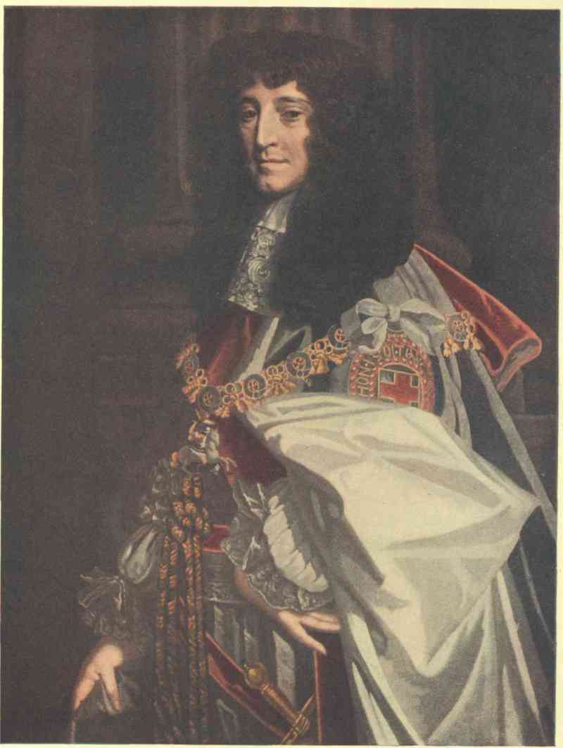
Emery Walker Ltd. photo & imp.
PRINCE RUPERT From the painting by Sir Peter Lely in the National Portrait Gallery
And again:
The whole and entire trade and traffic to and from all havens, bays, creeks, rivers, lakes and seas, into which they shall find entrance or passage by water or land out of the territories, limits and places aforesaid; and to and with all the natives and people inhabiting, or which shall inhabit within the territories, limits and places aforesaid . . . which are not already possessed . . . or whereof the sole liberty or privilege of trade and traffic is not granted to any other of our subjects.
Besides granting the right of trade in furs and fish, the petitioners were given a monopoly of the gold, silver, gems and precious stones found in this vaguely defined region, called in the charter ‘Rupert’s Land.’
The company was thus to have control over all regions whose waters emptied into Hudson Bay. As a result they could claim lordship over the territory drained by such rivers as the Assiniboine, the Saskatchewan and the Red. With a stroke of his pen King Charles made the Adventurers lords of nearly half a continent.
The official name sanctioned by Charles in the charter was: ‘The Governor and Company of Adventurers of England trading into Hudson’s Bay.’ They were made ‘true and absolute proprietors’ and held possession ‘in free and common soccage.’ They were to ‘yield and pay yearly’ to the king and his heirs and successors, whenever and as often as they ‘shall happen to enter into the said countries . . . hereby granted,’ ‘two elks and two black beavers.’
It appears however from the early stock-books of the company that this was not the only reward that the king received. Stock in the company to the amount of £300 was granted to him, and no doubt other sums were paid him and his successors for their generous treatment of the traders. In the reign of William III the king was given 225 guineas as dividend on £300 stock in the company, and this although, as the presenters of the dividend quaintly remarked, the company had been ‘the greatest sufferer of any company from those common enemies of mankind, the French.’
The petitioners were further granted the right
to make, ordain and constitute such and so many reasonable laws, constitutions, orders and ordinances as to them, or the greater part of them . . . shall seem necessary for the good government of the said company, and of all governors of colonies, forts and plantations, factors, masters, mariners and other officials employed.
If any individual or company invaded the territory granted to the Governor and Company of Adventurers of England, their vessels and goods would be forfeited, and one-half of the spoils were to go to the crown, the other to the governor and company.
The company was granted the right ‘to erect and build castles, fortifications, forts, garrisons, colonies or plantations, towns or villages,’ and to bring overseas such men as they should think fit to man their forts. Their servants and soldiers they could punish for misdemeanours according to their own laws. This legal authority was not limited to men in their immediate employment, but they were granted jurisdiction over the inhabitants of all territory covered by their charter.
For obtaining this broad charter Prince Rupert received a promoter’s reward both in money and in stock in the company.
At first the company had a low capitalization, only £10,500. The Adventurers had apparently not much to learn from the methods of modern monopolies, for in 1690 their stock was increased to £31,500 and in 1720 to £103,950, and every pound of these increases was ‘water.’ The dividend of seventy-five per cent paid King William on his stock has already been mentioned. From year to year the dividend varied; on one occasion it was as high as one hundred per cent, on several fifty, and from 1720 to 1759 on the new issue, a dividend running in some cases as high as twenty per cent was declared. For a number of years, however, when the French and English were struggling for control of the bay, the company suffered heavy losses and no dividends were forthcoming.
The strength and importance of the company are admirably shown by the rank of the men who were chosen as governors. Prince Rupert held the position for twelve years. He was followed in office by James, Duke of York, who resigned the governorship only when his brother, King Charles, died and he ascended the throne as James II. John, Lord Churchill, the great Duke of Marlborough, was the third governor, and for six years proved a far-seeing and energetic officer, but lost office when he was imprisoned in the Tower for complicity in a plot to restore the Stuarts to the English throne. The company was truly national in its character, and the greatest men in the nation guarded its interests.
The Honourable Company it has been called and, if a few of the local governors such as the brutal half-breed Moses Norton be excepted, it deserved the name. Its employees were treated with the greatest consideration; promotions were made on merit; injured men were provided for; the old were pensioned, and those depending on employees killed in the service of the company were looked after. The Indians almost from the beginning learned to have confidence in the officials of the Hudson’s Bay Company; they were always sure of fair dealing. When they were in want the company was their friend and advanced them supplies, and the natives rarely failed to pay their debts. If they did, they usually found that the kindly hand that furnished them with food and clothing could become a mailed fist. At first very little liquor was used in trading for furs, but when the company found that French traders and the independent companies from Canada were, by means of brandy, enticing the Indians to their posts, it, too, for the sake of dividends, made use of ‘fire water’ to obtain furs. Had it been left in a full enjoyment of its monopoly the curse of drunkenness might never have played such havoc with the tribes of the Great West and North.
The development of the Hudson’s Bay Company’s trade was gradual. At first two small ships were sent out each year. These were increased to six vessels of larger size, only three of which were in use at a time. On their voyages to the bay these vessels carried not only the crews but bands of soldiers for garrisoning the posts. In eighteen years after the building of Fort Charles at Rupert River forts had been erected at five other places—Albany River, Hayes Island, Moose River, Port Nelson and New Severn. These posts were all in time strongly garrisoned.
As soon as the ice broke up in the rivers leading to the bay the resident traders began their work among the Indian tribes, who came in large numbers from the north, the west, the south, and even from bleak Labrador on the east. Four years after the beginning of the fur trade, Indians from some thirteen distinct tribes were on the books of the Hudson’s Bay Company. When the ships arrived in the summer the posts were usually well stocked with furs ready to be sent to London. The company seems to have secured admirable sailing masters. Their vessels had to navigate stormy seas, rock-bound coasts and straits infested with ice, but the losses from shipwreck were comparatively small.
The employees were bound by an oath of fidelity to the company, but this oath was hardly necessary, as there was from the beginning an esprit de corps among masters and servants alike that made them live up to the title of ‘the Honourable Hudson’s Bay Company.’ For nearly two centuries and a half the company has been in existence and it is still worthy of its name. In the days when as a company it had to struggle for its life it was no doubt guilty of many questionable acts, but as a trading institution the name Hudson’s Bay Company is still synonymous with honesty and integrity.
In 1670, after the granting of the company’s charter, a well-equipped expedition was sent out in two ships to Hudson Bay. Charles Bayly, appointed governor at Fort Charles, accompanied this expedition. The traders, owing to the influence of Radisson and Groseilliers, were better fitted out for commerce with the Indians than on the voyage of 1668. They bore with them an ample supply of beads and such trifles, but they carried, too, a large number of guns, pistols, hatchets and knives, which would be of the greatest service to the Indians in hunting fur-bearing animals.
The ship carrying the governor and Groseilliers sailed direct to Fort Charles, which was to be the headquarters, for the time being, of the company’s business. Radisson crossed the bay and landed at Port Nelson, where he built a rude fort. Here he left a few men to look after the trade in that quarter, and then sailed to Fort Charles, where the two vessels went into winter quarters. In the following spring a fine supply of furs was collected at Fort Charles and Fort Nelson and the cargoes were sent home to gladden the hearts of the Merchant Adventurers. Radisson seems to have flitted between London and the bay. In 1672, no doubt to strengthen his position with the company, he wooed and won Mary Kirke, the daughter of Sir John Kirke, one of the most influential stockholders.
Meanwhile the authorities in New France had become alarmed. They learned from friendly Indians that several large English ships had been seen on the Sea of the North and that trading-posts were being established there. New France depended for its very existence on the fur trade. The authorities saw grave danger from an English settlement on Hudson Bay. Should it succeed they would find their country wedged in between the English colonies on the south and the region ruled over by the fur traders on the north.
The rulers of New France looked upon the Hudson’s Bay Company’s traders as intruders on their territory. On account of the discoveries of Jacques Cartier and Roberval, the French laid claim to the entire region extending to the Pacific Ocean on the west and to the Arctic Circle on the north. Immediately after the Hudson’s Bay Company began operations, New France laid more explicit claim to Hudson Bay and the country surrounding it. It was maintained that a number of French explorers had reached the bay before the company entered it, and had taken possession of it in the name of the king of France. These men were Jean Bourdon, who was said to have explored, in 1656, the Labrador coast and entered the bay; Father Dablon and the Sieur de la Vallière; the Sieur Couture, and the Sieur Duquet. There appears to be no good evidence that any of these men ever saw the waters of Hudson Bay. Even if they had reached it before the building of Fort Charles, Hudson, Button, James and Foxe had all been before them and had taken possession of the country for England. It is a significant fact that in the claims regarding the right to the territory surrounding Hudson Bay no mention is made of the overland voyage of Radisson and Groseilliers. When they made their journey they were citizens of New France, and if the French authorities had been aware of such a journey they would have used it to strengthen their claim.
Jean Baptiste Talon, the energetic intendant of New France, determined to take steps to thwart the Hudson’s Bay Company in the fur trade. To this end he sent Father Charles Albanel and the Sieur de St Simon with six Indians to the Bay. This expedition was to ‘penetrate as far as the Mer du Nord; to draw up a memoir of all they would discover, drive a trade in furs with the Indians, and especially reconnoitre whether there be any means of wintering ships in that quarter.’ The voyageurs succeeded in reaching the bay, and not only spied out the land but so influenced the Indians that there was, soon after their arrival, a distinct falling off in the Hudson’s Bay Company’s business. The company stuck to the coasts and waited for the Indians to bring their furs to the factories, but the French intercepted the natives as they came down the streams from the west and north and induced many of them to take their packs to New France.
An effort was made in 1673 by agents of Frontenac to entice Radisson and Groseilliers from the service of the Hudson’s Bay Company and back to their own people. According to some authorities Groseilliers and Radisson deserted at Fort Charles and returned to New France. But the records of the company show that in 1673 they journeyed to London on the Prince Rupert to answer charges made against them by the governor and Captain Gillam, and to urge on their own behalf better treatment from their employers. They were by this time thoroughly dissatisfied with their position. It was entirely due to them that the trade in furs had been undertaken by the Merchant Adventurers. Their experience was making the venture a success, and yet they were mere hirelings, without stock in the company, and with no chance of making the fortunes they had hoped for when they entered into negotiations with Sir George Carteret. As they could not secure the terms they demanded they refused to return to the bay and, breaking their oath of fidelity, went to France to seek service under Colbert, the astute minister of Louis XIV.
Colbert was suspicious of the two traders, especially of Radisson, who, through his marriage with Mary Kirke, had become peculiarly identified with the English company. He advised Radisson to return to Canada to seek service under Frontenac. Radisson did so, but was unsuccessful, and he returned to France and entered the French navy. In 1676 while on shore leave he met the Sieur de la Chesnaye, one of his former Canadian fur-trading friends, and was persuaded by La Chesnaye to return with Groseilliers to New France.
It was not until 1682 that the two ambitious traders got an opportunity of visiting Hudson Bay in the interest of New France. In that year, owing to the influence of La Chesnaye, two vessels, the St Pierre and the Ste Anne, were equipped for the fur trade. In these leaky, unseaworthy craft, after a perilous voyage, the Hayes River was reached.
Radisson at once went to the interior and entered into trade with the Indians. On his return down the Hayes River he learned that a large vessel was in the Nelson. He visited it and found that it was a free-trader, the Bachelor’s Delight, under the command of Captain Ben Gillam, son of Zachariah Gillam, the trusted captain of the Hudson’s Bay Company. Although Gillam the elder was in the pay of the company he was nevertheless anxious to better his financial position by assisting his son to carry on illegal trade.
A few days after meeting young Gillam, Radisson learned that another ship was entering the Nelson. It was Zachariah Gillam’s vessel, with Governor Bridgar on board. Radisson with his small force and weak vessels was in a dangerous position, but he was equal to the situation. He managed to keep the two English ships from becoming aware of each other’s presence. Bridgar’s vessel was wrecked and Captain Gillam and a number of the crew were drowned. With the remainder of the crew Bridgar took up his residence in a rudely constructed fort. Ben Gillam had likewise constructed a species of fort on the Nelson. Through most wily practices Radisson succeeded in making Bridgar, Ben Gillam and their men prisoners. The French then laid in an abundant store of furs, sent the crews captured to Fort Moose and Fort Charles and sailed in the Bachelor’s Delight, heavily laden with beaver-skins, with Bridgar and Gillam as prisoners, to Quebec. Radisson left at his fort on the Hayes River a body of men under the command of his nephew, Jean Baptiste Groseilliers. To his fort he gave the name Bourbon.
Frontenac had tacitly consented to Radisson’s expedition, but Frontenac was no longer at Quebec. La Barre was governor in his stead, and La Barre was most avaricious. On the arrival of the Bachelor’s Delight the cargo of furs was practically confiscated, and Radisson and Groseilliers were ordered to report to Colbert in Paris. Meanwhile Gillam’s vessel had been returned to him and Bridgar released. The traders had once more been plundered by the authorities in New France. They hoped for redress in Paris, but it was a vain hope.
News of Radisson’s exploit had reached England, and the Hudson’s Bay Company urged the French government to punish men who had plundered British territory in time of peace. The traders saw little hope of advancement in France. They had friends at court in England. A Mr Young was Radisson’s staunch supporter and urged him to return to London. Radisson adroitly played the one nation against the other. Finally, even while pretending to be about to enter the service of the French government he made excuses that, on account of family affairs, he had to pay a visit to London. He returned to England, where he was enthusiastically welcomed by the very men whose property he had so recently plundered. He once more took the oath of fidelity to the company. He was lionized, made a stockholder in the company to the extent of £200, and presented with a silver tankard.
In the summer of 1684 the Happy Return and the sloop Adventure sailed for Hudson Bay with Radisson on board as superintendent of trade. Jean Baptiste Groseilliers was greatly surprised to find his uncle in command of an English expedition. He was loyal to New France and, but for the weakness of the force under his command, would have given battle to the English. He was compelled meekly to surrender his fort with its supplies and two hundred and thirty-nine packs of beaver-skins. The fleur-de-lis was hauled down and the English ensign with the design of the Hudson’s Bay Company raised in its stead over Fort Bourbon. Nothing could induce young Groseilliers to take service in the company, but, when the ships were loaded and ready for the return voyage, he and four of his men were induced to board the Happy Return just before the anchor was lifted, and they were carried away to England. Excellent offers were made to the young Frenchman and his comrades in London to throw in their lot with the company, but it was not until the spring of 1685 that they consented.
Radisson’s expedition had been of the utmost importance to the Hudson’s Bay Company. It enabled the directors in 1684 to pay a dividend of fifty per cent. Radisson was in high repute and was granted a salary of £100 a year when out of England, and £300 was to be given to his wife in case of his death. This did not satisfy Radisson, and to keep him faithful the company added £100 stock to be given to his wife.
Radisson remained in the service of the company for many years. Towards the close of his life he was in greatly straitened circumstances, and died in poverty in 1710 in the seventy-fourth year of his age. Groseilliers, his brother-in-law, had long since returned to Canada, where he died among his friends in 1691.
Thus passed from the stage two of the most remarkable men of their age—fearless, energetic explorers—unreliable, it is true, but they were sorely tempted. They were the real fathers of the Hudson’s Bay Company. It was due to their enthusiasm and enterprise that Hudson Bay was opened for trade to the English. But for them New France would assuredly have gained and held undisputed possession in the north country during the seventeenth and eighteenth centuries.
The French trading-post established on the Hayes River by Radisson had been looted in the interest of the Hudson’s Bay Company by this same Radisson. New France was furious and a price was set on the trader’s head. A new trading company had been formed called the Company of the North, and its members determined to use every endeavour to destroy the trade of the English company on the bay.
In 1685 two ships had been sent from Quebec loaded with merchandise which was to be exchanged for furs. Through the summer these vessels cruised about the bay, but so strong had the English company made itself with the Indians that not a savage came to trade with the French. Late in July the ships were returning without the cargoes of furs their owners had anticipated. The captains and crews were feeling bitter against their enemies when the Hudson’s Bay Company’s boat the Perpetuana was met in Hudson Strait sailing for Fort Nelson, loaded deep with merchandise and provisions. Here was a chance for revenge! France and England were at peace. But what of that? Had not the English stolen the furs from Fort Bourbon and carried off the French garrison? The Perpetuana was not strongly armed, and the French had little difficulty in boarding her; but the English ship did not yield till a number of her crew lay dead on her deck. The Perpetuana was taken as a prize to Quebec, where her captain, Edward Hume, and his men were thrown into prison. Hume died after eleven months’ imprisonment. His men were cruelly treated, and in the end sent to Martinique to be sold as slaves. Hume’s mate, Richard Smithsend, escaped and brought the news of this outrage to England, and the nation was worked up to a great pitch of indignation by this brutal act of piracy.
Meanwhile one Jean Péré, with two companions, had been sent to James Bay to spy out the strength of the forts there. He was hospitably received at Fort Albany by the unsuspecting governor, Henry Sargeant. While Péré was at the fort news was brought to Sargeant of the fate of the Perpetuana, and the irate governor put him in irons, locked him up in the dungeon of the fort, and afterwards sent him to England to stand his trial as a spy. His two companions were marooned on Charlton Island, but in the autumn they managed to escape to the mainland and made their way across country to the Great Lakes and thence to Quebec. They told harrowing tales of the cruel imprisonment of Péré.
Chevalier Pierre de Troyes, an officer of the famous Carignan-Salières regiment, made use of this incident as a means of raising a force to march overland to attack the Hudson’s Bay Company’s posts on James Bay. Denonville, who was now governor of New France, listened with interest to his plans and gave him aid in fitting out a force of one hundred men, two-thirds of whom were Indians, for his perilous trip. De Troyes took with him as his lieutenants three young members of the noblesse. They were the three sons of Charles le Moyne. The Le Moyne name has ever been illustrious in the annals of Canada, but none of that name has been more daring and resourceful than the Sieur d’Iberville, the Sieur de Sainte Hélène and the Sieur de Maricourt, who had been named by their parents after places in Old France and New France.
In the early spring of 1686 de Troyes led his daring band out of Montreal. When the ice broke up in the Ottawa they made canoes and ascended that river. They then crossed overland by way of Lake Timiskaming and Lake Abitibi, descended the Black and Abitibi Rivers to the Moose, and after three months of arduous and dangerous voyaging, uncomplainingly endured by those experienced wood-runners, they were in the vicinity of Fort Moose at the western end of James Bay.
No tidings of the approach of the French had been brought to Governor Nixon, and the fort was totally unprepared for resistance. It was feebly manned by inexperienced apprentices. D’Iberville led a night attack against it. The sleeping sentinel at the gate was slain with one swift stroke; the gates were burst open, and in a moment the panic-stricken garrison were prisoners. Furs and merchandise and fourteen cannon, six and eight-pounders, and three thousand pounds of powder were found in the fort, and sixteen men were captured.
After the fall of Fort Moose the elated raiders turned their attention to Fort Charles on the Rupert River. Governor Bridgar, who had been suspended from office for his cowardly surrender to Radisson four years before, had been reinstated, and was in a sloop at the mouth of the Rupert River ready to take charge of the fort. Towards the end of June de Troyes set out for Fort Charles. A shallop had been constructed, and several small cannon were taken from Fort Moose to batter down the walls of Fort Charles if any resistance were offered.
D’Iberville was the first to reach Rupert River. He learned that a sloop manned by fourteen men, with the governor on board, was at the mouth of the river. He led a party of Indians to the vessel in canoes and stole stealthily upon it; unobserved his men reached its sides, scrambled over the gunwale, and instantly slew the only man on guard on deck. When the crew rushed from their cabins to see what was the cause of the stamping above their heads, the two who first appeared were slain and the remainder were taken prisoners. The fort was next attacked. It seems to have made some show of resistance, as bombs or hand-grenades were thrown into it, killing or injuring five of the garrison. It was useless to resist, and the officer in charge surrendered. While this attack was being made de Sainte Hélène captured another of the company’s vessels which happened to be in the river. Fort Charles, the first fort established on the bay, was dismantled and the palisades thrown down.
Carrying with them thirty prisoners and much loot, the French under de Troyes next turned their attention to Fort Albany. This post was the strongest one on the bay. It was in command of an energetic officer already mentioned, Governor Henry Sargeant. It had four bastions, and forty-three guns frowned from the walls. Governor Sargeant had been warned by an Indian of the fate of Fort Charles and Fort Moose and of the approach of the raiders, and promptly made preparations to withstand a siege. The fort, however, was in reality in a very weak state. There were few soldiers in the garrison, and Sargeant and other officers had with them their wives and families and they dreaded the attack. Moreover Fort Albany was short of ammunition. It could not reply to the guns of the enemy for more than a couple of days.
D’Iberville and his voyageurs reached the vicinity of the fort in canoes in advance of de Troyes, who came with the prisoners in the big sloop they had captured. Cannon had been brought along to breach the walls. A landing was immediately made and an entrenched position taken up within musket-shot of the fort.
For two days the walls were bombarded and the defenders made a feeble response. The garrison was in a mutinous condition. The chief gunner, Elias Turner, urged his comrades to surrender, but brave old Governor Sargeant drew a pistol and threatened the gunner with death if he did not return to his guns. Soon a breach was made in the walls. Governor Bridgar was now sent forward under a flag of truce to advise capitulation. He pointed out that the French had with them a large force of Indians. If resistance to the bitter end were made, the garrison would in all probability be massacred by the infuriated savages. The ammunition was exhausted, the families of the officers were in peril of their lives, and the men of the garrison were praying the governor to surrender. Sargeant had done his best under the circumstances, and there was nothing left for him to do but to yield to the demands of the enemy.
During the negotiations for surrender Sargeant and d’Iberville behaved in the most friendly manner towards each other, and drank the healths of King Louis and King James in several bottles of Spanish wine. The officers and their families were sent to Charlton Island to await the company’s vessel that would take them to England. The servants captured were not so kindly treated. The Canadians had secured enormous plunder; fifty thousand beaver-skins were taken in Fort Albany alone. English prisoners were retained to help carry this prize back to New France. Some fifty were left at the bay. These had to depend largely on their own resources. In the winter of 1686-87 they endeavoured to tramp their way to Fort Nelson. All but twenty succumbed to the hardships of the winter. De Troyes and the Le Moynes had taken a terrible revenge for the action of the company under Radisson’s leadership.
Meanwhile, in the old world, France and England were at peace. An effort was made to end this trading strife on Hudson Bay, and a treaty of neutrality was signed by King Louis and King James in 1686. It was hoped that this would put an end to the struggle in America, but the rival trading companies in the northern wilderness were in no mood to observe the Act of Pacification.
The indefatigable d’Iberville was once more on the bay in 1687. At Rupert River he found a Hudson’s Bay Company sloop, which he promptly seized. He discovered that Captain Bond was wintering in the ship Churchill at Charlton Island. He sent four spies to report on the strength and position of the Churchill. These men were taken prisoners by the English. In the spring one of them was released to aid in getting the Churchill afloat and ready for sea. This Frenchman bided his time, and, when six of the crew were aloft unbending the sails, he seized an axe and brained two men who were left on the deck. Before the sailors in the rigging could descend he had released his companions and at pistol-point they took possession of the ship. The Frenchmen, who a moment before had been prisoners, exultingly steered the Churchill to Fort Charles, where they handed her over to d’Iberville.
In 1688 the company had established a fort at New Severn, with the hope of attracting Indians there with their furs and keeping them from visiting the forts in possession of the French on James Bay, but in the autumn of the following year d’Iberville captured this fort and took the company’s governor prisoner.
D’Iberville then returned to Albany, which the French had renamed Fort Ste Anne, only to find that the Hudson’s Bay Company had sent out two ships, with eighty-three men, for the purpose of recapturing it. The English had a new fort partly constructed and were landing cannon for siege purposes. D’Iberville ambushed twenty-three of the enemy as they were going to one of the vessels for supplies and took them all prisoners. He finally compelled the English to surrender, but not before they had set one of their vessels on fire; the other was taken intact and was found to contain a rich cargo of furs. On this vessel, with a large body of prisoners, he sailed for Quebec. On approaching Hudson Strait d’Iberville came into contact with one of the company’s armed vessels. He was on a British ship, and by flying the British flag he managed to deceive the enemy and to make his escape without mishap. Fort Nelson was now the only British fortified post on the bay, and in these years of strife the company had sustained a loss of over £100,000.
The misfortune sustained had been largely due to d’Iberville’s work. That daring Frenchman’s name had become a source of as great dread to the English on the bay as had Drake’s to the Spaniards in the reign of Elizabeth. For a few years they were to be freed from his operations. Frontenac needed him for his campaign against New England, and d’Iberville joined one of the three famous war parties against the British colonies to the south. It was due to his dash and energy that Schenectady fell a prey to the wood-runners and Indians of New France.
Although the French were in possession of the trading-posts established by the British on James Bay they were not prospering. ‘The Company of the North’ had to send supplies overland, and to carry its packs of furs back by the same route. It did not seem to have the capital or enterprise of the Hudson’s Bay Company, and could not obtain vessels that would enable it to conduct its trade by the sea route. It was found that unless this route were used the fur trade could not be made profitable. Besides, the Hudson’s Bay Company still had Fort Nelson, and was able to offer better terms for furs to the Indians. The French coveted this trading-post. It was comparatively near to the Indian tribes of the west and north, and to it the most valuable furs were brought. One pelt from the Far North was worth two taken in the warmer South. The Company of the North tried to get Nelson by negotiations. It offered the forts captured on James Bay in exchange for it, but the English very naturally refused the offer. The French then determined to try force. England and France were now at war, and it would no longer be a matter of piracy to seize British forts and ships.
A French frigate was sent to the bay in 1691. It appeared at Port Nelson at a time when the majority of the company’s servants were absent trading with the Indians. Governor Phipps, who was in command, knew that surrender was inevitable. There were in the fort stores worth £8000. Phipps determined that these should not fall into the enemy’s hand, and so he promptly set fire to the fort, and it and the stores vanished in smoke. When the French landed the English had fled, and the prize they expected to win was a mass of flames. Winter was approaching, the frigate was not prepared to winter in the bay, and the disappointed crew set sail for the Atlantic.
In 1692 the Hudson’s Bay Company sent out a strong expedition, and the post, variously called Fort Bourbon, Fort Nelson and York Factory, was built on a larger scale than formerly and was better fitted to withstand a siege. Governor Bayly took charge of the new fort, and the three ships spent the winter there. In the spring an expedition was sent to Fort Albany for the purpose of capturing it. Captain Mike Grimmington, an experienced Hudson Bay sailor, was in charge. Forty men were landed, and advanced against Fort Albany. The guns on the walls thundered a single volley, but the British advance was not checked. The English marines burst the gates open, only to find the place deserted. In the cellar they discovered a wretched creature sick with scurvy, in irons and chained to the wall. This was a murderer who had slain the surgeon of the fort and a priest named Father Dalmas. Three men were observed fleeing for the forest. These were captured, and it was learned that they were the only garrison of the fort. The English flag was hoisted over Albany, and the prisoners were sent to England. Governor Knight was placed in command of the fort.
The English were not long to remain in possession of Fort Nelson. D’Iberville was once more turning his attention to Hudson Bay. In 1693 he visited France, and laid before the French government a plan by which he hoped to drive the English entirely from the bay. He returned to Quebec after receiving a promise that two strong ships would be granted him in the following year for the reduction of the Hudson Bay posts.
The warships Joli and Salamander arrived in Quebec in August 1694. On the 10th of the month d’Iberville set sail for the bay, and on September 24 cast anchor at the mouth of the Hayes River. Troops were landed at once, and cannon, mortars and ammunition were sent ashore. Batteries were erected within five hundred yards of the palisades surrounding Fort Nelson, and for three weeks the place suffered a severe bombardment. D’Iberville’s men made frequent attempts to cut their way through the palisades, but were repulsed by the besieged, ably led by Governor Bayly and his experienced lieutenants, Kellsey and Walsh. In one of these efforts to storm the walls, Chateauguay, d’Iberville’s brother, was slain. The garrison meanwhile had sustained heavy loss, and the governor was compelled to surrender. D’Iberville spent the winter at Port Nelson, and in July 1695 sailed away, leaving the Sieur de la Forest in charge there. The fort once more took the French name Bourbon, and the name of the river on which it was situated was changed by d’Iberville from Hayes to Ste Thérèse. Once more the company’s fortunes were at a very low ebb. Fort Albany was now the only post left it on the bay.
The Merchant Adventurers did not allow the French to remain long in possession of Fort Nelson. In 1696 the Bonaventure and Seaforth sailed for the bay under the command of Captain William Allen. Port Nelson was reached on August 29, and on the following day the French were attacked in force. La Forest was in no position to withstand a siege, and on the 31st of the month he capitulated. Contrary to the articles of capitulation, the prisoners were carried to England, where they suffered imprisonment in Portsmouth for four months. Along with the prisoners a valuable cargo of twenty thousand beaver-skins found in the possession of the French was sent to the warehouses of the company.
The year 1697 was to be the most stirring one in the history of the struggle for the possession of Hudson Bay. When the prisoners captured at Fort Nelson in 1696 were released they immediately took passage for France. While in prison they had been harshly treated, and on their arrival in Paris they had a tale to tell of injustice done them and hardships endured which roused the French government to immediate action.
D’Iberville was the man best fitted to take vengeance on the English. This experienced soldier and sailor (d’Iberville held rank as lieutenant in the French royal navy) was in Newfoundland laying waste the country. He had already captured and burned St John’s, and taken and destroyed every settlement save those at Bonavista and on the island of Carbonière, and he was spending the winter of 1696-97 at Placentia, making preparations to complete the destruction of the remaining settlements. But the French government had other work for him to do. In the spring of 1697 d’Iberville’s brother Serigny arrived at Placentia with five warships—the Pelican, the Palmier, the Wesp, the Profound and the Violent. With this fleet, under the leadership of d’Iberville, it was the intention of the French government to drive the English from Hudson Bay and to take full vengeance on them for their treatment of La Forest and his men.
The Hudson’s Bay Company had made simultaneous preparations to send a strong naval force to their posts on the bay. In the summer of this year the Hampshire, Captain Fletcher, the Dering, Captain Grimmington, the Hudson’s Bay, Captain Edgecombe, and a small sloop set sail from England for Port Nelson. The Hampshire had 52 guns, the Dering 36 and the Hudson’s Bay 32. It was a race between the French and English fleets for the bay, and both were retarded within sight of each other by the ice of Hudson Strait. So close were they to each other at one time that the English vessels exchanged shots with the Profound. The Pelican first succeeded in breaking her way through the ice, and arrived without mishap at Port Nelson, where the garrison of the fort was anxiously awaiting the arrival of the British ships. The remainder of the French fleet were not so fortunate, and for two days d’Iberville awaited their arrival. Finally, fearing that they had either been captured by the enemy or crushed by the ice, he contemplated attacking the fort with the marines and sailors of the Pelican. Autumn storms were already sweeping the bay, and delay was dangerous. While he meditated making a landing he saw in the distance three vessels under full sail sweeping towards his anchorage. Thinking they were the missing vessels of his fleet, he raised anchor and made sail to meet them. He soon discovered, however, that they were the British armed vessels he had met in the strait. He was now in a critical position; a storm-lashed shore lay before him, and the Hampshire and Dering and Hudson’s Bay cut off his retreat.
D’Iberville was a man ever ready to grapple with fearful odds. Without hesitation he made preparations to do battle in the Pelican with the three British ships. Guns were run out, the gunners stripped to the waist, the infantry under his brother, Bienville, took up their station, and a company of Canadian and Indian sharpshooters in charge of La Potherie, who afterwards wrote an account of this thrilling naval battle, made ready to pick off the enemy when they got within musket range.
The English vessels advanced, confident of victory. The Hampshire took the lead; she was closely followed by the Dering, while the Hudson’s Bay brought up the rear. The Hampshire and the Pelican were vessels very similar in size, armament and crews. The Pelican had but forty-four guns to the Hampshire’s fifty-two, but seems to have had the advantage in weight of metal.
D’Iberville steered his ship straight for the Hampshire. At nine o’clock in the morning the thunder of the guns began to roll over the heaving waters of the bay. It was the evident intention of d’Iberville to board the Hampshire, but Captain Fletcher skilfully manœuvred his ship and prevented the crew of the Pelican from grappling. Under her headway the French ship swept past the Hampshire and poured a damaging broadside into the Dering. She then turned her guns on the Hudson’s Bay, and a storm of iron swept the hull and decks of that little vessel. The Pelican had not accomplished this without suffering severely. She had sailed so close to the Dering that the English sailors could hear d’Iberville shouting his orders. A volley of musketry and grapeshot was poured into her. She staggered under the blow, and, with forty men killed and wounded, her masts smitten, her hull rent and her sails torn, she veered away to renew her attack on the Hampshire. The English vessels were directing a concentrated fire against the rigging and decks of the Pelican, hoping to reduce her to a useless, unmanageable hulk. D’Iberville adopted other tactics. The heavily built Hampshire was his main object of attack and he strained every effort to sink her. The gunners of the Pelican depressed their guns, and at pistol range poured broadsides into the Hampshire, striking her repeatedly between wind and water. Great gaps were made in the English ship’s sides. Suddenly she was seen to careen, and almost before the Pelican could get out of the danger zone she was swallowed up in the sea with all her sails spread. To the depths of the bay she carried her entire crew. In the battle, which had now lasted for over three hours, the Pelican had lost ninety men killed or wounded. Scarcely had the Hampshire disappeared beneath the waves than d’Iberville turned his attention to the Dering, but the English ship crowded on all sail and escaped, and the Pelican was too much crippled to follow after her. The Hudson’s Bay was not so fortunate, and was forced to surrender.
During the battle the storm had increased in fury. By night a fierce gale, accompanied by a blinding snowstorm, was raging. The Pelican and the Hudson’s Bay both cast anchor on a lee shore, but the force of the storm parted their cables, and they were driven aground several leagues from Port Nelson, helpless wrecks. The crews managed to reach the shore, but so greatly did the crew of the Pelican suffer that twenty of them perished from exposure immediately after landing.
Rude huts were built, fires were lit, and, while the gale raged furiously in seeming mockery of their victory, the shivering followers of d’Iberville crouched about the fires. They were practically without provisions, and had no means of erecting proper shelters. All must inevitably perish unless Fort Nelson could be taken by assault. Arms and ammunition had with the greatest difficulty been brought ashore, and the undaunted d’Iberville determined to lead his exhausted band against the strong walls of the fort. However, to his delight, three of the missing French ships hove in sight and the entire situation was changed.
A strong force was sent ashore. Cannon and mortars were landed, and Fort Nelson was once more subjected to a siege. Governor Bayly bravely replied to the attack; but his walls were protected by only small guns, and he was unable adequately to resist the powerful weapons brought against him by the French. Three times he was requested to surrender and three times he refused. At length when the French bombs were dropping in every part of the fort, convinced that it would be a useless throwing away of life to hold out longer, he agreed to the terms of the besiegers. The fort was handed over to d’Iberville after its defenders had marched out with their arms and baggage to the beating of drums and with their colours flying.
For fifteen years after d’Iberville’s naval victory and capture of Nelson the Hudson’s Bay Company experienced dark days. Even before news of the catastrophe of 1697 reached England it had to fight for its existence. There were energetic enemies in the homeland. The directors made an application to parliament for a renewal of the trade privileges granted them by royal charter in 1670 and again in 1690. There was a counter-petition from the Felt Makers’ Company and the Skinners’ Company urging that the Hudson’s Bay Company’s charter be not renewed. The petitioners maintained that the company was a private monopoly and not a national enterprise. It was accused of having neglected to perform the duties imposed upon it when the original charter was granted. In that charter it was stated that efforts were to be made to find a north-west passage to the South Sea. No efforts had been put forth in this direction; all the company’s energies had been directed towards making profits from the fur trade. The prices charged for furs were exorbitant and there was apparently no redress through its control of the fur market. However, the company proved too strong for its enemies. But for it Hudson Bay would have been lost to Great Britain. Under the greatest difficulties it had maintained a foothold on the bay. This was recognized and the old privileges were renewed, and the petitions of the company’s enemies were of no avail.
As early as 1694 the Hudson’s Bay Company made a demand on the British government for damages sustained from the French. This bill amounted to the enormous sum of £211,255, 16s. 3d. In it were enumerated the forts and ships captured and destroyed, the merchandise and furs seized, and the injury done the trade in a general way. Despite its losses, so enormous were its profits, it still had a balance on the right side. But the achievement of d’Iberville in 1697 left it almost bankrupt. The fleet he had destroyed had been equipped and manned with borrowed money, and the company was even forced to borrow to pay the sailors their wages.
The greatest blow suffered was through the Treaty of Ryswick. From 1690 to 1697 ‘The Grand Alliance’—Germany, Spain, Holland and England—were at war with France. The war terminated in 1697, and on May 7 of that year a treaty was signed near the village of Ryswick in Belgium that gave a brief peace to Europe and curtailed the power of France save in Hudson Bay. By the Treaty of Ryswick the Hudson’s Bay Company found itself shorn of its great privileges on the bay. Of its seven forts only Albany was left, and Fort Nelson or York Factory, the most important centre of trade, remained in the hands of the French. The company still continued to trade with the Indians about James Bay, but it was so heavily in debt and so handicapped that for many years no dividend was forthcoming. So humble did the directors become that they offered to divide the bay with the French, keeping the northern portion where the richest furs were found, and granting the French a monopoly of the trade between Rupert River and Fort Albany. Their situation was desperate, and later, when war was renewed, they begged that a fleet should be fitted out, and an armed force sent to the bay of sufficient strength to drive the French from its waters.
The French in the meantime were not finding life at their newly won posts on Hudson Bay a bed of roses. The Company of the North that superseded the Hudson’s Bay Company at Nelson steadily lost money on its new venture. It had no vessels with which to carry on the trade, and Nelson was too far to the north to make the overland route a profitable one. New France could give but little assistance, and Old France seemed to take but little interest in the work of the fur traders.
When d’Iberville sailed away from Nelson he left Martigny in charge as commandant of the fort. Between 1697 and 1708 three different commanders resided at Nelson. In the latter year Jérémie took command. He found himself isolated in the wilderness with a scanty supply of stores with which to trade, and with but little ammunition to resist attack. No ships came from New France or Old France. Several were sent, but the English were masters of the northern seas and had captured these vessels. Through lack of supplies it was impossible to carry on trade with the Indians who came to the forts with abundant packs of furs, and they were forced to take them away again. The Redskins longed for the good old days of the Hudson’s Bay Company, when they ever found the goods they coveted and always had a kindly welcome. They began to feel resentment against the French traders, and Jérémie and his men were in danger of their lives. In 1708 a small body of men were sent from the fort to visit an Indian tribe camped in the vicinity. The Indians, although they had abundant furs, were starving. In their rage they fell upon the Frenchmen and slew them all. After this incident Jérémie feared that the savages would attack his fort and slay him and his men. It was not until 1713 that a vessel arrived from France bringing much-needed supplies.
Shortly after this the French had to withdraw from the bay altogether. The War of the Spanish Succession was then convulsing Europe. It had been waged from 1700 to 1713, when the victories of the Duke of Marlborough in Flanders and the Archduke Charles in Spain forced Louis XIV to sue for terms. The Treaty of Utrecht resulted. By this treaty the entire Hudson Bay region was ceded to the British, and the French were ordered to evacuate the posts they held there and to surrender all war material within six months. It was also arranged that commissioners should be appointed to define the boundaries between New France and the British possessions to the north. The Hudson’s Bay Company was likewise to receive compensation for damages done to their property and trade during times of peace.
In June 1714 Governor Knight, one of the most experienced officers of the Hudson’s Bay Company, and his deputy Henry Kellsey, who had a high repute as a trader and explorer, sailed from Gravesend for Port Nelson. They had instructions to take possession of York Fort (Nelson) and of all other places in the Bay and Strait of Hudson. On their arrival Jérémie handed over the keys of the fort to Knight, and he was no doubt glad to escape from the region where he had suffered much, and where latterly he was in constant dread of his life.
The English and French governments were slow to act with regard to the boundary question. It was not until 1719 that any important step was taken to deal with the matter. In that year Daniel Pulteney and Martin Bladen were chosen as English commissioners to act with the French commissioners, Maréchal Comte d’Estrées and Abbé Dubois, minister and secretary of state. The commissioners met in Paris, and Sir Bibye Lake, the governor of the Hudson’s Bay Company, attended their conferences in the interests of the company. There was much discussion and examining of musty documents, but finally the commissioners adjourned indefinitely without bringing the boundary question any nearer a settlement. French traders took advantage of the unsettled state of the boundary to extend their trade into the interior and invaded many of the rivers whose waters flowed into Hudson Bay. The company, however, flourished. It had undisputed control of the bay, and by 1720 the directors were able to treble their stock and still pay enormous dividends.
Louis XIV gave little or no attention to the demand for compensation for damages. The enormous bill at first presented by the company was ignored. When the company had recovered its old privileges it once more pressed for the payment for damages received in time of peace. A bill presented in 1714 was much more modest than the one it had made out in 1694. It amounted to only £100,543, 13s. 9d. As the company pointed out, this bill did not include either the loss of forts or damages suffered by the trade. Payment was promised, but the matter was finally written off, and the company with its enormous profits could well afford to stand the losses. Its trade was greater than it had ever been. The Indians welcomed the return of the English company, and came in vast numbers to the forts and the factories on the bay, and the warehouses in London were soon packed to overflowing with furs.
The company branched out in many directions. As early as 1688 an expedition had been sent to the Churchill River to establish a trading-post there. The farther north the richer the fur, and the Churchill was most advantageously situated for trade. In 1718 a substantial wooden fort was built on the river a short distance from its mouth. So important did this centre prove that it was later decided to construct a fort in this quarter on a magnificent scale, and between the years 1733 and 1771 Prince of Wales Fort, one of the strongest fortifications on the American continent, was erected. It was of massive masonry and was designed by the ablest English engineers of that time. The fort was over one hundred yards long on both the north and south sides. The walls were from thirty-seven to forty-two feet in thickness, and on these walls forty guns were mounted. The fort still stands on Eskimo Point, west of the mouth of the river, with its guns rusting and neglected on the mouldering walls, a grim monument to the hopes and fears of the great company. The fort has long been unoccupied, the company’s factory being situated farther up the river on the site of the original fort.
Operations were carried on extensively on the East Main, and a fort, in which was a garrison of eight men, was erected on Slude River. In 1720 a contingent was sent one hundred and fifty miles up the Albany River and established Henley House to serve as a check on some of the tribes who carried their furs from this point to the French traders operating in the west and south. The establishment of Henley House was important. It marks the first attempt of the company to carry its operations inland, and was the initial undertaking in the system of factories that finally dotted the northern part of the continent with trading-posts. It was the forerunner of Fort McPherson at the mouth of the Mackenzie River, Fort Yukon in the north-west corner of the continent, Fort Simpson on the Pacific coast, Fort Walla-Walla on the Columbia River, and the numerous posts on the great rivers and lakes of the Middle West.
The dark days were past; calm had succeeded storm. No longer did the vessels of the company sail into Hudson Strait fearing capture and destruction; no longer did the garrisons in the forts stand in dread of French battleships or overland raiders. All their energies were devoted to extending trade among tribes only too eager to exchange furs for merchandise.
The attack of the Felt Makers and Skinners, especially with regard to their contention that the Hudson’s Bay Company had made no effort to discover a north-west passage or to explore the vast regions granted to it by royal charter, caused the company to advance evidence that it had not been indifferent in this regard. The journal of Henry Kellsey was produced as proof that effort had been made to explore the interior of North America. By many this journal was considered in the light of romance, a document manufactured to suit the purposes of the company; but a careful examination of it should convince any one of its authenticity.
Henry Kellsey, as a mere lad, showed a special liking for the roving life of the Indians. In 1688 Governor Geyer had gravely considered sending him on an expedition in the interests of trade to the Churchill River, giving as a reason the youth’s fondness for Indian society. In 1690 Geyer records that he ‘sent up Henry Kelsey into the country of the Assinae Poets [Assiniboines], with the Captain of that Nation, to call, encourage, and invite the remoter Indians to a trade’ with the company. On this expedition Kellsey was instructed ‘to search diligently for mines, minerals or drugs of what kind soever, and to bring samples down with him.’
According to another story, Kellsey had been chastised by the governor for some breach of discipline and, deserting, spent a year among his Indian friends. Knowing that the company was anxious to get into touch with the western tribes, he sent a messenger to the fort agreeing to return, and promising to set out on an extensive exploring expedition. The governor welcomed the lad back, and equipped him for a journey into the unknown wilderness.
According to his journal, Kellsey left York Factory early in July 1691. He paddled and tramped far into the North-West, meeting new peoples and experiencing thrilling adventures. His journal is so vague in its topography that it is vain to endeavour to trace his wanderings. Some historians claim that he reached Lake Winnipeg, the western plains, and even approached the Rockies. The main evidence for this is his reference to the herds of buffalo he saw and his adventures with grizzly bears. It is most probable, however, that he travelled in the direction of Reindeer Lake and visited the barren lands in that region. He claimed possession of the country he explored on behalf of the company. He had much influence with the Indians, and caused many new tribes to visit the company’s factory at Nelson. He was most unfavourably impressed with the country through which he passed, and as a result of his explorations the company reported to parliament in both 1697 and 1749 that ‘the country where they gathered furs was not fit for habitation by men.’
Kellsey was highly esteemed by the Hudson’s Bay Company, which would hardly have been the case had he been a fit subject for chastisement. In 1694, so bravely did he conduct himself in Fort Nelson during d’Iberville’s siege that he was presented with £40 as a mark of the company’s appreciation. He afterwards conducted several exploring expeditions by sea and, in 1717, was appointed governor of Churchill at a salary of £200 a year.
The lure of gold was to be the main cause of the next exploring expedition sent out by the Hudson’s Bay Company. Governor Knight, one of the oldest servants of the company, had learned from the Indians of large deposits of metal in the Far North. He had seen lumps of copper brought from unknown regions lying towards the Arctic circle. Although almost eighty years old, he was filled with a desire to search for the place where this mineral wealth was to be found. He inspired the directors of the company with some of his own enthusiasm, and they equipped two ships and placed them under his command to search for minerals and, if possible, to discover the long-sought-for north-west passage, the ‘Streight of Anian.’ The ships were the Discovery, Captain David Vaughan, and the Albany, Captain George Barlow (or Berley).
Knight received his commission on June 3, 1719, and set out on his fatal voyage. On the vessels were borne large iron-bound chests in which were to be brought back the precious metals the crews fully expected to discover. After visiting Churchill the ships turned northwards, and for many years no trace of them or their crews could be discovered. No word of their progress came back in 1720, and many supposed that the north-west passage had been discovered, and that Knight might be expected to come triumphantly sailing round Cape Horn.
After weary waiting, the Whalebone, Captain John Scroggs, was fitted out in 1721 to search for the Knight expedition. The Whalebone wintered at Churchill, and on June 21, 1722, sailed northward, examining the coasts of the bay and the islands with the greatest care. No trace or tidings of the explorers could be found, and the Whalebone returned unsuccessful to Churchill at the end of July. For nearly half a century the fate of Knight and the crews of the Discovery and Albany remained a mystery. In 1767 one of the company’s vessels, while on a whale-fishing expedition visited Marble Island, a bleak, barren spot near Chesterfield Inlet, and found in an unfrequented harbour numerous relics of the expedition. The hulls of the vessels were seen lying in five fathoms of water. On the vessels had been carried the frame for a house; the remains of a house were discovered on the island. Guns, anchors and cables were scattered about the spot. The bones of two men lay bleaching on the rocks. Some aged Eskimos told the discoverers of a ghastly scene that had been witnessed on the island many years before. The two ships reached a promising harbour in Marble Island in the autumn. The crews, numbering about fifty men, succeeded in landing, and as if by magic had thrown up a dwelling-place. Their vessels were probably caught in the ice before they could be beached, and, springing a leak, sank before their eyes, leaving them marooned on this desolate island. They had had an experience very similar to Munk’s, for in the spring only five of the band were alive. When the Eskimos visited the survivors they found them starving and smitten with scurvy. They ravenously devoured the seal’s flesh and whale’s blubber that the pitying Eskimos offered them, and as a result of their feast three died. The two others struggled on for a few days longer. At length only one was left, and, according to the Eskimos, he had dropped dead while endeavouring to bury the remains of his comrade. The north-west passage and the lure of gold had once more taken terrible toll from humanity.
Knight’s expedition and that of the Whalebone were not the only ones fitted out by the company ostensibly in search of the north-west passage. On June 19, 1719, the Prosperous, under Captain Henry Kellsey, sailed from Port Nelson, and in the same year the Success, John Hancock, master, left the Churchill. Both of these ships returned in August, after a fruitless search. The Prosperous under Captain Kellsey, and the Success under James Napper, left Nelson on June 26, 1721, on a similar expedition. The Success was lost when only a few days out of port, and the Prosperous returned in September with the north-west passage no nearer. James Napper sailed in the Churchill July 7, 1722, but died on August 8, and the crew returned to Fort Prince of Wales ten days later, having accomplished nothing. The Musquash was fitted out in 1737, and sailed northward under Captain Robert Crow from Fort Prince of Wales, but after a six weeks’ voyage Crow beat his way back to the Churchill River without having discovered any indication of a passage to the South Sea. The company’s books show that before 1759 over £100,000 had been expended in a fruitless effort to find a north-west passage. It is to be feared, however, that on all of these expeditions the company had more in mind the extension of their trade than the discovery of the Strait of Anian.
These exploring efforts of the Hudson’s Bay Company did not appease its enemies. Arthur Dobbs, a brilliant Irish pamphleteer, vigorously attacked the company for lack of fulfilment of the terms of its charter. He had influence with the Admiralty, and, despite the objections of the company, managed to have an expedition fitted out for north-west discovery. He secured for this expedition the services of Captain Christopher Middleton, who had been for some years in the employment of the Hudson’s Bay Company. The ships Furnace and Discovery left Churchill on July 1, 1742. They failed in their mission, but made important geographical discoveries. Roe’s Welcome, Wager Bay, Repulse Bay and Frozen Strait were all carefully explored. When Middleton returned to England he reported that it was useless to seek a passage to the South Sea through Hudson Bay.
Still Dobbs was not convinced. He continued to advocate the importance of the discovery of a north-west passage, and to denounce the Hudson’s Bay Company for neglect of its duty. So successful was he that parliament offered a reward of £20,000 for the discovery of such a passage. With this incentive Dobbs had little difficulty in organizing a company capitalized at £10,000. The Dobbs, Captain Moore, and the California, Captain Smith, were sent to the bay and coasted its shores during the summer of 1747. Nothing of value was accomplished save the adding of some information with regard to Fox Channel. Both of these expeditions had received unfriendly treatment at the hands of the Hudson’s Bay Company’s officials, and Dobbs continued his attacks with such vigour that a parliamentary investigation into the management of the company’s affairs was held in 1749. It was Dobbs’s aim to have parliament refuse to renew the company’s charter. He failed, however. The company had done excellent work. It was still the British bulwark in the northland against French aggression. Mainly on this ground the charter was renewed.
The last important exploring expedition fitted out by the Hudson’s Bay Company before the capture of Quebec by Wolfe was that led by Anthony Hendry. This was purely an expedition in the interests of trade. It was sent out from York Factory by Governor Isham in June 1754. It was planned on a large scale; four hundred paddlers manned the flotilla of canoes that swept up the Hayes River, to the interior. Hendry voyaged overland by the intricate network of streams and lakes that empty their waters into Hudson Bay until he reached the Saskatchewan. He was the first Englishman to see that lordly river of the West. He conducted his men across the region now known as the Province of Saskatchewan and wintered west of Red Deer River, between the present cities of Edmonton and Calgary. He saw vast herds of buffalo and visited a tribe of Blackfoot Indians who were skilled horsemen—the Archithinues he called them. He had journeyed westward in all over one thousand miles, and was in a direct line about nine hundred miles from York Factory. He returned down the Saskatchewan with canoes heavily laden with rich furs. At the French post on the Saskatchewan, called Fort à la Corne, he met La Corne, the officer in charge, and was most hospitably entertained. True, his Indians were plied with liquor and many valuable furs were stolen, but, judging from Hendry’s account of the treatment he received from La Corne, the courteous French fur trader was in no way to blame for the act of robbery. After a year’s absence he reached York Factory, and related marvellous tales of the rich region he had visited. On this voyage he opened up an entirely new sphere for the fur trade of the company.
Four years later Canada was won from the French, and a new era opened for the Hudson’s Bay Company. So far the company had been clinging to the coasts, waiting for the natives to bring their packs to the factories. After the fall of Quebec a host of wood-runners flooded the West. Independent companies were established. The trader went to the Indian with merchandise, and there was a distinct falling off in the company’s business. This rivalry was the making of the company. All its energies were aroused. A new class of men were engaged, and the North-West and West were invaded by its brigades. From a mere company trading in Hudson Bay it reached its strong arms across the continent to the Pacific and northward to the Arctic, and by the close of the eighteenth century had vastly increased its business.
The War of the Spanish Succession closed adversely for France; but Louis XIV attained his main object, and his grandson ascended the throne of Spain. Part of the price Louis had to pay was the surrender of colonial possessions, and the principal sacrifices he made were in North America. He gave up Newfoundland, retaining, however, certain fishing rights, which have been a source of irritation down to our own day. He also gave up Acadia, but without exactly determining its boundaries, and this caused friction between French and English in America during the whole of the succeeding period of nominal peace between the two powers. He likewise surrendered the Hudson Bay region, which had been won from the English largely by the daring and the military and naval skill of d’Iberville. It was finally decided that France should retain the islands in the Gulf of St Lawrence, and her sovereignty over them was fully discussed, and her right to fortify them acknowledged, by the plenipotentiaries of England. This arrangement was embodied in the Treaty of Utrecht, signed March 31, 1713, and by it was ushered in the longest peace, with one exception, which had existed between England and France for two hundred years.
A new problem now faced the French minister of the navy, in whose department were the French colonies—to repair the loss of the establishments ceded to the English. The trade of France suffered but slightly by the cession of Acadia, for its simple inhabitants were self-sustaining; but, without a foothold near the Banks from which to protect and prosecute the fisheries, her commercial prosperity and her naval effectiveness would be vitally injured. The fisheries had become of the first importance, not only for her commerce, but also for the maintenance of her sea power. The fisherman in time of peace was self-supporting, and, as no vessel of any size went unarmed, he was familiar with the use of artillery, and, therefore, in time of war could be immediately used to man the ships of his sovereign. The importance of the trade more than kept pace with the development of the countries. New England, without banks of importance on its own coasts, laid the foundation of its maritime trade largely with fish caught off the French shores of Acadia and Cape Breton. Its adventurous traders exchanged this fish, together with the products of its fields and its simple manufactures, not only with the English in Newfoundland, but with the French there and in Acadia, with the southern British colonies, with the West India Islands and with all the European powers. The greater part of this trade was illegal, for the current theory of colonies was that they existed entirely for the benefit of the parent country, and trade with foreigners was strictly forbidden. But the necessities of the case and the predominant desire of the man of affairs for expansion overrode enactments. There was no colony in America—French, British or Spanish—in which smuggling was not carried on with the connivance of its officials. The commercial conditions, which we shall have to describe in our account of Louisbourg, were not sporadic, but typical of all colonial establishments of the eighteenth century.
If France had not retained possession of the islands of the Gulf of St Lawrence, the principal of which were Cape Breton and Isle St Jean (Prince Edward Island), not only would she have had no foothold from which to prosecute her fisheries, but her establishments in Canada would have lain open to attack by way of the St Lawrence River, as well as those vast backlands of the continent, extending westward from the Alleghanies and the Great Lakes, over which she had established her influence.
The idea of founding an establishment for trade and defence on Cape Breton had already engaged the attention of the French. A century before the Treaty of Utrecht it had been proposed, and, for ten years or more preceding this peace, memorials had been presented to the minister of the navy, then in charge of the colonies, calling attention to its advisability. The many advantages of such an establishment had been pointed out; it would protect the St Lawrence; it would become an entrepôt for the exchange of the products of the West Indies, Canada and Acadia; and it would afford a safe shelter in which vessels might refit for the Atlantic voyage. Raudot, the intendant of Canada, with a remarkable anticipation of the views of Adam Smith, held that such an establishment would only truly flourish if freedom of trade were permitted, not only with France and its colonies, but with Spain, the Levant and the New England colonies. The minister was interested in the matter, but deferred action until the war was ended. Then action became imperative, for it was necessary to remove the garrison and the inhabitants from Placentia, the chief French settlement in Newfoundland, and provide for the troops and officials from Acadia, who had returned to France.
An expedition took possession of the Island of Cape Breton in September 1713. Its commander returned to France and made his report, and—to mark the importance of the new establishment—the ancient name of Cape Breton was changed to Isle Royale; and the name of the harbour, where the seven score settlers established themselves, and which had long been the resort of English fishermen, was changed from Hâvre à l’Anglois to Louisbourg. As the new establishment was to combine the purposes of the two which had been abandoned, its personnel consisted of both the military and civil officials who had been employed in Newfoundland and Acadia. Its governor was Costebelle, transferred from Newfoundland. His lieutenant was St Ovide de Brouillan, nephew of the former governor of Acadia, and the engineer was L’Hermitte. Among the officers of the little garrison was Denys, whose grandfather had established the first settlement in Cape Breton. Du Vivier, La Perelle, Bonaventure, and La Vallière had also served in Acadia. The merchants who established fishing industries at Louisbourg and its outports were those of Acadia and Placentia. The site of French enterprise had been changed, but the men who were to carry it on remained the same.
The new settlement was hampered by many adverse conditions. The first winter was a hard and trying one. There was great uncertainty as to which of the three places where settlements had begun would be made the chief place. This was finally determined, after an interval of several years, in favour of Louisbourg. Worst of all, there was the deplorable condition in which France found herself at the death, in 1715, of Louis XIV, when the exhaustion, not only of revenues, but of national credit, was complete. These untoward conditions produced their effect on the new settlement, and more than once it was on the verge of starvation. Indeed, in the autumn of 1717, over half the garrison was sent to Quebec, in order to reduce the number of persons who would have to be fed through the winter. However, although it looked at one time as if the colony would have to be abandoned, while the fisheries of the North Atlantic, through the impotence of France, would fall into the hands of the English, it still survived. Its economic advantages produced their effect, and it struggled through the depression of its earlier years.
The fortifications of Louisbourg were put in charge of Verville, an eminent engineer, and the site of the town placed on the tongue of land between the harbour and Gabarus Bay. Along the northern shore of that bay there rises from the water a stretch of moor and marsh, in places open, in others covered with scrubby trees; and this ends in a low point, which forms the south-west side of Louisbourg Harbour. Inland from these slopes are higher hills, which follow, at a short distance from the shore, the windings of the sea coast and of the port. As the land falls from them to the shore, it is broken in several places by hillocks which command the uniformly level point. The French military engineers took advantage of three of these hillocks, the middle one being the highest, and utilized them in laying out their work. They extended from the harbour to the sea a line of works, crowning the highest hill with the citadel, or King’s bastion, which contained the governor’s house, the chapel and the barracks. The principal gate of the town was close by the waters of the harbour, and was defended by a spur and demi-bastion, the former of which had guns which swept the harbour. These were known as Dauphin gate and Dauphin bastion. Beyond the citadel, on the sea side, was the Queen’s bastion, an important work which was strengthened by a demi-lune after the restoration of the place to France in 1749; and, at the seashore, the Princess demi-bastion, from which a wall extended along the inaccessible shore to the eastward works, which consisted of two demi-bastions. A battery was placed on the shore of the harbour, and from it extended a wall which shut in the harbour side of the town. These works, encircling the town, were built on the approved system of Vauban. The outermost was the smooth turf of the glacis, which rose from the moor to the edge of the parapet, four feet above the narrow banquette, on which infantry could stand in shelter, and sweep with musketry the slopes of the glacis and the ground beyond. Below the banquette was the covered way, twenty feet in width, on which troops could assemble and manœuvre, and on the inner side of this was a ditch eighty feet wide. From the ditch rose a wall from thirty to sixty feet high, crowned with a rampart, within which were a banquette and open space for the cannon, which were fired through embrasures in the parapet.
When these works were completed the fortress had embrasures for one hundred and forty-eight cannon, but not more than half that number were in place during the siege of 1745. But Louisbourg did not depend entirely on the artillery within its walls. On the island commanding the narrow entrance to the harbour was a battery of thirty-six guns, and facing the entrance was the Royal battery. This latter battery, according to the Letter of an Inhabitant of Louisburg ‘had at first forty pieces of artillery, but the embrasures being too near to one another du Quesnel [the governor] very wisely had it rebuilt, and the number of pieces reduced to thirty.’ The length of the western fortifications was about one thousand yards, and from their interior to the eastern bastions about a quarter of a mile, which was the length of the longest streets.
The public buildings were vastly more extensive and architecturally more imposing than anything in Boston or Philadelphia, the chief places of comparatively rich and populous provinces. The King’s Hospital, in this little French town, which never had more than five thousand inhabitants, was more imposing than any similar building in America.
Nothing illustrates better the difference between French and English methods than the scale on which Louisbourg was planned. England excited the astonishment of Europe by the fact that so small a country could maintain so many colonies. She accomplished this largely by letting the colonies look after themselves. The consequence was that the expansion of these colonies was solid. They rarely undertook anything not within their powers, and therefore uniformly succeeded in what they undertook. On the other hand, the French in America attempted, with a small military force and a few thousand inhabitants, to hem in these self-reliant, turbulent, and relatively populous colonies, which needed no garrisons of regulars, and were defended by insignificant forts.
The organization, which, under the French system of colonial administration, took charge of Louisbourg and its dependencies, consisted of a governor, a king’s lieutenant, a commissaire-ordonnateur, a Superior Council—dealing with legal matters, the registration of laws, or their equivalents, and grants of land—a treasurer, a king’s clerk, and minor officials. Then there was an Admiralty Court, which consisted of a lieutenant, the attorney-general, a clerk and a tipstaff. ‘Its principal duties were the prevention of illicit commerce, the entry and clearance of merchandise, and visiting and examining cargoes that arrived from foreign parts.’ This was substantially the same organization as existed in all French colonies. Roughly speaking, the governor had charge of all military matters, the commissaire-ordonnateur, or intendant, of civil affairs. Conflicts of jurisdiction were common between these two superior officials. To add to the discord at Louisbourg, the engineer in charge of the fortifications was practically the head of a third department. The first of these engineers, Verville, and his successor Verrier, complained at one time of the governor, at another of the commissaire-ordonnateur, at other times of both.
The garrison consisted, during the first period of Louisbourg’s existence, of six companies of soldiers, to which were added two half companies of the Swiss regiment of Karrer, formed about 1720, and shortly afterwards placed at the disposal of the minister of the navy, to serve in the colonial garrisons. These companies were apparently a colonial branch of the Compagnies detachées de la Marine, which were formed about 1690. They are differently described in various documents, but they seem to have been governed by the same regulations. Their efficiency was minimized by the conditions under which they performed their services. There was little exchange between their officers and those of other colonies, and, as for a generation there had been no warfare in which the troops of Louisbourg took part, they had seen no active service. Neither exploration nor diplomatic dealings with the Indians, which gave some training to the officers of Canada, were open to them. Grandfather, father and son held commissions in the same company without having had any experience of fighting. The position of captain of a company was profitable, for he made money by hiring out his soldiers as labourers. Discipline in the companies was therefore lax. Louisbourg was a fortified town, depending solely for defence on its artillery. Yet, from the time of its foundation until 1739, the officers of the garrison and their men had had no practice in serving the guns which were mounted on its walls, and when war broke out in 1744, although it was supposed by the English to be garrisoned by trained troops, there was not a single officer in its establishment who had ever been in action.
While the French administrators held at a low valuation the fighting power of the English colonists, their attitude towards England in regard to Louisbourg was consistently pacific. Letter after letter might be quoted, in which Costebelle, the first governor, and his successor St Ovide, were instructed to take certain courses to avoid giving umbrage to England.
Two officers were sent from Louisbourg to the French settlements in Acadia—Annapolis River, Minas Basin and Beaubassin—and obtained from the people, about two thousand four hundred in number, an almost unanimous promise to come to Cape Breton. The promises made by these envoys to send vessels for them were not carried out. The representatives of the settlers who visited Isle Royale were dissatisfied with its heavily wooded lands. The result was that only a few farmers, a good many idlers, some longshoremen and fishermen came to it. The majority of the Acadians remained on their fertile lands about the Bay of Fundy, holding to them with dogged tenacity, until dispossessed by force of arms. It was soon recognized that they were more useful to Isle Royale in Acadia than they would have been as pioneers in the island, for a very considerable portion of the supplies which sustained its establishment came from their farms.
The system of administering the affairs of the colonies was a mixed one. Colbert’s principles were to expel all foreigners, to leave all Frenchmen free, and to maintain justice and good order. The colonial theory prevented any intercourse with foreigners, except through the mother country. This restriction as regards direct intercourse with foreigners was relaxed officially for Louisbourg, because the colony would otherwise have starved, and it would have been impossible to build its fortifications without supplies drawn from New England brickyards and forests. But the freedom Colbert advocated was not given to the inhabitants of Isle Royale, who were overwhelmed with various edicts and regulations. The price at which fish should be sold, and the wages which fishermen should pay their men, were regulated by the authorities.
Isle Royale carried out to a great extent the anticipations of the memorialists who had urged its establishment. Trade grew with the West Indies as well as with Quebec and France, but there was no solid basis of prosperity. Quebec and its own comparatively few inhabitants could not consume the West India products sent to it. It was then impossible for the trade of Louisbourg to grow without some other outlet. Costebelle, after a short experience at Isle Royale, saw the necessity of trade with New England, and urged on the regent to make it legal. The merchants of France threatened to send no vessels to Isle Royale if it were allowed, but the necessity of commerce proved stronger than enactments, and this trade was carried on freely to the great advantage of the merchants of Louisbourg and those of New England. British officials reported its existence to the home government; the French minister was also aware of it, but its economic necessity was so great that it continued to flourish. At Canso the New Englander could sell his fish, less well cured than that of the French, at a price at which the merchants of Louisbourg could afford to buy them.
The growth of the colony was not unsatisfactory. St Ovide had with him about 140 settlers when he took possession in 1713. In 1715 by the accession of the inhabitants of Placentia, the population was 720; when he retired from the government in 1738, although the colony twice came near famine, its population was over 3800. In the latter year 73 vessels came from France, 42 from New England and Acadia, and 29 from Canada and the West Indies. The inhabitants had over 100 schooners engaged in fishing and trading, and over 100 boats in the shore fisheries. The value of this industry was about 3,000,000 livres. The annual cost of the establishment to the government of France was about 140,000 livres, including the garrison. There seems no doubt that the administration was extravagant, but the above figures show that the cost was about five per cent of its export trade, which would seem a not unsatisfactory proportion from the standpoint of a private company.
Louisbourg made satisfactory progress compared with the British colonies. Marblehead, the principal port of the New England cod fishery, had, in its palmiest days during this period, about 160 fishing schooners, which fell away to about 60 in 1748. Georgia, England’s latest colony on the continent, which was established as a buffer state next to the Spaniards in Florida, had during twenty years, in spite of a vastly greater proportional expenditure, a much less satisfactory growth. There is something to support the view of those English writers who felt that they were being beaten in competition by the French.
In eventually dismissing St Ovide, whose administration had been lax, Maurepas, the minister of the navy, displayed a firmness rarely found in his long administration. Meanwhile de Mézy, the commissaire-ordonnateur, had been promoted, and in consequence of this, new officials were sent to Isle Royale. The new governor was Forant, while the new commissaire-ordonnateur was Bigot, whose name is a synonym for all that is corrupt in Canadian administration, but who at Louisbourg proved himself able and conciliatory. Reforms were instituted in the civil administration, trade was fostered, while Forant also carried out many reforms in the military establishment. Forant’s administration, which promised to do so much for the colony, was cut short by his death in 1741. He was succeeded by another captain in the navy, du Quesnel, evidently old in the service, as he had lost a leg in battle thirty-six years before.
Since 1734 the condition of Europe had been troubled. France and England were not at war, but war between them at any time seemed possible. Considerations of defence had occupied St Ovide, his two successors in the government, and Beaucours, who was temporary governor between the administrations of St Ovide and Forant, and again in the interval between the death of the latter and the arrival of du Quesnel. All the governors pointed out the weakness of the place, and the lack of artillery and powder. They anticipated correctly the methods of attack, if attack were made, namely, that it would take place in the spring before the arrival of the fishermen or the ships-of-war, and that it would be made by the colonists, supported by a fleet of the English royal navy. They had plans for defence, and they urged various forms of attack on Acadia. Maurepas did not believe that the New Englanders would attack, and contented himself with sending an extra supply of powder for the use of privateers, and promising gun carriages, on which the insufficient cannon might be wheeled from an unattacked part of the works to places where they were needed to repulse the enemy. This neglect was not a matter of mere departmental administration. It was grave enough for a special memorandum, dealing with the affairs of Louisbourg, to be prepared for the use of the king and submitted to him. Madame de Pompadour has been blamed for the ills of New France. It may be noted that Louisbourg was never so neglected as at this time, when Louis XV did not know the famous beauty by sight, nor ever in so good a condition of defence as when she was at the height of her power.
War broke out in Europe in 1741, but its effects were not felt in America until the spring of 1744. Louisbourg, earlier advised than Boston, took advantage of the situation, and captured Canso, an outpost of the English, without any resistance; it sent privateers against New England shipping, and an expedition against Annapolis, which was gallantly held by Major Paul Mascarene, a French Protestant in the English service. The encouragement and assistance which the French had given in the Indian wars from 1690 onward, which led to expeditions against Acadia and finally to its capture, had been resumed. The damage by privateers to the commerce of New England was trifling, as compared with that which New England privateers and H.M.S. Kinsale inflicted on the French, but they irritated and alarmed a New England which was passing through a period of bankruptcy, declining commerce, and anxiety as to the effects of Louisbourg’s superior advantage in the fish trade. Louisbourg itself supplied the stimulus for New England to act against it. New England had at once the capacity to see its advantage in the situation which the French had created, and the energy to seize it.
There was more of the spirit of intense commercial rivalry than of actual warfare in the contest. Animosity was absent, for it seems probable that many of the officers of Acadia were on friendly terms with those of Louisbourg. They traded with each other, and the intercourse was close, not only with Canso, but with New York and Boston. Bigot hoped to get from the British colonies the supplies he would have to buy even if war broke out; and the account-books of Faneuil and of other Boston merchants contained many entries of trade with the merchants of Louisbourg. The port itself was as familiar to the coasters of New England as any of their own harbours. The return to Boston in the autumn of 1744 of the garrison captured at Canso gave Shirley, the governor of Massachusetts, the latest information of the condition of the town.
Shirley was an ambitious man, the first British official who unwaveringly held the view that the French should be driven from America, popular in the province he governed, and keenly alive to the importance of the fishing industry. The reasons he gives for an expedition against Louisbourg justify the view that his object was rather the driving out of a commercial rival and the taking over of his business, than defence or territorial aggression. Indeed, the value to England of Acadia was its position as a buffer state. The following is his own account of the motives which led to the expedition:
With regard to the state of Louisbourg, it appeared that the garrison and inhabitants must be distressed in a short time for want of provisions, having been a few weeks before exhausted by furnishing the East India fleet and squadron which convoyed it with supplies for prosecuting their voyage to France, that the troops of the garrison which consisted of only six companies of Marines and one Swiss of one hundred men each, were short of complement, and badly disciplined, the whole greatly discontented, and the Company of Swiss very mutinous, that the inhabitants were but few, and most of them unacquainted with fire arms, that several parts of the fortifications were out of repair, particularly the Grand Battery, which had one end almost open, occasioned by a new works being unfinished, and many other parts of it extremely low, and the whole commanded by a hill behind it, that Mr Duchambon, who succeeded Mr Duquesnel, then lately dead, as governor of the colony, was wholly unskilled in the defence of a fortification, the Engineer absent, and the other officers not much used to military discipline, and that their number of troops were so small, as put it entirely out of their power to defend the several parts they were liable to be attacked in: That though the harbour was strongly fortified, there were many convenient places in Chapeau Rouge Bay for landing troops, cannon and stores on the back side of Louisbourg, free from any annoyance, and laying up the transports in such manner that the troops might have it in their power to retreat to them upon an emergency; that the City of Louisbourg had no batteries upon the land side; and the extent of it was so small that every house in it was exposed to the bombs and cannon of the besiegers; which must oblige both inhabitants and soldiers when off duty to retire into the casemates that were extremely damp and unwholesome: That the Grand Battery which could not make any defence by land, and from the beforementioned state of it appeared not to be tenable when attacked on that side, would probably be defeated on the first approach of the enemy; and that by getting possession of it, and directing Fascine Batteries near the lighthouse, and in other convenient places, it would be difficult, if not impracticable for any ships to enter the harbour against the fire from them. Upon all which accounts it was extremely improbable that the place should hold out long against a body of three to four thousand men without succours from France, which might be prevented from receiving intelligence of its circumstances in time to send it relief, by the armed vessels, which might be collected in the colonies, and would be a sufficient force to intercept whatever might come from Canada, as also any merchant ships with provisions from France in the spring.
Certain other considerations also moved him in the same direction: that help might be expected the next year from France; that the reduction of Louisbourg would be the most effectual means of securing Nova Scotia, restoring the English fishery, destroying that of the French, and protecting the New England trade; that it would facilitate the conquest of Canada itself; and that even should Louisbourg not fall they would recover Canso, and all the coast fisheries as far as Newfoundland, by destroying the buildings, and breaking up the settlements and fisheries of the Island of Cape Breton, and disarming the Grand Battery, which would make a later attack on the harbour more easy.
He presented the project to the House of Assembly, which first felt that it was beyond its power, and then on reconsideration decided by the narrowest of majorities to go on with it. It was taken up in the most spirited way. All the colonies were asked to assist, but only Connecticut, New Hampshire, and Rhode Island sent a favourable reply. The effectiveness of the administration of Massachusetts is well seen in the fact, which Shirley recounts with pride, that within seven weeks from the time the expedition was determined on, a Massachusetts force of 3250 men set sail for Canso, which had been appointed for their rendezvous. There they were joined by the forces of Connecticut, 516 in number, and there they joined the force of New Hampshire, 304. The total force was 4000 men, for whom only a meagre quantity of warlike stores and provisions had been provided. This untrained and badly equipped army was under the command of William Pepperrell, a man totally inexperienced in the management of troops. Conditions, however, were more favourable than had been hoped for. Du Vivier, one of the best of the officers, had gone to France to seek aid; the troops, led by the Swiss, mutinied shortly after Christmas, and had remained all winter in a state of revolt. The officials of the town feared that, on the appearance of the enemy, they would desert in a body, but when this event occurred they returned to their duty, pardon having been promised them, and fought bravely throughout the siege.
The naval force of the New Englanders was trifling—three small frigates and some smaller vessels, provided mostly by Massachusetts. This was entirely inadequate as a defence for the transports should France attack them in any strength, so Shirley had counted on the assistance of the British fleet then in the West Indies. Peter Warren, its commodore, was an officer of distinction, and eager for service. He had been long on the station, and was well thought of by the colonists. As soon as his orders permitted, he came to the assistance of the expedition, called at Canso while the New England troops were still there, and without delay passed on to the blockade of Louisbourg.
The New England fleet arrived in Gabarus Bay on April 30, 1745. A successful landing was made at Freshwater Cove. A party of one hundred French troops under the leadership of Morpain, captain of a privateer, was sent out by Governor du Chambon to oppose the landing. The ill-managed attack was easily repulsed, and without further fighting in the open, except in a few encounters with parties from the main force of the French, the amateur but resourceful militia of New England besieged the town, which was defended by troops whose discipline, drill and experience were not greater than their own. The besiegers showed great spirit, endured privations from insufficient clothing and the lack of tents, and within twenty-three days of the time of their first landing had erected five batteries against the town. In less than that time their most advanced batteries were within two hundred and fifty yards of its west gate. These batteries did very considerable damage to the wall of the town, their fire being concentrated on the citadel and on the west gate.
It was felt that it would be necessary for the fleet to force the harbour before the town could be taken. The Island battery made any such attempt a desperate enterprise. After many endeavours to get an expedition together to attack this battery by boats, a night attack was made on May 26. It was done with spirit but with no judgment, and ended in a disastrous repulse, in which 60 were killed or drowned, and 116 taken prisoners. Its effects were for a short time demoralizing. The difficulty which Pepperrell experienced in arranging for the attack of Louisbourg, and its ineffectiveness, make it probable that, if the French defence had been an aggressive one, the untrained New Englanders would have fared ill. The French, however, stood absolutely on the defensive, repairing and supplementing the fortifications as they were destroyed by the fire of the enemy. Meanwhile the New England forces erected a battery near the lighthouse on the eastern side of the harbour, and directed its fire against the Island battery.
On June 15 the condition of the town, as described by Shirley, was as follows:
And now the Grand Battery being in the possession of the New England men, the Island Battery (esteemed by the French the Palladium of Louisbourg) so much annoyed from the Lighthouse Battery, that they could not entertain hopes of keeping it much longer; the Northeast Battery damaged, and so much exposed to the fire from the new advanced battery, that they could not stand to their guns; the circular battery ruined, and all its cannon but three dismounted, whereby the harbour was disarmed of all its principal batteries; the West Gate of the City being demolished, and a breach made in the adjoining wall; the West flank of the King’s bastion almost destroyed, and most of their other guns which had been dismounted, during the time of the siege, being silenced; all the houses and other buildings within the City (some of which were quite demolished) so damaged that but one among them was left unhurt; the enemy extremely harassed by their long confinement within their casemates, and their stock of ammunition being almost exhausted, Duchambon sent a flag of truce to the camp on the 15th day of June in the afternoon.
Inexperienced as was du Chambon, lacking as were the defenders in means of counter-attack on the besiegers, the above description shows that the siege was protracted to the last possible moment, and that before capitulating the garrison of the town had, with great bravery, held out against odds until they were on the point of being overwhelmed.
The honours of war were given to the garrison, and the troops and the people of the town were transported to France. New Englanders held the town until the following spring, when they were replaced by a garrison of regular troops, which was withdrawn in 1749, when, by the Treaty of Aix-la-Chapelle, Cape Breton was restored to France.
This capture was an amazing achievement. Planned first as an expedition to destroy the fisheries on the island and the environs of Louisbourg, whereof the plunder would defray the cost; then as a coup de main to carry by surprise the fortifications, as ill-equipped almost as the defenders, it was in the event a regular siege successfully carried through. Douglass, a New England writer of the time, thus sums it up with entire accuracy:
The reduction of Louisbourg was much above our capacity; in short, if any one circumstance had taken a wrong turn on our side, and if any one circumstance had not taken a wrong turn on the French side, the expedition must have miscarried, and our forces would have returned with shame, and an inextricable loss to the Province.
The first siege of Louisbourg is without a parallel in the history of sieges. The attacking force was composed for the most part of farmers, fishermen and clerks, and their commander-in-chief was a merchant. They were utterly without experience in this kind of warfare, and there was but little discipline in their army. When they left New England they were well aware that they were without weapons capable of effectively breaching such a fortress as Louisbourg, and confidently expected that Heaven would aid them in their enterprise. Their faith must have been strengthened by the course of events. During the entire siege they had exceptionally fine weather. They had planned before leaving Boston to capture a number of the enemy’s heavy guns, and with these they intended to batter down the walls. So sure were they that they could do this that they brought with them a supply of large balls for the guns they intended to capture. Early in May a party, about four hundred strong, marched in the direction of the Royal battery. All was silent in this position, and on investigation it was found that the troops stationed there had been withdrawn, as the position was untenable. The New Englanders entered it, and soon the French cannon were pouring a destructive fire against the walls of Louisbourg. After the unsuccessful and disastrous attempt to seize the Island battery, a determined effort was made from Lighthouse Point to silence a position which made it impossible for English ships to enter the harbour. Once more French cannon aided in the work, for ten which had been hidden by the enemy at low tide in the flats were unearthed, and played an essential part in bringing about the surrender of the fortress.
Towards the close of the siege the New England troops were in a bad way. Ammunition was running low; supplies were rapidly becoming exhausted. If the fortress did not soon fall into the hands of the besiegers, they would have to withdraw through lack of food and powder. At the critical moment a French ship-of-war, the Vigilant, carrying 64 guns and 560 men, and an abundance of munitions and stores, hove in sight. The blockading fleet succeeded in capturing this vessel, and French food and powder and balls enabled the New Englanders to continue the siege with renewed energy.
In the Letter of an Inhabitant of Louisbourg there are the following words, with which, in the light of the capture of the Royal battery and the Vigilant, every New Englander would agree: ‘We were victims devoted to the wrath of Heaven, which willed to use even our own forces against us.’
As had happened before in French colonial history, the L capture of a French position by the English, and its subsequent return by a treaty, had increased in its owners a sense of its importance. After 1749 Louisbourg was properly supported for the first time and its garrison increased. This was made easy by the numbers of officers and men made available for positions in the colonial forces through the disbanding of regular regiments in the French service. Elaborate plans were made for strengthening the fortifications, and Franquet, an eminent engineer, was placed in charge of the work. A battery was erected at Rochfort Point. In the siege of 1745 there were many empty embrasures, but in 1758 212 guns and 17 mortars frowned from the walls and outlying batteries, and there were 44 guns in reserve.
The opening up of Isle Royale by roads, and the settlement of farmers on it and on Isle St Jean, which would make the population of Louisbourg less dependent on more distant sources of supply, were encouraged and vigorously carried out.
On the other hand England, too, was active. The importance of a base towards the east, which had impressed itself on Warren during the year he held office as governor of Cape Breton, was recognized by the authorities. Halifax was founded in 1749 and its fortifications begun. Acadia, which had remained entirely French, with the exception of a few families living in the neighbourhood of Annapolis, was now to be developed; and, although in the long interval since 1713 various proposals for its settlement had been ignored, the work, once undertaken, was vigorously prosecuted. In three years after its founding, the population of Halifax numbered four thousand.
These local events were taking place in what was rather an imperfectly-kept truce than a peace. The War of the Austrian Succession was begun over a question of importance to the Bourbons. The capture of Louisbourg by the provincials was the event of that war which made it of significance to England and France. Colonial interests did not lose the predominance they were then given by Shirley, for the Seven Years’ War, most enduring of any modern conflict in its consequences, was opened in America and spread to Europe. The pages of state documents, of contemporary historians and pamphleteers, are black with accusations of bad faith and the violation of understandings, of treaties, of international law. In point of time friction began in Nova Scotia. Here the French sent an armed force to encamp on the Isthmus of Chignecto, to the north of the Missiquash, the little stream which divides modern Nova Scotia from New Brunswick. On its southern side the English built a fort, and the like course was taken by French on the northern side. The English captured this outpost, and off the coasts of Nova Scotia took French vessels and brought them in as prizes to Halifax.
It was, however, to the west of the Alleghanies that those events happened which made the demand of trading England for the protection of its colonial interests too clamorous for its ministry to resist. The Ohio Company, strong in influence not only in the middle colonies but in London, found its most profitable territories circumscribed by French attempts to maintain possession of regions to which France’s claim was prior to that of England. In the conflicts which ensued, George Washington appeared on the stage of history, and the troops sent out from England under Braddock met defeat on the Ohio. French ships were seized in English ports and on the high seas, and Boscawen captured two French men-of-war. These events occurred before the declaration of war in 1756. The course of the conferences for delimitation of the boundaries between the American possessions of the two powers indicates, as clearly as these events, the temper of the governments. Far-fetched claims were put forward. No attempt was made to find a solution which would permit a solid development of the colonies of both powers. The conferences broke up, their fruitless ending serving only to intensify the feeling that war was inevitable. The force of an energetic and expanding people drove the English ministry into action, which, even in the judgment of her ally Holland, made England the aggressor. A weak French ministry, unprepared for war, hoped that all the maritime powers would take alarm and band themselves under the leadership of France to check her rival. These hopes were vain, and France was forced to defend alone that world-encircling colonial Empire which then was hers.
Louisbourg was in neither of the debatable areas wherein friction and conflict had occurred, and was therefore not disturbed until the war took a more regular form than the reprisals and isolated encounters which lasted from 1750 to 1756. It was watched by a fleet in 1756. In 1757 Lord Loudoun proposed and attempted to carry out its reduction. A force of over five thousand men was embarked at New York, and got only as far as Halifax, where it was learned that the three squadrons, which the French intended for Louisbourg, had duly arrived at that port. The certain knowledge that the French fleet was superior in strength to that of England, as well as the lateness of the season (early August), caused the postponement of the attack. The British fleet under Admiral Holborne, consisting of sixteen ships of the line, proceeded to blockade Louisbourg, which was occupied by a French fleet of eighteen ships of the line and some frigates. Its commander-in-chief, du Bois de la Motte, did not accept Holborne’s challenge to come out and attack him. He occupied the time in throwing up reinforcements for the defence of all the landing-places, both to the east and to the west of Louisbourg, which might be utilized by the enemy. While Holborne was off the port a most furious gale cast away some of his ships, rendered those of them which had survived it incapable of defence, and reduced them to such a state that, even after repairing at Halifax, the English admiral was considered to have performed a fine feat of seamanship by bringing them home through the autumn gales of the Atlantic.
Du Bois de la Motte did not take advantage of the situation and come out to destroy the crippled British vessels, although his instructions pointed out to him that aggression was often the best means of defence. He returned to France, and received the highest honours which could be given to a naval officer, as well as a handsome pension. No event marks more clearly the different conceptions of a commander’s duty obtaining in the French and English navies than the fact that the year before Admiral Byng had been shot for lack of vigour much less marked than that of the French admiral who was so highly honoured. There was much dissatisfaction in England at the failure of Loudoun’s expedition. Pitt, in the force he allotted, and in the leaders he chose for the next expedition—in the steps, too, which he took to cut off reinforcements—did all he could to ensure success.
The story of the siege has been admirably told by more than one historian. It began in the winter of 1758 with the intercepting of La Clue’s fleet by an overpowering naval force under Osborne. Then followed the breaking up of the other fleet intended for its relief by Hawke at the Isle of Aix, the blockading of Louisbourg by Sir Charles Hardy, whose vigilance was not watchful enough in the bad weather to prevent the safe arrival there of des Gouttes’ squadron. In due time the British fleet, fitted out for the reduction of Louisbourg, assembled at Halifax and, after making final arrangements, set sail for Gabarus Bay, where it arrived on June 2.
The fleet consisted of 23 ships of 50 guns and over, mounting in all 1648 guns, and was supported by 18 frigates. Admiral Boscawen was in command. The army, 12,000 men of all ranks, was under command of Amherst, an officer of promise, who was recalled from Germany to take charge of these forces. His brigadiers were Whitmore, Lawrence and Wolfe, with Colonel Bastide as engineer-in-chief.
The magnetic personality and the professional ambition of Wolfe gave him a predominance in council, as well as in the execution of the projects undertaken for the reduction of the town—a predominance to which neither his experience nor his seniority entitled him. He was foremost in reconnoitring the entrenchments along the shore of Gabarus Bay, where the French lay in force to resist the landing. It was his privilege to lead the division which made the principal attack. He had previously contemplated an attack by way of Miré Bay and the little harbours to the east, but the instructions from headquarters directed that the landing should be attempted nearer the town.
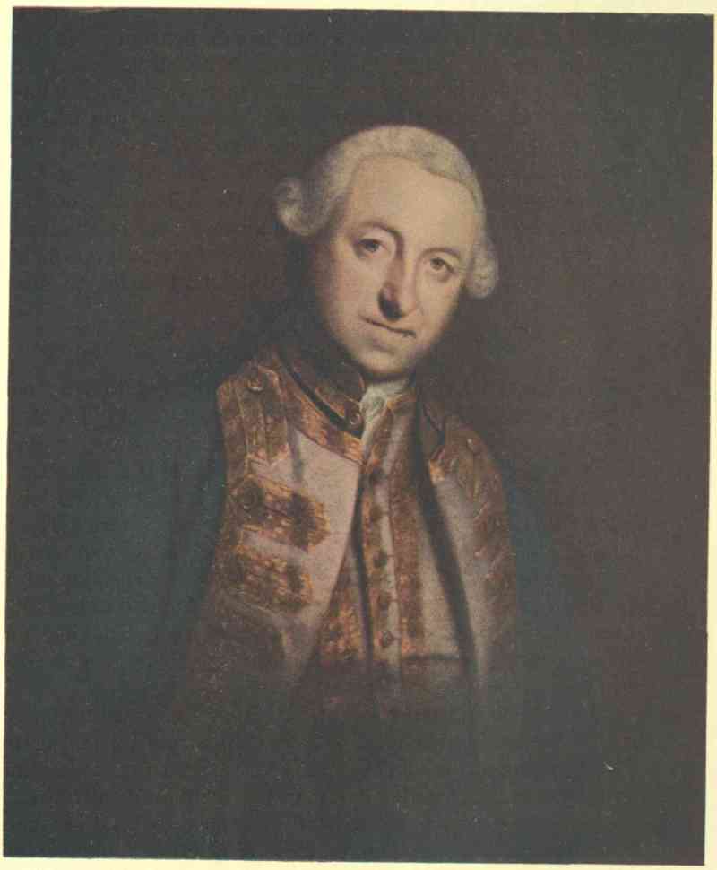
EDWARD BOSCAWEN
From the painting by Sir Joshua Reynolds in the National Portrait Gallery
The War Office, under Lord Ligonier, had lavishly supplied the expedition with materials of war. It had 140 pieces of artillery, 90,000 shot and shell, and 4900 barrels of powder. So generous was the supply that, although the siege lasted nearly three times as long as Wolfe thought it should have done, only one-third of the powder was consumed.
The defence of the town was conducted by the governor, the Chevalier de Drucour, a sea officer of standing and character, but entirely without military experience. The force under him consisted of 4 battalions of regular troops, 2 companies of artillery, and 24 companies of colony troops from Canada, in all over 3000 men, supplemented by a few hundred militia of the town, and aided by bands of Indians. The supply of stores and provisions was ample. The naval force was 5 ships of war, mounting 340 guns, and 6 smaller vessels.
The English force outnumbered the French by four to one. It had a proper train of artillery. It was supported by a fleet overwhelming in strength. Unless, therefore, its investment could be prevented, both French and English knew that the capture of the town was inevitable. It was consequently the duty of de Drucour to prevent a landing, and, as the enemy, if successful, intended to proceed against Quebec, to protract the siege as long as possible. To this end the entrenchments along the shore, made in the previous year, were occupied and armed with guns. When the landing was finally attempted, two-thirds of the troops at Louisbourg were in these entrenchments, many of the soldiers having been in the encampments for more than a week in weather so bad that, from June 2, when the British fleet arrived, until June 8, there was no day on which an attempt to land was practicable. Indeed, on the 4th there was so fierce a gale blowing from the east that the British fleet and transports were in danger. Then, or on the next day, the French ships, doomed in any case to destruction or capture, might have hazarded, with telling effect, an attack on the investing fleet and its scores of transports.
Boscawen’s fleet and transports were anchored on a lee shore, a position in the highest degree disadvantageous for resistance to determined attack by a force bearing down on them with a favourable wind. The chance was seen and discussed in Louisbourg, but des Gouttes, the commodore, was unwilling to take the risk. After the enemy succeeded in landing, he and his captains wished only to escape from the doomed port. A council of war decided that the ships should remain to protract its defence, but, with one exception, they were handled without spirit, and eventually they were left to destruction, with only guards on board, while their crews helped in the defence of the fortification.
It was not until the early morning of the 8th that a landing could be attempted. Then the three divisions rowed towards the shore; that of Wolfe, to the extreme west, attacked the entrenchments at Freshwater Cove, the strength of which reconnoitrings had not disclosed. This position was protected by abattis skilfully disposed, and its guns were concealed behind freshly-cut spruce and fir trees, which were not removed until the moment of firing. This began as soon as the boats came within range. Had it been reserved until the troops had landed on the beach and become entangled in the trees, a slaughter as great as that of Ticonderoga might have followed. The fire of the batteries was so effective that Wolfe’s division, in answer to his signal of recall, began to draw off. The light breeze drove down on the entrenchments the smoke of their own and the enemy’s fire. Through this Wolfe saw—what was obscured from the French—that behind a ridge which bounds the eastern side of the cove, three boats under Lieutenants Hopkins and Brown and Ensign Grant had made good a landing on a narrow strip of sand among the rocks which was protected from the fire of the batteries. He dashed in to support them. Some little time was lost to the French by the fact that they were ignorant of what was passing on the other side of the ridge, and more, apparently, by the vacillation of Lieutenant-Colonel de St Julien, the commander of the force in the entrenchments, when he became aware of the fact that the enemy had landed. The first attack by skirmishers was beaten back by the British, and soon the invaders were strong enough to drive de St Julien and all the forces under him in disorder into the city.
The landing once made, it became on the one side a question of how quickly the town could be taken; on the other, how long that disaster could be put off. The presence of the ships in the harbour and the Island battery at the entrance, in Boscawen’s opinion, made an attack by the fleet impossible. Warren, a capable officer, would not attempt such an attack, although there were in his time no men-of-war to defend the port. On the other hand, the contempt in which the French military men held des Gouttes and most of his officers, as well as the subsequent ineffectiveness of his ships in defence, make it probable that their effect would have been much less than sound naval judgment had estimated. In consequence of the view that an attack from the sea at this stage was impracticable, Wolfe almost at once led a force to erect a battery at Lighthouse Point, to silence the Island battery, the chief defence of the port.
In the main the siege was carried on along the same lines as in 1745. The length of time from landing to surrender was, notwithstanding the different conditions, in the first attack forty-nine days, in this forty-eight. The ships in the harbour were sunk or captured, only one escaping. This was the Aréthuse, the most energetically handled of the fleet, for she alone had for many days impeded the siege works until dislodged from her advanced position. Sallies were made from the town, which inflicted loss on the besiegers, but the irregulars from Canada under Boishébert, from whom much was expected, failed signally even to annoy the enemy. The defences were broken down, the harbour was exposed to the fleet, ‘the whole a dismal scene of total destruction,’ when on July 26 the town, open to a general assault, was surrendered by de Drucour on the solicitation of its people. The keystone of the arch of French power in America had been shattered. It remained only utterly to destroy the arch, tottering to its fall, and from Louisbourg sailed, on June 6 of the following year, the Armada before which Quebec surrendered.
The incidents of the siege possess dignity and interest adequate to the importance of the event with which it closed. Notwithstanding the bitterness of this war, ‘Never,’ says one diarist, ‘was a siege conducted with more delicacy of feeling.’ There was the interchange of courtesies between the commanders, the solicitude to avoid injury to non-combatants, and the care of the sick and wounded; the light-hearted bravery of the young officers who made a landing, when Wolfe felt forced to retire, and the reckless courage with which Wolfe and his men rushed in to their support. There was, too, the courage of Madame de Drucour, wife of the governor, herself the daughter of a house famed in the annals of the French navy, who animated the defenders by her daily round of the fire-swept ramparts; of Vauquelin, commander of the Aréthuse, who redeemed the reputation of his service by his handling of his ship, and his skilful sortie through the blockading fleet; of the officers and men of the cutting-out expedition, which completed the destruction of the French squadron, and gained new laurels for the British navy. Louisbourg, too, furnished the first signal justification of the policy of Pitt in forming the new Highland regiments. While the young Pretender still lived they began, in the service of King George II, that splendid record to which each following campaign of the British army has added a new page.
After the fall of Louisbourg four British regiments were placed as a garrison in the fortress, and Brigadier Whitmore was appointed governor. Honours and rewards were heaped upon the naval and military commanders, and all England rejoiced at the capture of a stronghold which had been for years a menace to British trade with America.
But England had no intention of keeping up the Louisbourg establishment, and with the fall of Quebec it was decided to demolish the fortress. This was done for two reasons. The French attached the greatest importance to the place, and should war break out again, France would undoubtedly make a mighty effort to recover a stronghold which meant so much to her trade and her sea power. England, moreover, had no need of Louisbourg, as Halifax was now her naval base in North America.
In 1760 Governor Whitmore received orders to make the place untenable for troops. For five months an army of men toiled at the work of demolition. The walls and glacis were levelled into the ditch, and by the middle of October only a few fishermen’s houses, tumbled heaps of stones and shapeless mounds remained to mark the spot that had been the strongest artificial fortress in America.
In the fourteenth century France and England began their first Hundred Years’ War, a war which they were inevitably forced to renew, again and again, until the vital question of undivided sovereignty over the land of France had been settled beyond dispute. France was the stronger power on land, and so she ultimately won this long and decisive struggle. Two centuries and a half later France and England began another mighty conflict, which may be justly regarded as a second Hundred Years’ War, but which, from its nature and results, should be more aptly called the Great Imperial War. This time it was not the possession of any particular land that was the main object of contention, but rather the general command of the sea. Yet this change of object made no real difference in kind. The second war was inevitably renewed, like the first, at every crisis, till the command of the sea was settled as decisively as the actual possession of the land of France had been. But, in degree, there was a very great difference between the first war, which was waged within the limits of a single country, and the second, which was waged over every sea, seaboard and hinterland where the ubiquitous rivals crossed each other’s path.
This Great Imperial War includes the seven French and English wars between the accession of William III and the battle of Waterloo. But the only British threads of connection which ran unbroken throughout the warp and woof of all the complexities of these seven wars were sea trade, sea power and oversea dominion. So it was in 1692 that the web of Canadian destiny began to be woven at the battle of La Hogue, and in 1805 that it was completed at the battle of Trafalgar, a victory which confirmed the command of the sea so decisively as to make possible the British Empire of to-day. Trafalgar made the Empire a possibility, and the navy won Trafalgar. But this by no means implies that the navy did the work alone. Apart from the general civil resources of the Empire, which are not under discussion here, there was always the mercantile side of sea power, which was indissolubly connected with the naval side. Then, the navy itself was only one, though the principal, branch of a united service which always required the close co-operation of the army, which, in its turn, often required the assistance of militia forces, especially in the Canadian campaigns. Finally, all these component parts of war power could only become effective when they and the civil resources of the Empire were duly co-ordinated under the supreme direction of a competent statesman.
The fight for Canada has three claims to great and significant distinction on all these counts. First, it is at once the archetype and best example of all imperial British wars. Its principal causes and effects were determined by sea power. It required the co-operation of navy, army and militia. It raised every cogent question of the correlations of colonies and mother country in imperial defence. And it was carried out under the supreme control of the greatest civilian war statesman of that or any other age. Secondly, its crowning battle of September 13, 1759, on the Plains of Abraham at Quebec, was the central feature of the ‘Maritime War,’ by which apt name the British part of the Seven Years’ War was always known in contemporary England. And, thirdly, this ‘Maritime War’ was itself the central and most important phase of that Great Imperial War which settled the oversea dominion of the world.
The Treaty of Aix-la-Chapelle was really a truce to allow the combatants to recover their breath—a pause in the game to avert a stalemate. It settled nothing and satisfied nobody. The American colonists were furious with the home government for giving back Louisbourg, which they, with the help of Warren’s fleet, had captured in 1745. They chose to think that they had been sacrificed to the East India Company, as Louisbourg appeared to have been simply traded for Madras. But calmer insight would have shown them that France could have successfully invaded Holland, established a naval base there, and thus wielded a weapon dangerous enough to threaten the safety of the mother country even more than Louisbourg threatened them. The war had not been at all triumphant from the British point of view. But the mercantile marine emerged with great actual and greater potential strength; while the navy had increased to 126 ships of the line, in marked contrast to the French 31 and the Spanish 22.
In those days treaties had little effect beyond home waters, and hostilities often continued in colonies, dependencies and spheres of influence. In the East the French under Dupleix and La Bourdonnais were straining every nerve to found an Indian Empire, while Clive was beginning his career by defeating them. In the West they were trying equally hard to link Canada with Louisiana by taking permanent possession of the whole interior between the Great Lakes and the Gulf of Mexico. There was a general struggle of British seaboard against French hinterland. Thirteen disunited British colonies were instinctively feeling their way across the Alleghanies into the rich lands beyond; and two French colonies were trying to prevent them by ‘joining hands behind their backs.’ The British had Hudson Bay, Newfoundland, and the Atlantic seaboard from Nova Scotia to Florida. The French had Cape Breton and Prince Edward Island, the present province of Quebec, and a long chain of fortified posts further west, which they were trying to extend southward along the valleys of the Ohio and Mississippi. Their line was thus an immensely long inland semicircle, flanked by the Gulfs of St Lawrence and Mexico, which were open to naval attack, and subject, along its very thin south-westward extension, to the natural pressure of a pioneering population many times more numerous than its own.
The disputed borderlands were inhabited by Indians, who were still a force to reckon with. Naturally enough, the Indians, as a whole, resented the intrusion of all whites. Wherever white men went in bodies they were certain, sooner or later, to change the whole face of the country in a way abhorrent to the Indian manner of life. But the whites were very much stronger than the Indians, and thus compelled them to take sides, whether they would or no. The Indians, therefore, chose what appeared to them to be the lesser of two evils for the time being. Both white races constantly accused them of treachery. But they simply fought for their own interests, just as the dominant whites did for theirs. In making up their minds the Indians looked at the three main chances which always affected them—which race was the more congenial, which was the better one to trade with, and which one was going to win.
The first question was almost invariably answered in favour of the French. Partly because of their pleasanter manners, partly because of their greater adaptability, and partly because of their very failure to grow as a colonizing power, the French nearly always proved the more naturally attractive to the Indian. The French-Canadian habitants were only some sixty thousand, and they were mostly settled on the banks of the St Lawrence, without any decided tendency to expand into the hunting grounds. The French officials made much of the chiefs at all the ceremonial pow-wows, and their flowery rhetoric was always acceptable, as somewhat akin to Indian oratory. The French missionaries had been first in the field, were unsurpassable in heroism, and, with all their devotion to their God, had never forgotten their king. The ‘wilderness’ French, too, were still less uncongenial. They loved war and the chase and the fur trade like the Indians, with whom they often intermarried; and they were so few and so nomadic that their presence rarely threatened to upset the existing order of things to any unwelcome extent.
The American colonists, on the other hand, were nearly always uncongenial. They were an expanding race of farmers, uprooting and destroying the Indians like weeds wherever they went. One of their pioneers was soon followed by a dozen, and these by a hundred, and so on, till the red man was completely displaced. Even in the untamed wilderness the American was no more congenial than the British officials in the towns. The one really notable exception was Colonel (afterwards Sir) William Johnson, an Irishman who loved the Indians as they loved him, who never cheated them in trade, spoke Indian fluently, became a Mohawk war-chief, and marched into Albany in 1746 at the head of the tribe, dressed up and painted like the others, and singing the war-song with the best of them. Nor was this all. Some time after his wife’s death he saw a Mohawk chieftain’s daughter, the beautiful young Molly Brant, witching the little backwoods world with daring horsemanship, and then and there took her to live with him for the rest of his life. He became the universally trusted counsellor and friend of all the Indians on the British side, and stood high in the confidence of the authorities. He was a most remarkable man, equally at home at court or in the wilds—which is probably one reason why he was so successful with the Indians. But he was an exception. And his exception proves the British rule.
Decidedly, the French were the more congenial to the Indians. But which was the better race to trade with? Both French and British cheated as a general rule, and both were, of course, entirely devoid of conscience about the liquor traffic. But the French trade, always hampered by government restrictions, was still more adversely affected by the British command of the sea, before which it finally withered away, while its rival ultimately triumphed.
The last and most momentous question was, which side is going to win? Owing to various causes, of which congeniality was always the principal, the Indians, who knew nothing of the outside world, were generally inclined to believe more in French than in British prowess, especially as the French understood so much better how to make the greatest show of whatever force they had. So in this, as in other questions, the bulk of the Indians threw in their lot against the British and with the French.
Within a year of the treaty the French governor, La Galissonière, sent Céloron de Blainville to claim the Ohio valley for the crown of France. But at the very same time the British Ohio Company obtained a grant of half a million acres in that region, and the next year, 1750, sent the trader, Christopher Gist, to prospect for them. In 1751-52 they began to follow up their claims; while in the latter year the French took the British post at Pickawillany, near by, to secure their position at Detroit. After the two frontiers had thus crossed each other there could be no more peace on either side. In 1753 Governor Duquesne sent the Canadian officer Marin to build forts along the upper Ohio. In October of the same year Robert Dinwiddie, governor of Virginia, sent a sort of diplomatic mission to protest against this encroachment. The British envoy was George Washington, then a young surveyor of twenty-one, who had been befriended and employed by Lord Fairfax, the owner of five million acres in Virginia. Sixty miles north of the modern Pittsburg he saw the French flag flying over a British trader’s house at Venango, now Franklin. Joncaire, the French officer, received him ‘with the greatest complaisance,’ and that night, after some heavy drinking, ‘They told me, That it was their absolute Design to take Possession of the Ohio, and by God they would do it: For that altho’ they were sensible the English could raise two Men for their one; yet they knew their Motions were too slow and dilatory to prevent any Undertaking of theirs.’
Dinwiddie resolved to strike back, and again selected Washington, this time as a militia officer in command of a hundred and fifty men under orders to garrison the British fort which was being built at the Forks of the Ohio, where Pittsburg now stands. But while still crossing the Alleghanies Washington heard that Contrecœur had just taken the fort with an overwhelming force. The French immediately set to work to improve their position, renamed it Fort Duquesne, and sent a detachment under Coulon de Jumonville, as a corps of observation, to see what Washington was doing, and to deliver to the English a summons requiring them to withdraw from the domain of the king of France. Washington took up his position at the Great Meadows, on the western foot-hills of the Alleghanies and about fifty miles from Fort Duquesne. Presently a friendly Indian told him that the French force could be surprised in a ravine within a few hours’ distance. He at once set out, marched through the dense woods all night, and attacked the French at dawn. Jumonville was killed, and only one of his men escaped either death or capture. Warned by the Indians that a much stronger French force was coming against him, Washington fell back on the Great Meadows and entrenched himself in what the condition of his men induced him to call ‘Fort Necessity.’ He had not long to wait, for de Jumonville’s brother, Coulon de Villiers, was hastening to avenge what the French called the ‘murder’ of an ‘ambassador.’ Nine hours of desultory firing in a downpour of rain convinced Washington that his men could not hold out against such a superior force, and he sent Captain Van Braam to arrange terms in reply to the summons of de Villiers. Van Braam, in reading aloud the French articles in English, without a good knowledge of either language, translated ‘l’assassinat du Sieur de Jumonville’ as ‘the death of Sieur de Jumonville,’ and Washington, who was listening on the other side of the sputtering candle, accepted the terms as he then understood them. The next day Washington marched out with the honours of war, leaving Van Braam and Stobo as hostages for the due return to Fort Duquesne of the French prisoners taken when de Jumonville was killed. The French now had the Ohio to themselves, with a strong base at the Forks, and a greatly increased prestige among the Indians.
Meanwhile the common danger had at last induced seven of the colonies to send commissioners to a conference at Albany with the chiefs of the Iroquois. Hendrick, the famous sachem of the Mohawks, spoke the Indian mind with unpalatable plainness and truth. Taking a stick and throwing it over his shoulder he said, ‘This is the way you have thrown us behind you. . . . The Governor of Virginia and the Governor of Canada are quarrelling about lands which really belong to us, and their quarrel may end in our own destruction.’ A liberal distribution of presents mollified some of the Indians. But they were still distrustful; and small blame to them; for, while the conference was actually in session, two land companies obtained grants without the consent of the occupants, who were naturally embittered against the British more than ever. The conference led to no better practical result in another important direction. Some sort of union for the common defence of the frontier was felt to be necessary. Its urgency had been graphically illustrated in the Pennsylvania Gazette by a woodcut of a snake cut into thirteen pieces, representing the disunited colonies, with the significant motto underneath—‘Join or Die.’ Benjamin Franklin records in his Autobiography that his own plan of union ‘happen’d to be preferr’d . . . the general government was to be administered by a president-general, appointed and supported by the crown, and a grand council was to be chosen by the representatives of the several colonies, met in their respective assemblies. . . . Its fate was singular: the assemblies did not adopt it as they thought there was too much prerogative in it, and in England it was judg’d to have too much of the democratic.’ The net result was that the British authorities on both sides of the Atlantic were stirred to action; but only to action of the old disunited kind.
The home government had sent out Braddock, a general of the bulldog type, and a couple of regular battalions, to lead the local militia in reasserting the British territorial claims. In April Braddock arranged with the principal governors to make a fourfold attack on what the British called French encroachments. Braddock was to attack Fort Duquesne; Shirley, Niagara; Johnson, Crown Point; and Monckton, Fort Beauséjour. Fort Duquesne and Fort Beauséjour were unquestionably on disputed ground, and attacks on them would, from the British point of view, be only the eviction of intruders. But as the French had held Crown Point for over a quarter of a century, and Niagara for quite three-quarters, they might certainly claim that attacks on these points constituted open war.
Braddock laid out an extensive plan for his own force. After taking Fort Duquesne he was to march north to join Shirley at Niagara, and then east to Crown Point, in case Johnson required his support. But he had reckoned without the obstacles from friend and foe. The colonial assemblies were nearly always at loggerheads with the imperial authorities on both sides of the water. They would not join together to defend themselves, though they could not defend themselves if they did not join together. Much less would they place their resources at the disposition of the home government. What they really wanted was thirteen separate little armed mobs, separately controlled by the thirteen little assemblies, and paid for entirely by the home government. But narrow, selfish, and contemptibly unstatesmanlike as they nearly always were, they were not the only ones to blame. The home government was often crassly inattentive to many personal points on which it might have pleased the more sensitive colonials instead of exasperating them—for instance, the vexed question of relative rank between regulars and militia. It frequently hesitated, blundered, and got lost when balancing the relative importance of world-trade, British interests, and colonial expansion. Trade, empire, colonization—these three have never been harmonized completely, not even in the twentieth century; so who can blame a failure under the more difficult conditions of the eighteenth? But 1755 was a bad year, even for the eighteenth century; and the worst colony in this worst year was Quakerish Pennsylvania, always ready for peace at any price to others and any advantage to itself. Its Moravian missionaries were men of peace; but they upheld their principles with their lives, and set a noble example of kindness towards the Indians; whereas the trading Quakers simply lived as parasites in a land which owed its existence to the sword. Besides, on occasion, they would shrink from their principles as much as they always shrank from their proper share of the burden of defence; for in 1764 they actually took up arms against some of their own fellow-countrymen who threatened Philadelphia.
A great deal more energy was wasted in friction between the fourteen governments than was directed in armed strength against their common enemy. But at last Franklin, by a happy exercise of business ability, got enough transport together, and Braddock started. In the middle of May the British force of two thousand men was at Fort Cumberland, one hundred and thirty miles from Fort Duquesne, which Contrecœur had just completed. Half Braddock’s men were well-drilled regulars, a quarter were colonials recently enlisted to recruit their ranks, and the remainder were militia. Washington had gladly accepted Braddock’s invitation to be his aide-de-camp; and there were other local officers who knew the country and the kind of warfare to be expected. But Braddock paid little attention to their warnings, and thought the European methods would certainly prevail over any American conditions. Yet there is this excuse for Braddock—the government he served had shamefully neglected all preparation for war, even in Europe; it had never studied American conditions, but sent out its troops utterly untrained and unequipped to meet them; all he had hitherto seen of American ways was bad; and he was a mere mediocrity, not a genius. Progress was slow, and the road-making was unnecessarily elaborate, while the scouting was poor. It was July 7 before Braddock reached Turtle Creek, some eight miles from Fort Duquesne, with twelve hundred of his best men.
Meanwhile the French were getting anxious at the approach of a force whose strength had been much exaggerated by rumour. Contrecœur decided at last to send out an ambuscading party of 36 officers and volunteer cadets, 72 regulars, 146 Canadians and 600 Indians of a dozen different tribes. Captain de Beaujeu was in command, Captain Dumas, well known in later campaigns, was second, and Captain Langlade, who had taken Pickawillany three years before, was again leading his irregulars. The Indians, of course, were perfectly versed in every shift and expedient of bush fighting. They took cover instinctively, could keep touch when very widely extended, and never lost their sense of direction. The French and Canadian partisans imitated them to good purpose, and sometimes surpassed them in effectiveness at their own war game. The British regulars, on the other hand, having been trained for quite a different kind of campaign, only made themselves a better target when they massed, and lost their cohesion when they extended. When given the chance they learnt their new lesson well enough. But those under Braddock would have been more at home if suddenly told off to man a ship in action than they were when marched straight from the barrack to the bush.
July 9 was a perfect summer’s day, and Braddock’s men made a brave show of brilliant scarlet and bright steel as they marched towards Fort Duquesne in close formation, so as to impress the enemy with a due sense of their irresistible strength. Suddenly an engineer sighted Beaujeu, who wore a gaily-fringed hunting-dress, and who immediately waved his hat as a signal to his followers to take cover right and left. A British volley killed Beaujeu, and this so dismayed the Canadians that some of them ran away. Then the British guns opened fire, and the Indians also began to run. But the French regulars stood firm; the Canadians and Indians were rallied, and the fight was resumed. No formal body of the enemy ever appeared; but presently the surrounding forest was alive with unseen sharp-shooters, picking off the British with alarming rapidity and ease, while themselves apparently invulnerable against the steady volleys the regulars were giving in return.
There stood the dense red lines, in the full glare of the midsummer sun, like a living wall fronting a battering train: continually breached, as the men fell fast in every part of it, yet continually repaired, as others took their place. Braddock was furious with the Virginian rangers for taking cover and ordered them into line, where they were shot down like the rest. He exposed himself fearlessly in a vain effort to keep the formation, and had no less than four horses shot under him. But the slaughter soon became more than flesh and blood could stand. The ranks quivered, wavered, caved in and melted into a shapeless red mass under a redoubled fire from all quarters. Just then Braddock was mortally wounded and, realizing the hopelessness of his position, gave the signal for a retreat from which hardly a man would have come out alive had the French pressed home the pursuit. As it was the loss was immense. Only a quarter of the force escaped unhurt. Out of eighty officers sixty-three were killed or wounded. The French loss was equally remarkable, but in the opposite way, as it barely amounted to one-tenth of that on the British side. The victory and defeat were both decisive, and made a profound impression everywhere. The British frontier shrank back into the Alleghanies, and the French remained the undisputed masters of the whole of the Ohio valley.
Shirley’s expedition to Niagara met with no such disaster, but it was a dead failure nevertheless. It only reached Oswego towards the end of August, and after a month there decided not to advance against Niagara, since the French at Frontenac (now Kingston) were watching their chance to slip into Oswego, from which, as was well known to both sides, Shirley’s half-mutinous provincials could never turn them out. A garrison of seven hundred was then left behind, and the rest marched home.
Meanwhile Johnson, like Shirley, had rendezvoused at Albany, where they both remained long enough to march off on their own expeditions under the shadow of Braddock’s defeat. Johnson was a much-commissioned major-general, as every colony that sent him any men made him a major-general to command them. The raw militiamen came in slowly, everything lagged, and only Johnson’s popularity kept the impatient Indians from deserting. Dieskau, the French general, had learnt the British plans from papers taken at Braddock’s defeat, and changed his own, against Oswego, in order to meet Johnson near Lake George. Each side had about three thousand men all told, but the French alone had regulars. Had there been more of these the result might have been very different. But Boscawen had captured two French transports in the gulf, enough to turn the scale of victory ashore. Dieskau was naturally emulous of the French success at Fort Duquesne and, thinking the enemy’s main body was falling back on Albany, took a picked force from Ticonderoga down to the southern end of Lake Champlain, where he landed for a surprise attack on Fort Lyman, twenty miles across very difficult country. Johnson, hearing of this, sent a message to the fort. But the French Indians shot the messenger, and Dieskau then found out that Johnson’s main body was still at the southern end of Lake George, no further to the right than Fort Lyman was to the front. Dieskau wanted to push on to seize and hold the fort. But the Indians refused to face the big guns they thought were mounted there; and Dieskau had to turn back to attack Johnson’s much superior numbers on even terms. The French had 1500 men, of whom only 220 were regulars. The rest were Indians and Canadians in equal numbers. The British had about 1000 more. On hearing of the French advance Johnson sent Colonel Ephraim Williams with 1000 men to meet them. This force walked into an ambush much as Braddock had done two months before. Williams and Hendrick, the Mohawk chief, were killed. But as the provincials took cover and retreated much faster than the red-coats had done at Fort Duquesne they suffered correspondingly less. Still, this preliminary fight was long known in New England as ‘the bloody morning scout.’ When Johnson heard his men retiring he finished his preparations for defence, laagering his wagons and placing his guns to sweep the main approach. Dieskau lost a golden opportunity of rushing the enemy on the heels of Williams’s men, because he had to wait to form his own, who had now got somewhat out of hand. This gave the enemy time to pull themselves together and receive him with a steady fusillade. The French regulars and Johnson’s guns began the fight, which soon became furious on both sides. Johnson and Dieskau were wounded. Lyman succeeded Johnson, but Dieskau continued in command. Numbers and position began to tell. The French attack weakened, and the triumphant provincials, jumping over their own barricade, rushed to the counter attack. The Canadians and Indians gave way at once; but the little knot of French regulars held their ground, and most of them were clubbed to death as they stood at bay. Dieskau, four times wounded, was taken prisoner; and his shattered army fled through the woods back to South Bay. The reunited French then fortified themselves at Ticonderoga, while Johnson built Fort William Henry on the ground he had won. His reward was a baronetcy, £5000, and the thanks of parliament. Lyman, who was at least equally deserving, got nothing. The news of this unexpected victory revived the spirits of the Americans, and naturally made them think still more of their own men and still less of the red-coats.
Another British success, but of a pettier kind, was the surrender of Fort Beauséjour in Acadia. Vergor, its commandant, made only the feeblest resistance. He was one of the worst of the corrupt kind of colonial officials, and repeated his disgrace four years later when, through his carelessness, Wolfe’s men were allowed to climb the heights at Quebec unopposed.
The remaining act of war was the expatriation of the Acadians. These people had passed under British rule after the Treaty of Utrecht in 1713. They had repeatedly refused to take any binding oath of allegiance. Their sympathies were naturally with the French. They were strongly influenced by the Abbé le Loutre, who left no means untried to keep them hostile to the British. And some of them had been found among the garrison of Fort Beauséjour. They were, in themselves, neither better nor worse than other men, and it was not their fault that they were living between two jealous rival powers at a very critical time, when each had to use all legitimate means of strengthening itself and weakening its opponent. Yet they undoubtedly were a potential factor on the French side, and so unfortunately situated as to be a very dangerous menace to the British. The treaty of Aix-la-Chapelle had left the Acadian boundaries unsettled. Commissioners sat for years at Paris trying to make a delimitation. But before the commission began its labours the French occupied some of the disputed territory on the neck of the Acadian peninsula, where they built Fort Beauséjour. The fact was that the French and British were manœuvring for position all along the line, and the Acadians could not be neutral, even if they had so wished. Acadia was an outpost of the French in Canada, a landing-place for the French from Europe, and a living link between the two. The Acadians had been mildly ruled for forty years—as is unintentionally proved by the pictures of their happy life, drawn by the compassionate school of writers. But since this did not turn them into friends, and since they could not safely be allowed the chance of turning into active enemies, they had, perforce, to be rendered neutral. A sparse population could not be interned as it stood. A concentration camp was impracticable. So deportation was the only alternative. In any case, this would have been a rough-and-ready expedient, as time pressed and means were scanty. But it certainly was carried out with needless brutality, families being broken up and scattered about indiscriminately all over the British Colonies, each of which tried to shift this unwelcome burden on to its unwilling neighbours. On the whole, the expulsion of the Acadians was a quite justifiable act of war, carried out in a quite unjustifiable way.[1]
Thus 1755 closed in America with the balance of military advantage decidedly in favour of the French. The naval scale, however, inclined in favour of the British. The irresolute cabinet had not given Boscawen full information and a free hand. Consequently, he failed to bring the French fleet for Canada to decisive action, as he should have done, on the sound principle of striking hard or not at all before a declaration of war. Yet he and Hawke, who captured three hundred French vessels on the high seas, did good service in clipping French wings on both sides of the Atlantic.
|
Parkman has taken the same view; but it can be and it has been disputed. Deportation in war time has been resorted to by other powers. But is it justifiable? That is the question. For the opposite side on that controverted point, the reader may consult Abbé Casgrain’s Un pèlerinage au pays d’Evangéline, and Richard’s Acadia. (Note of the special editor.) |
The formal declarations of the motherlands against each other were fine specimens of the mutual recrimination common on such occasions, and showed the prevailing national attitudes to a nicety. The French pose before what they conceived to be the attitude of civilized Europe was well matched by the stolid self-righteousness of England.
The two powers differed so profoundly in the nature and application of their armed forces that a general comparison is almost impossible. In area, population and natural resources France greatly surpassed England, and, indeed, the British Isles. Its army was more than twice as strong, all things considered. But in government, the navy and external trade the British were easily first. Not that the British government of 1756 was a good one, not that it was by any means free from corruption, and not that its successor in 1763 was any better; but that the French were decidedly worse. Their previous reign had seen at least one generation of military glory under an absolute king. The succeeding reign was to end in a revolution which, with all its evils, was to produce a marvellous development of warlike strength. But in the long interval between the ‘Roi Soleil’ and Napoleon the faculty of national leadership was numbed by corruption and perverted by misgovernment. In naval power England, as usual, had been losing ground during peace, while France, also as usual, had been recovering it. Still, the British fleet could put about one hundred ships into the line, at fairly short notice, against about forty-five on the side of the French. Roughly, it may be said that as the French army was twice as strong as the British would ultimately make theirs, so the British navy was at least twice as strong as was the French at the start. The other great powers who took part—Prussia, Austria and Russia—did nothing to alter the balance at sea. Spain, which had a fleet, was both too weak and too late to be of real use. In the mercantile branch of sea-power the British were very much more pre-eminent. All the staying power was on their side. Every one of their naval victories made the sea safer for their own trade and more dangerous for the enemy’s; until theirs reached a height of prosperity it had never attained in time of peace, while the enemy’s withered away to almost nothing. What made the difference all the more decisive was that every increase of British sea-trade increased the national resources convertible to warlike ends, and of course correspondingly decreased those of the French. This was nowhere more felt than in Canada, where money, supplies, reinforcements, trade, and even presents for the Indians, all failed at their source when cut off from the sea.
The French position in Canada was, therefore, a weak one in a general way, as the line of communication with the base passed over a hostile sea. Yet it had several elements of local strength, which, if turned to better account, might have staved off the conquest long enough to give France another opportunity of holding her own in America by European diplomacy. The country was a natural stronghold, except for its easy access from the sea. But even the St Lawrence was quite defensible. The land lines of invasion were all much more so. The direct approach to Quebec by the Chaudière river was exceedingly difficult, especially for a large force. The line of Lake Champlain offered many opportunities of water transport from New York to the St Lawrence. But the portages and several other places, if fortified, could be held against greatly superior numbers. And though a land of waterways might be supposed to offer the general advantage to the British, this was not then the case in Canada; for the French were in possession of the whole line of the St Lawrence and the Great Lakes, except at Oswego, which they soon captured. In canoe and bateau work on inland waters they had nothing to learn from their rivals. Thus the country was particularly strong against any inland invasion, which of course could only be effected along a few definite lines, and not through the immense wilds, which practically barred the way to considerable armies.
The French forces in Canada were generally fitted for their task. The militia was composed of all the able-bodied men in the colony. These men could rough it, march and shoot; but they were not well disciplined or drilled, and were of little use at close quarters in the open. Including old men and quite young boys they never mustered twenty thousand, and nothing like this number could take or keep the field in a body, as that would bring all the civil work of the country to a standstill. Even in smaller numbers they could not be kept long under arms in seeding-time or harvest. The troupes de la marine were companies of colonial regulars under the administration of the department of Marine. But they were soldiers pure and simple. They came mostly from and sympathized with the militia, and, like them, were trained for bush-fighting. They never numbered much over two thousand effectives and were rarely formed in any higher unit than the company. The backbone of all the forces was the troupes de la terre or regulars from France. The officers, as a class, were not professionally equal to the Prussians—neither were the British. But, taken for all in all, the French regulars in Canada would bear comparison with any others of their day; and they upheld the best traditions of their most military nation. Seamen as combatants were oftener employed ashore than afloat: there never was any naval battle worth the name in Canada. The numbers varied, but probably never exceeded fifteen hundred at any one time, exclusive of those at Louisbourg. The last force was the Indians, most of whom, except the Iroquois, took the French side. They were, in every sense of the word, a fluctuating quantity. Altogether, it is safe to say that the very utmost strength which could ever be mobilized could not exceed 25,000 men, greybeards and boys, all told. Of these, not 5000 at the outside would be French regulars, 2000 Colonial regulars, 1000 seamen, 14,000 militia and 3000 Indians. And it is doubtful if all the real effectives ever exceeded 20,000 in the whole theatre of operations.
But these 20,000 were led by Montcalm, in every way a splendid leader and by far the greatest Frenchman in the whole New World. He was of illustrious birth. His family for centuries had been so famous in the field that there was a well-known saying, ‘La Guerre est le tombeau des Montcalm.’ He had remarkable aptitude for the intellectual life as well as for soldiering, and might have aspired to a seat in the French Academy as well as to a marshal’s bâton. He was born in 1712, succeeded to the marquisate in 1735, and the next year married Angélique Talon du Boulay, a blood relation of the famous Jean Talon, intendant of New France, in 1665. His military career had been a most distinguished one. Ensign at fifteen, he fought at Kehl and Philipsbourg in the Polish campaign. In 1741 he was aide-de-camp to the Marquis de la Fare in Bohemia, where he won the cross of St Louis. Colonel in 1743, he twice rallied his regiment in the French defeat at Piacenza in 1746, received five wounds and was taken prisoner. After six years of peace, mostly spent at his beloved family seat of Candiac with his wife and children, he accepted the Canadian command, after it had been pressed upon him twice, set out for Paris, studying Charlevoix’ History of New France, had audience of the king, promptly settled his military affairs, sailed from Brest in the Licorne, had a stormy passage of thirty-eight days, landed at St Joachim, and drove the remaining twenty-five miles to Quebec in a calèche, arriving on May 13.
Vaudreuil, the governor-general, was anything but pleased to see Montcalm. These two men were utterly incompatible. Vaudreuil was a vain and fussy pettifogger, who had constantly reported home against having any French general sent out, in order that he might have no expert check on his own ridiculous leadership. Unfortunately, he had the right of supreme command whenever he chose to exercise it. And he alone could command all the five different kinds of forces—French regulars, colonial regulars, seamen, militia and Indians. He could delegate his authority; but he never gave with one hand without taking away with the other. His character developed as the war went on, and always for the worse. The best that can be said of him is that he was more fool than knave. But Bigot, the intendant and head of the civil administration, was all knave. His character, too, grew worse and worse as time went on.
Even at first Montcalm realized his unfortunate position. Technically, he only commanded the French regulars. The seamen were under their own officers; the rest more directly under Vaudreuil, who was also commander-in-chief. Yet Vaudreuil, Bigot and Montcalm could all report direct to France. Thus there were five distinct forces under three different heads. It was the autocratic system without the autocrat on the spot. Moreover, transport, and even the horsing of guns, was done by civil contract, and, of course, always badly and dishonestly done by Bigot’s underlings.
However, things went fairly well at first. There was work ready and waiting; and, for once, all the authorities agreed that the taking of Oswego was the best way to open the regular war. Four battalions of troupes de la terre had come out in 1755. Two more arrived in 1756, and two more yet in 1757. Their names have become famous in the history of war—Guienne, Béarn, Languedoc, La Reine, La Sarre, Royal-Roussillon, and two battalions of Berry. The average effective strength of each was only about 500, making 4000 in all. The artillery from France was never very numerous, and there was no cavalry. One great advantage was that the men all embarked in high good humour. The Canadian campaigns attracted the French army even more than they had ninety years before when the Carignan-Salières went out with de Tracy, fresh from their victories over the Turks.
Meanwhile preparations for war were going on among the British in America. Shirley, an energetic man but not a general, was first appointed, and then superseded as commander-in-chief by Lord Loudoun, who happened to be a general but certainly was not an energetic man. Under Loudoun were Abercromby and Webb. Loudoun never did anything decided, Webb as little as he could, and Abercromby invariably made mistakes. Shirley’s plan was the comprehensive one of taking Fort Duquesne and the French posts along Lake Ontario, surprising Ticonderoga early in the year by an expedition across the ice, and threatening Quebec itself from the line of the Chaudière. But Shirley had to hand over the command to Webb, who handed it over to Abercromby, who handed it over to Loudoun. Loudoun forwarded the preparations as much as he could. Seven thousand New York and New England levies, under Winslow, gathered and advanced against Ticonderoga in the summer; but they never got further than the line of British forts. At the end of June Abercromby arrived at Albany, where Shirley urged him to strengthen Oswego. But he kept his men busy digging trenches at Albany instead. At the end of July Loudoun also arrived, upset Shirley’s plans altogether, and issued an order that no provincial officer should rank higher than a captain in the regulars. Even Loudoun saw the unwisdom of putting men who had shown a certain ability as generals—like Johnson, Lyman and Winslow—under some possibly muddle-headed major who had never seen active service. But mere politicians were ordering such things at home, and the Great Statesman was not yet wielding the forces of the Empire. No wonder Pitt was writing ‘I dread to hear from America’!
While the British colonies were as disunited and cantankerous as usual, the British home government even more than usually obtuse, and Loudoun marking time with twelve thousand men, the French were up and doing. In March Vaudreuil sent an expedition which destroyed Fort Bull, a post on the line between Albany and Oswego. In May he sent Coulon de Villiers, Washington’s victorious opponent at Fort Necessity, to intercept the British supplies for Oswego. This raid was partly successful. But Bradstreet, an excellent colonial officer, had a successful brush with some of the raiders and learnt the French plans and strength from a couple of prisoners. He at once reported to Loudoun, who thought over it for a month, and then sent Webb forward when it was too late.
Montcalm had picked up the threads of his complicated work in May. In June he had hastened to the defence of Ticonderoga, where he had left a garrison to safeguard it against Winslow. In July he was preparing his counterstroke against Oswego. New to the country, its ways and men, he was at first inclined to doubt his ability to take the fort with the means at his disposal. On July 20 he wrote to the minister of war in France saying that he could not make sure that the details were being properly combined before he had to leave Montreal for Frontenac. On his way up he stopped to parley with the Iroquois chiefs at La Présentation, from which place he sent them back to Vaudreuil, who kept them under surveillance, as no one knew which side they would take. On the 29th he was at Frontenac, where his men were cheered by the news of de Villiers’ raid at the beginning of the month. His advanced guard had already landed at Niaouaré Bay, now Sackett’s Harbour, which was the appointed rendezvous of his whole force of 3000 men, half regulars, half militia, with 250 Indians. On August 8 all were concentrated there, and he marched to surprise Oswego, moving by night, and hiding his men and material by day. Towards midnight on the 10th he arrived within striking distance, began a battery on his right, and camped between it and a protecting marsh on his left. There were three forts at the mouth of the Oswego, one on the right bank, Fort Ontario, one opposite on the left, Fort Oswego, and a third half a mile further on, Fort George. The garrisons numbered 1700 men. Fort Ontario was untenable against siege artillery, its twelve guns were soon put out of action, and its garrison crossed over to Fort Oswego, on which Montcalm immediately concentrated his attack. Fort George was small and weak and of no use to either side. The 1700 provincials—partly more or less seasoned men, partly raw recruits—had a good fort, thirty-three guns, and a capable leader, Colonel Mercer. But Mercer was no match for Montcalm, who opened his batteries across the river at 450 yards, and sent his Canadians and Indians over and round to attack in rear. Mercer was killed, the garrison became demoralized, and there was no news of Webb’s reinforcements. On the 14th the British capitulated, and surrendered 1600 men, 121 guns, plenty of ammunition, and the 6 armed vessels and 200 other craft prepared for Shirley’s proposed expedition against Niagara and Frontenac.
The capture of Oswego was the most consummate feat of arms in living memory among the colonials and Indians. Its strategical significance was evident to all. It secured the inland line to Louisiana, with both sides of all the great waterways. When Montcalm destroyed the fortifications he gained the goodwill of the local tribes as surely as he had impressed them by his victory. They naturally argued that while the British had come to alter their way of life, the French would let it take its own course again by leaving them alone.
Thus the opening year of the war ended badly for the British cause in every respect. Colonel Armstrong found three hundred fighting-men in Pennsylvania to follow him in a successful raid on the Delawares between Venango and Fort Duquesne. But the French Indians who took the warpath all along the frontier did far more damage in return. There had never been a better season for what some grim wags called ‘hairdressing.’ It is said that an Indian who had killed the French engineer at Oswego by mistake actually made amends by lifting no less than thirty-three British scalps within the succeeding twelvemonth.
There was no better news for the British from the East than from the West—this was the year of the Black Hole of Calcutta. And at the centre of world-power the prospect seemed equally bad. Frederick the Great had overrun Saxony and beaten the Austrians. But armies were gathering against him, in one long enveloping crescent, from Paris to St Petersburg. Hanover was in imminent danger, to the great distress of George II, and the double alarm of the cabinet, the weaker members of which wanted to hire Hanoverians for the defence of England against a French invasion. And France, with an eye to a future Spanish alliance, had taken Minorca, from which the governor and thirty-five officers, in a garrison of three thousand men, were absent on leave. Worst of all, a British fleet under Byng failed to retrieve the situation. This stung England to the quick. Byng was shot—the mediocre victim of a mediocre system and a mediocre ministry—and a ‘cargo of courage,’ under Hawke and Saunders, was sent out to replace him. Strangely enough, the French admiral, La Galissonière, was an ex-administrator of New France, Saunders commanded the British fleet in Wolfe’s campaign at Quebec, and Hawke’s clinching victory in Quiberon Bay sealed the fate of New France. In view of the complete triumph of the British arms three years later, the despondency and panic in 1756 seem almost incredible. But they were very real; and men’s hearts failed them when they felt the ship of state in the grip of the storm without any trusted pilot at the helm.
The European campaign of the year 1757 did not open auspiciously for the British side. Frederick won at Prague, but lost at Kolin, and had to evacuate Bohemia. The Duke of Cumberland, at the head of the most considerable British force that had appeared in European war since the time of Marlborough, was defeated at Hastenbeck and rounded up at Closter-Seven, where he signed a convention neutralizing his whole army for the rest of the war. A joint naval and military expedition sent to destroy the French stronghold at Rochefort—a west-coast harbour of great importance between the European and American fields of operation—ended with less disaster but equal disgrace. Hawke was the admiral, and, as his whole career proves, was quite capable of doing his part well. But the three incompetent generals could not make up their minds to do anything at all. After gravely deliberating for five days, in presence of their enemy, over what was intended to have been a surprise, they decided that, as he must have had ample time for preparation, it would be better to let him alone! However, the fate of Byng may have spurred them to at least a show of action; for, after another two days, they ordered an immediate landing in full force. After watching their men sitting idle in the boats for three hours, their hearts again misgave them, and they sailed home with the infamy of a complete fiasco clinging round their names for ever. The one redeeming feature was that a young staff-officer of thirty, Colonel Wolfe, took in the situation at a glance, quite understood how the army should have co-operated with the fleet, and attracted the favourable attention of the great Pitt by the marked ability with which he gave his evidence at the subsequent court-martial.
Meanwhile, Loudoun had been busy thinking out a counterstroke to Montcalm’s capture of Oswego. His plan was to take Louisbourg early enough to go on to Quebec and finish the campaign there. Pitt was in office for the winter months—much to the disgust of the common run of politicians—and the plan was approved. The money was voted, and in March the city of Cork was alive with the men of the joint expedition being made ready to sail against Louisbourg. Loudoun, on his part, held conferences with all the colonial governors, and, uninspiring as he was, found a good deal of popular support for a scheme which would wipe out the memory of the hated retrocession nine years before. But there was a political crisis in England. Pitt was dismissed for over-efficiency in April; and during eleven weeks of disastrous war there was no imperial ministry. Admiral Holborne’s fleet was still at Cork; and of course all the information concerning it had been reported to headquarters in France, whence strong squadrons were immediately sent out to Louisbourg. Even Loudoun was getting anxious to make another preparatory move when he and Admiral Hardy had rendezvoused at New York with all the troops and ships at their disposal. But there was no news of Holborne. However, for once, Loudoun took a risk and ventured from New York to Halifax, where Holborne came in a few days later. It was now July; and Loudoun had twelve thousand men, more than half of them well-drilled regulars. An attack on Quebec was given up for the time being, and Louisbourg became the sole objective. The new plan was that Holborne should go well ahead, tempt the French fleet out of Louisbourg, and crush it while Loudoun was landing. But in August the French were found to be so strong that all idea of a joint attack was abandoned. Holborne sailed to offer action, which the French refused, and was caught in a storm that did him as much damage as a battle. Thus the seaboard campaign of 1757 ended in nothing but excursions and alarms.
Inland the French had early begun trying to confirm their previous successes in the west by driving in the British centre at Fort William Henry. The very night after the Irishmen in garrison had been celebrating St Patrick’s Day with toasts in New England rum, Vaudreuil’s brother, Rigaud, appeared with 1600 men. There were only 350 effectives in the fort; but they were ready, and fired so briskly that Rigaud retired, after various futile demonstrations. He left an enormous blaze behind him, in which several hundred boats were burnt. Vaudreuil, in sending this expedition under his brother, instead of a stronger force, under Lévis, or Bourlamaque, as Montcalm had advised, made the double mistake of showing his hand to the enemy by losing the first trick.
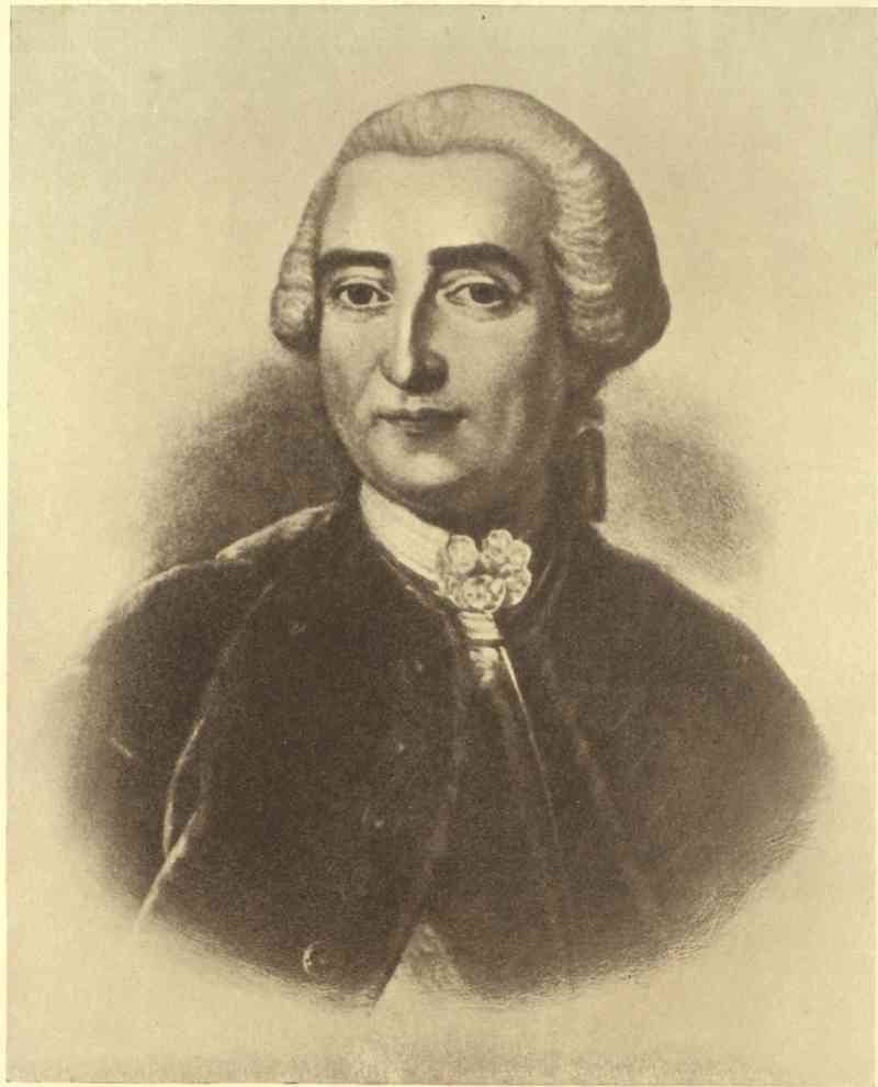
MARQUIS DE MONTCALM
After the original painting owned by the Marquis de Montcalm
At the opening of navigation Vaudreuil received a warning that Holborne was sailing from Cork against Louisbourg and, perhaps, Quebec. Should there be any fear for Quebec all available forces were to be concentrated there. If not, they could be employed offensively, as Louisbourg would be reinforced from France. It soon became evident that Loudoun would never get near Quebec, and so Vaudreuil, in his interfering way, gave Montcalm as little of a free hand as he could to take the field.
That spring there had been an Indian gathering at Montreal the like of which no man had ever seen before. French agents had been active all the winter in the West, where the fame of Montcalm had spread far and wide. The medicine men saw visions of countless British scalps, many of the tribes saw a chance of vengeance against the settlers who had been dispossessing them; and all expected presents from the French and booty from the British. By the end of June Montreal was swarming with braves from Acadia to the Lakes, the Mississippi and beyond. Here, in one throng, were these wildest of wild savages rubbing shoulders with dames and dandies from the most polished court in Europe. Montcalm, of course, was the one man they wished to admire—the great war-chief who had swept the British from a war-path that now stretched unbroken for five moons’ journey, from the Eastern ocean to the Southern sea. They were at first disappointed to find him of only middle height. ‘We thought his head would be lost in the clouds.’ But when he spoke war to them they recognized him as every inch a soldier. ‘Now we see in your eyes the strength of the oak and the swoop of the eagle.’
Early in July Montcalm left for the frontier, where Bourlamaque with two battalions had been strengthening Ticonderoga and watching the British since May. The total French force was nearly 8000, of which barely 3000 were regulars, including 500 colonials, another 3000 were militia, and 2000 were Indians. The British force within supporting distance was about half this. There were 500 men in Fort William Henry under Lieutenant-Colonel Monro, 1700 in the entrenched camp near by, and 1600 with the inert Webb fourteen miles away at Fort Edward. The first brush was disastrous to the 300 men of a British reconnoitring party, who were ambushed by Langlade’s Indians and Canadians far down the lake. Only two boats escaped out of twenty-three. Several barrels of rum were taken with the prisoners, who suffered death by torture in consequence. Another and much smaller party was surprised near the French camp on August 2; several were killed, and three were captured and brought to Montcalm. From them Montcalm found out that Monro had only 500 men in Fort William Henry.
The next morning the French, having brought most of their siege material by water, but a good deal by land over terribly difficult country, pressed round to the investment. The British who were encamped outside had a skirmish with Lévis on their way in, and at the end of it La Corne held the road to Fort Edward with several hundred Indians. Montcalm reconnoitred, saw the fort was too strong to be stormed, and sent in a summons, to which Monro replied that he was ready to defend himself. He expected Webb’s 1600 to come to his relief, and Webb expected reinforcements from the south. Webb was in a critical position. As the Canadians and Indians could not be kept together for any length of time in August, and as he was exposed to defeat in detail with his troops in three parts, he might have blown up Fort William Henry, destroyed the road, and concentrated his 3800 round Fort Edward. But he sat still; and on the night of the 4th sent a messenger with a letter to Monro, telling him not to expect help, but to make the best terms possible.
The next morning Montcalm’s guns opened fire and sent the splinters flying round the ears of the garrison, to the unbounded delight of the Indians, who yelled like fiends. The British replied energetically, and seemed well able to hold their own. But Webb’s messenger was killed on his way in, and Webb’s letter brought to Montcalm, who sent it on to Monro with his compliments. However, Monro still held out, though the odds were increasing against him. His best guns were put out of action, while the French batteries were being strengthened. On the 9th he offered to surrender if Montcalm would grant the honours of war. The Indian chiefs were called into council at the French camp, the terms clearly explained to them, and their promise taken that they would prevent any excess on the part of their followers. This was Montcalm’s first campaign with any large mixed force of the wilder tribes of Indians; and he and his lieutenants thought all reasonable precautions that would not unduly offend the Indians had been taken. An escort of French regulars was told off for the following day; and the British evacuated the fort and concentrated in their entrenched camp ready for an early start.
But that night some of the Indians got into the fort through the embrasures, in spite of the French guard, and massacred the sick. Montcalm immediately rushed down with an armed party, stopped the Indians, and got two chiefs from every tribe to be ready to march off with the prisoners and escort in the morning. He also sent La Corne among them to keep them in hand. The British had an uneasy night and were astir by dawn. Seventeen wounded were tomahawked on the outskirts of the camp before the escort arrived. When the column moved off the Indians crowded in, snatching booty and demanding rum. This, unfortunately, had not been destroyed; the prisoners furthest from the escort were afraid to refuse; the Indians, who had smelt blood already that day, got wild with drink, and a scene of horror immediately began. Montcalm, Lévis, Bourlamaque and other French officers came running down at the news, and fearlessly exposed their lives in stopping the massacre. Altogether, about a hundred were killed, including those in the fort the night before and the wounded in the early morning. Four hundred, whom the Indians carried off, were rescued and sent into Fort Edward under guard. Others who had fled also got in, guided by cannon fired at intervals. Others again were subsequently ransomed by the French and sent home. The greater number arrived safe at Fort Edward under their original escort.
This massacre naturally excited a fury of resentment among the British; and many a case of ‘No Quarter’ was traceable to its memory. It caused the British authorities to cancel the parole requiring the prisoners not to serve again during the war. Some of its victims were avenged by the deadly ravages of the smallpox caught by the Indians in the fort and spread broadcast among their tribes. The facts, of course, were greatly exaggerated by the British; but they were bad enough. It is quite clear that Montcalm and his officers had no hand in instigating what they risked their lives to stop. Montcalm also has the good defence that he had never before had such wild tribes under him, that there had been no gross outrage at Oswego, that he had taken what seemed to him sufficient precautions, and that his duty compelled him to court the Indians, while his position denied him a really effective command. At the worst, he made an error of judgment, for which he was unduly blamed.[1] The Canadians, accustomed to border war, ought to have known better; but many of them ostentatiously disregarded the possibility of an outrage, and some of their wilder spirits egged the Indians on. As for the Indians, they had exactly the manners and customs of the prehistoric age in which the French and British would themselves have acted just as savagely.
|
A close study of that unhappy incident justifies entirely, in our mind, Montcalm’s conduct on that occasion. He did his best to ensure the safety of the English prisoners. (Note of the special editor.) |
Towards the end of 1757 Frederick the Great checked the apparently overwhelming forces against him at Rossbach and Leuthen. In the following summer he beat back the Russians at Zorndorf; and though he lost to the Austrians at Hochkirchen in October he finished the campaign by a triumphant march through Silesia. Acting with restless energy and consummate skill on interior lines he moved rapidly from point to point, preventing his slower enemies, who acted on exterior lines, from combining to crush him. Ferdinand of Brunswick drove the French out of Hanover and defeated them in June at Crefeld. Thus the enemy were everywhere swept back beyond the German frontiers they had so often overrun.
FACSIMILE OF A LETTER CONCERNING A PLAN OF QUEBEC BY PAT. MACKELLAR, ENGINEER-IN-CHIEF AT THE SIEGE OF QUEBEC.
Office of Ordnance, 12th of July 1757.
Right Honble
&
Honble Gentlemen
I take the Liberty to present your Honours with a Plan of Quebeck, and a short Discription, of what (as an Engineer) I thought most worthy of Attention, concerning the Place and the Navagation to it.
The Plan is copied from a printed one of Bellins Published in Charles Voix, which is the best I have seen, I have enlarged it considerably to a scale of English Measure, and have made such additions as I found wanting in the Places I had Access to see.
The Discription is made from my own Observations and what Intelligence I could pick up during the Short Oppertunity I had.
I woud not presume to trouble your Honrs with the Copy of a Printed Plan, unless I thought it more Complete and Expressive than the originall—& which with the Discription, I think gives a clearer representation of the whole, than any thing I have mett with, As such I present them to your Honours and hope they may be Usefull in case of any Attempts that way.
I am with great Respect
Right Honble
&
Honble Gentlemen
Your Honrs
Most Obedient & Most Host Humble Ser.
PAT MACKELLAR
Engr in Ordinary
To The Honble Board
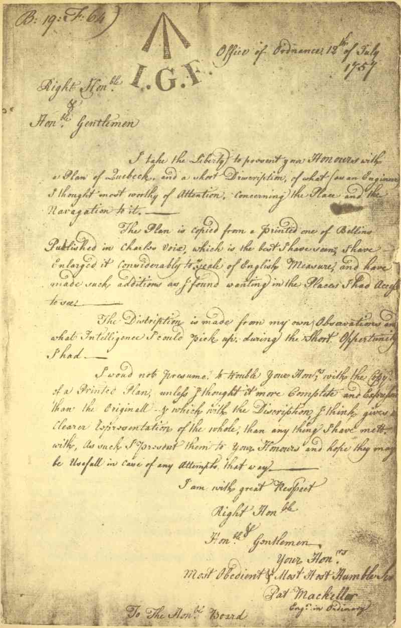
But the greatest influence brought to bear on the world-wide issues in 1758 was Pitt’s accession to settled power. When in office before, during the winter of 1756-57, he had dismissed the foreign mercenaries, increased the militia, raised the Highland regiments, and given the country a glimpse of what imperial statesmanship really ought to be. But it was not until 1758 that he was able to exert a continuous control on the war. His great administration lasted four years, from June 29, 1757, to October 5, 1761. He had his faults: a certain theatricality of manner, a too visible contempt for the common cry of politicians, and a too purely vindictive attitude towards the Bourbons; but as a great war-statesman he was, and remains, unrivalled. History makes much of the bad beginning and worse ending of the Seven Years’ War. But Pitt was out of power on both occasions. The central period is the justification of the whole war, and the glory of the central period is Pitt. He roused the English people to the highest patriotism. He touched the Celts and oversea British as they never had been touched from London before, nor have been since. He understood, as no one in politics before him had, what a British commonwealth of empire ought to be. He knew how to exert amphibious force in every direction and combination where it would be most effective. He knew all the relations between the civil and military resources of the peoples he led to victory, all the importance of sea-power, all the functions of the British army, all the strength of a real united service. And—his crowning virtue as a minister of war—he knew and practised the supreme art of controlling operations everywhere without interfering with them anywhere.
Next to Pitt came Anson, good as a fighting admiral, but better as first lord. When he chose Anson, Pitt ignored those trammels of party which are such stumbling-blocks to the mere politician, and he gloried in it. ‘I replaced Lord Anson at the Admiralty, and I thank God that I had resolution enough to do so.’ Anson made two mistakes: he appointed Byng and failed to foresee that Spain was joining France in 1762. In all else, from desk to dockyard, from selecting the model of a single ship to combining the strategy of battle-fleets over the whole world, he splendidly excelled. He had the principal hand in the headquarters work of the first regular system of blockade, the destruction of the French invasion transports at Havre, the fleet-actions at Lagos and Quiberon, and the capture of Louisbourg, Quebec, Montreal, Martinique, Manila and Havana. Even more important was his remarkable faculty for bringing the best executive men to the front; among them seven first-rate admirals—Hawke, Boscawen, Osborn, Saunders, Rodney, Howe and Keppel. Two other famous sea-fighters also owed him their first commissions, the Earls of St Vincent and Camperdown.
The army could count on no such handling as this—and indeed its need was less, for its opportunities were more restricted. But Ligonier was a capable commander-in-chief, and George II knew what soldiering means in peace and war.
Pitt could not change the whole face of the war at once; but he confirmed his policy of subsidizing Frederick for the great campaigns on land, while he devoted the British army and navy to united-service work designed to distract Frederick’s enemies in Europe and ensure British imperial expansion overseas. The merchant navy was fast increasing British prosperity, as the mercantile community gratefully acknowledged later on; while the fighting navy, to which it owed its security, was fast destroying its rival, capturing all that was left of the French merchantmen, and 176 neutrals with French cargoes. Pocock was fighting d’Aché in the East, where Clive had turned the tide of war the previous year at Plassey, and d’Aché, though he held his own in battle, crawled home exhausted, because British sea-power had made the sea a desert to all its enemies. Senegal and Goree fell in Africa; Cherbourg in France itself. Even Russia and Austria began to feel the weight of hostile British sea-power. And meantime the navy that was doing all this in the Old World was also destroying the forces that might have aided the French cause in the New. A French fleet was shut up in Cartagena before the year began. Duquesne went to help it out, but lost his own squadron instead. And du Chaffault, who reached Isle Royale, had to go on to Quebec to keep his fleet in being. In France the pressure of British sea-power was beginning to tell on every department of life, while in Canada it was already beginning to exert that constricting death-grip which it never relaxed till the whole colony surrendered at Montreal.
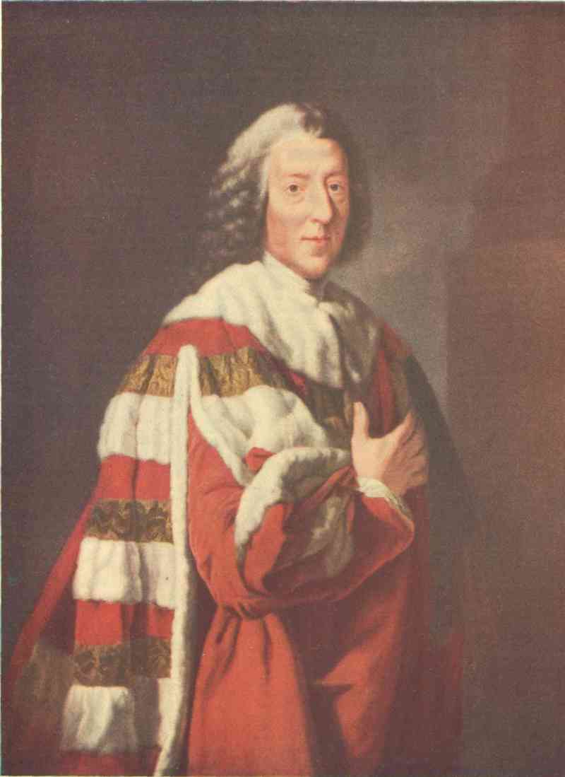
Emery Walker Ltd. photo & imp.
WILLIAM PITT, EARL OF CHATHAM
From a painting in the National Portrait Gallery
Bigot belongs more to the general history of Canada than to that of the Seven Years’ War. But it must be remembered that when he was preying on her vital resources he was weakening her, in a military sense, quite as much from the inside as the British navy was from without. Of course he had accomplices, and the whole vampire brood together flocked round the prey more greedily than ever when they saw that a British conquest might take it out of their clutches. As this disaster grew more and more imminent, at a time when even the lax French government was beginning to watch them, they mostly welcomed the catastrophe, in the hope that individual misdeeds might be covered up in universal ruin. Vaudreuil was not among these chartered brigands, but he condoned them. He approved scandalous contracts for the commissariat and transport, for useless fire-ships, bad ammunition and worse forts; and he was the official commander-in-chief. There stand his acts and words against him, to damn him for ever at the bar of history. Very different were Montcalm, his lieutenants, and nearly all his officers and men, as well as the Canadian habitants and priests. The sword and cross led well, through those last dire years, and the people followed faithfully, according to their lights and in spite of the paralysing misery of their condition. But in Canada everything which, under self-government, would be called ‘politics’ and civil service was rotten to the core.
The British plan of campaign was the old one of simultaneous attacks on the French flanks and centre. Louisbourg and Fort Duquesne were to be destroyed, while the centre was to be driven in along the line of Lake Champlain.
Montcalm’s advice was to concentrate at Ticonderoga. But Vaudreuil insisted on sending his brother with Lévis to make a useless ‘diversion’ towards Oswego. The French were weak enough as it was. Provisions and transport were both so scarce that the regulars had to be widely scattered among the habitants for the winter, and fed on half-rations of horse-flesh. The generals ate the same fare; but Bigot and his myrmidons lived in luxury on the best of the food intended for the colony. The regulars, underfed as they were and necessarily slackened in drill and discipline by their long stay in scattered winter quarters, yet once more answered the call to arms as readily as ever. The militia were not available, partly because some of them had gone on Vaudreuil’s wild-goose chase towards Oswego; partly because others took the alternative of exemption, on condition of carrying Bigot’s goods about the country free; partly because some had to remain at home if there was to be any harvest, and partly because Vaudreuil, in order that he might keep the soldiers under his own orders as long as possible, would not let Montcalm have those who really were available. Thus Ticonderoga, to Vaudreuil’s subsequent disgust, became a victory won mainly by the French regulars. To complete his spiteful interference Vaudreuil issued such ambiguous orders that Montcalm found himself deprived of all initiative while charged with all the responsibility—especially in case of failure. A personal interview followed, and Vaudreuil, frightened by his own ineptitude, signed new orders drafted by Montcalm himself. Much time was lost by all these vexatious delays, and it was only on June 24, within a fortnight of the battle, that Montcalm could leave Montreal for the front. On the 30th he entered Ticonderoga, where he found his eight battalions reduced to 2970 men, owing to the many good men who had been sent off towards Oswego, and the many bad recruits he had been obliged to leave behind. Provisions and fortifications were in still worse condition. The intendance and civil contractors were responsible for both.
Yet Ticonderoga was an excellent position, and Montcalm made the most of it. It stood on a small peninsula, commanding the only open waters to the north, and the nature of the surrounding country was such that no army could advance by any other route. The peninsula projected about three-quarters of a mile, and its neck was about the same distance across. The fort, not too well gunned, was garrisoned by one battalion. The remaining seven were entrenched across the left half of the neck, which was high ground, with the flanks curved back at right angles to the front. The right flank ran back to within 600 yards of the fort, and the two were connected by the straight line of the height of ground which ran from this flank to the fort. The right was further protected by having a clear line of fire cut through the woods to the right of the fort, and by an entrenchment protecting the right rear of the main position. The British were so many and the French so few that the situation seemed desperate. But a week’s incessant hard work wrought a wonderful change. The officers used axe and rope to encourage the men. A continuous abattis of trees, with their sharpened branches pointing outwards, ran completely round the thousand yards of entrenchment manned by 3000 French regulars. Including the 451 Canadian regulars and militia, and the 200 more who joined during the action, with the garrison of the fort, Montcalm had barely 4000 men all told, from first to last. The gallant Lévis joined only the night before the battle, which he nearly missed altogether, owing to the absurd ‘diversion’ against Oswego, on which Vaudreuil had thrown him away.
Meanwhile Abercromby was advancing with four times as many men. On the morning of the 5th, a calm and cloudless day, more than a thousand boats began their journey up beautiful Lake George, just as the sun rose above the forest-clad hills. Never had such pageantry of war appeared in all America. In the centre 6000 regulars, resplendent in scarlet and white and gold, on the flanks 9000 provincials in dense clusters of blue, and in rear bateaux and double flatboats, platformed for the artillery and train. Thousands of oars gleamed in the sunlight, the very air was vibrant with music, the rolling drums woke every echo, and, piercing the other sounds, the pipes of the Black Watch screamed Highland defiance at the foe.
Abercromby had learnt nothing since coming to America. But the young second-in-command, Lord Howe, was both the head and heart of the whole army. Wolfe called him the noblest of Englishmen and the best soldier in the army, and Pitt himself said he was a complete model of the military virtues. Unluckily for the British, he fell in the first preliminary skirmish. Abercromby had now to think for himself. He sent out an engineer, who foolishly reported that the abattis could be taken by assault. He then advanced his infantry and left his artillery behind. He tried one diversion, by some boats, against the French left, but the guns of the fort and the nearest French infantry, who immediately lined the shore, soon drove back this party.
In the great attack there were 14,000 against 4000; but of these only the regulars came to close quarters, 6000 against 3000. The 8000 provincials lined the edge of the clearing which Montcalm had made, two hundred yards wide, all round his position. The four assaulting columns of redcoats were formed up just after noon, a single gun fired from the fort gave the signal for the French to drop their tools—they were working till the last minute—and take up their muskets: and the battle began. The first rush looked as if it must carry all before it. But the heads of the columns got entangled in the abattis, and were mown down by point-blank musketry from the entrenchments, where Montcalm had one man for every foot of frontage. Again and again the attack was renewed; again and again it surged back, like the waves of a stormy ebb, angrily leaving the wreckage on the shore. All that hot, still, midsummer afternoon the British columns beat in vain against Montcalm’s magnificent defence. During a lull in the firing some of his men, who knew why Vaudreuil had withheld the reinforcements, were overheard saying, ‘The governor has sold the colony, but we won’t let him deliver it.’ At last Abercromby, who never came near the firing-line, ordered a final effort. It was as gallantly made and met as the others. He then drew off, went back to his boats, and was soon completely out of touch with his victorious enemy. The British loss was nearly 2000. The regulars lost twenty-seven per cent of their own numbers, the provincials only four.
Vaudreuil sent reinforcements when their usefulness was gone, wrote new ambiguous orders, and began to claim the victory for the militia. As they numbered only 450 at the beginning of the battle and only 200 more at the end, and as their loss was only four per cent compared with the French twelve, it is manifestly absurd to suppose that this one-seventh of Montcalm’s army had any claims to distinction comparable to those of the other six-sevenths. The total French loss was exactly 400, only one-fifth as much as the British.
Montcalm had been again victorious. But he was sick at heart. ‘What a country,’ he wrote home, ‘where rogues grow rich and honest men are ruined.’ His emoluments were insufficient from the first. Now that corruption and hostile sea-power had sent prices up tenfold, he saw himself getting hopelessly into debt, along with every other honest officer around him. The reward that he and they would have liked best of all would have been their recall to France. He did, indeed, write for his. But he soon heard news of disaster elsewhere, which made him volunteer to stay at his post till the end.
Louisbourg was garrisoned by about 3000 effective troops under the Chevalier Drucour, a brave and capable commander, who had been much harassed by the difficulties of his position since the war began. There were also some armed inhabitants and a band of useless Indians. But in the harbour lay twelve men-of-war with crews amounting to another 3000. The fortress was strong enough in itself; but it was commanded by a hillock only half a mile away inland, while the fleet in the harbour was at the mercy of any batteries that could be erected on the surrounding heights. The British landing was a fine bit of work, chiefly due to Wolfe, who, though the junior brigadier present, was the dominant hero of the siege. Amherst had 12,000 men, twice Drucour’s total effectives, while Boscawen’s forty-one men-of-war had four times the force of the French squadron in the harbour. The result was a foregone conclusion. The walls were breached; the French ships destroyed. The British united service was making its first great effort under Pitt’s own control, and making it well. Not that the fighting was heavy, as the loss on both sides together amounted to only five per cent of the totals engaged afloat and ashore. But the taking of Louisbourg was of the first importance to clear the way to Quebec, to turn the tide of war in America, and to re-establish lost prestige in the eyes of the colonies and the world at large. Drucour’s only hope was to hold out long enough to save Quebec from attack; and he attained it, by not surrendering until July 26, though the British expedition had appeared at the beginning of June.
The next month another British success occurred, when Bradstreet, without losing one man, took Fort Frontenac (now Kingston) and all its stores, with the whole of the nine French vessels on Lake Ontario. At the end of the year the indefatigable Brigadier John Forbes, so ill that he had to be carried on a litter, marched into the famous Fort Duquesne, which the French had abandoned and blown up, and dated his dispatch from ‘Pittsbourgh.’
Thus 1758 closed in the deepest gloom for French Canada, which had now shrunk back into a line of little half-starved settlements along the St Lawrence, with outposts on Lake Champlain, and one great natural stronghold at Quebec.
Glorious as the year 1759 proved to be for the British cause, it began badly abroad, witnessed a wild panic at home, was of doubtful issue in Canada until the autumn, and closed without re-establishing British military prestige on European battlefields. The French made a great effort, took Frankfort in January, and defeated Ferdinand of Brunswick at Bergen in April. Frederick attacked double his numbers of Austrians and Russians at Kunersdorf in August, when he suffered a terrible and exhausting defeat, which more than offset Ferdinand’s incomplete victory over the French at Minden, where the British infantry did so magnificently well and the British cavalry so disgracefully ill.
But what the British public felt most was the fear of the great invasion which the French, stung to the quick by British naval supremacy all over the world, were determined to attempt against the heart of the Empire. Choiseul was active and able, and his plans well laid. The malcontents in Ireland and the military weakness in Scotland were to make the invasions of these two countries feasible with comparatively small forces. Fifty thousand of the best French troops were to strike at England direct. Transports were collected at Dunkirk, Havre, Brest and Rochefort. The Brest and Toulon squadrons were to unite at the Morbihan and convoy the army for Ireland. Five frigates were to convoy the smaller army for Scotland. The main body, convoyed by every ship available, was to make a dash for the south of England in flat-bottomed boats from Havre. Naturally enough, the public soon caught the invasion scare. But Pitt, Anson, Ligonier, the king, and the few other real leaders of the time, all knew better. Three years before, a ministry of mediocrities were for hiring Hanoverians to defend England on shore against a French invasion. But now Pitt carried his colleagues with him in planning and executing a scheme for defending both England and the Empire by a well co-ordinated system of fighting blockade and oversea attack. He was of the same opinion that Pericles had expressed at Athens two thousand years before: ‘If the enemy are kept off the sea by our superior force, their want of practice will make them unskilful, and their want of skill will make them timid.’ Of course there was a concurrent plan of pure defence; but it was subsidiary; and the home-defence forces were always held in readiness to strengthen the attacking line abroad. The main objective was the French army of invasion. But, instead of waiting to fight it on land at home, Pitt used the navy to destroy its means of ever crossing the sea. Havre, Brest and Toulon were watched by Rodney, Hawke and Boscawen. Flying squadrons cruised off Dunkirk and the Morbihan; and a reserve fleet was held ready in the Downs. The wisdom of this course was apparent only to the few at first; the mass of any scared public is always mob-minded enough to prefer forts and soldiers which it can see to ships and sailors which it can not. But, fortunately for the British Empire at this great crisis in its history, the public did have sufficient confidence in Pitt to let him act like the supreme war-statesman that he was.
Nothing shows Pitt’s consummate genius better than the fact that he sent a quarter of the whole navy against Quebec, although a great French army was then preparing to strike at London. He thoroughly grasped the basic principle that as all the seas in the world are one, so the sea-power that commands them must also be one; and, grasping this, he applied it—east and west and centre—with perfect consistency, to the whole world-wide theatre of war. He stood like a battlefield commander whose right was in America, whose left was in Asia, whose front was in France, and whose base was England. With this whole field continually before him, he told off the right flank of his united service to effect the conquest of Canada.
But Pitt was more than even a world-strategist. He was the heart as well as the head of the war. The British Colonies in America responded at once to the sympathetic insight with which he handled them. It was an unwonted touch which came from London, and it put them on their mettle. He gave their officers relative rank up to colonel; and they became companions in arms with the British regulars. He promised them munitions of war and suitable reimbursements; and New England, New York and New Jersey raised their twenty thousand men, while Pennsylvania and the South recruited others to attack the West. Massachusetts and Connecticut raised their real estate war tax to the enormous height of thirty-six per cent, though they also had a personal tax of nineteen shillings on every male over sixteen. Of course there were other motives: hatred and revenge in many instances; and a very strong feeling among the puritans that they were doing battle against the powers of darkness and papistry together. Their preachers never failed to beat the ‘drum ecclesiastick’ at every opportunity, with quite as much vigour as ever it was beaten by the catholic priests across the border. Then, it was felt that the campaign of 1759 was something like a long-deferred fulfilment of the ‘Glorious Enterprise’ of conquering New France, which Peter Schuyler of Albany had formulated as early as seventy years before. But all these were only tributary streams to the great current of popular enthusiasm which had been roused by the feeling that the hour and the man had at last come together at headquarters.
The local objectives were three, as usual. The French right was to be finally cut off from the West by the capture of its last remaining link at Niagara. The centre was once more to be driven in along the line of Lake Champlain. But, as the French left had already been uncovered by the fall of Louisbourg, the attack against it was to be pressed home to Quebec, which, being the greatest stronghold and point of connection with France, was really more central and far more important than Montreal, Three Rivers, or any other position that could be reached by the line of Lake Champlain. The plan also provided for concerted action and eventual junction between the British right and centre, according to the developments of the campaign. If the centre got through, it was to combine with the right. If the right took Quebec early enough, or the enemy retired, it was to combine with the centre. The object in either case was to crush Montcalm between them.
The French plan was simply to maintain an effective foothold, if possible, at Quebec. Should Quebec itself fall the army might retire to safety till the next year, when the war might take a favourable turn elsewhere, or peace might supervene. In this case the actual possession of a strategic point, preferably Quebec, would be of the last importance. France certainly had no intention of abandoning Canada; but how could she reinforce her colony in face of the ubiquitous British fleet? Besides, if the invasion of England should succeed, the fate of Canada could be settled in Europe. So Montcalm concentrated at Quebec, with his outposts at Niagara and Ticonderoga, and prepared to do his best with the very imperfect means at his disposal.
The total French effectives did not exceed 20,000. The best troops, the French regulars, were under 4000; the Canadian regulars were 1500; the militia was about 13,000; there were a few hundred coureurs de bois along the Lakes and in Acadia, say 500; and about 1000 Indians remained faithful. Some deduction should be made for the average of sick and for other ineffectives. But this would be offset by the seamen of the few men-of-war and transports. Against this mixed force of 20,000 the British could bring about 40,000. There were 5000 men told off against Niagara, 11,000 against Crown Point, and 9000—with a fleet manned by about 14,000—against Quebec. Some small parties and Johnson’s Indians made up the total. Brigadier Stanwix, who was to safeguard Pittsburg from Indian raids, may be left out on the British side, and his opponents on the French.
Late in June Brigadier Prideaux and Major-General Johnson arrived at the ruins of Oswego. Leaving Haldimand here to secure their communications, they crossed Lake Ontario, vainly summoned Pouchot to surrender, and opened their first parallel at 600 yards. Ten days later, after vexatious muddling on the part of the incompetent engineers, the attack was being pressed, when the premature explosion of a shell killed Prideaux on the spot. Johnson succeeded him, and, five days later, on July 24, had to repel a determined effort by troops from Presqu’ Isle to raise the siege. The French reinforcements attacked the British with the utmost bravery, and lost every officer except three. But they and their Indians finally broke and made for their canoes. They subsequently destroyed the forts at Presqu’ Isle, Le Bœuf and Venango, and retired to Detroit. After this, Pouchot had no choice left, and surrendered on July 25, with his little garrison of less than 500 men, who were sent to New York as prisoners of war. There was then no combatant body of Frenchmen left in the whole Ohio region. Their last link with the West was broken.
Two days before Pouchot surrendered Niagara more than 2000 men under Bourlamaque slipped out of Ticonderoga, before which Amherst was appearing at the head of 11,000, nearly half of whom were provincial militia. The French left behind 400 men, who defended themselves vigorously against the overwhelming British force. On the night of July 26 three deserters arrived with the news that the garrison was stealing away, and had left a slow match burning towards the magazine. Amherst vainly offered a hundred guineas to any one of them who would point it out. At midnight a gigantic geyser of flame shot skyward with an explosion which lifted one entire bastion into the air. The white and gold of the fleur-de-lis stood out against the lurid background, still waving defiantly. A British sergeant ran through the flames, braving the powder and shells which were blowing up on every side, and hauled it down. This was the last fleur-de-lis to fly over the lake which Champlain had discovered exactly a century and a half before, and which the long fight for its possession has made so famous in Canadian history.
On August 1 Amherst learnt that Bourlamaque had also blown up Crown Point. Except for two obstacles the way was now open for an attack on Isle-aux-Noix, at the north of Lake Champlain, where Bourlamaque had been ordered to defend himself to the last extremity. The first was the little French flotilla of four vessels, carrying thirty-four guns, which Vaudreuil, foreseeing this eventuality, had wisely built some time before. The second was Amherst himself, who, though a good soldier, was over-cautious and meticulously slow. He looked on the most open campaign as a sort of siege, and he approached a distant enemy in the field as if by sap and parallel. However, he is not to blame for building a little navy of his own, because the country was impassable by any force in face of an enemy that had command of the lake. But some one—perhaps he or the colonial authorities, or even Pitt—is certainly to blame for not having foreseen this difficulty and provided against it. The work went slowly, owing to a lamentable lack of plant; and it was late in the autumn before a naval supremacy was obtained. A cutting-out expedition might have been tried, long before, failing other means. But Amherst was not the man to cut out the smallest fleet with mere boats. He crept along with his 11,000 men, held Bourlamaque at Isle-aux-Noix, caused Montcalm to detach Lévis with a few good troops from Quebec, and made his own path smoother for the next year. But he might not have required it then had he been more dashing this year and more far-sighted the year before.
There was only one brilliant bit of work done; and that was done by provincial rangers out of sight of Amherst. Major Robert Rogers, the famous fighting scout, was sent from Crown Point to punish the Abnakis on the St Francis River near its junction with the St Lawrence. The day Wolfe and Montcalm met on the Plains of Abraham, Rogers sailed for Missisquoi Bay with 200 men. There he hid his boats and started through the bush. The second day out an Indian overtook him to say a stronger force of French was on his trail. A lesser man would have lost his objective and perhaps his own command too; but Rogers immediately quickened his pace, outmarched his pursuers, destroyed the Indian settlement, killing more than his own men numbered altogether, and returned by another way, after incredible privations. His triumph would have been complete had the relief party, which he asked Amherst by courier to send to meet him by this unexpected way, only kept its rendezvous. But this was not his fault. He succeeded alone. And his raid stands out as the one vivid feature of the dull Amherstian campaign.
For eight long, weary months not a single word passed the sea between Old France and New. Every one in the colony felt that the crisis of its whole life was at hand. Bigot and his peculating followers hastened to get rich quickly before the crash came. As the wealth of Canada sank the amounts of the government contracts rose. In 1757 they doubled; in 1758 they trebled. Famine prices ruled the market, and not an honest man could pay them, so impossible was it to make money honestly by competing against Bigot’s men in trade, or for officers to live on their pay. The miserable habitants never once had even half-rations all the winter. Vaudreuil threatened to imprison those who complained; but Montcalm befriended them to the utmost of his little power. He lived on horse-flesh, four ounces a day, like his officers and men. But the intendant’s palace was always full of gluttony, gambling and flaunting debauchery.
In the autumn Vaudreuil had agreed that an immediate appeal to France should be sent by the hands of two men whom both he and Montcalm could trust. Two good men were chosen, Doreil, the ‘commissary of war,’ and Bougainville, an exceedingly able young colonel, whose scientific attainments had ensured his election as a fellow of the Royal Society in England, who subsequently distinguished himself as a naval officer and great explorer, and who lived to see Napoleon at the zenith of imperial glory. Vaudreuil officially recommended Doreil: ‘I have full confidence in him,’ he wrote; and of Bougainville: ‘He is in all respects better fitted than any one else to inform you of the state of the colony. You can trust entirely to what he tells you.’ But, by the very same ship, he sent a secret letter saying, ‘I have given letters to MM. Doreil and Bougainville, but I have the honour to inform you that they do not understand the colony, and to warn you that they are creatures of M. de Montcalm.’ This, of course, was no isolated stab in the dark. Vaudreuil, with Bigot and his associates, had taken good care for some time past that the minds of the home authorities should be poisoned against Montcalm and his army as much as possible.
The mission was foredoomed to failure so far as great reinforcements were concerned, because the sea was closed to them. More might have been done if the increasingly bitter experience of the last few years had not taught the French government that no amount of supplies could keep Canada from the verge of ruin. On May 10 Bougainville arrived in Quebec. By the 20th there were twenty-three sail in the harbour. They got through just in time; for three days later the beacon-fires announced the arrival of the vanguard of the British fleet at Bic, 170 miles down the river. ‘A little is precious to those who have nothing,’ said Montcalm. There were 326 recruits for his eight battalions, and Quebec was provisioned for a siege, that is, if it could keep communications open up the river, whence the only food-stuffs raised in the country would come when the British fleet had sealed the St Lawrence below. Little enough, indeed, would have come from the country below in any case, as Wolfe had been sent with Admiral Hardy to waste the farms and fishing-places along the gulf shortly after the surrender of Louisbourg.
Bougainville had brought out instructions, promotions and decorations in profusion. Montcalm was made a lieutenant-general and decorated for his victory at Ticonderoga. At a bound he had become famous all over France, even in the stress of that great European war. The little children in the streets all knew his name as the champion of France against the English. But there was sad news, too. One of his daughters had died, and Bougainville had sailed before hearing which. ‘It must be poor Mirète,’ wrote Montcalm. ‘I love her so much.’ To his wife he wrote: ‘Can we hope for another miracle to save us? . . . We have had no news for the last eight months, and who knows if any more can reach us again this year.’ He never did hear from home again. The instructions he received from Marshal Belle-Isle were, in fact, his death-warrant: ‘However small the space you can retain may be, you must, positively, keep some foothold in America. . . . I have answered for you to the king.’ In his reply Montcalm said: ‘I shall do everything to save this unhappy colony or die.’ And he kept his word.
Meanwhile Pitt was busy at the British headquarters. On December 29 he wrote secret instructions to Durell and Amherst, the naval and military commanders in America. In January 1759 he wrote to them again, and three times to Saunders, the naval commander-in-chief against Quebec.
On February 5 he gave Wolfe his secret orders. All the commanders, afloat and ashore, were put into confidential touch with each other. Transports were collected and prepared on both sides of the Atlantic, and on February 16 Saunders and Wolfe sailed from Spithead for the general rendezvous at Louisbourg. The winter had been very severe—Durell had several men frozen to death—and there was so much ice off Cape Breton that the course was shaped for Halifax, which was reached only on April 30. Louisbourg was reached on May 15, and twenty very busy days were spent in final preparations.
Saunders had a great reputation in the service, but was little known outside. He had been Anson’s first lieutenant on the famous voyage round the world. He had distinguished himself in action as a captain under Hawke, with whom he went out, nine years later, as part of the ‘cargo of courage’ sent to retrieve the situation in the Mediterranean after Byng’s disgrace; and he closed his career by being one of the most efficient first lords who ever ruled the Admiralty. He was in the direct line of the greatest naval tradition, Anson being his patron, and he himself being a patron of Jervis, who was a patron of Nelson. His fleet comprised a full quarter of the whole royal navy, and 1759 was a year in which the naval estimates reached an unprecedented height. His total personnel would have been quite 15,000 had some of his ships not been short-handed. Some excellent colonial seamen were recruited at Boston for the campaign, but they did not suffice to complete the ship’s companies, which numbered barely 14,000 all told. There were 49 men-of-war, carrying nearly 2000 pieces of ordnance, and making the most formidable single fleet which had ever sailed the sea up to that time. The transports were, of course, under the admiral’s control, and their crews brought the total number of seamen up to over 18,000. Thus there were twice as many seamen as landsmen engaged in the siege of Quebec.
Wolfe’s little army of 9000 men was the highly efficient landing party from this mighty fleet, which was now about to play its part in the world-wide strategy of the ‘Maritime War.’ Wolfe, now thirty-two, had had a long and distinguished career for his age. Like nearly all our great commanders he belonged to a good family of comparatively small means. His father served under Marlborough, and he began his own service under his father at thirteen. At sixteen he was acting as adjutant to a battalion on active service. He fought at Dettingen, Culloden and Laffeldt; and at twenty-four became commanding officer of the 20th Foot. Two years later, in 1753, he visited Paris, where he had a conversation with the king from whom he was to wrest New France, and with the Pompadour, whose personal charms impressed him very strongly. He was extremely anxious to study the best army in Europe by spending some time in Prussia. But the wiseacres at the War Office refused him leave to do so. During the eight years of peace he trained his men to such a state of efficiency that they became the ‘show regiment’ of the army whenever any distinguished personage was to see the British infantry at its best. He was a marked man even before the Rochefort fiasco in 1757, and his restless energy and professional skill at Louisbourg decided Pitt to select him, junior as he was, for the highly responsible task of reducing Quebec. Some senior dullards called him mad. ‘Then I wish he’d bite my other generals,’ said the king. But though sane in genius Wolfe was sickly in body. He suffered so much from rheumatism and gravel that he only faced life with a gallant despair, knowing his time was short in any case. In person he was very tall, thin, rather awkward, with reddish hair and protruding nose and mouth—not unlike the younger Pitt, and equally open to caricature. But no one took liberties with him. Officers who were slack in their work naturally resented his masterful zeal; but those who were really keen about their profession admired him immensely, and he was very popular with the men. His army was by far the best the New World had yet seen. It was under strength—there were to have been 12,000 instead of 9000—and it was stinted in money and equipment. But it was homogeneous, nine-tenths of it being excellent regulars; and the men had already been seasoned to American conditions by the Louisbourg campaign. It was also exceptionally well officered, and the three brigadiers, Monckton, Townshend and Murray, all sons of peers, were chosen on their merits. Townshend—cold, critical and cursed by enjoying too much political favour—was the only unsympathetic element.
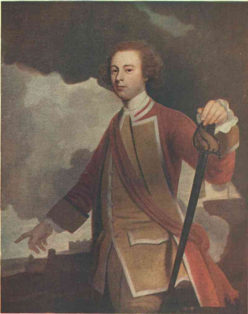
Emery Walker Ltd. photo & imp.
JAMES WOLFE
From a painting in the National Portrait Gallery
The great point, however, is that the fleet and army, with their total of 27,000 men, worked well together, and so formed a splendid single force of the truly British united-service type. This by no means reduced the individual value of either branch, but greatly enhanced both. Neither fleet nor army could have taken Quebec alone. But proper combination halved their difficulties, doubled their strength, and made Wolfe victorious.
On May 5 Durell left Halifax to block the St Lawrence. He was too late, as Bougainville and the twenty-three French transports had just passed in towards Quebec. Durell had spent a hard winter on the station, and his ships were none of the best. But he was rather like Amherst, always slow and not always sure. On the 25th he arrived at Isle-aux-Coudres, sixty miles below Quebec, and sent some vessels ahead to clear the way through the Traverse, a narrow passage thirty miles below Quebec. Montcalm had wished to fortify this, but Vaudreuil overruled him, and the result was that, after a short bombardment, the feeble French batteries were silenced, and the celebrated Captain Cook—then a ‘master’ or navigating officer—sounded the Traverse from end to end. Colonel Guy Carleton was in command of the troops with Durell and landed on Isle-aux-Coudres, which was an excellent strategic position, and which Wolfe thought of as a good place to entrench himself for the winter, if he failed and was not recalled. Montcalm, for his part, had thought that, as a last alternative, he might, if beaten from Quebec, elude pursuit, strike west to the Lakes and then south to the swamps of Louisiana, there to ‘keep a foothold in America’ as long as he could.
On June 4 141 sail weighed anchor at Louisbourg with Saunders and Wolfe. All ranks were in the highest spirits, knowing that they were the picked force chosen for the decisive work of a great campaign, and believing that, led by men with ‘the eye of a Hawke and the heart of a Wolfe,’ they would soon plant ‘British colours on every French fort in America.’ On the 6th the last vessel cleared the harbour, and the voyage to Quebec began. This was one of the greatest feats of navigation ever performed by any fleet under any circumstances. Safe enough when there are plenty of aids to navigation, the St Lawrence was anything but easy for a fleet that had only poor French charts, worse French pilots, and no other outside aids at all. The pilots were generally worse than useless, and the fleet was navigated by its own officers, with consummate skill, through practically unknown waters and without one wreck. The French were dumb-founded when they saw that mighty armada sail with perfect impunity through the redoubtable Traverse, where they would only risk a single vessel of their own with much misgiving. When Vaudreuil and Bigot were on their trial they called the whole colony to witness that the Traverse had always been universally accepted as a natural obstacle impassable by any fleet in the world. What made this exploit all the greater was the fact that the ships—like British vessels generally, throughout the whole of the Great Imperial War—were decidedly inferior in material and design to those of the French and sometimes even to the Spanish. Nelson’s captains always competed for the command of foreign prizes. It was the men, not the ships, that won the British command of the sea.
FACSIMILE OF WOLFE’S WILL
Neptune at Sea, 8th June 1759.
I desire that Miss Lowther’s Picture may be set in Jewels to the amount of five Hundred Guineas, and return’d to her.
I leave to Col. Oughton, Col. Carleton, Col. Howe, & Col. Warde a thousand Pounds each.
I desire Admiral Saunders to accept of my light service of Plate, in remembrance of his Guest.
My Camp Equipage, Kitchen Furniture, Table Linnen, Wine & provisions, I leave to the Officer who succeeds me in the Command.
All my Books & Papers both here & in England, I leave to Col. Carleton.
I leave Major Barre, Capt Delaune, Capt Smyth, Capt Bell, Capt Lesslie & Capt Calwall each a hundred Guineas, to buy swords, & rings in remembrance of their Friend.
My Servant Francois shall have one half of my Cloaths & Linnen here, and the three Foot-men shall divide the rest amongst them.
All the Servants shall be paid their year’s Wages, and their board Wages till they arrive in England, or till they engage with other Masters, or enter into some other profession. Besides this, I leave fifty Guineas to Francois, twenty to Ambrose, and ten to each of the others.
Every thing over and above these Legacies, I leave to my good mother, entirely at her Disposal.
JAM: WOLFE.
Witnesses—
Will DeLaune
Tho Belle
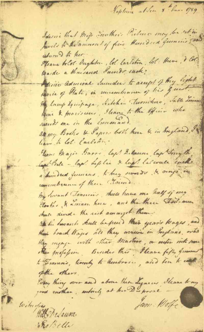
On June 23 Durell’s squadron off Isle-aux-Coudres heard guns to the east just before dawn, and immediately cleared their decks for action. No one knew at first what the new fleet was; for there were two naval possibilities that might have let an enemy appear instead of a friend. The conclusive British command of the sea had not yet been won in Europe, where the French fleets were still in being, and Bompart was known to have passed the winter in the West Indies with a strong squadron. There was little to fear from Europe. But Bompart might have raided the base after Saunders had sailed, extremely difficult as this would have been without a friendly port, or might even have cut in between Saunders and Durell. In either case, if he had fought to the last, his destruction might have meant enough loss on the British side to have made the capture of Quebec impossible for that campaign. As a matter of fact, Bompart limped home with fever-stricken crews, and had the best of his squadron merged with that of Conflans, whose defeat by Hawke at Quiberon in November settled the fate of Quebec in quite the other way.
On June 26 Saunders and Wolfe arrived at the Island of Orleans. Here the twenty days’ voyage ended, and the twelve weeks’ siege began.
An excellent British amphibious force of 27,000 now faced a heterogeneous French army of 17,000. But the many qualifying circumstances made the task before Saunders and Wolfe extremely complex and difficult. Montcalm’s 17,000 were a collection of all sorts, good, bad and indifferent. About 10,000 were militia, that is, the whole male population supposedly fit to bear arms. In addition to the usual drawbacks of such forces, these poor people were naturally beginning to be lukewarm towards the civil government which robbed them right and left. But they could not help admiring the brave, honest and capable military commanders under Montcalm, and some of their own officers, who were also honest. On the whole they answered the call to arms very well indeed, partly owing to the exhortations of their good bishop, Henri de Pontbriand, who had fearlessly denounced the political parasites the winter before. Half the remaining 7000 were French regulars, all sound soldiers, except the half battalion of Languedoc which had been picked up anyhow and sent out to replace the men taken by Boscawen in the gulf before the declaration of war. The troupes de la marine, or French-Canadian regular soldiers, and the naval and mercantile seamen together, each numbered between 1000 and 1500, and several hundred Indians completed the total. Most of the officers of the French-Canadian regulars had become tainted with the prevailing corruption, especially those connected with the supply work of the posts and settlements. The naval seamen were only trained as gunners, and the mercantile seamen were not trained at all. The ships either did transport duty or were sent up the river out of harm’s way. When the British fleet was nearing Quebec a council decided to sink eight in the Traverse, which Montcalm had long wished to have put in a state of defence. But it was then too late. The Indians were less numerous and reliable than before, as the British command of the sea prevented the French from getting the usual supplies for trade and presents. The whole force had been underfed for a year, and the best part of it was to be overworked during the siege; and it suffered, as usual, from being divided into five semi-independent services, all legally under the supreme command of Vaudreuil, whenever that fussy pettifogger chose to interfere with Montcalm, who technically commanded only the French regulars and who was only the ‘adviser’ to whom Vaudreuil was told to ‘defer’ on general military affairs.
But nature had made Quebec almost impregnable by land and immensely strong even if attacked by both land and water. It stands on the eastern extremity of a high, narrow promontory between the St Lawrence and the valley of the St Charles. The St Lawrence is only one thousand yards across opposite the city; it has an eighteen-foot spring tide, with a down current fourteen hours out of the twenty-four running to as much as five knots. The prevailing summer wind blows down stream. Both banks are over three hundred feet high and favourable for defence by artillery. Consequently no fleet, certainly not one with a huge convoy, could safely run up between them. Below Quebec was the only comparatively open ground, running seven miles, from the mouth of the St Charles to the mouth of the Montmorency. But Montcalm had entrenched it all, defended it with floating batteries, and occupied it with his whole force, except the two thousand men in Quebec itself. As Wolfe’s eye swept the French position he saw every point of vantage on the north shore amply defended by nature and man.
Some troops were landed on the south shore below the ‘Point of Levy’ and had a little brush with the enemy. But most were landed on the west end of the Island of Orleans, where the hospital and stores were permanently established. The landing was no sooner effected, on the morning of June 27, than a westerly gale blew furiously down on the crowded shipping. The men-of-war escaped with minor damages; but nine transports went ashore and two were burnt by the enemy. The next day the French were busy with seven fire-ships which Vaudreuil had got Bigot’s friends to build, at a profit of some hundreds per cent. A confident coxcomb, who was put in command, lost his nerve, fired his own vessel prematurely, and five more of the ship commanders followed his example. The result was a magnificent display of fireworks rounding the ‘Point of Levy.’ The seventh ship, however, was in charge of a hero, Captain Dubois de la Milletière, who stood by his vessel to the last, in the hope that she would get among the fleet before being fired. But the other vessels fouled her, set her ablaze, and La Milletière died at his post. The British man-of-war boats towed the whole flotilla ashore, where it burnt out without doing any harm whatever. A month later seventy-two fire-rafts were sent down, with similar results.
On July 2 Montcalm again recommended the effective occupation of the Lévis heights opposite Quebec. But Vaudreuil again refused; whereupon Wolfe occupied them himself and built the batteries that reduced Quebec to ruins. On the 9th, under cover of a naval demonstration, Wolfe seized the left bank of the Montmorency, where he made an entrenched camp opposite the French left. He now had three camps, which would have been fatally separated on land, but which were admirably connected by waters under the absolute control of the fleet. The first day that ground was broken on the Lévis heights he lost sixteen men killed and many wounded by the French fire from Quebec. But two frigates helped him greatly, the gun epaulements progressed rapidly, and the batteries were soon ready for work under the most capable artilleryman in the service, Colonel Williamson. The largest ordnance was the 13-inch sea-service mortar, throwing a 200-lb. shell more than two miles with great effect. The batteries, which had been built with the aid of the bluejackets ashore, and covered by the fire of the frigates afloat, were guarded by a battalion of marines and by a detachment from Monckton’s brigade, which was encamped within supporting distance at the ‘Point of Levy.’ As soon as they were ready to defend themselves Vaudreuil thought it would be a good thing to recover the ground they stood on, which he had so wantonly abandoned ten days before. Accordingly, on the night of the 12th, 1500 men crossed over some distance up stream, and marched down to the attack in two columns. All but a tenth of this body was militia, and most of this militia were men who had never done even militia work before. Many were students or schoolboys, which made the soldiers nickname the whole affair ‘the Royal Syntax.’ The two columns presently lost touch, fired into each other, got panic-stricken, and ran for their boats as hard as they could.
On the 18th Wolfe reconnoitred the north shore above Quebec from the south side, and at night two frigates and some smaller craft ran past the town without receiving much damage. Three days later Wolfe reconnoitred again; more vessels passed the town; and presently a landing was effected at Pointe-aux-Trembles, twenty-two miles above Quebec. This alarmed Montcalm for the safety of his vitally important line of communications up the river. He at once detached Bougainville with a small corps of observation, including the 200 mounted infantry specially formed for the siege. But at this period Wolfe could not have made any great successful surprise attack on the north shore above Quebec. Even Vaudreuil would have noticed the transfer of the bulk of the British army to any point above, when there was little or nothing to prevent his watching the process. The situation in September was very different from that in July.
Wolfe now resolved to see whether he could cross the Montmorency at the fords, five miles up, and then march down the long natural slope to Montcalm’s entrenchments, which he would attack from the rear. But a reconnaissance in force on the 25th convinced him that this was impracticable. He lost 55 men, the French only 18; and the wooded ground favoured their Canadians while hindering his own regulars.
On the 31st he made a determined effort to storm a point in the entrenchments about a mile from Montmorency. Ships and troops were early in motion, though the attack did not actually take place till late in the afternoon. In the morning a strong detachment marched up the Montmorency, as if to try the fords again. A battalion also marched up the St Lawrence from the Lévis batteries, and Saunders kept his ships manœuvring all over the basin. At high tide two armed transports were run ashore 800 yards from the entrenchments, and the Centurion, of 60 guns, anchored at the mouth of the Montmorency to help both them and the military batteries at Wolfe’s camp to bombard the trenches. All opened fire at once and kept it up till the attack. At Lévis the batteries also opened furiously on Quebec, and Monckton’s brigade crossed over and lay to, opposite the bombarded trenches, under cover of four men-of-war. A little after half tide, when the mouth of the Montmorency became fordable, the two brigades from the camp there crossed it and marched along the beach just out of musket-shot of the French. Monckton’s brigade then rowed in, and all the 1000 grenadiers of the army moved to the front to lead the assault on the advanced redoubt. But, what with their eagerness to charge and the cheering of the men behind them, they rushed on before their ranks had been properly formed, and in less than two minutes had the redoubt to themselves. Here there was no holding them, and they surged forward again in a mad, tumultuous rush, straight for the entrenchments, which crowned a slope 150 feet high. The French, who had ample time for concentration, leant over their works and poured in a deadly fire, which killed and wounded 450 men in a very few minutes.
The thunderstorm, which had been brewing all that burning day, now burst in torrents, and the steep slope became too slippery to climb. But the attack had failed already, the tide was rising and would presently cut off the Montmorency fords, the French were in great force and admirably handled by Montcalm himself, whose clever arrangement of the traverses had prevented the British batteries at Montmorency from doing much damage; and Wolfe ordered an immediate retreat. Monckton’s brigade had their hands full with the wounded and their own embarkation. But Townshend’s and Murray’s brigades marched back to Montmorency in perfect order, the men repeatedly waving their hats and daring the French to come down and fight it out in the open. The grenadiers had shown a lack of discipline, and Wolfe did not spare them in his caustic orders. But he recognized his own mistake in combining his forces in full view of an enemy who had already had ample time to concentrate for defence. It was evident that Montcalm could not be driven out of Montmorency, either from the front or rear.
August was a time of great trial for both armies. Montcalm had been victorious, as he always had been before; he had only lost 500 men, and still had half as many effectives again as Wolfe. But Quebec was becoming a heap of ruins, the country round it a desert: though no harm was done to women and children, under any circumstances, nor to any really non-combatant man. Montcalm could do nothing to stop the destructive work. He knew that the mass of his forces were of little value at close quarters, to which they had never been trained. His hospitals were filling. His stores were getting emptier and harder to replenish, as the fleet now had a considerable squadron above Quebec under Holmes, a very active admiral. These ships were constantly interrupting the river line of communication as far as Deschambault, forty miles above Quebec; and this meant that supplies had to wait on the river, or creep down at imminent risk of capture, or else be landed and brought in by road, for which there was no adequate transport. Besides, Murray’s brigade was being used as a landing party to destroy magazines on shore, and had succeeded only too well at Deschambault. Bougainville drove Murray off at Pointe-aux-Trembles with a loss of 82. But this did not ease the general strain on the French supply and transport.
Wolfe’s army was as good as ever. The fleet commanded the whole river below Quebec, and the south shore and channel for forty miles above, besides often being able to interrupt the supply boats that crept down along the north shore under cover of Bougainville’s corps of observation and various little posts and batteries. It also served as a cavalry screen and as an indispensable aid to the artillery, engineers and hospitals; and in all matters of commissariat and transport it was practically everything. Convoys were continually arriving from the base a thousand miles away, and keeping the British better supplied with camp luxuries than the French were with the barest necessities. But even the fleet could not ensure victory at Montmorency or Quebec, or anywhere else for miles above, where an undistracted enemy could easily repulse any force that tried to climb those steeply scarped north-shore banks. Moreover, the fleet could not remain beyond the end of September. Then, the little British army, good as it was, had troubles of its own. Wolfe was much criticized in private, though most of the officers and all the men still believed in him. The casualties had reached 854, nearly ten per cent, and Wolfe himself had gone down with fever. Besides, the honour of the British arms had been tarnished by a very discreditable incident, when Captain Montgomery murdered his Canadian prisoners at Château Richer. He had rightly given no quarter in the heat of action there, because the eighty Canadians who sallied out against him were disguised as Indians, and both sides knew that Indians never gave it themselves. But the identity of the prisoners was fully revealed before he had them killed. The subsequent scalping was a little less criminal, as the wilder sort of Canadians and Americans both scalped with all the zest of the Indian when occasion served them. This Montgomery was brother to the American general who was defeated and slain before Quebec in 1775.
In the game of war there appeared to be a stalemate. Montcalm certainly could not drive Saunders and Wolfe away; but neither could they crush him. And the critical month of September was now at hand.
The battle of the Plains is one of the great decisive battles of all time. It was fought out between two heroes of equal genius though unequal fortune. It was the culminating feat of arms in the central phase of that Great Imperial War which determined the oversea dominion of the world. It sealed the fate of Canada, caused the death of Greater France, marked the coming of age of Greater Britain, and foreshadowed the birth of the United States.
The actual shock, when the two armies met on this famous field, was the affair of only a few minutes; and the actual operations of the battle itself were all over in the morning hours of September 13. But the plans, manœuvres and actions which directly led up to or resulted from this momentous event occupied a period of twenty-one days, the last three of August and the first eighteen of September. These twenty-one days were divided into seven distinct parts, each one of which must be carefully considered before the true meaning of the whole can be thoroughly understood. 1. The Brigadiers’ Plan, August 29-30. 2. Breaking Camp, August 31-September 3. 3. The Brigadiers’ Manœuvres, September 4-7. 4. Rain Suspends Operations, September 8-9. 5. Wolfe’s Plan, September 10. 6. The Battle, September 13. 7. The Surrender of Quebec, September 18.
1. The Brigadiers’ Plan, August 29-30.—Wolfe, being too ill for active work, sent Monckton a note on the 29th, asking the three brigadiers ‘to consult together for the public utility,’ and laying before them three plans of attack on the Beauport entrenchments. The brigadiers objected to any further attempts against Beauport, pointing out that even if the entrenchments were carried the line of the St Charles could be held, and that even if the St Charles was crossed the town might hold out for another month, even with only its land line of communication open westward. Then it would be October, and the fleet would have to sail and leave the army stranded. Their own plan was to abandon Montmorency, leave 600 men at the Island of Orleans, 600 more at the ‘Point of Levy,’ 1000 at the Lévis batteries, and encamp the rest on the south shore, a little above Quebec, with the object of embarking there and manœuvring for a landing at any convenient spot on the north shore at or above Cap Rouge, preferably Pointe-aux-Trembles. This plan had two defects. The French were anticipating some such attack, especially at Pointe-aux-Trembles, and the ground there favoured them rather than the British, even if the landing succeeded. But Wolfe acquiesced. He had failed at Montmorency. He agreed with Saunders that Quebec could not be taken by storm from the river. He hoped the new plan might tempt or force Montcalm to action; and he was not yet feeling well enough to carry out any alternative of his own.
2. Breaking Camp, August 31-September 3.—This difficult and dangerous operation took four days. The Montmorency was fordable little more than one hour’s march up stream, and again at its mouth for the half of every tide. It was so narrow that the armies were within easy musket-shot across it. And the French would be naturally tempted to strike a blow at part of the British after the rest had embarked. The staff work was admirably managed by Carleton. The French were puzzled by apparently important movements of Holmes’s ships at Cap Rouge, by a tremendous bombardment of Quebec from the Lévis batteries, and by the clever manœuvres of the men-of-war opposite the entrenchments. The artillery, fifty pieces in all, was withdrawn first; then some infantry left in detachments; and the final embarkation of the main body was arranged for the morning of the 3rd. At dawn the men lay behind their earthworks, waiting for the tide to rise, and trying to tempt the French to attack them. During this pause all the men at the ‘Point of Levy’ put off in boats and came over opposite the Beauport entrenchments, thus strengthening the French suspicions about another attack there. At ten the British marched quickly down to the beach, embarked, and joined the other boats. The French as rapidly concentrated for immediate defence. But no sooner had the two divisions of boats formed up together than they both made off for the Island of Orleans and the ‘Point of Levy’ as hard as they could row. Thus Wolfe broke camp under the eyes of the enemy without the loss of a single man.
3. The Brigadiers’ Manœuvres, September 4-7.—On the 4th there were 22 vessels between Quebec and Cap Rouge, watched by 500 men whom Bougainville had detached for the purpose. On the 5th Montcalm sent a whole battalion of French regulars to reinforce these 500. On the 6th Monckton and Townshend left the ‘Point of Levy,’ forded the Etchemin River, and joined the fleet below Cap Rouge with 3000 men. Murray remained at the point with 2000. Montcalm immediately reinforced Bougainville again and sent him all the Indian scouts available. The French were now on the alert everywhere along the thirty miles of shore-line between the Falls of Montmorency and Pointe-aux-Trembles. They repulsed a reconnaissance in force against Cap Rouge on the 7th; but on the day before Vaudreuil withdrew the battalion of Guienne which Montcalm had so wisely told off to guard the heights near Quebec on the 5th.
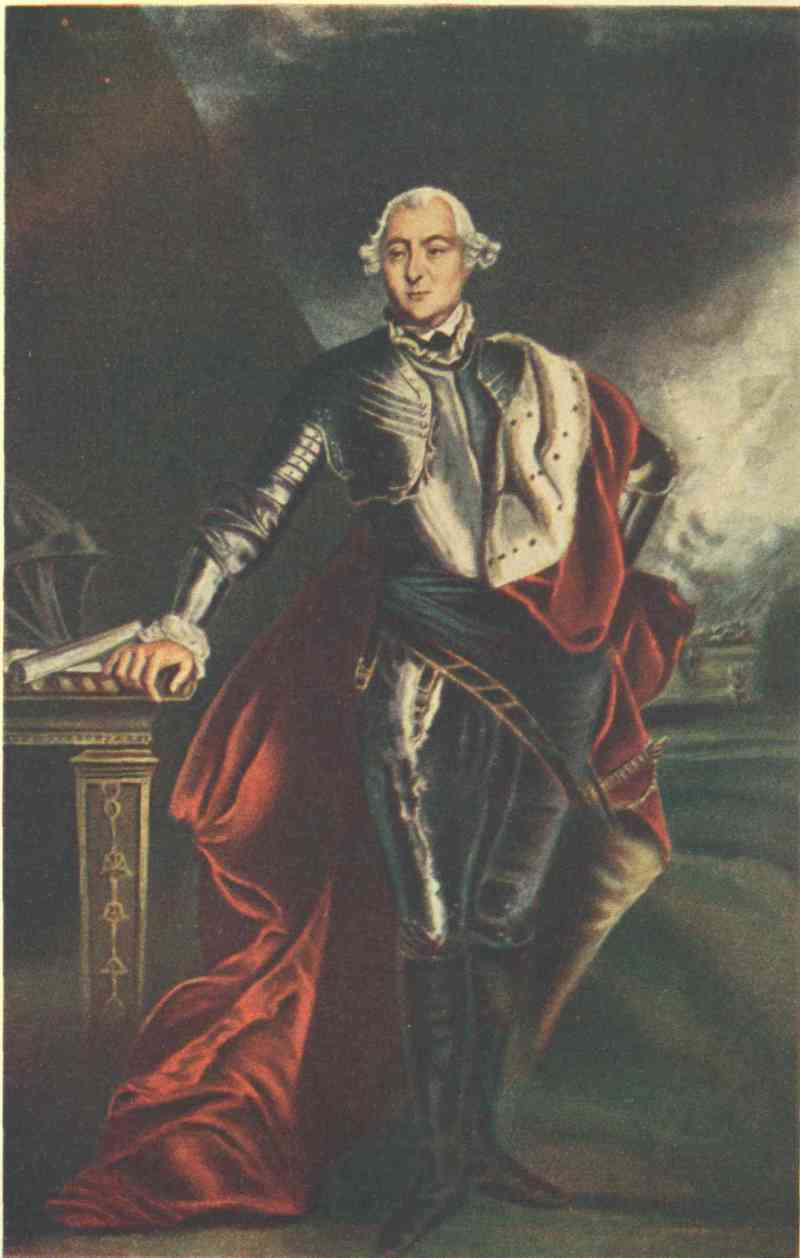
GEORGE, MARQUIS TOWNSHEND
From the painting by Sir Joshua Reynolds
4. Rain Suspends Operations, September 8-9.—After finding Cap Rouge too strong on the 7th the brigadiers went up to Pointe-aux-Trembles on the 8th, with the idea of testing its strength by a landing on the 9th; but the heavy rain compelled them to desist. In the meantime Wolfe was preparing to resume the active command. He had been visiting all the transports, where there was a great deal of discomfort from overcrowding, and had ordered that as many as possible should disembark their troops every day, for a few hours, at St Nicholas, a village on the south shore, thirteen miles above Quebec.
5. Wolfe’s Plan, September 10.—As soon as the weather cleared Wolfe went with Holmes, Monckton, Townshend, Carleton and Captain de Laune—all six disguised as privates in the Grenadiers—to the point of high land just below the mouth of the Etchemin. Here he formed his final plan, entirely on his own initiative, and without revealing it, as a whole, to any one. He saw that circumstances had made the situation particularly favourable for a master-stroke of stratagem. He knew the ground near Quebec well enough from maps, plans, spies, deserters, prisoners, and his excellent engineer and intelligence officer, Major Patrick Mackellar. He had also obtained some information from Robert Stobo, a Virginian hostage for the affair of Fort Necessity, who broke his parole, was condemned to death, was pardoned, and then escaped to spy on his generous enemy. But Stobo most certainly did not suggest this final plan, as he had left Quebec three days before, with dispatches which he delivered to Amherst at Crown Point on October 9. Wolfe was also well posted on the state of the French forces. He knew that they had been weakened by the loss of Lévis and of over a thousand good men, who had gone to Montreal to assist Bourlamaque in checking Amherst. He knew they were suffering great privations in Quebec, where casualties, disease and the increasing desertion of the Canadians were thinning their ranks. He knew their administration was corrupt, and that Vaudreuil was constantly thwarting Montcalm. And, as Vaudreuil was also an inveterate gossip, he knew most of their schemes and movements nearly as well as the men who were carrying them out.
This comprehensive knowledge enabled him to plan a surprise which would have been impossible but for the many circumstances which favoured him and baffled Montcalm. Almost opposite to him the Anse au Foulon offered a landing-place with a road which the French had often used to transport supplies across the promontory of Quebec to their camp at Beauport. This landing-place—ever since known as Wolfe’s Cove—was less than two miles from Quebec. On the heights, half-way between, lay a flat open part of the Plains of Abraham which offered an ideal site for a battlefield, if he could only forestall Montcalm. This was by no means easy, in spite of the favouring circumstances of the moment. The cliff was steep, the road narrow; any good force on top could repulse ten times its numbers; and Montcalm himself was vigilant, as was shown by his sending the battalion of Guienne to the neighbourhood. But Vaudreuil had withdrawn this battalion, and had persisted in keeping the wholly incompetent Vergor—notorious for his shameful surrender of Beauséjour—in command of the post at the head of the Foulon road, probably because Montcalm wished to replace him by the trustworthy St Martin. Thus there was nothing to fear in the immediate vicinity; only Vergor’s slovenly guard of about one hundred slack colonials, the Samos battery three hundred yards further up—four guns and a mortar, and a few patrols and sentries. The garrison of Quebec was feeble and unsuspecting. Best of all, Wolfe’s soldiers thought they were going to attack Pointe-aux-Trembles, while the French thought the attack was to be either there or against the Beauport entrenchments.
Wolfe considered all these circumstances, and all the risks inseparable from such undertakings, in the light of his knowledge, and formed his plan at once with all the skill he had earned by a lifetime of preparation. Along the thirty miles of front there was a great deal of French apprehension for the left, below Quebec, and a great deal of French and British excitement about the right, above Cap Rouge. But nobody was thinking about the centre, except Wolfe and Montcalm themselves. Wolfe knew that it was weakly guarded, that when Montcalm had reinforced it Vaudreuil had weakened it again, and that it was at least two hours out of supporting distance from the left, and twice as much out of supporting distance from the right. If he could only land by complete surprise, under present conditions success was almost certain. But this success could only be won by the perfect adjustment of every part of the fleet and army to every other part and to the whole amphibious force engaged. To bring five thousand men in three brigades by different routes or modes of conveyance; to bring them with or across a five-mile current; to do this on a pitch-black night, along a hostile shore; to land in the dark, form up in the dark, climb cliffs in the dark, and rush a post in the dark; to arrange that the boats and transports should disembark their men in the right order, and that all the different parts of the army should fit exactly into their proper places afloat and ashore, so that they might mount the cliff in one unbroken column, form on the top, advance to the battlefield without check or pause, and then deploy there into a final formation which was absolutely new to the art of war; to make all this the culmination of three nights and days of ceaseless manœuvring by land and water, over a front of thirty miles, in presence of the enemy: to do all this, and do it to perfection, was not to take Quebec by any kind of luck. Quebec was taken by sheer genius, which alone can see into the heart of complex problems, where luck itself is only a single factor that may, like any other factor, be turned to good account by the supremely fit.
6. The Battle, September 13.—On the 11th and 12th the men-of-war and transports manœuvred between Cap Rouge and Pointe-aux-Trembles, very much as they had been doing for several days past, and troops were landed for a short rest at St Nicholas, also in the usual way. Bougainville continued his exhausting vigil on shore, painfully dragging his weary two thousand backwards and forwards over exceedingly rough ground, in his faithful efforts to keep touch with an enemy who floated easily up and down with the tide. He had been employed in this way for weeks, and each week the work had become harder than before, and his half-starved men more nearly worn out by it. Yet the ceaseless patrol was well maintained, especially from the heights opposite St Nicholas up to Pointe-aux-Trembles. Precautions were taken even higher up still; for the French knew to their cost what they had suffered in August from Murray at Deschambault, forty miles above Quebec.
At Quebec itself the garrison had their attention fully employed by the Lévis batteries, which were unusually active, much in the same way as on July 31, when Wolfe had attacked the Beauport entrenchments. The bulk of the French army still had to remain in these entrenchments, because they covered the only open ground near Quebec, and because the movements of the fleet in the basin and of the troops and marines at the Island of Orleans and the ‘Point of Levy,’ looked as if designed for a renewed attack on them. On the 12th, particularly, Saunders distinctly threatened a possible landing by laying in-shore buoys and firing as if to draw the enemy, and by sending all his boats, manned and armed, to manœuvre for the supposed spot at midnight.
Meanwhile Wolfe and Montcalm never lost sight of the Foulon. Montcalm again tried to have a better man put in Vergor’s place, again tried to reinforce the patrols between Quebec and Cap Rouge, and again ordered the same battalion of Guienne back to the heights, this time to the very spot itself: ‘12th, Wednesday. Order by M. le Marquis de Montcalm to the battalion of Guienne to go and camp at the Foulon.’ But all in vain: Vaudreuil left Vergor there alone in command, and said he would look into the affairs of the Foulon ‘to-morrow morning.’ Montcalm had provided against every naval and military move, so far as his limited means allowed, and now, in spite of the fact that Wolfe’s secret plan was being worked out behind the impenetrable screen of the British fleet, he nevertheless divined it, with a genius quite equal to Wolfe’s own. But he could do no more. False friends and the fleet turned the whole scale against him.
Wolfe’s orders of the 11th and 12th gave the exact distribution of his army afloat and ashore; but no point of attack was named. No one knew it on the 10th except Holmes and Chads, who were in charge of the covering squadron and the boat-work between Cap Rouge and Pointe-aux-Trembles, where the first and second brigades were afloat under Monckton and Murray, with Wolfe, of course, in personal command. The third brigade, under Townshend, was still at Etchemin, opposite the Foulon. Its presence there naturally lent further colour to the French apprehensions about Beauport, which were strengthened by the fact that Burton’s and Carleton’s men of this brigade were plainly visible at the ‘Point of Levy’ and the Island of Orleans. Thus on the 12th there was universal interest only in what was expected to happen below Quebec and above Cap Rouge. The French below Quebec saw a very menacing fleet, two bodies of redcoats, and unusually active batteries, which were protected by redcoated marines; and they knew that another body of redcoats was within easy reach. At the same time the French above Cap Rouge saw Holmes’s fleet and convoy manœuvring up stream as usual, apparently for the attack which both sides expected at Pointe-aux-Trembles. Their attention was further directed to Pointe-aux-Trembles by the frigates which remained there, as if to cover the advance next morning. These frigates rendered Wolfe another service by stopping the French provision convoy that would otherwise have tried to creep down to the Foulon that very night. Wolfe knew this convoy had been stopped. But Montcalm, down at Beauport, and the French sentries who had orders to let it pass along the shore from Cap Rouge to the Foulon, did not know, and they were anxiously hoping that it might get down safely without being seen by the British men-of-war.
After dark the selected ships and boats were all assembled opposite Cap Rouge without having excited any unusual attention, and Wolfe’s final orders had been read out to the troops. These orders completed every detail, but were as silent as the previous ones about the point of attack: the watchword that night was ‘Coventry.’ They ended with the true ring of patriotic duty: ‘A vigorous blow struck by the army at this juncture may determine the fate of Canada. . . . The troops will land where the French seem least to expect it. . . . Officers and Men will remember what their Country expects of them.’ This, however, did not satisfy the brigadiers, three very able men, who felt slighted by being kept out of the secret, and who naturally thought that on the eve of action they should be told exactly where they were going to. At eight o’clock they handed in a joint note to Wolfe: ‘. . . we must beg leave to request from you as distinct orders as the nature of the thing will admit of, particularly of the place or places we are to attack.’ At 8.30 Wolfe replied to Monckton about the first and second brigades and separately to Townshend about the third, mentioning the Foulon to them all for the first time. It was probably on account of the coolly critical Townshend that he kept his own counsel to the last.
Then, having settled every detail of his public duty, he called his young naval friend Jervis—the future Earl of St Vincent and Nelson’s commander-in-chief—into the flagship’s cabin, where he handed over his note-book, will, and the miniature of his fiancée, Miss Lowther, afterwards Duchess of Bolton. He had long had a presentiment that he was to fall in action, and this very day, while reconnoitring from a boat, he showed how closely the idea beset him by reciting a part of Gray’s Elegy. He must have felt a poignant prophecy in the now famous line: ‘The paths of glory lead but to the grave.’ His will is remarkable for being nearly half taken up with bequests to his servants and directions about their wages and prospects. He was invariably kind to those in humble positions, and well earned his nickname of ‘The Soldier’s Friend.’ Saunders and Carleton were remembered among his friends; he directed that Miss Lowther’s miniature should be set in jewels and returned to her, and he left the residue of his estate to his ‘good mother, entirely at her disposal.’
Between nine and ten the first brigade got into the boats, which, on the signal of ‘1 light in the Sutherland’s maintop-mast shrouds,’ formed up between her and the south shore. This took till midnight. Then there was a pause of two hours more, the men, according to a letter from one of the forlorn hope, ‘waiting impatiently for the signal of proceeding. Fine weather, the night calm, and silence over all.’ At a little past two a second light was hoisted above the first, and the boats immediately began to drop down stream along the south shore, with Wolfe and de Laune’s twenty-four men of the forlorn hope in the lead. ‘Then, with a following breeze from the west, and under a clouding sky, which was reddened and torn by the flash and thunder of artillery in the east, that tense and silent British army swept down the mighty river with the ebbing tide, between those sheer black banks, and into the heart of that dark expectant night, to carry out a plan laid with such daring skill, and to win one of the great immortal battles of the world.’
At three Wolfe’s boat was nearing the Hunter, about two miles above Sillery Point. The arrangement was to round her close-to and then slant over for the north shore at Sillery, which was only half a mile above the Foulon. From two deserters on board of her Wolfe had his information about the French provision boats confirmed, and he turned it to good account when the first challenge rang out at Sillery, ‘Qui vive?’ Young Simon Fraser, a Highland officer who spoke French like a native, answered, ‘La France!’ The sentry asked, ‘What regiment?’ and Fraser replied, ‘De la Reine,’ as the British knew this regiment was furnishing the escort for the provision boats. The sentry, however, was suspicious and asked again in French, ‘Why don’t you speak louder?’ But when he received the plausible answer, ‘Keep quiet or the English will hear us,’ he let them pass on in the dark.
By four the boats had rounded in to the Foulon and Wolfe had sprung ashore. He at once formed up the forlorn hope with three light infantry companies, and led them to the steep spur marking the townward side of the cove. ‘I don’t know,’ he said, ‘if we shall be able to get up there; but we must make the attempt.’ The men scrambled up quickly, and were soon circling back to their left on the crest so as to rush Vergor. That worthy jumped out of bed at the first shot and ran for his life. The post was carried with the bayonet, and the British cheers told Wolfe, who was now back at the bottom of the path in the middle of the cove, that the first obstacle had been removed. The pioneers and remaining seven companies of light infantry, under Colonel Howe, sprang eagerly forward, threw the double abattis out of the way, climbed to the top, and were instantly followed by one battalion after another, without a break, until the whole army was formed up on the edge of the heights.
The dovetailing of the different parts was perfect. When the boats had landed the first brigade, they passed through the intervals of the second, which had followed them down in the small transports, and cut across the rapid current to Etchemin, where they took in the third. They then crossed back, again passed through the intervals of the now empty small transports, and had their leading battalion on shore soon enough for it to close up on the rear battalion of the second brigade. Meanwhile the first men up had taken the Samos battery, which stood 300 yards west, and stopped its five pieces from firing into Holmes’s men-of-war. At eight o’clock Saunders signalled for all his boats to assemble off the ‘Point of Levy,’ whence they rowed up with a strong naval brigade and all the artillery, stores and equipment that Wolfe’s men required after the battle. This supplemented the earlier efforts of Holmes’s bluejackets, who worked so well that the first field gun was brought into action against Montcalm and the second against Bougainville.
All being now secure in the immediate neighbourhood, Wolfe took the remaining seven companies of light infantry and the 58th regiment across the promontory to the Ste Foy road, from which he could see the Beauport entrenchments. There was nothing in motion there, so he marched in, seized the buildings at the junction of the road up from the St Charles with the road out from Quebec, and at once brought the rest of his army forward. His five thousand men were in twelve battalions. Of these he deployed six to his right in the first two-deep ‘thin red line’ known to the history of war. This formation was adopted because he had to command a width of three-quarters of a mile with so few men. His front occupied seven hundred yards. His right flank was secured by a battalion thrown back so far as almost to face the St Lawrence, and his left not only by a battalion similarly formed, but by the further prolongation towards his rear of Howe’s seven companies of light infantry, which could be supported by another battalion in reserve. He thus occupied the whole right half-mile, and secured himself against the left quarter-mile by three battalions ready to hold off the French irregulars, who were mostly in that direction. Another battalion was held in reserve towards the right, and the last was kept far in rear to cover the landing-place.
From eight o’clock till after nine the British waited for the French attack. There was continual skirmishing between the advanced parties and the French irregulars, especially on the left flank. But most of the men in the centre and on the right were lying down. There had been some showers, but the rain was nearly over, and the first sunshine of that memorable day was soon to make every feature of the surrounding country stand out serenely clear:
And all nature contains no scene more fit for mighty deeds than the stupendous amphitheatre in the midst of which Wolfe was waiting to play the hero’s part. For the top of the promontory made a giant stage, where his army now stood between the stronghold of New France and the whole dominion of the West. Immediately before him lay his chosen battlefield; beyond that, Quebec. To his left lay the northern theatre, gradually rising and widening, throughout all its magnificent expanse, until the far-ranging Laurentians closed in the view with their rampart-like blue semicircle of eighty miles. To his right lay the southern, where league upon league of undulating upland rolled outward to a still farther-off horizon, whose wider semicircle, curving in to overlap its northern counterpart, made the vast mountain-ring complete. While east and west, across the arena where he was about to contend for the prize of half a continent, the majestic river, full-charged with the right-hand force of Britain, ebbed and flowed, through gates of empire, on its uniting course between earth’s greatest lakes and greatest ocean. And here, too, at these Narrows of Quebec, lay the fit meeting-place of the Old World with the New. For the westward river-gate led on to the labyrinthine waterways of all America, while the eastward stood more open still—flung wide to all the Seven Seas.
Meanwhile Montcalm had had an anxious night; and when he heard the Samos battery firing into Wolfe’s second and third brigades, which did not land till after dawn, he naturally supposed it was the fleet firing into the provision convoy which he so urgently needed. None the less, he rode down to the St Charles at once, though Saunders was still threatening his camp and he could see the British tents that had been purposely left standing at the Island of Orleans and ‘Point of Levy.’ Arrived at the St Charles, he found Vaudreuil calmly writing an official letter to Bougainville, although the news that the British had landed in force was already known there. Vaudreuil then ordered Montcalm to take one hundred men to see what Wolfe was doing! But Montcalm, now catching sight of the redcoats marching in, exclaimed, ‘There they are where they have no right to be,’ and galloped off to turn out every available man, and sent the whole battalion of Guienne up the heights to reconnoitre. This was the same battalion which he had twice ordered to guard the landing-place, and which Vaudreuil had twice counterordered. Montcalm was quick in his efforts to bring his army into action. But Vaudreuil had forestalled him. When Montcalm’s aide-de-camp showed his orders to bring up the left, the commanding officer showed Vaudreuil’s orders to keep it where it was till further notice! When Montcalm applied for the twenty-five light field guns in Quebec, the commandant would only give him three, because Vaudreuil would not send a covering order! Finally, he succeeded in getting away from Vaudreuil with all the regulars—eight little battalions, under three thousand strong, and only five of them French regulars, including the badly disciplined battalion of Languedoc, which had been filled up by a gaol-bird draft sent out to replace the good men taken by Boscawen’s fleet in the Gulf in 1755. His total strength in action was about five thousand; the same as Wolfe’s in mere numbers, but very different from Wolfe’s homogeneous whole in military value.
An hour after Wolfe had formed his two-deep line of battle, Montcalm had his eight battalions half a mile off, on the inner slope of the culminating swell of ground which ran across the promontory and hid the armies from each other. He had chosen the proper ground and line of attack. Any attempt to take Wolfe in the left flank, by advancing across the marshy valley of the St Charles in full view and storming the cliffs, would have been sheer madness; worse, in every way, than Wolfe’s attempt on Montmorency. He had ridden forward to reconnoitre some time before, and had then seen the last British battalion coming up to join the reserve. He could not see Wolfe’s right, as the men were lying down behind some standing crops there. He thought they might not yet have had time to form. But the fleet and Vaudreuil and many other adverse circumstances had kept him so much in the dark that he called his brigadiers, staff and colonels to the front, and asked if any one had any positive information. The general belief was that Wolfe had not yet completed his formation, but that he was beginning to entrench, so that the only hope was an immediate attack. For other reasons, too, this was the best, and, indeed, the only course to take. Once Wolfe bestrode the promontory, Montcalm simply had to fight, starve or surrender. The single marshy road in the valley of the St Charles could never provision the twenty thousand mouths in the camp and Quebec. It was of no use to wait, as what could be gained by Bougainville’s co-operation would be more than offset by Wolfe’s entrenchments. Besides, every delay must add to the British strength, as they had the naval brigade and fleet to draw upon, as well as a few more men of their army. So Montcalm advanced his troops to the top of the swell of ground, and there deployed them into a six-deep line in full view of Wolfe a quarter of a mile away. He doubted the effectiveness of the colonial regulars; but he had no choice in the matter, and so put them on the flanks, where he hoped they would face the shock best. He knew the Languedoc battalion was untrustworthy, so he kept it in quarter column and led it into action himself.
When the formation was complete he rode down the front of his line, stopping to ask the men if they were tired, and always getting the answer from those he had so often led to victory that they were never tired before a battle. And, despite all drawbacks, they, and perhaps even he, still felt the hope of one more glory. The three brigadiers and three senior colonels were all good men. ‘Montcalm himself towered aloft and alone—the last great Frenchman of the Western World. Honoured alike by the spiteful hate of the Canadian Government, by the personal devotion of his own army, and by the soldier-like regard of his enemies, he never stood higher in all manly minds than on that fatal day. As he rode before his men there, in the full uniform of the lieutenant-general of the king, his presence seemed to call them on like a drapeau vivant of France herself.’
Wolfe had been watching closely, and as soon as the French began to form their line he moved his front a hundred paces forward, so as to commit both sides to decisive action. His orders were that the front was not to fire till he gave the signal, when the French were only forty paces off. Each of the six battalions was then to fire one double-shotted volley, close up another twenty paces to its own front, fire a ‘general’—that is, each man independently—and look for the order to charge with the bayonet. His one six-pounder now arrived, and was run out in front by the bluejackets and fired by Captain York of the Royal Artillery, who caught the nearest French in the act of deploying. But Montcalm’s men soon steadied, and, on a signal from their general, their whole line cheered loudly and began the advance, which in those days was made in slow time, with frequent halts for firing at short ranges. They all pressed on energetically for the first half of the way; but no sooner were the Canadian regulars, who had no bayonets, within extreme range, than they began firing without orders and threw themselves flat to reload. This spoilt the whole formation, as it uncovered both flanks; and the French regulars wavered and paused when they saw that, while the Canadians who remained in line evidently had no intention of getting hand to hand, the others were slinking off to join the skirmishers under cover.
Closing their ranks, however, their five battalions went on alone, though with much less assurance than before. They soon began to lose direction, their left inclining to its own left, and their centre and right to their own right. Thus they all sheered off from the British centre, where the 43rd and 47th were left without an enemy in front of them. Then the Languedoc battalion got out of hand, lost control of its fire, and spread the same sense of unsteadiness from the centre as the Canadian regulars had just been spreading from the flanks. In a moment the long months of hardship and nights of recent vigil did their unnerving work, and the whole French line was firing wildly, in an undisciplined attempt to shake the British at a distance before closing in on them for the final charge:
And it was all in vain. There stood the long, straight, two-deep line, with shouldered arms—a steadfast living wall of red, flashing defiance from its keen steel-pointed crest of bayonets—magnificently silent, yet eagerly waiting to seize the long-despaired-of chance to fight it out fairly, hand to hand, on equal terms, and in the open field. Closer and closer came the densely massed attacking line of battle, its officers leading it on with the utmost gallantry to the very last; but with its far right and left still melting away, as the Canadians sought their familiar brushwood cover, and its five French battalions still breaking it asunder, as they instinctively bore outwards from the centre to save their deserted flanks from a double overlap of fire and steel. And soon even these tried veterans lost heart a little, when they began to near the narrow forty paces where they had to meet that silently expectant line in the death-grapple which was to decide the fate of half America. They still came on, however; though now their thronged white ranks only surged forward a few steps at a time, and broke continually in wild bursts of impotent smoke, as baffled waves break short of a reef-protected shore. And, as they came, Wolfe’s straining eye was measuring every pace of that decreasing interval—a hundred—seventy-five—fifty—forty—‘Fire!’—and the first volley thundered from the Grenadiers of Louisbourg and was instantly followed by another from each battalion, all down the British line. So perfectly delivered were these famous volleys that they sounded like salvoes of artillery, and so truly aimed that the whole front rank of the French went down, almost to a man, before their terrific storm of bullets.
The 43rd and 47th regiments having no enemy in front, turned half-right and half-left to fire into the nearest opposing bodies. The five short six-deep French battalions were therefore taken on both their outer and inner flanks by the six long two-deep British battalions, which immediately closed up another twenty paces to the front under cover of their own smoke; so that when it cleared off the two armies found themselves literally face to face. The British fired again at twenty paces. The French right swayed, heaved and crumbled like a tottering wall, then broke and fled in mad confusion, followed by the centre at the moment of the British charge. The splendid battalion of Royal Roussillon stood fast a moment to receive the British right which Wolfe was leading on in person. But it also was carried away in the general rout; and victors and vanquished ran towards Quebec, pursuing and pursued.
The French made for the bridge of boats across the St Charles and got over in safety. They owed their safety in crossing the valley chiefly to a magnificent stand made by the very men who had failed to support them on the Plains. When the Highlanders reached the Côte d’Abraham they were brought to a dead stop by some Canadians who were lining the bushes on the edge of the cliff. These men fought with such determination that it took three battalions to drive them into the valley, where some of them again stood at bay till they were cut to pieces. This gallant stand reflects great credit on all classes of the French soldiery. The leader, Dumas, Beaujeu’s successor at Braddock’s defeat, was a French regular; but his men were all Canadians, regulars and militia.
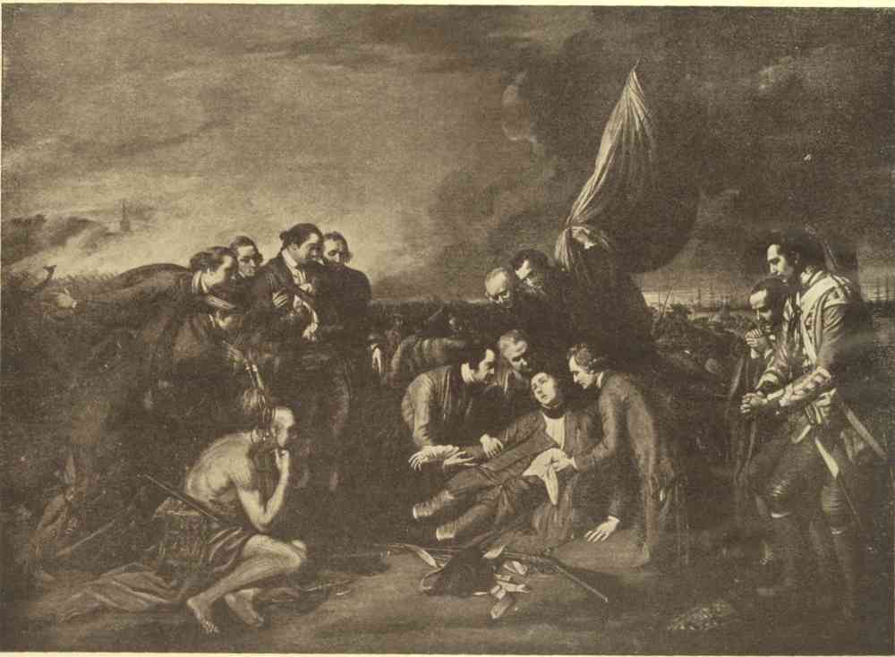
THE DEATH OF WOLFE
After the painting by Benjamin West
The British victory was completely won before Bougainville’s first men appeared about eleven o’clock. Considering his lack of information, the way in which his men were harassed, misled and worn out by the fleet, and the distance at which he had to remain from Quebec, through no fault of his own, he must be allowed the credit of having done all that any leader in his unfortunate position could possibly do. The very fact that he collected a strong force from the thirteen miles of shore-line between Cap Rouge and Pointe-aux-Trembles, and brought his men before noon on to a field between ten and fifteen miles away from where most of them had spent the last of many weary nights, is in itself sufficient evidence of his loyalty, zeal and capabilities. He made a reconnaissance in force, saw that the day was hopelessly lost, and retired to Lorette.
The British loss was only 655 killed and wounded. The French was about 1000 and a good many prisoners. But the quality of the losses on both sides was more important than its quantity. Just as the British charge began, Wolfe received his third and mortal wound. He reeled aside, half stunned by the shock, and begged the three officers who came to his assistance not to let his men see him fall. He was helped back a couple of hundred yards and seated on a grenadier’s coat. An officer on a little knoll in front of him called out, ‘They run, they run!’ ‘Who run?’ asked Wolfe, raising himself with a supreme effort. ‘The French, sir; egad! they give way everywhere!’ ‘Then I die content,’ said Wolfe, and, almost as he said it, his soaring spirit passed away.
When he fell Monckton took command, but was himself wounded almost immediately. Then Murray took charge of the pursuit up to the walls, as he had just been told that Townshend had been hit. But in a few minutes Townshend came up unwounded, as it was Carleton and not he who had been hit on the left of the line. Thus the British command-in-chief passed through the hands of all four generals in the space of one short half-hour.
But the French command-in-chief was simply swept away in blood. Montcalm, his three brigadiers—Sennezergue, Fontbonne and St Ours—and the senior colonel, Beauchâtel, were all killed or mortally wounded. When, wounded already, Montcalm was desperately trying to rally enough men to cover the retreat, he was shot through the body, and would have fallen from the saddle had not two grenadiers supported him. As he rode through St Louis Gate some terrified Quebec women cried out, ‘O my God! the marquess is killed!’ But Montcalm answered at once, ‘It is nothing—you must not distress yourselves on my account, my good friends.’ He went on down the street to the house of Dr Arnoux, who told him he had only a few more hours to live. ‘So much the better,’ he replied; ‘I shall not be a witness to the surrender of Quebec.’ He then dictated the following letter to the British commander, whom he addressed simply on the outside as ‘Monsieur,’ since no one round him at that moment knew who had succeeded Wolfe: ‘Sir,—Being obliged to surrender Quebec to your arms, I have the honour to recommend our sick and wounded to Your Excellency’s kindness, and to ask for the execution of the cartel d’échange agreed upon by His Most Christian Majesty and His Britannic Majesty. I beg Your Excellency to rest assured of the high esteem and respectful consideration with which I have the honour to be, Sir, Your most humble and most obedient servant, Montcalm.’ After this he answered an application for advice from Vaudreuil by pointing out that the only alternatives were to fight again, surrender the colony, or retreat to Jacques Cartier. He told the Chevalier de Ramezay, who commanded the garrison of the city, that he could advise no means of defending Quebec. Then his mind turned to his home and his family, to each member of which he sent a farewell message. He spent the night in receiving the consolations of religion; and, just as the dreary day was breaking, he breathed his last.
The next night, by the fitful glare of torches, he was buried in the Ursuline Chapel. As this was the only place of worship which the siege had left with a roof on, the British officers also assembled there ten days later to hear the chaplain of the flagship preach a sermon in memory of Wolfe. Montcalm is commemorated there by an inscription composed by the French Academy of that day, at the request of Bougainville, to whom Pitt wrote a letter of manly admiration for the dead hero and gave permission for the tablet to pass through the British lines by land and sea. But the tablet was unaccountably lost, and only replaced by another, with the original inscription, on the centenary of the battle, in 1859. Long before this, however, a British governor-general had put another inscription over the grave: ‘Honneur à Montcalm! Le destin, en lui dérobant la victoire, l’a récompensé par une mort glorieuse.’ The imperial forces in Canada, for their part, had commemorated Wolfe, on the spot where he died, by a monument inscribed with these four words: ‘Here died Wolfe victorious.’ And full honour has been done to both heroes together by the single monument in the governor’s garden which bears on one side the word Wolfe, on the other Montcalm, and in the centre this splendid tribute to their joint renown: ‘Mortem virtus communem, famam historia, monumentum posteritas, dedit.’
FACSIMILE OF MONTCALM’S LETTER TO THE BRITISH COMMANDER AFTER THE BATTLE OF THE PLAINS.
(Translation.)
Sir,
Being compelled to yield Quebec to your arms, I have the honour to ask your Excellency’s good offices on behalf of our sick and wounded, and to request the execution of the treaty of exchange arranged between His Most Christian Majesty and His Britannic Majesty. I beg your Excellency to accept my assurance of the high esteem and the respectful consideration with which I have the honour to be,
Sir,
Your most humble and most
obedient Servant,
MONTCALM
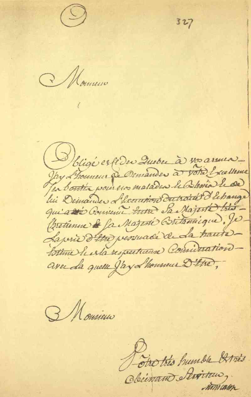
7. The Surrender of Quebec, September 18.—As soon as Bougainville left the promontory clear of enemies, Townshend entrenched for the night. This was a wise precaution. But he might have saved himself the trouble. Vaudreuil first blustered about taking his revenge, then held a council of war which decided that a retreat to Jacques Cartier was unavoidable. That retreat took place at nine o’clock, and the whole movement soon degenerated into a perfect sauve qui peut, though there was no pursuit, nor even the threat of one. Quebec was thus abandoned to its fate, and though Vaudreuil loitered about at a safe distance, he did nothing effective to relieve it. On the 17th the British batteries were ready to open fire within a quarter of a mile. Saunders closed in with an unbroken line of men-of-war stretching from the basin to Sillery, and had a strong landing party ready to attack from the lower town at the same time as the army stormed the walls, which were too weak to afford any real protection to the depleted garrison of twelve hundred effectives. Ramezay thereupon surrendered with the honours of war. The British marched in on the 18th and hoisted three Union Jacks in token of possession—one over the citadel, a second on a gun in the centre of the esplanade, and the third, which was hoisted by the men of the fleet, on the ground to the left of Mountain Hill, looking down.
Saunders presently sailed away, leaving Murray to winter in Quebec with the army. Lévis took charge of the French forces, which wintered in Montreal with Vaudreuil. And the greatest of all Canadian campaigns came to its decisive end.
The campaign of 1760 was an anticlimax. Not only had Saunders and Wolfe decided the local issues of the war at Quebec in 1759, but, in the same year, Boscawen and Hawke had clinched them, even more decisively, at sea. On August 18, when Wolfe was almost despairing at Quebec, Boscawen was smashing La Clue’s Mediterranean fleet to pieces at Lagos. And on November 20, the day Wolfe was buried amid the ‘mourning triumph’ of a whole empire, Hawke was chasing Conflans into Quiberon Bay, and there, in the full stress of a westerly gale, on a lee shore, and among all the dangers of rocks and shoals, was winning the naval counterpart to the battle of the Plains. After this, nothing but a treaty of peace could save New France in 1760.
Nevertheless Lévis made a most gallant attempt to retake Quebec and there maintain that indispensable ‘foothold in America’ which Marshal Belle-Isle had told Montcalm to keep in 1759. On April 17 he had 7260 men ready to start from Montreal, and he expected to be joined by enough of the inhabitants on the way down to bring his total up to about 12,000. He made a magnificent forced march over the almost impassable spring roads, doing nearly twenty miles a day, and that with half-fed men just out of the most miserable winter quarters. On the morning of the 28th the British marched out to meet him on the Plains, a mile beyond where Wolfe and Montcalm had met the year before. For Murray it was a choice of evils. He had only 3886 effectives left, and many of these were touched with the prevailing scurvy. But though he could put only 3000 into line of battle, and Lévis could put quite 9000, he hoped that a vigorous attack, supported by a greatly superior artillery, would give him the victory over three times his number of heterogeneous French, mostly militia.
This second battle of the Plains, better known as the battle of Ste Foy, was fought with the utmost determination on both sides, and the Canadian militia and American rangers held their own with the best. At the propitious moment Lévis galloped along his line with his hat held high on the point of his sword—a preconcerted signal—and a general charge of his whole force rolled back Murray’s long, thin, two-deep line and took all the twenty-two guns. It was a bloody field. The British lost 1124 men, more than a third of their total, but they retired in good order; and the French, who had lost half as many again, were too exhausted to pursue them.
Lévis immediately commenced his first parallel at six hundred yards from Quebec, and pressed the siege with all his might. Murray had only 2762 men left, and it began to look as if the French were going to regain their stronghold. On the evening of May 15 Lévis heard that three French ships had just come in, and he was about to storm the walls, which were quite untenable, when a prisoner told him these men-of-war were not French but British, and the vanguard of a powerful fleet. There was now nothing left to do but retire on Montreal as fast as possible, to prevent being outflanked along the river. The next morning, the 16th, Commodore Swanton attacked the French flotilla—two frigates, two armed vessels, and many small craft—that had been preserving Lévis’ line of communication. The French all cut their cables, and all but one fled in confusion. The British destroyed the four fighting ships and many of the transports in the course of the morning. But Vauquelin, who had greatly distinguished himself at Louisbourg, fought a splendid delaying action in the Atalante, which makes him worthy of sharing the French naval honours of Canada with d’Iberville, the hero of Hudson Bay. After vainly trying to head off the pursuing British frigates, Lowestoffe and Diana, he beached the Atalante on the shoals of Pointe-aux-Trembles and fought her there for two hours and a half, when he and his crew surrendered and the Atalante was burnt to the water’s edge. The arms of France thus left Quebec with all the honours of war by land and sea.
The last scene of the last act of this moving drama was now at hand. By the end of May Lévis was back in Montreal, where he remained as hopelessly isolated from the world outside as if he had been marooned on the Pacific. Step by step the few little outlying French detachments retreated before the British, who were closing in on the doomed colony from east and west and south. Day by day these retreating forces grew less and less, as the Canadians left for their homes, until, at the last, Lévis found himself shut up with a mere handful of troops and the whole brood of parasites under Bigot and Vaudreuil.
Meanwhile the American colonists had again raised large contingents to complete the conquest. There were only a handful of rangers with Murray at Quebec, about half of the nine hundred that had accompanied Wolfe. But Haviland at Crown Point and Amherst on Lake Ontario had nearly as many militiamen as regulars, and some of these militia, having now served through several campaigns, had learnt some of the cohesion of regulars without losing their own distinctive good qualities. Pitt and the colonies understood each other better than ever, and regulars and militia also formed a better combined force than they once had. The sea, of course, was absolutely British, as much so as if the shores of England touched those of Canada. And Lord Colville’s squadron, which accompanied Murray’s reinforced army to Montreal, brought direct sea-power to bear on the constricted area into which the long, grinding pressure of indirect sea-power had compelled the French to shrink exhausted in order to make their final stand.
The following entries in Colville’s private log and journal were never meant to meet the public eye. But, for that very reason, they are all the better evidence of his good work in going up the St Lawrence earlier than any other fleet and convoy, either before or since:
April 1760. Sunday. 20. In Halifax Harbour. At 6 a.m. made the signal and unmoored. Wrote to Mr. Clevland that I appointed the 14th Instant for Sailing, but a Southerly Wind prevented. Tuesday 22. At 5 a.m. made the Signal to weigh. At 7 came to Sail. The Garrison of Halifax saluted with 13 Guns. Squadron and six Sail of Vessels under Convoy for the River St Lawrence. 24. having run amongst broken Ice off Louisburg in the Night, in the Morning we could see neither Land nor Sea, tho’ the Sun shone bright: the Ships seemed fixed as in a Dock; and had the Sea risen with an increase of Wind, it must have been of very dangerous consequence. 25. the Ice dispersing we got clear of it with some difficulty. May 16. anchored with the Squadron at the Isle of Bic, after a most tedious and troublesome passage, being almost continually impeded, by running amongst great Quantities of loose Ice, and confused by thick fogs. Notwithstanding our greatest care all the Convoy lost company, more from their own bad conduct than on account of the Ice or Weather. At Bic I received a Letter from Governor Murray of Quebec, dated the 9 Instant. He acquainted me that the Enemy, having collected the whole Force of Canada, were then laying Siege to Quebec. Upon this Intelligence I sailed directly upwards with the Squadron, and on the 18, at 9 in the morning, we anchored at Quebec, where I found Captain Swanton in the Vanguard, being sent from England to reinforce me.
In September Murray, Haviland and Amherst occupied the Island of Montreal with 17,000 men, and Vaudreuil surrendered the whole of Canada by a capitulation which was signed by both sides on the 8th. The last parade state of the French army showed only 2132 men present. Most regrettably, Lévis, whose services otherwise entitle him to the highest admiration, now made the two great mistakes of his singularly adroit career. He protested against capitulating if he could not march out with all the honours, and offered to defend himself to the last man instead—which, of course, would have meant simple butchery for all his best troops. Then, seeing capitulation was inevitable, he burnt the French colours, though their delivery had been guaranteed by the terms already accepted on both sides, and he and Vaudreuil gave their word that they had no colours to deliver, as they had destroyed them some time before.
The Treaty of Versailles only confirmed the accomplished fact, and ceded to George III in 1763 the sovereignty of Canada, which had been decisively won in 1759 by the arms of George II, under the conquering leadership of Pitt, Anson, Saunders, Hawke and Wolfe.
Printed by T. and A. Constable, Printers to His Majesty
at the Edinburgh University Press
Mis-spelled words and printer errors have been fixed.
Inconsistency in hyphenation has been retained.
Illustrations have been relocated due to using a non-page layout.
Some photographs have been enhanced to be more legible.
[The end of Canada and its Provinces Vol 1 of 23 by Adam Shortt and Arthur Doughty]